SoldAntique Hand Colored Maps of The AmericasAntique Hand Colored Maps of The Americas. This lot features two 19th century hand colored maps of North America and South America from the Carey and Lee Atlas American Edition 1823-24. Both maps areSee Sold Price
Sold2 early maps, Chili & Auriacus Princip, by Ortelius.2 Antique Hand-Colored Map Prints, "Royaume de Chili", a miniature map of Chili, South America ; and "Auriacus Principatus" ( by Ortelius), showing the region around the Roman city of Orange in southeSee Sold Price
Sold18TH CENTURY MAP OF LOWER SOUTH AMERICAAntique hand-colored lithograph map reads, "Carte du Chili Meridional, du Rio de la Plata des Patagons et du Detroit de Magellan Ce quii fait l'extremite Australe de L'Amerrique Merid Par le S. D'AnviSee Sold Price
SoldJan Jansson Hand Colored Old Map of South AmericaJan Jansson (Johannes Janssonius; Dutch, 1588-1664). Framed antique etching print of South America. Titled AMERICAE PARS MERIDIONALIS. Hand colored. Unknown printing date in two sheets joined in the mSee Sold Price
Woodbridge's Antique Map of South America & Africa 18311831 map of South America & Africa for Woodbridge's Geography, hand colored engraving. A hand colored engraved map of South America and Africa printed in 1831 for Woodbridge's Geography atlas. The fulSee Sold Price
Soldlot of 2 antique maps - a hand colored "Johnson'slot of 2 antique maps - a hand colored "Johnson's South America 1863" published by Johnson & Ward - 22 1/2"x16" & a an early black & white of the Mediterranean area - 13 1/2" x 18"See Sold Price
SoldGROUP OF 5 HAND COLORED MAPS OF THE AMERICASGroups of five hand colored antique maps of the Americas, comprising "America Merioio-Nalis (South American)" circa 1620, "Tabula Magellanica Qua Tierre Del Fuego (Strait of Magellan)" circa 1640, "IlSee Sold Price
Colton: Antique Map of South America, 1859Title/Content of Map: South America by Colton Date Printed: 1859 Cartographer: H.J. Colton Material/Medium: Paper Size: 17 1/2" x 15" Hand colored, engraved Map. Published in New York in Colton's 'GenSee Sold Price
Tanner: Antique Map of South America, 1843Title/Content of Map: South America by Tanner Date Printed: 1843 Cartographer: Based on the work of H.C. Tanner Material/Medium: Paper Size: 17" x 14" Hand colored engraved Map. From the first editionSee Sold Price
Colton: Antique Map of Patagonia & Nearby Islands, 1871Title/Content of Map: South America Patagonia and nearby Islands Date Printed: 1871 Cartographer: G.W. Colton Material/Medium: Paper Size: 14" x 17 1/2" Hand colored lithograph. From 'Colton's AmericaSee Sold Price
Mitchell: Antique Map of South America, 1869Map: South America showing its political divisions Date Printed: 1869 Cartographer: Augustus S. Mitchell Material/Medium: Paper Size: 12" x 15 1/4" Hand colored engraved map. Printed in Philadelphia.See Sold Price
Sold1680 Handcolored Map of America by VisscherAuthentic antique hand-tinted map of the (now) southern U.S., Caribbean, Central America and part of South America. Made circa 1680 by Nicholas Visscher. Unframed. Nice condition, with some edge toninSee Sold Price
Sold(3) Antique Maps of South America, Caribbean Islands(3) Antique Maps of South America, Caribbean Islands. Hand colored, visible plate marks on laid paper, evidence of previous binding at center of each, printed from original plates, exact age unknown,See Sold Price
Carey & Lea - Mississippi. 29This hand-colored map engraving was part of the atlas titled A Complete Historical, Chronological, and Geographical American Atlas, being A Guide to the History of North and South America, and the WesSee Sold Price
Carey & Lea - New York. 16This hand-colored map engraving was part of the atlas titled A Complete Historical, Chronological, and Geographical American Atlas, being A Guide to the History of North and South America, and the WesSee Sold Price
SoldCarey & Lea - Cuba & Bahama Islands. 40This hand-colored map engraving was part of the atlas titled A Complete Historical, Chronological, and Geographical American Atlas, being A Guide to the History of North and South America, and the WesSee Sold Price
Carey & Lea - Jamaica. 41This hand-colored map engraving was part of the atlas titled A Complete Historical, Chronological, and Geographical American Atlas, being A Guide to the History of North and South America, and the WesSee Sold Price
Carey & Lea - Ohio. 26This hand-colored map engraving was part of the atlas titled A Complete Historical, Chronological, and Geographical American Atlas, being A Guide to the History of North and South America, and the WesSee Sold Price
SoldMitchell: Antique Map of South America, 1869Title/Content of Map: South America Date Printed: 1869 Cartographer: Augustus S. Mitchell Material/Medium: Paper Size: 12" x 15" Hand colored engraved Map. From 'Mitchell's New General Atlas.' PublishSee Sold Price
SoldColton: Antique Map of South America, 1861Title/Content of Map: South America Date Printed: 1861 Cartographer: J.H. Colton Material/Medium: Paper Size: 14" x 17 1/2" Hand colored steel engraved Map from 'Colton's General Atlas'. Published inSee Sold Price
SoldSidney Hall: Antique Map of South America, 1820Title: Map of South America Maker: Sidney Hall Date: c. 1820 Dimensions (inches): 19 x 24 Medium: Hand Colored Engraving Condition: Good Condition small rips along right side No Reserve: This lot starSee Sold Price
SoldHomann Heirs: Antique Map of North & South America 1746Title/Content of Map: Americae mappa generalis Date Printed: 1746 Cartographer: Homann Heirs Material/Medium: Paper Size: 23 1/2" x 21" Hand colored copperplate engraved. Published in Nuremberg. Map hSee Sold Price
SoldJan Jansson Colored Map of Central & South AmericaJan Jansson (Johannes Janssonius; Dutch, 1588-1664). Framed antique etching print of South and Central America. Titled TERRA FIRMA ET NOVUM REGNUM GRANATENSE ET POPAYAN. Hand colored. Unknown printingSee Sold Price
18TH C. ANTIQUE MAP: FRENCH & INDIAN WAR, FRAMEDThomaston Place Auction Galleries4.4(389)See Sold PriceFeb 24, 2024
Schomburgk - The Comuti or Taquiare (Taquiari) Rock on the River EssequiboTrillium Antique Prints & Rare Books4.5(30)See Sold PriceFeb 24, 2024
Schomburgk - Pirara and Lake Amucu, The Site of El DoradoTrillium Antique Prints & Rare Books4.5(30)See Sold PriceFeb 24, 2024
Audubon - Blue-grey Flycatcher. 70Trillium Antique Prints & Rare Books4.5(30)See Sold PriceFeb 24, 2024
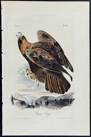
Audubon - Common Osprey Fish Hawk. 15Trillium Antique Prints & Rare Books4.5(30)See Sold PriceFeb 24, 2024
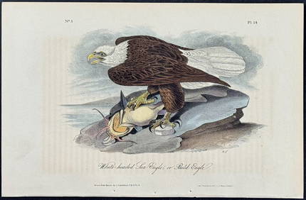
Audubon - White-headed Sea Eagle or Bald Eagle. 14Trillium Antique Prints & Rare Books4.5(30)See Sold PriceFeb 24, 2024
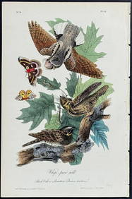
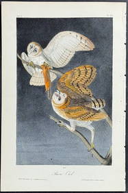
Audubon - Little Screech Owl. 40Trillium Antique Prints & Rare Books4.5(30)See Sold PriceFeb 24, 2024
Map: A 19thC engraved and hand coloured map of South America. Published by the Society for theClaydon Auctioneers Ltd4.3(125)See Sold PriceFeb 26, 2024
Map: An 18thC engraved and hand coloured map of North America and South America, titled DeClaydon Auctioneers Ltd4.3(125)See Sold PriceFeb 26, 2024