SoldANTIQUE 17th/18th c MAP ST PAULAntique 17th/18th c. Map showing the travels of The Apostles and St. Paul in the Mediterranean. Professionally framed and matted, measures 23"x26"x1". Weight 7 pds. PROVENANCE: A Private Charleston SCSee Sold Price
1701 MAP OF MOSCOVIA RUSSIA ENGLISH copper engraving ANTIQUEMoscovia or Russia. Divided into its general parts &c. by Moll, Herman (Cartographer) London, Printed for Timothy Childe at the White Hart at the West-end of St. Paul's Church-yard; 1701 size 6 1/2 bySee Sold Price
Calmet: Antique Map Malta / St. Paul’s Shipwreck, 1728Map: Ancien Plan de l'Isle de Malte, ou S. Paul Aborda apres son Naufrage, Act XXVIII Cartographer: Calmet Place & Date: Paris / 1728 Size: 17" x 12" Condition: b&w; light overall age toning The verySee Sold Price
SoldCalmet: Antique Map of Malta, St Paul’s Shipwreck, 1728Map: Ancien Plan de l'Isle de Malte, ou S. Paul Aborda apres son Naufrage, Act XXVIII Cartographer: Calmet Place & Date: Paris / 1728 Size: 17" x 12" Condition: b&w; light overall age toning The verySee Sold Price
SoldOrtelius: Antique Map of Travels of St. Paul, 1624Map: Peregrinationis Divi Pauli Typus Chorographicus. Cartographer: Abraham Ortelius Printing Date: 1624 Medium: Copperplate engraved map. Size: 18.5 x 22 Publisher: Antwerp: Officina Plantiniana, BalSee Sold Price
Stow/Strype: Antique Map of The parish of St Paul'sTITLE/CONTENT OF MAP: 'A mapp of the parish of St Paul's, Covent Garden' The map shows Covent Garden, orientated towards the west. The site of Covent Garden market is in the centre. Drury Lane is at tSee Sold Price
SoldUnknown, Portrait of a Saint, 17th/18th c., O/C.Unknown (European School). Portrait of a Saint, possibly St. Jerome or St. Paul. 17th/18th century. Oil on canvas. Water damage throughout. Canvas has been relined and varnished. Unsigned. 20" x 16".See Sold Price
Soldd'Anville: Antique Map of Brazil, 1758Map: Suite Du Bresil Publication Date: 1758 Authors: DIDOT, ANVILLE, J. B. B. d' Publisher: DIDOT Size: Octavo – 9.25 H x 6.60 W Inches "depuis la Baye de Tous les Saints jusqu'a St. Paul pour serviSee Sold Price
Sold19th c St. Paul's Beech Wood Cathedral Church ChairAn antique Church chair from St. Paul's Cathedral, London. It is of carved beech wood and rush. The chair has a curved back splat upon which , "St. Paul's" is carved. This example made in the workshopSee Sold Price
Collection of [3] antique maps - Central Europe and theVarious maps: * Map of travels and voyages of St. Paul. London, published by Mathews and Leigh, 1812. * Map of the wanderings of the Israelites in the desert. Published by J. Murray, London, 1829. * CSee Sold Price
Mallet: Antique Map of Reunion Island, 1683Title/Content of Map: 'Isle Bourbon' REUNION. Ile Bourbon Réunion Ste-Suzanne St-Paul. Indian Ocean. Date Printed: 1683 Image Size: Approx Overall page size 13 x 21cm approximately (5 x 8 inches); imSee Sold Price
Stow/Strype: Antique Map of Aldersgate Ward & StTITLE/CONTENT OF MAP: 'Aldersgate Ward and St Martins le Grand Liberty' The map covers Goswell Road/Aldersgate Street/St Martin's-le-Grand from the Barbican south to St Paul's. Little Britain is markeSee Sold Price
SoldFour 17th-18th C. Maps: Desing, Manesson-MallettCollection of four 17th and 18th European maps, Item 1: P. A. Desings map of the western hemisphere. Hand colored copper engraving published in 1741. 6 3/8" H x 5 3/4" W. Items 2 and 3: Two Manesson-See Sold Price
(3) ANTIQUE MAPS, GERMANY, 17TH & 18TH C.(lot of 3) Antique maps, including: (1) "Dithmarshen" (Northern Germany), with inset maps of "Brunsbuttel, 1644" and "Meldorpia, 1500," Johannes Mejer (German, c.1606-1674), hand colored, including seSee Sold Price
Sold29 Pieces of Antique Eastlake Brass Hardware C 1880's -29 Pieces of Antique Eastlake Brass Hardware C 1880's - Found in St Paul MN home. Largest piece 8" high. All pieces solid brass except the 3 lock sets in the middle are iron & brass. Plus the one piecSee Sold Price
SoldANTIQUE HAND PAINTED SACRED HEART OF JESUSAntique c. 1910 Hand Painted on Silk Sacred Heart of Jesus. "Sacred Heart of Jesus I Trust in Thee". 100% of the Hammer Price will benefit Charleston's Daughters of St. Paul, Roman Catholic Sisters. ISee Sold Price
SoldBellin: Suite of 3 Antique Brazil Maps, 1756Title/Content of Map: Carte du Bresil Prem. Partie [and] Suite du Bresil Depuis la Baye de Tous les Saints jusqu'a St. Paul [and on the same sheet] Suite du Bresil Cartographer: Bellin Place & Date: PSee Sold Price
SoldGreenwood (C. & J.) Map of MiddlesexGreenwood (C. & J.) Map of the County of Middlesex, engraved map of Middlesex with vignette views of Wesminster Abbey and St. Paul's Catherdral, with original hand-colouring, 540 x 660mm., a fSee Sold Price
3 Unused Antique Postcards. c. 1910s and 1935Published by C.E. Wetzel, Quincy, Ill., Steamer St. Paul on Mississippi River. Reverse is marked "C. E. W. Publisher, “Natural Color Post Card”See Sold Price
Bellin: Suite of 3 Antique Brazil Maps, 1756Map: Carte du Bresil Prem. Partie [and] Suite du Bresil Depuis la Baye de Tous les Saints jusqu'a St. Paul [and on the same sheet] Suite du Bresil Cartographer: Bellin Place & Date: Paris / 1756/1760See Sold Price
Countries embraced within the travels of St Paul. Mediterranean. HUGHES 1856 mapTITLE/CONTENT OF MAP: 'The countries embraced within the travels of St. Paul' DATE PRINTED: 1856 IMAGE SIZE: Approx 20.5 x 30.0cm, 8 x 11.75 inches (Medium) TYPE: Antique atlas map with original handSee Sold Price
3 Unused Antique Postcards. c. 1910s and 1935Published by C.E. Wetzel, Quincy, Ill., Steamer St. Paul on Mississippi River. Reverse is marked "C. E. W. Publisher, “Natural Color Post Card”See Sold Price
Countries embraced within the travels of St Paul. Mediterranean. HUGHES 1856 mapCAPTION PRINTED BELOW PICTURE: 'The countries embraced within the travels of St. Paul' DATE PRINTED: 1856 IMAGE SIZE: Approx 20.5 x 30.0cm, 8 x 11.75 inches (Medium) TYPE: Antique atlas map with origiSee Sold Price
SoldGodfrey (W.) St. Paul's CathedralGodfrey (W.) St. Paul's Cathedral:A Survey of Views, photographic plates, title soiled, original wrappers tied with cord, frayed at edges, 1934 § Sargent (Prof. C.S.) Sixteen Maps accompanyinSee Sold Price
Chicago Milwaukee and St Paul RY Panama Pacific Exposition Brochure-1915JM Hobby Supply and Railroad Artifact Auctions4.4(126)See Sold PriceFeb 24, 2024
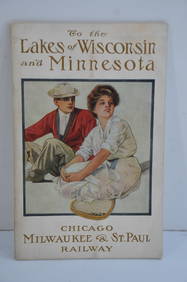
Chicago Milwaukee and St Paul RY To the Lakes of Wisconsin and Minnesota Book-1909JM Hobby Supply and Railroad Artifact Auctions4.4(126)See Sold PriceFeb 24, 2024
Chicago Milwaukee and St Paul RY Why and Wherefore Book-1886JM Hobby Supply and Railroad Artifact Auctions4.4(126)See Sold PriceFeb 24, 2024
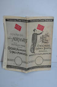
Chicago Milwaukee and St Paul RY March 1, 1889 Public TimetableJM Hobby Supply and Railroad Artifact Auctions4.4(126)See Sold PriceFeb 24, 2024
17TH C. ANTIQUE MAP SIEGE OF LA ROCHELLE, FRANCE, FRAMEDThomaston Place Auction Galleries4.4(386)See Sold PriceFeb 24, 2024
17TH C. MAP OF THE BERKSHIRES BY JOHN SPEED, FRAMEDThomaston Place Auction Galleries4.4(386)See Sold PriceFeb 24, 2024
18TH C. ANTIQUE MAP: FRENCH & INDIAN WAR, FRAMEDThomaston Place Auction Galleries4.4(386)See Sold PriceFeb 24, 2024
Chicago Milwaukee & St Paul RR Handlan Lantern-Clear Etched Barrel GlobeJM Hobby Supply and Railroad Artifact Auctions4.4(126)See Sold PriceFeb 24, 2024
Johann Homann Hand-Colored Map Engraving, c. 1730Auctions at Showplace4.5(726)See Sold PriceMar 17, 2024
Two (2) Antique 18th C. Copper Engraved Framed Maps - America & EuropeMagnusson Art Group4.5(46)See Sold PriceMar 14, 2024
1499 INCUNABULA FOLIO antique Sacred letters of St.Paul interpretation INCUNABLEJasper524.5(9.8k)See Sold PriceFeb 27, 2024
WEST AFRICA Explorers' routes Senegal Ashanti. Mountains of Kong. SDUK 1857 mapJasper524.5(9.8k)See Sold PriceFeb 28, 2024
WEST AFRICA explorers' routes. Beaufort Gray Park Dochard Caillie. SDUK 1874 mapJasper524.5(9.8k)See Sold PriceFeb 28, 2024
BRITISH AFRICAN COLONIES. West Africa Ascension St. Helena Mauritius 1876 mapJasper524.5(9.8k)See Sold PriceFeb 28, 2024
WEST AFRICA. European colonies; Mauritius; Ascension; St Helena 1907 old mapJasper524.5(9.8k)See Sold PriceFeb 28, 2024
WEST AFRICA I Explorers' routes Senegal Ashanti Ivory Gold Coast. SDUK 1851 mapJasper524.5(9.8k)See Sold PriceFeb 28, 2024
AFRICAN ISLANDS.Mauritius Madagascar Madeira Canaries St Helena 1897 old mapJasper524.5(9.8k)See Sold PriceFeb 28, 2024
WEST AFRICA showing early explorers' routes & Mountains of Kong. SDUK 1844 mapJasper524.5(9.8k)See Sold PriceFeb 28, 2024
Theo. Hamm Brewing Co. St. Paul Birds Eye Factory MapMatthew Bullock Auctioneers4.7(1.8k)See Sold PriceMar 02, 2024
HENTENIUS ANTIQUE 1547 BIBLE NEW TESTAMENT COMMENTARY ON THE LETTERS OF ST. PAULNY Elizabeth 4.3(84)See Sold PriceMar 03, 2024
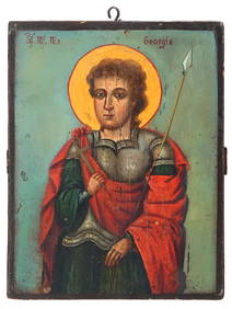
ANTIQUE 19TH C ORTHODOX ICON PAINTING OF ST GEORGEAntique Arena Inc.4.5(852)See Sold PriceMar 09, 2024


![Collection of [3] antique maps - Central Europe and the (1 of 3)](https://p1.liveauctioneers.com/2398/98907/50388426_1_x.jpg?height=282&quality=70&version=1484078795)