Hand Colored Maps; Johnson's Russia & moreJohnson's Russia by Johnson & Ward hand colored antique map. Russia on Europe hand colored map, and Suite de la Carte de La Siberie. 3 piece map collection.See Sold Price
SoldHAND COLORED ANTIQUE MAPS, EUROPE & THE WORLDHAND COLORED ANTIQUE MAPS, 3, INCLUDING JOHANN BAPTIST HOMANN & JACOBO MARCELLO, EUROPE & THE WORLD:11 1/8" x 20 1/4", 19" x 22 1/8", 19" x 23 1/4"; unframed. Ex. Collection Nancy and the late G. MennSee Sold Price
SoldAntique European Needlepoint Botanical Rug,Europe,19th Century Central tan and brown botanical medallion over ivory field surrounded by thin striped borders. Wool,9' 7" x 3', From the collection of a Providence, Rhode Island gentleman.See Sold Price
Sanson: Antique Map of Central Europe, 1645L'Allemagne par cercles [This title has been overlaid onto the original title of the map: "Carte Generale de l'Empire d'Allemagne et Pays Circonvoisins."]' The map depicts Greater Germany - The Holy RSee Sold Price
SoldBonne: Antique Map of Central Europe, 1780Title/Content of Map: 'L'Allemagne, La Boheme, et La Hongrie; avec une partie de Pologne'. A map of Central Europe from the Baltic Sea to the Gulf of Venice, including present day Germany, Poland, CzeSee Sold Price
Sold(3) ANTIQUE MAPS INCLUDING EUROPE , EUROPIA& 1744 , ENGLAND , IRELAND & SCOTLAND - LARGEST IS 28" x 22"See Sold Price
SoldAntique Map Alps Central EuropeAntique physical geography topography map. Central Europe. Alps mountains. River gods in cartouche. Hand colored engraving, 18th C. 22" x 23".See Sold Price
SoldCOLLECTION OF 3 ANTIQUE MAPSCOLLECTION OF 3 ANTIQUE MAPS: 3 framed maps total to include 1) ''Britannia Antiqua'' by John Horsley, published 1797 Cadell & Davies Strand, hand colored engraving. Sight size 9 5/8'' x 8'', framed aSee Sold Price
Sold3 Antique Maps of Continental EuropeApprox. 19" H x 22" W sight, 25" H x 28" W framed. (5229) Wear to frames.See Sold Price
SoldMclellan: Antique Map of Central & Southern Europe 1855Map: Central & Southern Europe Publication Date: 1855 Authors: HARPER & BROTHERS, MCLELLAN, D. Publisher: HARPER & BROTHERS Size: Folio – 15.10 H x 17.10 W Inches To illustrate Harper's Gazetteer. FSee Sold Price
SoldPomerania Central Europe Antique MapDucatus Pomeraniae. Hand-colored engraved map. J.B. Homann, Nuremberg, 18th C.. 21" x 24".See Sold Price
SoldCornell: Antique Map of West, Central & South EuropeTitle/Content of Map: Western, Central & Southern Continental Europe. Date Printed: 1857 Cartographer: CORNELL, SARAH SOPHIA Publisher: D. APPLETON 1857 NEW YORK Size: Folio – 12.60 H x 20.30 W InchSee Sold Price
SoldA COLLECTION OF FOUR ANTIQUE SHOFARS. Central Europe,A COLLECTION OF FOUR ANTIQUE SHOFARS. Central Europe, 19th century. Each hand carved. Various sizes.See Sold Price
SoldAntique Diagrammatic Road Map of Central EuropeAntique Framed Diagrammatic Road Map of Central Europe by Wood McMurtry. Measures 22 inches high by 28 inches wide.See Sold Price
Antique Diagrammatic Road Map of Central EuropeAntique Framed Diagrammatic Road Map of Central Europe by Wood McMurtry. Measures 22 inches high by 28 inches wide.See Sold Price
Sold3 Maps incl: Waldecciae + Potentissimae...[Homann/Central Europe]. 3 Maps. ++ Potentissimae Helvetiorum Reipublicae Cantones Tredecim cum Foederatis et Subjectis Provinciis. 19 1/8” x 22 5/8”. 2 engraved vignettes at lower left: [1] WaterSee Sold Price
Sold3 Maps incl: Regni Bohemiae... + ...Mecklenburg...[Homann/Central Europe]. 3 Maps. ++ Regni Bohemiae Circulus Rakonicensis ex Mullerianis aliisque recentissimis subsidiis chorographice designatus ut et secundum statum politcium modernum expressus etSee Sold Price
Tallis: 3 Antique Maps of Russia, 1851Title/Content of Map: 1851 Three Tallis Maps of Russia in Europe, Russia in Asia, Tartary, all in Book -- The History of Russia containing Russia in Asia; Part of Russia and Independent Tartary; RussiSee Sold Price
SoldA LOT OF 3 ANTIQUE MAPS OF THE RUSSIAN EMPIREThis lot includes a map of Crimea by Huot & Demidoff, a Spanish map of the Russian Empire and Scandinavia, and a British made map of the Central, Southern, and Northern parts of the Russian Empire. DiSee Sold Price
Weller: Antique Map of the German Confederation, 1860Map: the German Confederation and Adjacent Countries, Showing The Principal Railways of Central Europe. Publication Date: 1860 Authors: BLACKIE & SON, WELLER, EDW. Publisher: BLACKIE & SON Size: FolioSee Sold Price
SoldSmith: Antique Map of Asia, 1894Map: 1894 Smith Map of Asia [verso] South Central Europe -- Map of Asia Showing its Geopolitical Divisions, and also the Various Routes of Travel between London & India, China & Japan &c. [verso] AustSee Sold Price
Sold5 maps: West India Islands, Insulae Danicae...[Caribbean/Denmark/Central Europe] 5 Maps. Double-page. ++ West India Islands. 3 maps on 1 sheet: St. Christophers, St. Lucia, Nevis. “Engraved by Kirkwood & Son Edinburgh.” in margin. [C. 1810.]See Sold Price
Bellin: Antique Map of Central Mexico, 1754Title/Content of Map: Carte du Mexique Cartographer: Bellin Place & Date: Paris / 1754/1760 Size: 11 3/8" x 8 1/4" Condition: b&w; light overall age toning and some minor stains; a tiny repaired punctSee Sold Price
SoldJohnson: Antique Map of Central America, 1860Map: Johnson's Central America Cartographer: A.J. Johnson / Johnson and Ward Place & Date: New York / 1860 Size: 15 3/4" x 13" Condition: original color; overall age toning Despite the title change, JSee Sold Price
Antique Central Anatolian Konya Prayer Rug 5 ft 6 in x 3 ft 5 in (1.67 m x 1.04 m)Nazmiyal Auctions4.4(34)See Sold PriceFeb 25, 2024
Antique Central Anatolian Mujur Prayer Rug 5 ft 6 in x 3 ft 6 in (1.67 m x 1.06 m)Nazmiyal Auctions4.4(34)See Sold PriceFeb 25, 2024
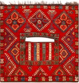
Antique Central Anatolia Kirsehir Saddle Cover 3 ft 0 in x 2 ft 11 in (0.91 m x 0.88 m)Nazmiyal Auctions4.4(34)See Sold PriceFeb 25, 2024
Set of 3 Chinese Antique Kang Xi Period Blue & White Porcelain Pedestal BowlsNeo FineArts Inc4.4(13)See Sold PriceFeb 25, 2024
Estate Collection of Antique Central Asian and Chinese TextilesMaterial Culture4.6(778)See Sold PriceFeb 29, 2024
Chatelain - 3 Maps of the British Isles (England, Ireland, Scotland)Trillium Antique Prints & Rare Books4.5(32)See Sold PriceFeb 24, 2024
1816 MAP SOUTHERN PART OF RUSSIA or MUSCOVY in EUROPE copper engraving ANTIQUEJasper524.5(9.9k)See Sold PriceFeb 28, 2024
1816 MAP NORTHERN PART OF RUSSIA or MUSCOVY in EUROPE copper engraving ANTIQUEJasper524.5(9.9k)See Sold PriceFeb 28, 2024
OSKAR KOKOSCHKA - Abstract by Austrian painter -IN THE STYLE OFABC Gallery4.2(8)See Sold PriceMar 18, 2024
OSKAR KOKOSCHKA - Abstract by Austrian origin painter - OIL ON CANVAS - IN THE STYLE OFABC Gallery4.2(8)See Sold PriceMar 18, 2024
Theodor Fischer (1862 - 1938) - Set of 4 Bird Prints - Haliaetos Albicilla - Strix LapponicaProverde Auctions4.3(3)See Sold PriceFeb 28, 2024
Theodor Fischer (1862 - 1938) - Set of 4 Bird Prints - Pernis Apivorus - Falco ArcticusProverde Auctions4.3(3)See Sold PriceFeb 28, 2024
Photography - Lot of 40 photos - Wildlife, nature and portraits photo from EuropeProverde Auctions4.3(3)See Sold PriceFeb 28, 2024
Photography - Lot of 50 photos - Wildlife, nature and portraits photo from EuropeProverde Auctions4.3(3)See Sold PriceFeb 28, 2024
Vintage Cut to Clear Ajka Crystal Footed Blue Rose Bowl/ Caviar BowlJasper524.5(9.9k)See Sold PriceMar 07, 2024
![Collection of [3] antique maps - Central Europe and the First Image](https://p1.liveauctioneers.com/2398/98907/50388426_1_x.jpg?height=282&quality=95&version=1484078795&width=282)

![Collection of [3] antique maps - Central Europe and the First Image](https://p1.liveauctioneers.com/2398/98907/50388426_1_x.jpg?height=282&quality=1&version=1484078795&width=282)