ATLAS of ANTIENT GEOGRAPHY by SAMUEL BUTLER 1843John McInnis Auctioneers,LLC4.5(505)See Sold PriceFeb 24, 2024
18TH C. ANTIQUE MAP: FRENCH & INDIAN WAR, FRAMEDThomaston Place Auction Galleries4.4(393)See Sold PriceFeb 24, 2024
Rand McNally Railroad Map Cabinet w/ 21 Railroad MapsRail & Road Auctions4.6(165)See Sold PriceMar 08, 2024
Keith Haring - Ink on New York Map, Best Buddies, Inscribed, Signed, and DatedSapphire Auction Gallery4(67)See Sold PriceMar 02, 2024
LATE 17TH C. FRENCH MAP OF THE NEW WORLD BY ALEXIS-HUBERT JAILLOT (1632-1712)Thomaston Place Auction Galleries4.4(393)See Sold PriceFeb 24, 2024
Central Railroad of New Jersey Map of Sandy Hook Route-ca. 1903JM Hobby Supply and Railroad Artifact Auctions4.4(127)See Sold PriceFeb 24, 2024
Lot of Six Mixed Atlas Box Cars-HO Scale-New in BoxJM Hobby Supply and Railroad Artifact Auctions4.4(127)See Sold PriceFeb 25, 2024
Rand McNally/Santa Fe Railroad Map of Iowa-1912JM Hobby Supply and Railroad Artifact Auctions4.4(127)See Sold PriceFeb 24, 2024
NICOLAES VISSCHER (NETHERLANDS, 1618-1709) MAP OF THE NEW WORLDThomaston Place Auction Galleries4.4(393)See Sold PriceFeb 24, 2024
17TH C. WORLD MAP BY NICOLAES VISSCHER (NETHERLANDS, 1618-1709)Thomaston Place Auction Galleries4.4(393)See Sold PriceFeb 24, 2024
Lot of Six Mixed Atlas Cabooses-HO Scale-New in BoxJM Hobby Supply and Railroad Artifact Auctions4.4(127)See Sold PriceFeb 25, 2024
SoldAnnotated Daily Telegraph War Map,Annotated Daily Telegraph War Map, British Front No.13 with hand-written notes reading, 'My Billet, 2nd Div HQ, Hell Blast Corner, 26th Batt. [trenches], Div HQ, Can. Corps HQ, 1st Heavy Battery, RegeSee Sold Price
SoldGALLIPOLI: "The Daily Telegraph War Map of theGALLIPOLI: "The Daily Telegraph War Map of the Gallipoli Peninsula (No.12)" by Alexander Gross, laid down on linen and contained within a protective cover; 87 x 55.5cms; together with, circa 1920 clotSee Sold Price
SoldMap Review Bureau of Current Affairs, No 17 NovemberMap Review Bureau of Current Affairs, No 17 November 1946, poster printed on both sides Our Food and Eastward Outlook, printed by Fosh & Cross 1946 - 77 x 102 cm; and Daily Telegraph War Map, (n.d) -See Sold Price
SoldWar. - A smal, mixed, group of war maps,including Stanford's War Map of Russia, 1854; The Daily Mail War Map, by George Philip & Son, 1914; The Daily Telegraph War Map of Europe, by Alexander Gross, 1918; Guerra Europea, an Italian photo-boSee Sold Price
Maps 20th Cent. Mixed Lot of 5 Large MapsIncl Port de Dunkerque (1965) Approaches to Le Havre (1961) Daily Telegraph War Map of the Far East (nd, C1944) Daily Telegraph War Map of the Russian Front (nd C1944) Ice Chart of the Southern HemispSee Sold Price
SoldWWI RUSSIAN EMPIRE WAR MAP by DAILY TELEGRAPH backed onBacked on linen. Size 30.5 by 39" Very good condition Printed in London. Please see my other auctions Reserve: $50.00 Shipping: Domestic: Flat-rate of $15.00 to anywhere within the contiguous U.S.See Sold Price
WWI RUSSIAN EMPIRE WAR MAP by DAILY TELEGRAPH backed onBacked on linen. Size 30.5 by 39" Very good condition Printed in London. Reserve: $69.99 Shipping: Domestic: Flat-rate of $15.00 to anywhere within the contiguous U.S. International: Foreign shippingSee Sold Price
Daily Telegraph - Map of Mediterranean and NorthernDaily Telegraph - Map of Mediterranean and Northern Africa. about 30" x 40"See Sold Price
Sold26 Volumes oN Military and RevolutionariesSHAOLIN KUNG FU - DAILY EXPRESS WAR MAP OF THE WESTERN FRONT - GURKHAS 1969 FIRST AMERICAN EDITION, WITH DUST JACKET - THE STORY OF HITLER'S YOUTH UNDER THE BLOOD BANNER, 1968 - REVOLUTIONARY MOVEMENTSee Sold Price
British militaria including commemorativeBritish militaria including commemorative handkerchiefs, LDV and fire armbands and Daily Express war map of EuropeSee Sold Price
SoldD-DAY MAP, HEAVILY ANNOTATED WITH LANDINGS AT SWORDD-DAY MAP, HEAVILY ANNOTATED WITH LANDINGS AT SWORD BEACH Finely-annotated World War II map, 30 1/2" x 37 1/2", a 1:250,000-scale depiction of the coast of France between the Cotentin Peninsula and thSee Sold Price
Sold3 Civil War map references: McElfresh, Stephenson[Reference: Civil War]. 3 Titles. Very good. ++ Civil War Maps: An Annotated List of Maps and Atlases in Map Collections of the Library of Congress. Compiled by Richard Stephenson. 1961. 8vo. Wraps. +See Sold Price
Sold3 reference books on maps[Reference]. 3 Titles. ++ Andrew M. Modelski. Railroad Maps Of North America. Wash: (GPO, 1984). Oblong Folio. 186pp. Cloth. Fine in vg dj. ++ Civil War Maps: An Annotated List of Maps and Atlases inSee Sold Price
c.1890's Map of The Atlantic OceanOriginal c.1890's map of The Atlantic Ocean, from an 1899 edition of Leslie's Official History of The Spanish American War. Map shows submarine telegraph lines. the eastern coast of The United States,See Sold Price
c.1890's Map of The Atlantic OceanOriginal c.1890's map of The Atlantic Ocean, from an 1899 edition of Leslie's Official History of The Spanish American War. Map shows submarine telegraph lines. the eastern coast of The United States,See Sold Price
SoldA cloth board folio containing a large quantity ofA cloth board folio containing a large quantity of 20thC coloured maps from The Daily Telegraph Victory Atlas of the World series by Geographia Ltd, Fleet Street, London. Edited by Alexander Gross, FRSee Sold Price
SoldSYDNEY & NEW SOUTH WALES: A small group includingSYDNEY & NEW SOUTH WALES: A small group including Robinson's "The Premier Street Directory of Sydney and Environs" 9th Ed., c.1920, "The Daily Telegraph Guide to Sydney" with folding map c.1921, "See Sold Price
War Map Issued by The Montreal Daily StarA war map issued by The Montreal Daily Star. Category2See Sold Price
SoldWar Map Issued by The Montreal Daily StarA war map issued by The Montreal Daily Star.See Sold Price
SoldWorld War II.- Newspaper Posters,World War II.- Newspaper Posters, including: Daily Telegraph - Turks' New Attitude to Soviet, n.d. [1940] § News Chronicle - Paying for the War: Details of Big Plan, n.d. [1940] § Daily TelegrSee Sold Price
SoldGross, Alexander 1920 Large Map. World HemispheresLarge Lithograph Map Published 1920, London for "The Daily Telegraph Victory Atlas of the World" by Alexander Gross. Centre fold as published. Paper Size: 25 x 19.5 inch (64 x 49cm) Good ConditionSee Sold Price
SoldChina & Japan 1895-1920 Pair of Maps. Gross, TimesLarge Lithograph Map Published 1920, London for "The Daily Telegraph Victory Atlas of the World" by Alexander Gross. Centre fold as published. Also One other Published 1895, London for "The Times AtlaSee Sold Price
SoldGross, Alexander 1920 Large Map of ArabiaLarge Lithograph Map Published 1920, London for "The Daily Telegraph Victory Atlas of the World" by Alexander Gross. Centre fold as published. Paper Size: 25 x 19.5 inch (64 x 49cm) Good ConditionSee Sold Price
SoldVintage World War 2 Period British Newspapers Group1939-1947 AD. A group of national and provincial British newspaper, mainly Daily Telegraph, Daily Express and Manchester Guardian covering the events of the Second World War including major campaigns,See Sold Price
18TH C. ANTIQUE MAP: FRENCH & INDIAN WAR, FRAMEDThomaston Place Auction Galleries4.4(393)See Sold PriceFeb 24, 2024
AMBROISE TARDIEU c1822 Napoleonic War Map GermanyLuis Porretta Fine Arts4.3(10)See Sold PriceMar 02, 2024
Large lot of assorted prints. 18th-20th century. To include: North American and other maps, CivilTremont Auctions4.5(297)See Sold PriceFeb 25, 2024
Civil War Map, Positions of the Army of the Ohio Front oh Dalton GA Dated 1864 34"L x 24"TSwisher Bros. Auction LLC4.4(255)See Sold PriceFeb 24, 2024
Civil War Map, Positions of the 16th Army Corps Dated 1864 34"L x 24"TSwisher Bros. Auction LLC4.4(255)See Sold PriceFeb 24, 2024
The First World War A Photographic History 1933. 1st EditionNorth American Artifact Auctions4.7(198)See Sold PriceApr 20, 2024
Cram's Global War Atlas 1939 Maps WWIINorth American Artifact Auctions4.7(198)See Sold PriceApr 20, 2024
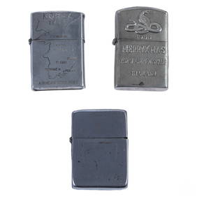
WWII Korea & Vietnam Era Silver Lighters 3pc LOTHill Auction Gallery 4.7(1k)See Sold PriceFeb 28, 2024
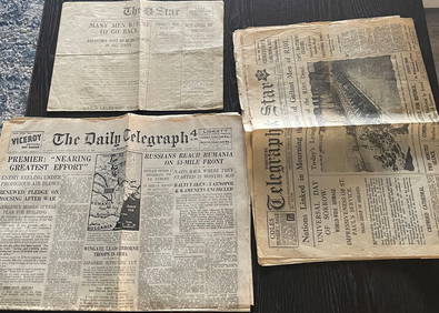
Set of War Period Newspapers from US and England 1926-1941Westmore Galleries and Auctions4.2(6)See Sold PriceMar 09, 2024
AFRICA. Antiqua; Rome Carthage, start Punic War 1908 old antique map chartJasper524.5(9.9k)See Sold PriceFeb 28, 2024
World War 2 Europe Battle of the Atlantic 1939-43 Axis Expansion limits 1959 mapJasper524.5(9.9k)See Sold PriceFeb 28, 2024
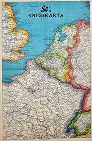
Vintage Map - På Vakts Krigskarta över Norden / On Vakt's war map of the Nordic region, SecondProverde Auctions4.3(3)See Sold PriceFeb 28, 2024
Vintage Map - Krigskarta - War Map - Second World War, published 1940Proverde Auctions4.3(3)See Sold PriceFeb 28, 2024