ATLAS of ANTIENT GEOGRAPHY by SAMUEL BUTLER 1843John McInnis Auctioneers,LLC4.5(505)See Sold PriceFeb 24, 2024
18TH C. ANTIQUE MAP: FRENCH & INDIAN WAR, FRAMEDThomaston Place Auction Galleries4.4(393)See Sold PriceFeb 24, 2024
Rand McNally Railroad Map Cabinet w/ 21 Railroad MapsRail & Road Auctions4.6(165)See Sold PriceMar 08, 2024
Keith Haring - Ink on New York Map, Best Buddies, Inscribed, Signed, and DatedSapphire Auction Gallery4.1(67)See Sold PriceMar 02, 2024
LATE 17TH C. FRENCH MAP OF THE NEW WORLD BY ALEXIS-HUBERT JAILLOT (1632-1712)Thomaston Place Auction Galleries4.4(393)See Sold PriceFeb 24, 2024
Central Railroad of New Jersey Map of Sandy Hook Route-ca. 1903JM Hobby Supply and Railroad Artifact Auctions4.4(127)See Sold PriceFeb 24, 2024
Lot of Six Mixed Atlas Box Cars-HO Scale-New in BoxJM Hobby Supply and Railroad Artifact Auctions4.4(127)See Sold PriceFeb 25, 2024
Rand McNally/Santa Fe Railroad Map of Iowa-1912JM Hobby Supply and Railroad Artifact Auctions4.4(127)See Sold PriceFeb 24, 2024
NICOLAES VISSCHER (NETHERLANDS, 1618-1709) MAP OF THE NEW WORLDThomaston Place Auction Galleries4.4(393)See Sold PriceFeb 24, 2024
17TH C. WORLD MAP BY NICOLAES VISSCHER (NETHERLANDS, 1618-1709)Thomaston Place Auction Galleries4.4(393)See Sold PriceFeb 24, 2024
Lot of Six Mixed Atlas Cabooses-HO Scale-New in BoxJM Hobby Supply and Railroad Artifact Auctions4.4(127)See Sold PriceFeb 25, 2024
SoldAncient World Divided Between Noah's 3 Sons 1683 MapAncient World. Divided Between Noah's 3 Sons. Japeth Shem Ham. Mallet 1683 Map. Title of the Map: 'la Terre Partagee Aux Trois Enfans De Noe; Ancienne Division De La Terre En Divers Peuples' australiaSee Sold Price
ANCIENT WORLD. Divided between Noah's 3 sons. JapethTITLE OF THE MAP: 'La Terre partagee aux trois enfans de Noe; Ancienne division de la Terre en divers peuples' Australia appears partly outlined. Date: 1683 IMAGE SIZE: Approx Overall page size 13 x 2See Sold Price
ANCIENT WORLD. Divided between Noah's 3 sons. JapethReserve Reduced! TITLE OF THE MAP: 'La Terre partagee aux trois enfans de Noe; Ancienne division de la Terre en divers peuples' Australia appears partly outlined. DATE PRINTED: 1683 IMAGE SIZE: ApproxSee Sold Price
ANCIENT WORLD. Divided between Noah's 3 sons. JapethTITLE OF THE MAP: 'La Terre partagee aux trois enfans de Noe; Ancienne division de la Terre en divers peuples' Australia appears partly outlined. Date: 1683 IMAGE SIZE: Approx Overall page size 13 x 2See Sold Price
Totius Orbis Terrarum Tabula Map, 1671Totius Orbis Terrarum Tabula, Eiusque Post Diluvium Divisio Inter Filios Noachi [the Ancient World as it Was Divided Among Noah's Sons After the Flood. Cartographer: J. Moxon. Place & Date: London / 1See Sold Price
SoldTWO FRAMED MAPSTWO FRAMED MAPS. 1863 AGUSTUS MITCHEL COUNTY MAP OF VIRGINIA AND WEST VIRGINIA. THE WORLD AS DIVIDED BETWEEN NOAH'S THREE SONS ACCORDING TO THE ANTIENTS. Height: 12 and 8 in. by Width: 15 and 12 in.See Sold Price
Son's of Noah: Israel, Africa & Ancient World, 1800.Original copperplate engraving by C. Taylor, published in London, 1800. Biblical map that details the Ancient worlds, and the settlements of Noah. Size: 14 x 16.5 inches Please note that this lot hasSee Sold Price
Map of the Ancient World. Augustin Calmet, c. 1740.Geographia sacra seu descriptio regionum quas trium filorum noe posteri incoluerunt . Map of the dispersal of Noah's sons; Shem, Ham and Japheth, in Asia, Europe and Africa. By Calmet Augustin, IsraelSee Sold Price
Map of the World Divided amongst the Sons of Noah.Orbis Bibliis sacris cognitus seu geographia sacra: Carte de la Geographie Sacree pour l'Ancien Testament. Map of Europe, the Near East, North Africa, divided amongst the children of Noah: Shem, Ham aSee Sold Price
Son's of Noah: Israel, Africa & Ancient World, 1800Original copperplate engraving by C. Taylor, published in London, 1800. Biblical map that details the Ancient worlds, and the settlements of Noah. Dimensions: 14 x 16.5 inchesSee Sold Price
SoldWorld.- Genesis flood.- Moxon (Joseph) A Map of all theWorld.- Genesis flood.- Moxon (Joseph) A Map of all the Earth and how after the flood it was divided among the sons of Noah, map of the World, with Eden located in modern-day Iran, surrounded with decSee Sold Price
SoldOval Map of the World, Joseph Moxon, ca. 1710"A Map of All the Earth and How After the Flood it Was Divided Among the Sons of Noah" by Joseph Moxon, ca. 1710. Hand-colored copperplate engraving. Plate dimensions: 31.5X44.5 cm. Shirley 457, LaorSee Sold Price
SoldMoxon World Map after the Flood insular Calif.Title: A Map of All the Earth and How after the Flood it was Divided among the Sons of Noah... Author: Moxon, Joseph Description: Copper-engraved map, later hand-coloring. 32x44.4 cm. (12½x17½"), maSee Sold Price
SoldMoxon (Joseph) A Map of the EarthMoxon (Joseph) A Map of the Earth and how after the Flood it was Divided among the Sons of Noah,the World in oval form, surrounded with biblical scenes from the Creation to the Crucifixion, orSee Sold Price
1820. Chart of the world as known to the Ancients,1820. Chart of the world as known to the Ancients, Divisions among the Posterity of Noah by Lavoisne. Published by Carey and Son in Philadelphia. 17 1/2” x 21 1/2”. Please note that this lot has aSee Sold Price
1820. Chart of the world as known to the Ancients,Title/Content of Map: 1820. Chart of the world as known to the Ancients, Divisions among the Posterity of Noah by Lavoisne. Size: 17 1/2” x 21 1/2” Published by Carey and Son in Philadelphia. PleaSee Sold Price
SoldAncient World Maps, Mela Posidonius & Ptolemy 1683 MapAncient World. Maps by Mela, Posidonius & Ptolemy. Mallet 1683 Old Antique. Title of the Map: 'globe De Mella; Globe De Posidonius; Globe De Ptolomee' date Printed: 1683 image Size: Approx Overall PagSee Sold Price
Sold[Middle, Near & Far East]. 3 Maps.[Middle, Near & Far East]. 3 Maps. ++ Partie Orientale De La Carte Des Ancienes Monarchies. [c1750]. Double-page engraving, 20 x 25. Fine. Political boundaries in the ancient world with perimeter of eSee Sold Price
SoldMAP - Ancient World. GoereeAncient World. Willelm & Jan Goeree, De Bekende Weereld der Ouden; Volgens Strabo, in Zeven Klimaten Afgebakend, 1700 (circa). Hand Color. This map of the ancient world is divided into seven climaticSee Sold Price
MAPS Three European MapsMAPS Three European Maps1734. 3 historical maps of the ancient world from Justinus Explicatus.... The Meditterannean, Asia Minor and Western Europe mainly. Largest measures (215 x 355 mm). ConSee Sold Price
Map history of the Apostles, 1800 (Africa, Eygpt, Asia)Original copperplate engraving by C. Taylor, published in London, 1800. Biblical map that details the Ancient worlds, and the settlements of Noah. Size: 14 x 16.5 inches Please note that this lot hasSee Sold Price
ANCIENT WORLD. Maps by Mela, Posidonius & Ptolemy. MALLET 1683 old antiqueTITLE OF THE MAP: 'Globe de Mella; Globe de Posidonius; Globe de Ptolomee' (Du Globe Terrestre) DATE PRINTED: 1683 IMAGE SIZE: Approx Overall page size 13 x 21cm approximately (5 x 8 inches); image siSee Sold Price
ANCIENT WORLD. Maps by Mela, Posidonius & Ptolemy. MALLET 1683 old antiqueTITLE OF THE MAP: 'Globe de Mella; Globe de Posidonius; Globe de Ptolomee' (Du Globe Terrestre) DATE PRINTED: 1683 IMAGE SIZE: Approx Overall page size 13 x 21cm approximately (5 x 8 inches); image siSee Sold Price
SoldCartography - a tinted etching, Sussex by Letts Son& Co;Cartography - a tinted etching, Sussex by Letts Son& Co; another map of Lincolnshire Wapontakes; a modern print - Derbyshire divided into the Hundreds (3)See Sold Price
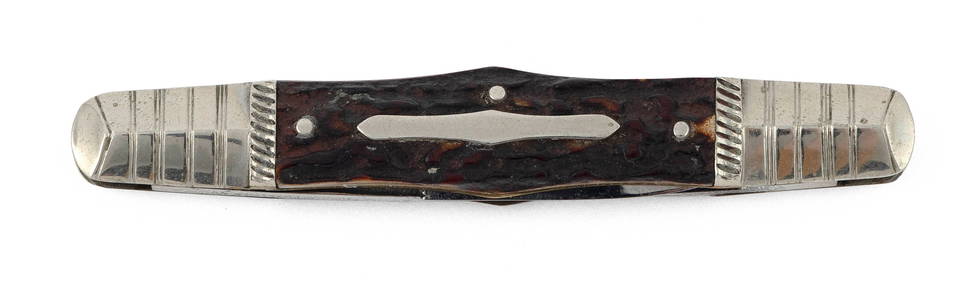
GEORGE WOSTENHOLM & SON, LTD. "SENATOR" FOUR-BLADE POCKETKNIFE Sheffield, 19th Century Length 3".Eldred's4.7(419)See Sold PriceFeb 28, 2024
GEORGE WOSTENHOLM & SON, LTD. "SENATOR" FOUR-BLADE POCKETKNIFE Sheffield, 19th Century LengthEldred's4.7(419)See Sold PriceFeb 28, 2024
JOSEPH RODGERS & SONS TWO-BLADE POCKETKNIFE Sheffield, 19th Century Length 3.25".Eldred's4.7(419)See Sold PriceFeb 28, 2024
Mattel, Barbie Dolls of The World Princess of Ancient GreeceLion and Unicorn4.8(1.9k)See Sold PriceFeb 29, 2024
Arthur Armour (1908-1998) Pair Aluminum Waste BasketsAbsolute Auction Gallery4.5(58)See Sold PriceFeb 28, 2024
16PC Dell Gold Key Movie Classic Comic GroupBruneau & Co. Auctioneers4.5(491)See Sold PriceFeb 24, 2024
1683 Sanson Map of the Caribbean -- Les Isles Antilles, &c Entre Lesquelles sont les Lucayes, et lesJasper524.5(9.9k)See Sold PriceFeb 27, 2024
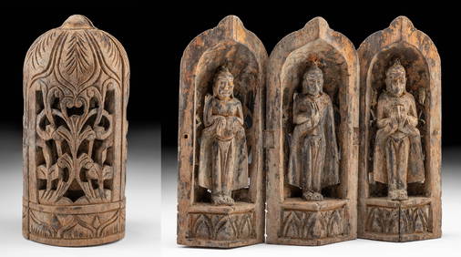
19th C. Chinese Folding Wood Travel Altar, 3 GuanyinArtemis Fine Arts4.8(1.4k)See Sold PriceFeb 26, 2024


![[Middle, Near & Far East]. 3 Maps. (1 of 2)](https://p1.liveauctioneers.com/179/1435/617510_1_x.jpg?height=282&quality=70)