ATLAS of ANTIENT GEOGRAPHY by SAMUEL BUTLER 1843John McInnis Auctioneers,LLC4.5(505)See Sold PriceFeb 24, 2024
18TH C. ANTIQUE MAP: FRENCH & INDIAN WAR, FRAMEDThomaston Place Auction Galleries4.4(394)See Sold PriceFeb 24, 2024
Rand McNally Railroad Map Cabinet w/ 21 Railroad MapsRail & Road Auctions4.6(165)See Sold PriceMar 08, 2024
Keith Haring - Ink on New York Map, Best Buddies, Inscribed, Signed, and DatedSapphire Auction Gallery4.1(67)See Sold PriceMar 02, 2024
LATE 17TH C. FRENCH MAP OF THE NEW WORLD BY ALEXIS-HUBERT JAILLOT (1632-1712)Thomaston Place Auction Galleries4.4(394)See Sold PriceFeb 24, 2024
Central Railroad of New Jersey Map of Sandy Hook Route-ca. 1903JM Hobby Supply and Railroad Artifact Auctions4.4(127)See Sold PriceFeb 24, 2024
Lot of Six Mixed Atlas Box Cars-HO Scale-New in BoxJM Hobby Supply and Railroad Artifact Auctions4.4(127)See Sold PriceFeb 25, 2024
Rand McNally/Santa Fe Railroad Map of Iowa-1912JM Hobby Supply and Railroad Artifact Auctions4.4(127)See Sold PriceFeb 24, 2024
NICOLAES VISSCHER (NETHERLANDS, 1618-1709) MAP OF THE NEW WORLDThomaston Place Auction Galleries4.4(394)See Sold PriceFeb 24, 2024
17TH C. WORLD MAP BY NICOLAES VISSCHER (NETHERLANDS, 1618-1709)Thomaston Place Auction Galleries4.4(394)See Sold PriceFeb 24, 2024
Lot of Six Mixed Atlas Cabooses-HO Scale-New in BoxJM Hobby Supply and Railroad Artifact Auctions4.4(127)See Sold PriceFeb 25, 2024
SoldAmsterdam Engraved Map by Frederik de WitCirca 1700 engraved color map of walled Amsterdam by Dutch cartographer and artist Frederik de Wit, 15 x 10.75, which is strikingly similar to a map created by Cornelis Anthoniszoon in 1538, and showsSee Sold Price
SoldFrederik de Wit, Engraved Map of Luxemburg, Amsterdam,Copper engraving on paper, with ancient colouring, mounted on cardboard Amsterdam, Netherlands, 1680 Titel: Ducatus Lutzenburgici Tabula Nuperrime in Lucem Edita per Fredericum de Wit Frederik de WitSee Sold Price
SoldPlatte Grondt der Stadt London met Nieuw Model en hoeFrederik De Wit (1630-1706). Engraved Map. Amsterdam: De Wit, c. 1666. 22 3/4 x 21 1/2 inches visible, 32 x 30 3/4 inches framed. Broadsheet map of London, published in the same year as the Great FireSee Sold Price
De Wit's Map of NorwayNorvegia Regnum. Frederik De Wit (1630-1706). Engraved map with original hand color in full. Amsterdam, 1680. 25 x 21 inches sheet. A rare and important large hand colored map of Norway and parts of SSee Sold Price
SoldDe Wit Map of the Baltic OceanDE WIT, Frederik (1629-1706). Mare Balticum / Nieuwe Pascaert van de Oost Zee. Engraved map with original hand color. Amsterdam, c. 1690 21" x 25" sheet.See Sold Price
De Wit Map of Southern SwedenDE WIT, Frederik (1629-1726). Accurata Scaniae Blekingiae et Hallandiae Descriptio. Engraved map with original hand color. Amsterdam, F. De Wit, c. 1688. 21 1/2" x 24 1/2" sheet. Regional map of southSee Sold Price
DE WIT, Frederik. Atlas. Amsterdam,DE WIT, Frederik. Atlas. Amsterdam, [c.1680] Folio (21 1/2 x 14 in). Engraved title-page, letterpress contents page, 103 double-page engraved maps, full original hand-color, split at lower edgSee Sold Price
Sold2 maps of northern Asia, c.1670, 1742[Asia]. 2 engraved double-page maps, early outline hand-coloring. ++ Frederik de Wit. Tabula Tartariae Et Majoris Partis Regni Chinae. Engraved by L'Huilier. Amst: c.1670. 17 x 21 1/2 in. Slightly tonSee Sold Price
Frederik de Wit, Copper Map of Asia, Amsterdam, 1680Frederik de Wit (1629-1706) – Dutch publisher, engraver and cartographer 'Accuratissima totius Asiae Tabula' – Splendid colored copper map of the Asian continent Published by de Wit, Antwerp, 1680See Sold Price
SoldAmericas map by de Wit, c.1680[Americas]. Frederik de Wit. Novissima Et Eaccuratissima Totius Americae Descriptio. Double-page engraved map. Amst: [1680]. 21 x 22 in. Revised edition of de Wit's issue of map by Nicolas Visscher, aSee Sold Price
SoldDe Wit. Nova et Accurata...Europae. c.1690.[Europe] de Wit, Frederick. “Nova et Accurata Divisa in Regna et Regiones Praecipuas Europae Descriptio.” Amsterdam, c.1690. Engraved map. 22 3/4” x 19 3/4”. Hand-colored. CartSee Sold Price
De Wit. Tabula Comitatus Artesiae. c.1680.[France] De Wit, Frederick. “Tabula Comitatus Artesiae emendata.” Amsterdam, c.1680. Engraved map. 21 3/4” x 18 1/8”. Hand-colored. Two colored cartouches._x000D_ Condition SpoSee Sold Price
SoldSinus Gangeticus Vulgo Golfo de Bengala Nova DescriptioFrederick De Wit (1630-1706). Amsterdam: F. De Wit, 1710. Engraved map with original hand color in full. 20 3/4 x 24 3/4 inches sheet. Extremely fine sea chart of the Bay of Bengal, showing Ceylon (SrSee Sold Price
SoldPoli Arctici et circumia centium terrarum descriptioFrederick De Wit (1629-1706). Amsterdam, 1660. Engraved map with original hand color. 21 x 24 1/2 inches visible, 32 1/2 x 36 1/4 inches framed.See Sold Price
Sold2 Maps. Circuli Saxonaie + Austria Archiducatas.[Germany] 2 Framed maps. Hondius, Henry. "Austria Archiducatus." Amsterdam, 1631. Engraved map. Hand colored. Image: 21" x 14 3/8". Framed: 29" x 23". ++ De Wit, Frederick. "Circuli Saxoniae SuperioriSee Sold Price
SoldSpain.- Wit (Frederik de) Andaluzia continens SevillamSpain.- Wit (Frederik de) Andaluzia continens Sevillam et Cordubam, southern Spain from the border of Portugal to Almeria, engraved map with hand-colouring, 355 x 500 mm., full margins, blank verso, cSee Sold Price
SoldHoly Land.- De Wit (Frederik) Terra Sancta, siveHoly Land.- De Wit (Frederik) Terra Sancta, sive Promissionis, olim Palestina…, copper engraved map, outlined in colour, title cartouche with 6 cherubs and garland, inset plan flanked by Moses andSee Sold Price
SoldWit (Frederik de) Orientalior districtus MarisWit (Frederik de) Orientalior districtus Maris Mediterranei..., hand-coloured, engraved map, from ‘Tabulae maritimae, oste zeekaerten’, no.14 upper right, plate 470 x 580mm, framed & glazSee Sold Price
Germany.- Wit (Frederik de) Ducatus Bremae & FerdaeGermany.- Wit (Frederik de) Ducatus Bremae & Ferdae Maximaeque partis fluminis visurgis, engraved map with some hand-colouring, 480 x 570 mm. (18 7/8 x 22 1/2 in), under glass, some minor surface dirtSee Sold Price
SoldDe Wit Map of Overijssel, HollandDE WIT, Frederik (1629 - 1706). Transisalania Provincia Vulgo Over-Yssel Auctore N. Ten Have... Engraved map with original hand color. Amstedam, c. 1690. 21 1/2" x 24 1/2" sheet, approx. Antique map oSee Sold Price
SoldAN ANTIQUE MAP, "Regnum Hungaria," AMSTERDAM,AN ANTIQUE MAP, "Regnum Hungaria," AMSTERDAM, 1683-1699, hand colored engraving on paper, a fragment from an atlas, printed by Frederik de Wit (1630-1706) showing the lands of Hungary subdivided by vaSee Sold Price
SoldDE WIT, FREDERICK. Occidentalior Tractus Maris MediterrDE WIT, FREDERICK Occidentalior Tractus Maris Mediterranei. Wester gedeelte van de Middelandse Zee. [Amsterdam, c. 1680]. Copper-engraved map, hand-colored in outline with hand-colored cartouches. SomSee Sold Price
Sold(MAP, SICILY) DE WIT, FREDERICK. Insula sive regnumMAP, SICILY by DE WIT, FREDERICK, Insula sive regnum Siciliae urbibus praecipuis exornatum. Amsterdam, circa 1680. Hand-colored engraved map of Sicily. With inset plans of Messina, Milazzo and PalermoSee Sold Price
(MAP, SICILY) DE WIT, FREDERICK. Insula sive regnum(MAP, SICILY) DE WIT, FREDERICK Insula sive regnum Siciliae urbibus praecipuis exornatum. Amsterdam, circa 1680. Hand-colored engraved map of Sicily. With inset plans of Messina, Milazzo and Palermo,See Sold Price
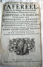
ACOBUS BASAGNE c1710 Theological History Numerous Engravings by De Hooghe Rare!Luis Porretta Fine Arts4.3(10)See Sold PriceMar 02, 2024
EARLY 18TH C. DUTCH CHART OF PACIFIC OCEAN BY FREDERIK DE WIT (1629-1706) WITH CALIFORNIA AS ANThomaston Place Auction Galleries4.4(394)See Sold PriceFeb 24, 2024
Map: A 17thC engraved and hand coloured map after Frederik de Wit (1630-1706) titled Nova Persiae,Claydon Auctioneers Ltd4.3(125)See Sold PriceFeb 26, 2024
Carte du Canal de Mosambique…. Madagascar Bonne Esperance. BONNE 1780 mapJasper524.5(9.9k)See Sold PriceFeb 28, 2024
Carte de la partie septentrionale d'Afrique, ou de la Barbarie… BONNE 1780 mapJasper524.5(9.9k)See Sold PriceFeb 28, 2024
Carte de la Haute et de la Basse Guinée. Gulf of Guinea Africa. BONNE 1780 mapJasper524.5(9.9k)See Sold PriceFeb 28, 2024
Partie Occidentale de l'Ancien Continent… W Africa Macaronesia. BONNE 1780 mapJasper524.5(9.9k)See Sold PriceFeb 28, 2024
Barthelemy, Jean 1790 Map. Greece - Essa sur la Bataille de PlateeAlbion Auctions4.7(341)See Sold PriceMar 01, 2024
Barthelemy, Jean 1790 Map. Greece - Plan de L'AcademieAlbion Auctions4.7(341)See Sold PriceMar 01, 2024
Barthelemy, Jean 1790 Map. Greece - Essai sur les Environs de DelphesAlbion Auctions4.7(341)See Sold PriceMar 01, 2024