ATLAS of ANTIENT GEOGRAPHY by SAMUEL BUTLER 1843John McInnis Auctioneers,LLC4.6(502)See Sold PriceFeb 24, 2024
18TH C. ANTIQUE MAP: FRENCH & INDIAN WAR, FRAMEDThomaston Place Auction Galleries4.4(386)See Sold PriceFeb 24, 2024
Rand McNally Railroad Map Cabinet w/ 21 Railroad MapsRail & Road Auctions4.6(165)See Sold PriceMar 08, 2024
Keith Haring - Ink on New York Map, Best Buddies, Inscribed, Signed, and DatedSapphire Auction Gallery4(67)See Sold PriceMar 02, 2024
LATE 17TH C. FRENCH MAP OF THE NEW WORLD BY ALEXIS-HUBERT JAILLOT (1632-1712)Thomaston Place Auction Galleries4.4(386)See Sold PriceFeb 24, 2024
Central Railroad of New Jersey Map of Sandy Hook Route-ca. 1903JM Hobby Supply and Railroad Artifact Auctions4.4(126)See Sold PriceFeb 24, 2024
Lot of Six Mixed Atlas Box Cars-HO Scale-New in BoxJM Hobby Supply and Railroad Artifact Auctions4.4(126)See Sold PriceFeb 25, 2024
Rand McNally/Santa Fe Railroad Map of Iowa-1912JM Hobby Supply and Railroad Artifact Auctions4.4(126)See Sold PriceFeb 24, 2024
NICOLAES VISSCHER (NETHERLANDS, 1618-1709) MAP OF THE NEW WORLDThomaston Place Auction Galleries4.4(386)See Sold PriceFeb 24, 2024
17TH C. WORLD MAP BY NICOLAES VISSCHER (NETHERLANDS, 1618-1709)Thomaston Place Auction Galleries4.4(386)See Sold PriceFeb 24, 2024
Lot of Six Mixed Atlas Cabooses-HO Scale-New in BoxJM Hobby Supply and Railroad Artifact Auctions4.4(126)See Sold PriceFeb 25, 2024
Alpes Atlas. RAYMOND. Carte topographique militaireAlpes Atlas. RAYMOND, Jean Baptiste – MICHEL, F.P. Carte topographique militaire des Alpes comprenant le Piemont, la Savoye, le Comte de Nice, le Vallais, le Duche de Genes, le Milanais et partie deSee Sold Price
(Alpes Atlas) RAYMOND. Carte des Alpes(Alpes Atlas) RAYMOND, Jean Baptiste -F.P. MICHEL. Carte topographique militaire des Alpes comprenant le Piémont, la Savoye, le Comté de Nice, le Vallais, le Duché de Gênes, le Milanais et partieSee Sold Price
[atlas] RAYMOND. Carte topographique militaire des Alps[alps atlas] RAYMOND, Jean Baptiste -F.P. MICHEL. Carte topographique militaire des Alpes comprenant le Piémont, la Savoye, le Comté de Nice, le Vallais, le Duché de Gênes, le Milanais et partie dSee Sold Price
Julien (R J) Atlas Topographique et MilitaireJulien (Roch Joseph) publisher Atlas Topographique et Militaire, engraved throughout, comprising title, 2 general plans, 55 double-page map sheets, and one battle plan, one or 2 isolated spotsSee Sold Price
SoldJulien, Roch Joseph Atlas topographique et militaire,Atlas topographique et militaire, qui comprend les Etats de la Couronne de Bohème & la Saxe Electoral avec leurs frontières. Mit Übersichtskarte, Kupfertitel, 1 Tabelle und 85 (von 92?) tls gef. geSee Sold Price
SoldJulien, R. J.: Nouveau theatre de guerreJulien, R. J. Nouveau theatre de guerre, ou Atlas topographique et militaire qui comprend le royaume de Boheme, le comte de Glatz, le marquista de Moravie, le duche de Silesie, le marquisat de Lusace,See Sold Price
Covens & Mortier: Nouvel Atlas militaire(Covens & Mortier). Nouvel Atlas militaire ou cartes très détaillées du duché de Brabant et partie de la Hollande pour l'intelligence de la guerre présente dans les Pays-BSee Sold Price
SoldParis.- Andriveau-Goujon (J.) Carte Topographique DesParis.- Andriveau-Goujon (J.) Carte Topographique Des Environs de Paris, showing from Montfort-l'Amaury to Meaux, and Plailly to Arpajon, engraved map, with hand-colouring, 690 x 1000 mm. (27 1/8 x 39See Sold Price
Maps, Ambroise Tardieu(lot of 3) Ambroise Tardieu (French, 1788–1841), "Plan de Copen-Hague," "Carte Topographique de Hohenlinden," and "Carte Topegraphique du Cours du Mayn," engravings, later prints, overall (with framSee Sold Price
1825 Renouard Map of Ancient History of Asia and PartlyTitle/Content of Map: 1825 Renouard Map of Ancient History of Asia and Partly of Europe -- Notice Historique sur la Geographie des Anciens; Explication de la Carte Topographique Ci-Dessus Date: 1825,See Sold Price
MAP - Northern France. DelisleNorthern France. Guillaume Delisle, Carte Topographique du Diocese de Senlis..., 1709 (dated). Hand Color. Beautifully engraved map of the region just north of Paris includes le Plessis Belleville, DaSee Sold Price
1825 Renouard Map of Ancient History of Asia and PartlyReserve Reduced! Map Title/Content: 1825 Renouard Map of Ancient History of Asia and Partly of Europe -- Notice Historique sur la Geographie des Anciens; Explication de la Carte Topographique Ci-DessuSee Sold Price
1825 Renouard Map of Ancient History of Asia and PartlyTitle/Content of Map: 1825 Renouard Map of Ancient History of Asia and Partly of Europe -- Notice Historique sur la Geographie des Anciens; Explication de la Carte Topographique Ci-Dessus Date: 1825,See Sold Price
1825 Renouard Map of Ancient History of Asia and PartlyTitle/Content of Map: 1825 Renouard Map of Ancient History of Asia and Partly of Europe -- Notice Historique sur la Geographie des Anciens; Explication de la Carte Topographique Ci-Dessus Date: 1825,See Sold Price
1825 Renouard Map of Ancient History of Asia and PartlyTitle: 1825 Renouard Map of Ancient History of Asia and Partly of Europe -- Notice Historique sur la Geographie des Anciens; Explication de la Carte Topographique Ci-Dessus Date: 1825, Paris CartograpSee Sold Price
Sold(EGYPT.) JACOTIN, PIERRE; AND PANCKOUCKE, CHARAN EGYPTIAN MONUMENT. (EGYPT.) JACOTIN, PIERRE; AND PANCKOUCKE, CHARLES. Carte Topographique de l'Egypte et de Plusieurs Parties des Pay Limitrophes [Atlas volume to Description de l'Egypte]. LetterpSee Sold Price
Sold1789 MAP OF WURTZBURG, GERMANY AND ENVIRONSTitled, 'Carte topographique d'Allemagne contenant une partie de Wurzbourg et Bamberg et de Fulde les Duches Saxe Cobourg, Gotha, Meinungen, Hildbourgshausen.' From the larger set 'Grand atlas d'AllemSee Sold Price
Eugene Belin, "Carte Physique et Politique de la SuisseEugene Belin, "Carte Physique et Politique de la Suisse and Sommets et Passages Pennines et des Alpes Centrales," Atlas page, H.- 9 3/4 in., W.- 13 in. H.- 9 1/2 in., W.- 13 in.See Sold Price
SoldRobert de Vaugondy, GillesRobert de Vaugondy, Gilles. Atlas portatif, universel et militaire, composé d’après les meilleures cartes, tant gravées que manuscriptes, des plus célébres geographes et ingenieurs. Parigi, a sSee Sold Price
Map of Alps. Austria/Italy/Switzerland. 1854.Print of hand colored steel engraving titled „Carte de la Chaine des Alpes“.Drawn by L. Dussieux.Engraved by unknown.From „Atlas General De Geographie physique, politique et historique par L. DuSee Sold Price
SoldBrue: Antique Map of Northern Italy & the Alps, 1875TITLE/CONTENT OF MAP: 'Carte Physique et Politique de l'Italie de la Region des Alpes et des Provinces Autrichiennes sur l'Adriatique' A physical and political map of Northern Italy and the Alps incluSee Sold Price
[History] Carte de la monarchie françoise, 1733History of Monarchy and Army of France Lemau de la Jaisse, Pierre. Carte générale de la monarchie françoise, contenant l'histoire militaire depuis Clovis... jusqu'à la quinzième année accomplieSee Sold Price
SoldLISKENNE SAUVAN Bibliothèque historique et militaLISKENNE, Ch. et SAUVAN - Bibliothèque historique et militaire. Bruxelles, J. De Mat, 1835-1853. 8 tomes in-8, demi-percaline bleue. L'Atlas forme le 8e tome; il comporte 103 (sur 104) cartes. ExSee Sold Price
SoldAuguste Jean-Marie Pavie, Mission Pavie Indo-ChineAuguste Jean-Marie Pavie, Mission Pavie Indo-Chine 1879-1895. Etudes Diverses (Vol I-III), Geographie et Voyages (Vol I-VI), Atlas, Notices et Cartes. Leather bound set of ten volumes, 9" x 11" (23 cmSee Sold Price
LARGE EARLY 18TH C. DUTCH CHART OF UPPER NORTH AMERICA, PIERRE MORTIER (1661-1711), FRAMEDThomaston Place Auction Galleries4.4(386)See Sold PriceFeb 24, 2024
1959 PETIT LAROUSSE French Dictionary EncyclopediaThe Benefit Shop Foundation Inc.4.3(2.9k)See Sold PriceMar 06, 2024
Duval - Pair: Map of India & Map of MaldivesTrillium Antique Prints & Rare Books4.5(30)See Sold PriceFeb 24, 2024
1764 Bellin Map of Mari-Galante Near Guadeloupe -- Carte de l'Isle de Mari-GalanteJasper524.5(9.8k)See Sold PriceFeb 27, 2024
1764 Bellin Map of St. Kitts -- Carte de l'Isle St. ChristopheJasper524.5(9.8k)See Sold PriceFeb 27, 2024
1764 Bellin Map of Antigua -- Carte de l'Isle d'Antigue Situee par la Latitude 17 Degres et par laJasper524.5(9.8k)See Sold PriceFeb 27, 2024
1764 Bellin Chart of Three South Haitian Bays -- Carte des Bayes du Mesle des Flamands et deJasper524.5(9.8k)See Sold PriceFeb 27, 2024
Carte de la Barbarie… l'empire de Maroc… North Africa Morocco. LAPIE 1829 mapJasper524.5(9.8k)See Sold PriceFeb 28, 2024
Carte d'Afrique. Africa Soudan Zanzibar. LAPIE 1831 old antique map plan chartJasper524.5(9.8k)See Sold PriceFeb 28, 2024
Carte de l'Afrique propre, de la Numidie… North Africa. LAPIE 1829 old mapJasper524.5(9.8k)See Sold PriceFeb 28, 2024
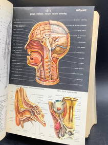
GAVOY, EMILE. 1836-1896. Atlas d'anatomie topographique du cerveau et des localisations cér...Bonhams4.1(305)See Sold PriceJun 18, 2024


![[atlas] RAYMOND. Carte topographique militaire des Alps (1 of 3)](https://p1.liveauctioneers.com/3336/104963/53821698_1_x.jpg?height=282&quality=70&version=1497520274)


![[History] Carte de la monarchie françoise, 1733 (1 of 10)](https://p1.liveauctioneers.com/2198/132390/67254832_1_x.jpg?height=282&quality=70&version=1546104781)