ATLAS of ANTIENT GEOGRAPHY by SAMUEL BUTLER 1843John McInnis Auctioneers,LLC4.6(502)See Sold PriceFeb 24, 2024
18TH C. ANTIQUE MAP: FRENCH & INDIAN WAR, FRAMEDThomaston Place Auction Galleries4.4(386)See Sold PriceFeb 24, 2024
Rand McNally Railroad Map Cabinet w/ 21 Railroad MapsRail & Road Auctions4.6(165)See Sold PriceMar 08, 2024
Keith Haring - Ink on New York Map, Best Buddies, Inscribed, Signed, and DatedSapphire Auction Gallery4(67)See Sold PriceMar 02, 2024
LATE 17TH C. FRENCH MAP OF THE NEW WORLD BY ALEXIS-HUBERT JAILLOT (1632-1712)Thomaston Place Auction Galleries4.4(386)See Sold PriceFeb 24, 2024
Central Railroad of New Jersey Map of Sandy Hook Route-ca. 1903JM Hobby Supply and Railroad Artifact Auctions4.4(126)See Sold PriceFeb 24, 2024
Lot of Six Mixed Atlas Box Cars-HO Scale-New in BoxJM Hobby Supply and Railroad Artifact Auctions4.4(126)See Sold PriceFeb 25, 2024
Rand McNally/Santa Fe Railroad Map of Iowa-1912JM Hobby Supply and Railroad Artifact Auctions4.4(126)See Sold PriceFeb 24, 2024
NICOLAES VISSCHER (NETHERLANDS, 1618-1709) MAP OF THE NEW WORLDThomaston Place Auction Galleries4.4(386)See Sold PriceFeb 24, 2024
17TH C. WORLD MAP BY NICOLAES VISSCHER (NETHERLANDS, 1618-1709)Thomaston Place Auction Galleries4.4(386)See Sold PriceFeb 24, 2024
Lot of Six Mixed Atlas Cabooses-HO Scale-New in BoxJM Hobby Supply and Railroad Artifact Auctions4.4(126)See Sold PriceFeb 25, 2024
SoldAlexis Hubert Jaillot "Estats de l'empire" engravingALEXIS HUBERT JAILLOT (French 1632-1712) "Estats de L'Empire des Turqs en Europe, subdivises suivant l'Estendue des Beglerbeglicz our Gouvernements...1700" Copperplate engraving with hand colored outlSee Sold Price
Alexis Hubert Jaillot "Estats de l'empire des Turqs enALEXIS HUBERT JAILLOT (French 1632-1712) "Estats de L'Empire des Turqs en Europe, subdivises suivant l'Estendue des Beglerbeglicz our Gouvernements...1700" Copperplate engraving with hand colored outlSee Sold Price
SoldJaillot (Hubert) Estats de l'Empire du Grand SeignJaillot (Hubert) Estats de l'Empire du Grand Seigneur des Turcs en Europe, en Asie, et en Afrique ...,map of the Middle East showing from the Mediterranean to Iran, with inset map showing theSee Sold Price
SoldAntique Map: Estats De L'Empire Du Grand Seigneur DesHighly detailed chart of the Turkish Empire, and Mediterranean, from Hubert Jaillot. Unframed, Extends from the Arabian Peninsula and the Empire of Persia in the east to Algeria, the Balearic Islands,See Sold Price
(3) RARE 17TH C. SANSON MAPS OF GERMANYAlexis-Hubert Jaillot (c. 1632-1712); Nicolas Sanson (1600-1667). All single sheet, including: "Le Duce de Iuliers"; "l'Evesche de Munster"; Le Comte de la Marck", hand colored engravings, published 1See Sold Price
Sold(3) RARE 17TH C. SANSON MAPS OF GERMANYAlexis-Hubert Jaillot (c. 1632-1712); Nicolas Sanson (1600-1667). All single sheet, including: "Le Duce de Iuliers"; "l'Evesche de Munster"; Le Comte de la Marck", hand colored engravings, published 1See Sold Price
Jaillot Engraved Map of France Post RevolutionCarte des Postes de France pour L'Annee 1786...Alexis-Hubert Jaillot (1632-1712). Engraved map with very fine color. Paris, 1786. 25 1/2 x 31 inches sheet. The Best Map of France before the RevolutionSee Sold Price
Sold[JAILLOT] MAP OF HUNGARY & SURROUNDINGS'Le Royaume De Hongrie Et Les Estats qui en ont este sujets....La Partie Septentrionale De La Turquie en Europe, by Alexis-Hubert Jaillot (ca. 1632-1712) and Guillaume Sanson (1633-1703), engraving wiSee Sold Price
Jaillot, A.H. Le Canada Dans l' AmeriqueJaillot, Alexis Hubert Le Canada ou Partie de la Nouvelle France Dans l'Amerique Septentrionale, Contenant la Terre de Labrador, la Nouvelle France... 1696 Copperplate engraving; outline coloured EachSee Sold Price
Jaillot (Alexis Hubert) L'AsieJaillot (Alexis Hubert) L'Asie, divis‚e en ses Empires, Royaumes, et Estats,Asia from the eastern Mediterranean and Egypt to Japan and the northern tip of Australia, deocrative title and scaleSee Sold Price
SoldPieter Mortier, Nicolas/Jaillot, L' Empire D'AllemagnePieter Mortier nach Sanson,Nicolas/Jaillot, A.H. L'Empire D'Allemagne distingue suivant l'etendeue de tous les estats principautes et souverainetes ... 1692 Copperplate engraving; coloured Printed areSee Sold Price
SoldJaillot (Alexis Hubert) l'Empire d'AllemagneJaillot (Alexis Hubert) l'Empire d'Allemagne,engraved map of Germany with original hand-colouring, decorative cartouche (uncoloured), 495 x 615mm., repair to lower vertical fold, lower marginSee Sold Price
SoldJaillot (Alexis Hubert) l'Empire d'AllemagneJaillot (Alexis Hubert) l'Empire d'Allemagneengraved map of Germany with original hand-colouring, decorative cartouche (uncoloured), 495 x 615mm., repair to lower vertical fold, lower margin sSee Sold Price
Jaillot (Alexis Hubert) l'Empire d'AllemagneJaillot (Alexis Hubert) l'Empire d'Allemagne, engraved map of Germany with original hand-colouring, decorative cartouche (uncoloured), 495 x 615mm., repair to lower vertical fold, lower marginSee Sold Price
SoldMap Sanson 1662 Pologne Lithuania Poland UkraineGuillaume Sanson (1633 - 1703), Alexis Hubert Jaillot (1632 - 1712) Estats dela Couronne de Pologne, subdivisss en leurs palatinats, qui comprennent le Royaume de Pologne, le Grand Duche de Lithuanie,See Sold Price
Sold[SAVOIA E PIEMONTE] JAILLOT. Les Estats de SavoyeSAVOIA E PIEMONTE. JAILLOT, Alexis-Hubert. Les Estats de Savoye et de Piémont - Le Douphiné, La Bresse partie du Lionnois et de la Provence dediéz au Roy..Paris ca 17061.260x900 mm; incisa in rameSee Sold Price
SoldJaillot (A H) Carte del L'Entrée de la Tamise[Jaillot (Alexis Hubert)] Carte del L'Entrée de la Tamise, engraved chart of the coasts of Kent, Essex, Suffolk and Norfolk, from Sandwich to Clay, inset map of the Thames Estuary to London, wSee Sold Price
SoldEngland.- East Coast.- Jaillot (Alexis-Hubert) Carte deEngland.- East Coast.- Jaillot (Alexis-Hubert) Carte de l'Entree de la Tamise avec les Bancs, Passes, Isles et Costes Comprises Entre Sandwich et Clay, large chart of the eastern coastline of EnglandSee Sold Price
SoldEngland.- River Thames.- Jaillot (Alexis-Hubert) CarteEngland.- River Thames.- Jaillot (Alexis-Hubert) Carte de l'Entree de la Tamise avec les Bancs, Passes, Isles et Costes Comprises Entre Sandwich et Clay, sea chart of the eastern coastline of EnglandSee Sold Price
SoldMortier, Jaillot. Carte du Détroit du Sond[Mortier (Pierre) and Alexis Hubert Jaillot.] Carte du Détroit du Sond contenant les Costes de l'Isle de Zélande comprises entre Nicopen et l'Isle de Meun, et celles du Schonen,with inset planSee Sold Price
SoldLa Manche, ou Le Canal, entre la France et l'AngletAlexis Hubert Jaillot, La Manche, ou Le Canal, entre la France et l'Angleterre... engraving, ca. 1706, 23 x 20 23 x 20See Sold Price
SoldL'EMPIRE DES TURQS EN EUROPE, HC ENGR, C.1655Title: Estats de l'Empire des Turqs en Europe, et Pays Circomvoisins, Pub: Nicholas Sanson, Date: C.1655, Medium: Hand-colored engraving, Paper size: 15 3/4 x 20, Inscribed: Publisher identified withiSee Sold Price
SoldMap, L'Afrique divisee suivant L'estendue de sesMap, L'Afrique divisee suivant L'estendue de ses principales parties, Alexis Hubert Jaillot after Sanson, hand colored engraved map. sight size 23" x 34 1/2".See Sold Price
SoldMAP - Baltic Sea. JaillotBaltic Sea. Alexis-Hubert Jaillot, Carte de la Mer Baltique, Contenant les Bancs, Isles et Costes Comprises Entre l'Isle de Zelande et l'Extremite du Golfe de Finlande, 1693 (circa). Black & White. ThSee Sold Price
LATE 17TH C. FRENCH MAP OF THE NEW WORLD BY ALEXIS-HUBERT JAILLOT (1632-1712)Thomaston Place Auction Galleries4.4(386)See Sold PriceFeb 24, 2024
EARLY 18TH C. DUTCH CHART OF PACIFIC OCEAN BY FREDERIK DE WIT (1629-1706) WITH CALIFORNIA AS ANThomaston Place Auction Galleries4.4(386)See Sold PriceFeb 24, 2024
LARGE EARLY 18TH C. DUTCH CHART OF UPPER NORTH AMERICA, PIERRE MORTIER (1661-1711), FRAMEDThomaston Place Auction Galleries4.4(386)See Sold PriceFeb 24, 2024
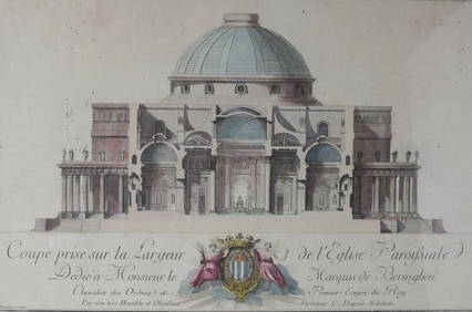
Charles Dupuis French 18th century, Pair Hand Colored Engravings, ArchitecturalGlobal Auctions Company4.3(36)See Sold PriceMar 03, 2024
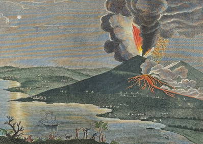
Filomarino - Mount Vesuvius Volcano Erupting. 6Trillium Antique Prints & Rare Books4.5(30)See Sold PriceFeb 24, 2024
Filomarino - Mount Vesuvius Volcano Erupting. 7Trillium Antique Prints & Rare Books4.5(30)See Sold PriceFeb 24, 2024
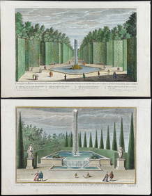
Demortain - 4 Fountain & Garden EngravingsTrillium Antique Prints & Rare Books4.5(30)See Sold PriceFeb 24, 2024
Karl Bodmer - A Young Mandan Indian. 24Trillium Antique Prints & Rare Books4.5(30)See Sold PriceFeb 24, 2024
Karl Bodmer - Assinboin Indians. 32Trillium Antique Prints & Rare Books4.5(30)See Sold PriceFeb 24, 2024
Karl Bodmer - Scalp Dance of the Minatarres. 27Trillium Antique Prints & Rare Books4.5(30)See Sold PriceFeb 24, 2024
Carte de la Barbarie… l'empire de Maroc… North Africa Morocco. LAPIE 1829 mapJasper524.5(9.8k)See Sold PriceFeb 28, 2024
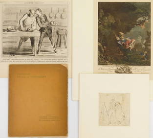
3 Works on paper and a catalog on Henry de WaroquierRachel Davis Fine Arts4.7(476)See Sold PriceMar 02, 2024
Souvenirs Et Campagnes D'un Vieux Soldat De L'empireRapid Estate Liquidators and Auction Gallery4.5(1.1k)See Sold PriceFeb 27, 2024
Souvenirs Des Guerres D'Allemagne Pendant La Révolution Et L'Empire Par Le Baron De Comeau 1900Rapid Estate Liquidators and Auction Gallery4.5(1.1k)See Sold PriceMar 03, 2024


![[JAILLOT] MAP OF HUNGARY & SURROUNDINGS (1 of 8)](https://p1.liveauctioneers.com/522/124271/63207925_1_x.jpg?height=282&quality=70&version=1530290718)


![[SAVOIA E PIEMONTE] JAILLOT. Les Estats de Savoye (1 of 2)](https://p1.liveauctioneers.com/3336/110291/57744240_1_x.jpg?height=282&quality=70&version=1511544421)