A monochromatic map of Worcestershire and WarwickA monochromatic map of Worcestershire and Warwick attributed to J. Jensson c1646. 50 x 42cmSee Sold Price
SoldA large coloured new map of Worcestershire 'dividedA large coloured new map of Worcestershire 'divided into hundreds' by John Cary dated 1801. Also a monochromatic map of the county of Derby by C&I Greenwood, published 1830. Two items.See Sold Price
BENG Morden (Robert) Warwick Shire; Worcester ShirBENG Morden (Robert) Warwick Shire; Worcester Shire; Huntington Shire; ComitatusRotelandiæ, 4 engraved county maps, all but the last with hand-colouring, 290 x 370mm. to 370 x 430mm., eaSee Sold Price
SoldMoule, Thomas C1838 British Map. WorcestershireSteel Engraved Map Published C1838 for "A Complete and Universal English Dictionary" by the Rev. James Barclay et al. Maps by Thomas Moule. Paper Size: 10.5 x 8 inch (27 x 21cm) Good ConditionSee Sold Price
SoldA monochromatic map of Britannica Rumin Sularum TypusA monochromatic map of Britannica Rumin Sularum Typus by A. Ortelious c1595. 50 x 36cm.See Sold Price
SoldA monochromatic map of Tornacum attributed to Braun andA monochromatic map of Tornacum attributed to Braun and Hogenberg c1680, 45 x 38cm.See Sold Price
SoldA monochromatic map of Brightstowe, probably by BraunA monochromatic map of Brightstowe, probably by Braun and Hogenberg. 35 x 45cm.See Sold Price
SoldMoule, Thomas C1835 British Map. WorcestershireSteel Engraved Map Published C1835, London for "A Complete and Universal English Dictionary" by the Rev. James Barclay et al. Maps by Thomas Moule. Paper Size: 11 x 8.5 inch (28 x 22cm) Tiny tone spotSee Sold Price
SoldA mainly monochromatic map of Greece 'Auctore J.A mainly monochromatic map of Greece 'Auctore J. Laurenbergio, 56 x 46cm.See Sold Price
SoldA monochromatic map of Cornwall by ChristopherA monochromatic map of Cornwall by Christopher Saxton/William Kip c1610, 29 x 38cm.See Sold Price
SoldVINTAGE ATLAS MAP, WARWICK, BELLVALE & FLORIDA, NY.VINTAGE ATLAS MAP, WARWICK, BELLVALE & FLORIDA, NY. FRAMED & GLAZED-21 X 31"See Sold Price
SoldA largely monochromatic map of the county of Sussex 'A largely monochromatic map of the county of Sussex 'described by John Norden, augmented by John Speede..' 50 x 39cmSee Sold Price
Moule, Thomas C1835 British Map. WorcestershireSteel Engraved Map Published C1835, London for "A Complete and Universal English Dictionary" by the Rev. James Barclay et al. Maps by Thomas Moule. Paper Size: 11 x 8.5 inch (28 x 22cm) Tiny tone spotSee Sold Price
SoldA mainly monochromatic map of Wollaton Hall, in theA mainly monochromatic map of Wollaton Hall, in the county of Nottingham, the seat of the Honourable Sir Thomas Willoughby, Baronett by L. Knuff, engraved by Kip. 49 x 36cm.See Sold Price
A monochromatic map of London and the MetropolitanA monochromatic map of London and the Metropolitan Boroughs 'as defined by the Reform Bill' dated 1832. 59 x 51cmSee Sold Price
SoldA monochromatic map of the 'Countie of Radnor describedA monochromatic map of the 'Countie of Radnor described and the Shyretownes sittauatione' dated 1618 described by Christopher Saxton, augmented and published by John Speed. 52 x 39cmSee Sold Price
SoldA monochromatic map of 'The Countie of Nottingham'A monochromatic map of 'The Countie of Nottingham' described 'The Shire Townes Situation and the Earls thereof observed' by John Speed and dated c1610. 52 x 40cm. Slightly AF to centrefold.See Sold Price
SoldA monochromatic map of Rutlandshire with ' Oukham andA monochromatic map of Rutlandshire with ' Oukham and Stanford', her bordering neighbour Newely described by John Speed c1676, 51 x 38cm.See Sold Price
A monochromatic map of Flintshire by John Speed,A monochromatic map of Flintshire by John Speed, bearing date 1610 upon, measuring 50 x 40cm.See Sold Price
Two monochromatic maps of North Wales by Walker c1837Two monochromatic maps of North Wales by Walker c1837 and a similar map of North Wales also by Walker, handtinted. Three items.See Sold Price
SoldA mixed group of county mapsBritish Isles.- A mixed group of county maps, Worcestershire, Devonshire, Westmoreland, Shropshire, Derbyshire, Middlesex, Northumberland, Durham, Glocestershire, Shropshire, for or by W.Kip,See Sold Price
Worcester Shire...Title/Content of Map: Worcester Shire... Date: 1695 Cartographer: MORDEN, ROBT. Size: 14X16.6 County map from Camden's Britannia. Please note that this lot has a confidential reserve. When you leave aSee Sold Price
SoldFARM MAP OF WARWICK NEW YORK, HUGHES 1863FARM MAP OF WARWICK NEW YORK, HUGHES 1863 41" X 56"See Sold Price
SoldAntique map of Worcestershire by Willem Janszoon BlaeuCopper plate engraved and hand colored map; Wigorniensis Comitatus Et Comitatus Warwicensis; Nec Non Coventrae Libertas. published in "Guil. et Ioannis Blaeu Theatrum Orbis Terrarum, sive Atlas NovusSee Sold Price
Central Railroad of New Jersey Map of Sandy Hook Route-ca. 1903JM Hobby Supply and Railroad Artifact Auctions4.4(127)See Sold PriceFeb 24, 2024
Cincinnati Hamilton and Dayton RR Map -USGC 1889JM Hobby Supply and Railroad Artifact Auctions4.4(127)See Sold PriceFeb 24, 2024
Northern Pacific RR Washington and Northern Idaho Map Folder-1941JM Hobby Supply and Railroad Artifact Auctions4.4(127)See Sold PriceFeb 24, 2024
Rand McNally/Santa Fe Railroad Map of Iowa-1912JM Hobby Supply and Railroad Artifact Auctions4.4(127)See Sold PriceFeb 24, 2024
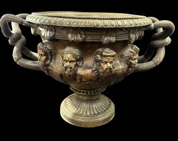
Barbedienne Bronze French Warwick Large Urn Circa 1860sCowboy Joe's Antiques4.7(201)See Sold PriceFeb 27, 2024
17TH C. WORLD MAP BY NICOLAES VISSCHER (NETHERLANDS, 1618-1709)Thomaston Place Auction Galleries4.4(393)See Sold PriceFeb 24, 2024
LATE 17TH C. FRENCH MAP OF THE NEW WORLD BY ALEXIS-HUBERT JAILLOT (1632-1712)Thomaston Place Auction Galleries4.4(393)See Sold PriceFeb 24, 2024
18TH C. ANTIQUE MAP: FRENCH & INDIAN WAR, FRAMEDThomaston Place Auction Galleries4.4(393)See Sold PriceFeb 24, 2024
NICOLAES VISSCHER (NETHERLANDS, 1618-1709) MAP OF THE NEW WORLDThomaston Place Auction Galleries4.4(393)See Sold PriceFeb 24, 2024
Nova Totius Full Color Geographical World MapThe Benefit Shop Foundation Inc.4.3(2.9k)See Sold PriceFeb 28, 2024
Civil War Map, Positions of the Army of the Ohio Front oh Dalton GA Dated 1864 34"L x 24"TSwisher Bros. Auction LLC4.4(255)See Sold PriceFeb 24, 2024
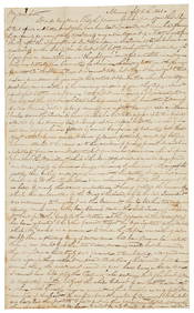
Keith Haring - Ink on New York Map, Best Buddies, Inscribed, Signed, and DatedSapphire Auction Gallery4.1(67)See Sold PriceMar 02, 2024
Rand McNally Railroad Map Cabinet w/ 21 Railroad MapsRail & Road Auctions4.6(165)See Sold PriceMar 08, 2024
Jean Hugo (French, 1894–1984) - Les Sorcières, WarwickFreeman's | Hindman4.5(158)See Sold PriceFeb 28, 2024
Willem Blaeu, Etc. 17th C. Antiquarian Maps, 2Auctions at Showplace4.6(740)See Sold PriceMar 17, 2024
Putnam - First Map of the State of Ohio by Rufus PutnamTrillium Antique Prints & Rare Books4.5(32)See Sold PriceFeb 24, 2024
De Jode, Rare, pub. 1593 - Map of Africa (Africae Vera Forma, et Situs)Trillium Antique Prints & Rare Books4.5(32)See Sold PriceFeb 24, 2024