SoldA monochromatic map of Cornwall by ChristopherA monochromatic map of Cornwall by Christopher Saxton/William Kip c1610, 29 x 38cm.See Sold Price
SoldMap, William Kip after Christopher Saxton, CornwallWilliam Kip (Dutch, c.1585 - 1618) after Christopher Saxton (British, c.1540 - c.1610), "Cornwall Olim Pars Danmoniorum," 1637, hand-colored copper engraved map, plate signed and titled upper center,See Sold Price
SoldChristopher Saxton & William Kip map of Cornwall, OLIMChristopher Saxton & William Kip map of Cornwall, OLIM PARS DANMONIORUM, coloured engraving, circa 1637, H.30cm W.39cmSee Sold Price
SoldA monochromatic map of the 'Countie of Radnor describedA monochromatic map of the 'Countie of Radnor described and the Shyretownes sittauatione' dated 1618 described by Christopher Saxton, augmented and published by John Speed. 52 x 39cmSee Sold Price
SoldSaxton Map of CornwallSaxton, Christopher (1540-1610). [Cornwall, England] Promontorium hoc in mare proiectum cornubia dicitur... Engraved map with original hand color. London, 1579. 16 3/8" x 21 1/4" sheet. The first prinSee Sold Price
SoldCornwall.- Saxton (Christopher) & Philip Lea.Cornwall.- Saxton (Christopher) & Philip Lea. Cornwall... Corrected & Many Additions in the Roads, county map with inset view of Launceston surmounted by Royal coat-of-arms, and decorated with ships,See Sold Price
SoldSaxton (Christopher) & Kip (William) Cornwall olim parsSaxton (Christopher) & Kip (William) Cornwall olim pars Danmoniorum, large inset view of Launceston, Royal arms, embellished with compasses, marine monster and sailing ship, engraved map by WilliamSee Sold Price
SoldSaxton (Christopher) and William Kip. Cornwall oliSaxton (Christopher) and William Kip. Cornwall olim pars Danmoniorum,large inset view of Launceston upper left, strapwork title cartouche upper right, ship and sea monster, engraved map with eSee Sold Price
SoldMoule, Thomas C1850 British Map. CornwallSteel Engraved Map Published C1850 "A Complete and Universal English Dictionary" by the Rev. James Barclay et al. Maps by Thomas Moule. Paper Size: 10.5 x 8 inch (27 x 21cm) Good ConditionSee Sold Price
SoldMoule, Thomas C1838 British Map. CornwallSteel Engraved Map Published C1838 for "A Complete and Universal English Dictionary" by the Rev. James Barclay et al. Maps by Thomas Moule. Paper Size: 10.5 x 8 inch (27 x 21cm) A couple of tiny toneSee Sold Price
SoldA monochromatic map of Britannica Rumin Sularum TypusA monochromatic map of Britannica Rumin Sularum Typus by A. Ortelious c1595. 50 x 36cm.See Sold Price
SoldMoule, Thomas C1838 British Map. CornwallSteel Engraved Map Published C1838 for "A Complete and Universal English Dictionary" by the Rev. James Barclay et al. Maps by Thomas Moule. Paper Size: 10.5 x 8 inch (27 x 21cm) Good ConditionSee Sold Price
SoldA monochromatic map of Tornacum attributed to Braun andA monochromatic map of Tornacum attributed to Braun and Hogenberg c1680, 45 x 38cm.See Sold Price
SoldA monochromatic map of Brightstowe, probably by BraunA monochromatic map of Brightstowe, probably by Braun and Hogenberg. 35 x 45cm.See Sold Price
SoldA mainly monochromatic map of Greece 'Auctore J.A mainly monochromatic map of Greece 'Auctore J. Laurenbergio, 56 x 46cm.See Sold Price
Map, CornwallCopper-engraved map with hand-coloring, "Cornwall," engraved by Bingley, published by Simpkin & Marshall, overall (with frame): 9.5"h x 11"wSee Sold Price
SoldA largely monochromatic map of the county of Sussex 'A largely monochromatic map of the county of Sussex 'described by John Norden, augmented by John Speede..' 50 x 39cmSee Sold Price
SoldA mainly monochromatic map of Wollaton Hall, in theA mainly monochromatic map of Wollaton Hall, in the county of Nottingham, the seat of the Honourable Sir Thomas Willoughby, Baronett by L. Knuff, engraved by Kip. 49 x 36cm.See Sold Price
A monochromatic map of London and the MetropolitanA monochromatic map of London and the Metropolitan Boroughs 'as defined by the Reform Bill' dated 1832. 59 x 51cmSee Sold Price
A monochromatic map of Worcestershire and WarwickA monochromatic map of Worcestershire and Warwick attributed to J. Jensson c1646. 50 x 42cmSee Sold Price
SoldA monochromatic map of 'The Countie of Nottingham'A monochromatic map of 'The Countie of Nottingham' described 'The Shire Townes Situation and the Earls thereof observed' by John Speed and dated c1610. 52 x 40cm. Slightly AF to centrefold.See Sold Price
SoldMap: ''Cornwall'' A c1800 Copperplate Engraved map ofMap: ''Cornwall'' A c1800 Copperplate Engraved map of '' Cornwall Drawn from and Actual Survey...' by T.Kitchin' with later coloured details, in 21stC frame, a copy of the map originally published inSee Sold Price
SoldA monochromatic map of Rutlandshire with ' Oukham andA monochromatic map of Rutlandshire with ' Oukham and Stanford', her bordering neighbour Newely described by John Speed c1676, 51 x 38cm.See Sold Price
A monochromatic map of Flintshire by John Speed,A monochromatic map of Flintshire by John Speed, bearing date 1610 upon, measuring 50 x 40cm.See Sold Price
Central Railroad of New Jersey Map of Sandy Hook Route-ca. 1903JM Hobby Supply and Railroad Artifact Auctions4.4(127)See Sold PriceFeb 24, 2024
Rand McNally/Santa Fe Railroad Map of Iowa-1912JM Hobby Supply and Railroad Artifact Auctions4.4(127)See Sold PriceFeb 24, 2024
17TH C. WORLD MAP BY NICOLAES VISSCHER (NETHERLANDS, 1618-1709)Thomaston Place Auction Galleries4.4(394)See Sold PriceFeb 24, 2024
LATE 17TH C. FRENCH MAP OF THE NEW WORLD BY ALEXIS-HUBERT JAILLOT (1632-1712)Thomaston Place Auction Galleries4.4(394)See Sold PriceFeb 24, 2024
18TH C. ANTIQUE MAP: FRENCH & INDIAN WAR, FRAMEDThomaston Place Auction Galleries4.4(394)See Sold PriceFeb 24, 2024
17TH C. ENGLISH LINEAR MAP BY OGILBY, FRAMEDThomaston Place Auction Galleries4.4(394)See Sold PriceFeb 24, 2024
NICOLAES VISSCHER (NETHERLANDS, 1618-1709) MAP OF THE NEW WORLDThomaston Place Auction Galleries4.4(394)See Sold PriceFeb 24, 2024
CHRISTOPHER "CHRIS" HUNTINGTON (ME/CAN, 1938 - )Thomaston Place Auction Galleries4.4(394)See Sold PriceFeb 25, 2024
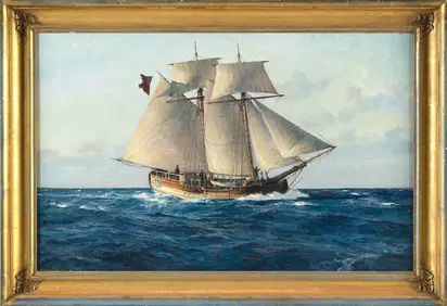
CHRISTOPHER BLOSSOM (Connecticut, 1956-), "Colonial Schooner Halifax"., Oil on canvas, 17" x 27".Eldred's4.7(423)See Sold PriceFeb 27, 2024
Keith Haring - Ink on New York Map, Best Buddies, Inscribed, Signed, and DatedSapphire Auction Gallery4.1(67)See Sold PriceMar 02, 2024
Rand McNally Railroad Map Cabinet w/ 21 Railroad MapsRail & Road Auctions4.6(165)See Sold PriceMar 08, 2024
Putnam - First Map of the State of Ohio by Rufus PutnamTrillium Antique Prints & Rare Books4.5(33)See Sold PriceFeb 24, 2024
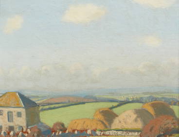
Robert Morson Hughes, Farm Buildings in CornwallAndrew Jones Auctions4.7(208)See Sold PriceFeb 28, 2024
1750 Bowen Map of Bermuda and St. Kitts -- A New & Accurate Map of Bermudas or Sommer's Islands...Jasper524.5(9.9k)See Sold PriceFeb 27, 2024
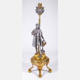
Victorian Christopher Columbus Kerosene Floor LampGray's Auctioneers4.5(187)See Sold PriceMar 06, 2024
Per Olof Christopher Aurivillius (1843-1928) - Set of 3 Prints - ButterfliesProverde Auctions4.3(3)See Sold PriceFeb 28, 2024
Per Olof Christopher Aurivillius (1843-1928) - Set of 3 Prints - Butterflies in SwedenProverde Auctions4.3(3)See Sold PriceFeb 28, 2024
Per Olof Christopher Aurivillius (1843-1928) - Set of 3 Prints - Butterflies - ScandinaviaProverde Auctions4.3(3)See Sold PriceFeb 28, 2024