ATLAS of ANTIENT GEOGRAPHY by SAMUEL BUTLER 1843John McInnis Auctioneers,LLC4.5(505)See Sold PriceFeb 24, 2024
18TH C. ANTIQUE MAP: FRENCH & INDIAN WAR, FRAMEDThomaston Place Auction Galleries4.4(394)See Sold PriceFeb 24, 2024
Rand McNally Railroad Map Cabinet w/ 21 Railroad MapsRail & Road Auctions4.6(165)See Sold PriceMar 08, 2024
Keith Haring - Ink on New York Map, Best Buddies, Inscribed, Signed, and DatedSapphire Auction Gallery4.1(67)See Sold PriceMar 02, 2024
LATE 17TH C. FRENCH MAP OF THE NEW WORLD BY ALEXIS-HUBERT JAILLOT (1632-1712)Thomaston Place Auction Galleries4.4(394)See Sold PriceFeb 24, 2024
Central Railroad of New Jersey Map of Sandy Hook Route-ca. 1903JM Hobby Supply and Railroad Artifact Auctions4.4(127)See Sold PriceFeb 24, 2024
Lot of Six Mixed Atlas Box Cars-HO Scale-New in BoxJM Hobby Supply and Railroad Artifact Auctions4.4(127)See Sold PriceFeb 25, 2024
Rand McNally/Santa Fe Railroad Map of Iowa-1912JM Hobby Supply and Railroad Artifact Auctions4.4(127)See Sold PriceFeb 24, 2024
NICOLAES VISSCHER (NETHERLANDS, 1618-1709) MAP OF THE NEW WORLDThomaston Place Auction Galleries4.4(394)See Sold PriceFeb 24, 2024
17TH C. WORLD MAP BY NICOLAES VISSCHER (NETHERLANDS, 1618-1709)Thomaston Place Auction Galleries4.4(394)See Sold PriceFeb 24, 2024
Lot of Six Mixed Atlas Cabooses-HO Scale-New in BoxJM Hobby Supply and Railroad Artifact Auctions4.4(127)See Sold PriceFeb 25, 2024
SoldFramed Hand Colored Map of The World 19th CenturyFramed Hand Colored Map of The World 19th Century. Original Map of World Hemispheres with supposed population and religious division. Certificate of Authenticity on back.Condition: Very Good, slight wSee Sold Price
SoldCirca 150 loose world maps, 19th and 20th century,Circa 150 loose world maps, 19th and 20th century, including both coloured and uncoloured, (quantity)See Sold Price
SoldCirca 100 loose world maps, 19th and 20th century,Circa 100 loose world maps, 19th and 20th century, including both coloured and uncoloured, (quantity)See Sold Price
SoldKeith Johnston Edinburgh Map of ASIA19th Century world map of ASIA by KEITH JOHNSTON F.R.S.E. Engraved and printed by W & AK Johnston Edinburgh & London. Approx. 24" x 19.5" and in good, age appropriate condition as shown, see photos.See Sold Price
SoldFolk Art Double-Hemisphere World Map Folk Art Double-Hemisphere World Map American, 19th century. Ink and watercolor on paper. A folk art double-hemisphere world map, featuring hand-drawn and labeled continents, oceans, and countries,See Sold Price
Sold1843 Folding Color German World Maps Europe Americas1843 Folding Color German World Maps Europe Americas Geography Austria RARE Three 19th-century world maps published in Vienna in 1843! Published for use in Austrian high schools, this atlas includes fSee Sold Price
SoldFramed Needlework Map of The New WorldFramed Needlework Map of The New World 19th CenturySee Sold Price
SoldGrp: 54 Maps of the World 18th and 19th c.Group of 54 maps of various regions of the world, dating from the 18th and 19th century. Foldable Map of Navarre on paper attached to linen, Tomás López de Vargas Machuca (1730-1802) "Map of theSee Sold Price
SoldWorld Map in Hemispheres 19th CMap: Mapemonde. (World map in hemispheres) Maker: Unknown Origin: French, 19th Century Medium: Original lithograph with hand coloring. Sheet Size: 6 1/4 x 9 inches No Reserve: This lot starts at $1 anSee Sold Price
SoldLot of 19th Century U.S. & World Maps.This lot contains numerous maps of the U.S. and the world. Condition (Very Good).See Sold Price
SoldFramed needlework on linen of the hemispheres titled ÒAFramed needlework on linen of the hemispheres titled ÒA Map of the World, probably late 19th c. 18.5h.x31.5"w."See Sold Price
SoldLg Framed early 19th c. Map of the WorldLg Framed early 19th c. Map of the World, "Mappe Monde", Indication des trois voyages du Capitaine Cook, French 1816 in floral gilt 32" x 46" frame Condition; was folded, some wear along fold lines frSee Sold Price
Sold1884 BEAUTIFUL 9v Appleton American Cyclopaedia World1884 BEAUTIFUL 9v Appleton American Cyclopaedia World History Maps In the late 19th-century, the Appleton publishing company printed an enormous multi-volume encyclopedia of American biography. This sSee Sold Price
SoldCram's Atlas, Other MapsGeorge Cram, "Atlas of the World", 1901. 19th and 20th century maps (5) of Europe including Patteson, Rand McNally, Wyld & Thomson, Dodd Mead. Atlas is 15" x 12"x 2.5"See Sold Price
SoldRare 1st ed. map of world diseases, c1848World map showing the spread of diseases across the globe in mid-19th century. Three inset maps show diseases in North America, the spread of cholera throughout the world and South Africa. Charts andSee Sold Price
SoldExtremely Rare 19th Century Stamp Collection BookExtremely rare 19th century stamp collection books; contains over 1000 stamps of world categorized by countries, including United States, United Kingdom, Canada, France and etc; with world map; _x000DSee Sold Price
SoldA World Map on Mercator's ProjectionA World Map on Mercator's Projection George F. Cram Co., Chicago, 19th/20th Century 17 7/8 x 26 1/8 inches (visible). Property from a Corporate Art CollectionSee Sold Price
Sold1850 Petermann World Map of the Human RaceTitle/Content of Map: 1850 Petermann World Map of the Human Race -- Ethnographical Map of the World Showing the Distribution of the Human Race in the Middle of the 19th Century Date Printed: 1850, LonSee Sold Price
SoldLarge ms. Japanese World MapHeading: (World) Author: Title: [Manuscript World map] Place Published: Publisher: Date Published: No date [19th century] Description: Ink on paper, backed with silk. 135.See Sold Price
SoldWorld Views 19th Century Lot of 300+ Illustrated SheetsBig lot of over 300 Sheets, each containing one or more Wood Engraving. All with veso text. Incl Holy Land, Italy, Asia, Norway, Arctic, North Africa, China, Japan, Australia, New Zealand etc. ExampleSee Sold Price
SoldEarly 19th century School Girl Embroidery of OldEarly 19th century School Girl Embroidery of Old World-New world maps surrounded by floral garland decoration. Loss to silk and embroidery. Framed. Overall size: 21" x 29".See Sold Price
SoldCOLLECTION OF 18TH AND 19TH CENTURY MAPS.COLLECTION OF 18TH AND 19TH CENTURY MAPS. Comprised of fifteen maps varying from world maps, Asia, Africa, South America, and others. All engravings, some hand colored Largest: 11.5" x 19"See Sold Price
SoldBronze Plaque "Putti at Play" Circa 1880Great quality gilt bronze 19th century plaque depicting 4 putti playing amongst telescope, world map and other related objects, good condition, 15.5" x 2.75"See Sold Price
Mitchell - Map of the City of Washington (Washington, DC)Trillium Antique Prints & Rare Books4.5(33)See Sold PriceFeb 24, 2024
1816 MAP SOUTHERN PART OF RUSSIA or MUSCOVY in EUROPE copper engraving ANTIQUEJasper524.5(9.9k)See Sold PriceFeb 27, 2024
1816 MAP NORTHERN PART OF RUSSIA or MUSCOVY in EUROPE copper engraving ANTIQUEJasper524.5(9.9k)See Sold PriceFeb 27, 2024
1738 BIBLE in DUTCH ILLUSTRATED w/ MAPS antique MASSIVE FOLIO BIBLIAJasper524.5(9.9k)See Sold PriceFeb 27, 2024
Blackie (Pub) 1882 Folio Map. World on Mercators ProjectionAlbion Auctions4.7(341)See Sold PriceMar 01, 2024
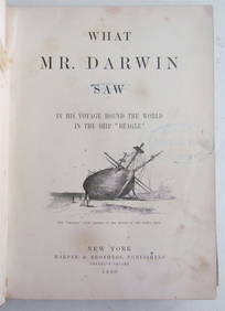
1880 WHAT MR. DARWIN SAW IN SHIP BEAGLE ANTIQUE DURING HIS WORLD TOURNY Elizabeth 4.1(88)See Sold PriceMar 03, 2024
Rare 19thc Colton Map, Argentine Republic, Chile, Uruguay, PataguayConnoisseur Auctions3.9(337)See Sold PriceMar 16, 2024
Joseph Meyer - Set of 12 Prints - Prag - Czech Republic - Germany - Buchberg - Nachod - JohannisbergProverde Auctions4.3(3)See Sold PriceFeb 28, 2024
Joseph Meyer - Set of 50 Prints - Views of Austria - Germany - Italy - Sweden - France - CzechProverde Auctions4.3(3)See Sold PriceFeb 28, 2024
Joseph Meyer - Set of 50 Prints - Views of Austria - Germany - Italy - Sweden - France - UnitedProverde Auctions4.3(3)See Sold PriceFeb 28, 2024
Joseph Meyer - Set of 20 Prints - Views of Austria - Germany - Italy - Torino - PisaProverde Auctions4.3(3)See Sold PriceFeb 28, 2024
Joseph Meyer - Set of 20 Prints - Views of Austria - Germany - Italy - Switzerland - France - SpainProverde Auctions4.3(3)See Sold PriceFeb 28, 2024
Francis McNally - Antique Map of Nebraska, Kansas, Dakota, Colorado & MontanaProverde Auctions4.3(3)See Sold PriceFeb 28, 2024
Francis McNally - Antique Map of California & MinnesotaProverde Auctions4.3(3)See Sold PriceFeb 28, 2024
Francis McNally - Antique Map of Ohio, Indiana & KentuckyProverde Auctions4.3(3)See Sold PriceFeb 28, 2024
Francis McNally - Antique Map of Washington, Oregon, Idaho, Nevada, Utah & ArizonaProverde Auctions4.3(3)See Sold PriceFeb 28, 2024
Francis McNally - Antique Map of Illinois, Missouri & IowaProverde Auctions4.3(3)See Sold PriceFeb 28, 2024