ATLAS of ANTIENT GEOGRAPHY by SAMUEL BUTLER 1843John McInnis Auctioneers,LLC4.5(505)See Sold PriceFeb 24, 2024
18TH C. ANTIQUE MAP: FRENCH & INDIAN WAR, FRAMEDThomaston Place Auction Galleries4.4(394)See Sold PriceFeb 24, 2024
Rand McNally Railroad Map Cabinet w/ 21 Railroad MapsRail & Road Auctions4.6(165)See Sold PriceMar 08, 2024
Keith Haring - Ink on New York Map, Best Buddies, Inscribed, Signed, and DatedSapphire Auction Gallery4.1(67)See Sold PriceMar 02, 2024
LATE 17TH C. FRENCH MAP OF THE NEW WORLD BY ALEXIS-HUBERT JAILLOT (1632-1712)Thomaston Place Auction Galleries4.4(394)See Sold PriceFeb 24, 2024
Central Railroad of New Jersey Map of Sandy Hook Route-ca. 1903JM Hobby Supply and Railroad Artifact Auctions4.4(127)See Sold PriceFeb 24, 2024
Lot of Six Mixed Atlas Box Cars-HO Scale-New in BoxJM Hobby Supply and Railroad Artifact Auctions4.4(127)See Sold PriceFeb 25, 2024
Rand McNally/Santa Fe Railroad Map of Iowa-1912JM Hobby Supply and Railroad Artifact Auctions4.4(127)See Sold PriceFeb 24, 2024
NICOLAES VISSCHER (NETHERLANDS, 1618-1709) MAP OF THE NEW WORLDThomaston Place Auction Galleries4.4(394)See Sold PriceFeb 24, 2024
17TH C. WORLD MAP BY NICOLAES VISSCHER (NETHERLANDS, 1618-1709)Thomaston Place Auction Galleries4.4(394)See Sold PriceFeb 24, 2024
Lot of Six Mixed Atlas Cabooses-HO Scale-New in BoxJM Hobby Supply and Railroad Artifact Auctions4.4(127)See Sold PriceFeb 25, 2024
SoldA lot of two 18th century colored maps by Bellin and Cellarius2 (Two) 18th century colored maps, the first by Belin of the Atlantic, titled "Carte de l'Ocean Occidental", 1746, showing the east coast of the United States, the north coast of South America, EnglanSee Sold Price
Sold(Maps and Charts, Canada), Two 18th-century hand-c(Maps and Charts, Canada), Two 18th-century hand-colored maps, one Vaugondy, Robert de, L'Acadie, c. 1749, 9 7/8 x 7 3/4, (slight edge browning); the other Bellin, Jacques Nicolas (1703-1772), Carte dSee Sold Price
THREE ANTIQUE 18TH C FRAMED MAPS: SPAIN, ENGLANDLot of three antique 18th century hand colored map engravings. Includes Balearic Islands, Spain, 1778, Antonio Zatta; Buckinghamshire, 1787, J. Cary; and Oxfordshire, 1787, J. Cary. The two smaller EnSee Sold Price
Pair of 18th Century Frameable mapsLovely Pair of Frameable Early Maps (c.1700-1729) Lot of Two Lovely, Hand Colored, Frameable Maps. 1. A Map of the Continent of the East-Indies, by H. Moll, Geographer, 1729, "Containing the TerritoriSee Sold Price
SoldTwo 18th Century French Maps of Eastern SeaboardTwo 18th Century French Maps of Eastern Seaboard both hand-colored engravings by J. Bellin, Paris, 1757; the first map "Carte De La Nouvelle Angleterre, Nouvelle Yorck et Pensilvanie," shows much of tSee Sold Price
Three 18th Century World Mapsincluding Partie du Cours de Fleuve de Saint Laurent and Carte du Cours du Fleuve de Saint Laurent by Jacques Nicholas Bellin, 1761, two-part hand-colored map of the Saint LaurSee Sold Price
7 Engraved and Hand-Colored MapsLot of seven maps, engraved and hand-colored, by S. Augustus Mitchell, Pierre Jean Bonpare, William and Joan Blaeu, etc., two unframed, circa 17th, 18th and 19th centuries, 14 3/4"h x 19 1/2"w (view),See Sold Price
Two maps America and Africa 18th century Morse's "Two maps America and Africa 18th century Morse's "A New Map of North America Shewing all the New Discoveries, 1797" hand-colored engraving; and Bellin's "Fortsetzung Der Karte Von Der Kunste Von GuineSee Sold Price
SoldLot of two 18th century maps Sheet size: 25 ¼ x 21 ¼ (largest)Lot of two 18th century maps Map of France (probably early 18th c.) on fine laid paper, with colorful contours; “Based on the latest observations of the Royal Academy of Sciences”, as indiSee Sold Price
SoldA lot of two 17th century colored maps by Saxton and Hondius2 (Two) seventeenth century colored maps, the first Saxton's "Norfolk a Countie Florishing & Populous Described and Devided with the Armes of such Noble Familes as have Borne the Titles Therof" mid 17See Sold Price
SoldTwo framed 18th century hand colored engraved mapsTwo framed 18th century hand colored engraved maps including Schwaben Circulus Sueviae Continens ducatum Wirtenbergensen, 18th century map and Charte von dem Königreich PreuBen 1795.See Sold Price
Lot of 2 17th / 18th Century Colored MapsMaps of the Tholen region of the Netherlands, 42 x 33 cm.See Sold Price
SoldAntique Hand Colored Maps of The AmericasAntique Hand Colored Maps of The Americas. This lot features two 19th century hand colored maps of North America and South America from the Carey and Lee Atlas American Edition 1823-24. Both maps areSee Sold Price
SoldTWO 18TH C BOTANICAL PRINTS L.D. REITTER G.F.ABELLot of two original 18th century hand colored botanical etchings. Beautiful colors. Abbildung der hundert deutschen wilden Holz-Arten nach dem Numern-Verzeichnis im Forst-Handbuch von F.A.L. von BurgsSee Sold Price
SoldAntique 19th Century Johnsons Hand Colored MapsAntique 19th Century Johnsons Hand Colored Maps. This lot includes two 19th century hand colored maps published by A.J. Johnson. Included is one map of Palestine, and one military map of the United StSee Sold Price
SoldTwo 18th C. English Hand-Colored EngravingsLot of two 18th century English hand colored engravings, one of a raven and one of a crow, in custom silk matted frames, 9" x 7" (sight), 20" x 18 1/4" (frame),See Sold Price
TWO 18TH C BOTANICAL PRINTS L.D. REITTER G.F.ABELLot of two original 18th century hand colored botanical etchings. Beautiful colors. Abbildung der hundert deutschen wilden Holz-Arten nach dem Numern-Verzeichnis im Forst-Handbuch von F.A.L. von BurgsSee Sold Price
SoldA lot of 18th and 19th century mapsA lot of 18th and 19th century colored maps including a mid 19th century chart of isothermal lines from "Black's General Atlas", four mid 19th century colored maps from "Mitchell's New General Atlas",See Sold Price
SoldA large late 18th century two sheet colored map of the gulf of St. Lawrence Nova ScotiaA large late 18th century two sheet colored map of the gulf of St. Lawrence Nova Scotia, titled "Carte Reduite des Bancs et L'ile de Terre - Neuve", Depot de la Marine, 1784, hand colored engraving onSee Sold Price
SoldA large early 18th century two sheet colored map of the Gulf of Mexico by MortierA large early 18th century two sheet colored map of the Gulf of Mexico by Mortier, titled "Le Golfe De Mexique et les Isles Voisine / Archipelague du Mexique, ou sont les Isles de Cuba, Espagnola, JamSee Sold Price
Sold2 18th century maps of North America by BellinHeading: (North America) Author: [Bellin, Jacques Nicolas] Title: Two 18th century maps of North America by Bellin Place Published: Publisher: Date Published: [c.1753 and 1757] DescripSee Sold Price
SoldLot of 2 19th C. Hand Colored Engraved MapsLot of two 19th century hand colored engraved maps, to include: one "Turkey in Asia, Biblical Regions of The Holy Land and its Borders, including Ancient Phoenicia, the Hauran and Adjacent Districts,"See Sold Price
2 INTAGLIO MEDALLIONS EMPERORSLot of two 18th/early 19th century cream-colored intaglio portrait plaques of Roman emperors Titian and unknown. Each is 2.25 x 1.75 inches, framed against red silk 5.5 x 4.5 inches. Cracks.See Sold Price
2 18th century maps of North America by BellinTitle: Two 18th century maps of North America by Bellin Author: [Bellin, Jacques Nicolas] Description: Includes: Carte du Golphe de St. Laurent et Pays Voisins Pour servir a l"Histoire Generale des VoSee Sold Price
A RARE AND FINE WHITE JADE 'FIVE BATS' (WUFU) WEIGHT, 18TH CENTURYGalerie Zacke 4.4(50)See Sold PriceMar 01, 2024
A WHITE JADE 'BUDDHIST LION' BELT BUCKLE, CHINA, 18TH CENTURYGalerie Zacke 4.4(50)See Sold PriceMar 01, 2024
A YELLOW JADE 'FINGER CITRON' PENDANT, INSCRIBED 'PINGAN FUSHOU', 18TH CENTURYGalerie Zacke 4.4(50)See Sold PriceMar 01, 2024
A SPINACH-GREEN JADE COSMETICS BOX AND COVER, 18TH CENTURYGalerie Zacke 4.4(50)See Sold PriceMar 01, 2024
A SPINACH-GREEN JADE MARRIAGE BOWL, CHINA, 18TH CENTURYGalerie Zacke 4.4(50)See Sold PriceMar 01, 2024
Large lot of assorted prints. 18th-20th century. To include: North American and other maps, CivilTremont Auctions4.5(298)See Sold PriceFeb 25, 2024
An early Dutch hand colored engraving map by Georg Balthasar Probst (1732-1801)Ostantix Auctions4.4(11)See Sold PriceFeb 27, 2024
18th Century Hess Germany Hand colored Engraved MapGlobal Auctions Company4.3(36)See Sold PriceMar 03, 2024
After C. Josse, Early 20th century, Wood engraving, A Portrait of Adolf von Menzel. Together withClaydon Auctioneers Ltd4.3(125)See Sold PriceFeb 26, 2024
18th century MAP of ARMENIA GEORGIA NATOLIA BLACK SEA ASIA MINOR antiqueJasper524.5(9.9k)See Sold PriceFeb 27, 2024
Antique Franz Hermle German Movement Monumental Capodimonte Style Mantel Clock/CenterpieceJasper524.5(9.9k)See Sold PriceFeb 28, 2024
Two Hand-Colored 19th Century Maps of New Orleans and Louisiana, Larger- H.- 12 1/2 in., W.- 15 1/2Crescent City Auction Gallery4.3(233)See Sold PriceMar 08, 2024
Late 18th century map of England and Wales sampler and two printsFellows4.3(160)See Sold PriceMar 05, 2024
1774: AN ANTIQUE ILLUSTRATED TWO-VOLUME HISTORY OF PERUVIAN DISCOVERY AND CONQUEST WITH MAPNY Elizabeth 4.1(88)See Sold PriceMar 03, 2024
Vintage Porcelain Bells - lot of 2Rapid Estate Liquidators and Auction Gallery4.5(1.1k)See Sold PriceFeb 27, 2024
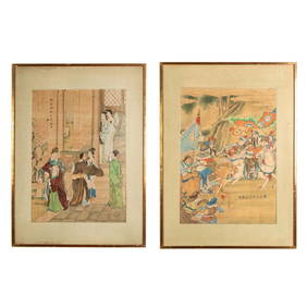
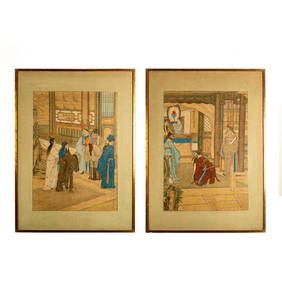
Two Original Qing Dynasty Ink and Color on Silk PaintingsLion and Unicorn4.7(1.9k)See Sold PriceMar 12, 2024
Two Original Qing Dynasty Ink and Color Silk PaintingsLion and Unicorn4.7(1.9k)See Sold PriceMar 12, 2024
Galliae Regionis Nova Descriptio Hand Colored Map of France on Laid Paper, Ca. 16th Century, H 10" WDuMouchelles4.6(833)See Sold PriceMar 15, 2024