

Popular Searches
Popular Searches

8 Tennessee Military & Survey Maps
You May Also Like


Similar Sale History
Sold

Sold


Sold

Sold

Sold
![[MAPS] Military Survey of Australia: Wallerawang & Bathurst (1 of 3)](https://p1.liveauctioneers.com/8597/296734/157735920_1_x.jpg?height=282&quality=70&version=1690170365)
Sold


![[Ordnance Survey]. 8 1950s maps S.E. Asia (1 of 1)](https://p1.liveauctioneers.com/410/19007/6434163_1_x.jpg?height=282&quality=70)
Sold

Sold

Sold

Sold

Sold


Sold

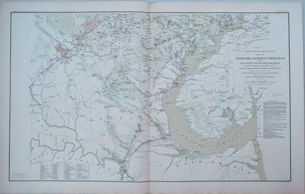
1893 Civil War Map of Northern Virginia -- Sheet 2. Survey for Military Defenses Map of NortheasternTitle: 1893 Civil War Map of Northern Virginia -- Sheet 2. Survey for Military Defenses Map of Northeastern Virginia and Vicinity of Washington [Plate VII] Cartographer: US War Department Year / Place
Sold

Sold

Sold

Sold

Sold


Upcoming Sales
View All


TOP