ATLAS of ANTIENT GEOGRAPHY by SAMUEL BUTLER 1843John McInnis Auctioneers,LLC4.5(505)See Sold PriceFeb 24, 2024
18TH C. ANTIQUE MAP: FRENCH & INDIAN WAR, FRAMEDThomaston Place Auction Galleries4.4(394)See Sold PriceFeb 24, 2024
Rand McNally Railroad Map Cabinet w/ 21 Railroad MapsRail & Road Auctions4.6(165)See Sold PriceMar 08, 2024
Keith Haring - Ink on New York Map, Best Buddies, Inscribed, Signed, and DatedSapphire Auction Gallery4.1(67)See Sold PriceMar 02, 2024
LATE 17TH C. FRENCH MAP OF THE NEW WORLD BY ALEXIS-HUBERT JAILLOT (1632-1712)Thomaston Place Auction Galleries4.4(394)See Sold PriceFeb 24, 2024
Central Railroad of New Jersey Map of Sandy Hook Route-ca. 1903JM Hobby Supply and Railroad Artifact Auctions4.4(127)See Sold PriceFeb 24, 2024
Lot of Six Mixed Atlas Box Cars-HO Scale-New in BoxJM Hobby Supply and Railroad Artifact Auctions4.4(127)See Sold PriceFeb 25, 2024
Rand McNally/Santa Fe Railroad Map of Iowa-1912JM Hobby Supply and Railroad Artifact Auctions4.4(127)See Sold PriceFeb 24, 2024
NICOLAES VISSCHER (NETHERLANDS, 1618-1709) MAP OF THE NEW WORLDThomaston Place Auction Galleries4.4(394)See Sold PriceFeb 24, 2024
17TH C. WORLD MAP BY NICOLAES VISSCHER (NETHERLANDS, 1618-1709)Thomaston Place Auction Galleries4.4(394)See Sold PriceFeb 24, 2024
Lot of Six Mixed Atlas Cabooses-HO Scale-New in BoxJM Hobby Supply and Railroad Artifact Auctions4.4(127)See Sold PriceFeb 25, 2024
Sold8 Books: Map reference, cartographic & US history.[Reference/Historic Geography] 8 Titles. 4to-folio. Hardcover 7 in dj, mostly good to very good. ++ Lez Smart. MAPS THAT MADE HISTORY. (Kew, Richmond, Surrey): National Archives, (2004). ++ Peter BarbSee Sold Price
Sold(8) Books on MapsIncludes "Animal and Maps" ©1969 by Wilma George, "Antique Maps and Their Cartographers"©1970 by Raymond Lister, "Maps, A Historical Survey of Their Study and Collecting"© 1972 bySee Sold Price
Sold1895 8 Book Lot Cloth Binding Hunting George Washington1895 8 Book Lot Cloth Binding Hunting George Washington Europe Illustrated MAPS A unique collection of 8 rare late 19th century and early 20th century cloth bound books ranging in topics from duck shoSee Sold Price
SoldNative Americana (8) BooksGroup of eight books of Native Americana. Many illustrations. Includes: 1) The Nez Perces; Tribalmen of the Columbian Plateau by Haines. 1955, first edition with unclipped dust jacket. 2) Indian FishiSee Sold Price
Sold8 BOOK LOT BY AND RELATED TO JRR TOLKIEN- LOT OF 88 BOOK LOT BY AND RELATED TO JRR TOLKIEN- LOT OF 8 BOOKS INCLUDING FELLOWSHIP OF THE RING (HARDCOVER, HOUGHTON MIFFLIN, FOURTEENTH PRINTING, SOME FOXING ON TOP AND FADING ON DUST JACKET). RETURN OF THSee Sold Price
Sold1874 Hand Drawn Book of Maps1874 Hand Drawn Book of Maps Albany NY work book with 44 hand drawn maps and text by John Bell, 1874. Cover is use worn, otherwise VGC. Book is 7" x 8 1/2" Shipping: Domestic: Flat-rate of $15.00See Sold Price
Sold8 BOUND BOOKS RELATED TO WHALING AND MARITIMEHISTORY TO INCLUDE HISTORY OF AMERICAN WHALE FISHERY BY ALEXANDER STARBUCK, 1878, SLIGHT DAMAGE TO SPINE. BULLETIN OF THE U.S. FISH COMMISSION, VOLUME XVI, 1896, GOOD CONDITION WITH PULL OUT MAPS ANDSee Sold Price
SoldLarge Apollo 14 Landmarks Map Book For TrainingLarge set of Apollo 14 Lunar Landmarks maps used in training at the KSC simulators, and this one probably used by Stuart Roosa. Consists of 8 different 19"x 19" color glossy photos of the lunar surfacSee Sold Price
SoldBook Illustration Map of Canada and North America cBook illustration map of showing part of North America with Canada and parts of New England and New York, with modern hand coloring, measuring 8 by 11 inches.See Sold Price
Sold3 Vols: ATLAS GEOGRAPHUS + AMERICAN UNIVERSAL...[Books containing Maps] 2 Titles (3 Vols). ++ ATLAS GEOGRAPHUS:… 1 Vol only (Asia). In the Savoy: Printed by John Nutt;…[et. al.], 1712. [1]-[3], iv-viii, *1-*8, [1]-851pp. 15 (of 20) plates/foldoSee Sold Price
SoldGroup of 20 antique (late 1800s) Book Plates and mapsLargest is 8.75x11. All are bagged and boarded. Pages from Abbotts Civil War.See Sold Price
Sold2 18th/19th C United States Maps1.) 1831 Map of the Eclipse of Feb 12th in its Passage Across the United States. Published by Gray and Bowen. 9" high x 8-3/4" wide. Cut from book. 2.) 1797 United States map. Published by J. Wilkes.See Sold Price
Sold3 ANTIQUE EUROPEAN WHITE LEATHER BOUND BOOKS WITH3 ANTIQUE EUROPEAN WHITE LEATHER BOUND BOOKS WITH ETCHINGS AND MAPS. MARKED INSIDE FROM MALCOLM FORBES ESQ. LIBRARY, THE BOOKS ARE DATED 1706, 1714 & 1730. 13 1/8" H X 8 1/2" W (TK)See Sold Price
SoldThe History of the War with Russia Maps, 1854Map: War with Russia with Tallis Maps,1854 (vol.1.) Cartographer: H Tyrrell and J Tallis Date: 1854 Origin: London Size: 12.8 x 9.6 inches for majority of maps A magnificent book on the War with RussiSee Sold Price
SoldSir Walter Raleigh's History of the World, 1634Raleigh, Walter. THE HISTORIE OF THE WORLD. IN FIVE BOOKS. [London, 1634.] 13.25" x 8.25". Additional engraved title. [32, *of 66 prelims], 184, 181-555, [1], 512, 517-669, [29, *of 55] pp. + 6 doubleSee Sold Price
1890 Excelsior Dime Vest Pocket Map of New York CityCirca 1890 Antique Map of New York City; "EXCELSIOR DIME VEST POCKET CITY MAPS - NEW YORK". Published by M. J. Ivers & Co. of Fulton St., New York. Approximate map size is 12" x 8-3/4"...a nice frameaSee Sold Price
SoldA Series of Eight Antique Books8 volumes, De Nederlandsche Stad- en Dorp-descriptor, Lieve van Ollefen & R. Bakker, complete with all maps and prints, 1793/1801, bound in leatherSee Sold Price
SoldCartographer's Original Manuscript MapCartographer's Original Manuscript Map Lake Pochartrain. (Found in a bound volume of Epsy's Weather Maps ca. 1840.)x Measures 10 7/8" x 8.5". Left corner torn away. Unframed, loose and not glued or moSee Sold Price
Sold1884 Captain John Smith Works maps New England VirginiaHard bound. Printed in England in 1884 Maps with some acid free tape repairs. Back cover is almost detached. Size 5 3/4 by 8" 982 pages Please note that this lot has a confidential reserve. When you lSee Sold Price
SoldAntique Leather Bound BookTitled universal History, Vol XIII, marbleized front and back cover, illustrated with maps, cuts, notes and tables, no date found, measures cover app 8 by 5 inches, 2 inches thick. Collectible, historSee Sold Price
SoldMap of North America, 1797Ca. late 18th c. engraved map, on laid paper. "A New Map of North America Shewing all the New Discoveries, 1797." Sheet 9.5" x 8.25". From Morse's Gazetteer of America.See Sold Price
SoldDutch Bible 1688 by Hendrick and Jacob Keur w/ Map17th Century Dutch Bible. Tooled leather folio edition with deeply rolled borders finished with 8 bronze corner pieces and original bronze closures. Has large map with gret detail. "Dordrecht, HendricSee Sold Price
SoldThousand and One Nights McRae Illust 8 volsMathers, E. Powys (ed.), illustrated by Roderick McRae, The Book of The Thousand Nights and One Night, complete in 8 volumes, 1930, Dingwall-Rock, hardcover, 8vos., decorative blue cloth, teg.See Sold Price
SoldEarly 18th C Handcolored Map Russia MoscoviaNicely handcolored map of Russia Sive Moscovia, text on verso. Fine, measures 8.5 x 6.5". Reserve: $50.00 Shipping: Domestic: Flat-rate of $5.00 to anywhere within the contiguous U.S. International: FSee Sold Price
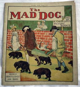
R. Caldecott & Dr. Goldsmith Elegy Death Mad Dog c1900 1st Edition IllustratedLuis Porretta Fine Arts4.3(10)See Sold PriceMar 02, 2024
SAMUEL FOOTE The Great Panjandrum c1900 Illustrated Children's Books 1st EditionLuis Porretta Fine Arts4.3(10)See Sold PriceMar 02, 2024
ANNIE BEAN Breath of a ROSE 1916 1st Edition Rare Poetry Book Early CaliforniaLuis Porretta Fine Arts4.3(10)See Sold PriceMar 02, 2024
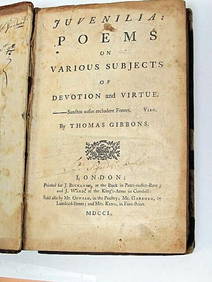
Thomas Gibbons Juvenalia 1750 Very Rare 1st Edition Full CalfLuis Porretta Fine Arts4.3(10)See Sold PriceMar 02, 2024
The FARMERS MAGAZINE c1812 1st Edition Calf Binding Engravings SCARCE!Luis Porretta Fine Arts4.3(10)See Sold PriceMar 02, 2024
OLIVER GOLDSMITH c1778 Rare Pamphlet Poem The TravellerLuis Porretta Fine Arts4.3(10)See Sold PriceMar 02, 2024
ARTHUR MILLER Death Of A Salesman 1st First Edition 1949 vgcLuis Porretta Fine Arts4.3(10)See Sold PriceMar 02, 2024
MARGARET LAURENCE A Jest Of God 1966 1st First Edition Dust Wrapper Near Fine!Luis Porretta Fine Arts4.3(10)See Sold PriceMar 02, 2024
HAROLD ROBBINS Dream Merchants 1949 1st First Edition With Dust Wrapper vgcLuis Porretta Fine Arts4.3(10)See Sold PriceMar 02, 2024
Peter Stoyan (Stoyanoff) (1900-1979) Canadian Listed Engraving 1940 PortraitLuis Porretta Fine Arts4.3(10)See Sold PriceMar 02, 2024
Théo Tobiasse (1927 - ) ca1970 Original Signed Lithograph 11" x 8"Luis Porretta Fine Arts4.3(10)See Sold PriceMar 02, 2024
Mary Blaize Elegy Glory Sex c1900 1st Edition IllustratedLuis Porretta Fine Arts4.3(10)See Sold PriceMar 02, 2024
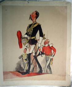
JOSEPH MARTIN KRONHEIM - "Captain Of The Blues" Early Colore Printing MilitaryLuis Porretta Fine Arts4.3(10)See Sold PriceMar 02, 2024
General Books - Four Maps of Great Britain Designed by Matthew Paris About A.D. 1250TimeLine Auctions Ltd.4.6(184)See Sold PriceMar 08, 2024
Universal World History Illustrated Bks 8, 1929The Benefit Shop Foundation Inc.4.3(3k)See Sold PriceMar 06, 2024
Battle of the Nile: Disposition of the English & French Fleets, at the Commencement of the Action,Trillium Antique Prints & Rare Books4.5(33)See Sold PriceFeb 24, 2024
Linnaeus - Pair: Bengal & Golden OriolesTrillium Antique Prints & Rare Books4.5(33)See Sold PriceFeb 24, 2024
Linnaeus - Passerina or Little OwlTrillium Antique Prints & Rare Books4.5(33)See Sold PriceFeb 24, 2024
Audubon - 8 Quadruped LithographsTrillium Antique Prints & Rare Books4.5(33)See Sold PriceFeb 24, 2024