ATLAS of ANTIENT GEOGRAPHY by SAMUEL BUTLER 1843John McInnis Auctioneers,LLC4.5(505)See Sold PriceFeb 24, 2024
18TH C. ANTIQUE MAP: FRENCH & INDIAN WAR, FRAMEDThomaston Place Auction Galleries4.4(393)See Sold PriceFeb 24, 2024
Rand McNally Railroad Map Cabinet w/ 21 Railroad MapsRail & Road Auctions4.6(165)See Sold PriceMar 08, 2024
Keith Haring - Ink on New York Map, Best Buddies, Inscribed, Signed, and DatedSapphire Auction Gallery4(67)See Sold PriceMar 02, 2024
LATE 17TH C. FRENCH MAP OF THE NEW WORLD BY ALEXIS-HUBERT JAILLOT (1632-1712)Thomaston Place Auction Galleries4.4(393)See Sold PriceFeb 24, 2024
Central Railroad of New Jersey Map of Sandy Hook Route-ca. 1903JM Hobby Supply and Railroad Artifact Auctions4.4(127)See Sold PriceFeb 24, 2024
Lot of Six Mixed Atlas Box Cars-HO Scale-New in BoxJM Hobby Supply and Railroad Artifact Auctions4.4(127)See Sold PriceFeb 25, 2024
Rand McNally/Santa Fe Railroad Map of Iowa-1912JM Hobby Supply and Railroad Artifact Auctions4.4(127)See Sold PriceFeb 24, 2024
NICOLAES VISSCHER (NETHERLANDS, 1618-1709) MAP OF THE NEW WORLDThomaston Place Auction Galleries4.4(393)See Sold PriceFeb 24, 2024
17TH C. WORLD MAP BY NICOLAES VISSCHER (NETHERLANDS, 1618-1709)Thomaston Place Auction Galleries4.4(393)See Sold PriceFeb 24, 2024
Lot of Six Mixed Atlas Cabooses-HO Scale-New in BoxJM Hobby Supply and Railroad Artifact Auctions4.4(127)See Sold PriceFeb 25, 2024
Sold7 SMALL MAPS, CAPTAIN COOK & POLAR PROJECTIONGroup of seven hand colored and uncolored small maps including Alain Manesson Mallet polar projection map, circa 1683, four maps featuring information on Captain Cook, and two small maps of the TropicSee Sold Price
Asia.Reserve Reduced! Title/Content of Map: Asia. Date: c1800 Cartographer: ANONYMOUS Size: 7.3Height - 8.75Width 19. Map from a good English geography. Polar projection. Quite detailed for a small map. CeSee Sold Price
Asia.Title: Asia. Publication Date: 1800 ca. Cartographer: ANONYMOUS Publisher: Size: 7.3Height - 8.75Width 19. Map from a good English geography. Polar projection. Quite detailed for a small map. CenterfoSee Sold Price
Soldc.1781 7 Maps-Captain Cook Voyagesc. 1781, Seven Maps relating to the Voyages of Captain James Cook, Choice Very Fine to Extremely Fine. Published in London by Alexander Hogg for use as illustrations in books describing Capt. James CoSee Sold Price
South America from the Best Authorities.Title/Content of Map: South America from the Best Authorities. Date Printed: 1790 Cartographer: KITCHIN, THOS. Size: 7.3X9 Illustration map on polar projection. From Guthrie's New geographical, historSee Sold Price
South America from the Best Authorities.Title/Content of Map: South America from the Best Authorities. Date Printed: 1790 Cartographer: KITCHIN, THOS. Size: 7.3X9 Illustration map on polar projection. From Guthrie's New geographical, historSee Sold Price
South America from the Best Authorities.Title: South America from the Best Authorities. Cartographer: KITCHIN, THOS. Publication Date: 1790 Publisher: DILLY AND ROBINSON Size: 7.3 X 9 Illustration map on polar projection. From Guthrie's NewSee Sold Price
South America from the Best Authorities.Title: South America from the Best Authorities. Publication Date: 1790 Cartographer: KITCHIN, THOS. Dimensions: 7.3Height - 9Width Publisher: DILLY AND ROBINSON Illustration map on polar projection. FSee Sold Price
Tallis/Rapkin: Antique Map of Captain Cook's VoyageTitle/Content of Map: 'The World on Mercator's Projection shewing the voyages of Captain Cook around the World' The track's of Cook's first, second and third voyages are shown, along with dates. DateSee Sold Price
Polar.- Captain Cook.- Bell (Andrew) Geography A Map ofPolar.- Captain Cook.- Bell (Andrew) Geography A Map of the World in Three Sections, Describing the Polar Regions to the Tropics In Which Are Traced the Tracts of Lord Mulgrave and Captain Cook TowardSee Sold Price
SoldAfrica from the Best Authorities.Title/Content of Map: Africa from the Best Authorities. Date: 1790 Cartographer: KITCHIN, T. Size: 7.25X8.8 Illustration map from Guthrie's Geography. Rather detailed. Polar projection Please note thaSee Sold Price
Asia.Title: Asia. Publication Date: 1802 Cartographer: RALPH, W. Publisher: Aaron Arrowsmith Size: 9.25Height - 7.1Width From Arrowsmith's Maps. From Brooke's General Gazetteer improved… Polar projectionSee Sold Price
AsieTitle/Content of Map: Asie Date: 1836 Cartographer: MONIN, C. V./A. R. FREMIN Size: 7.75X9.75 Map from Monin et Fremin's Atlas Universel de cinq parties du Monde. Polar projection. Few spots Please noSee Sold Price
The World: Shewing the Voyages of Captain Cook 1849 MapThe World. 'Shewing the Voyages of Captain Cook'. Tallis/rapkin 1849 Old Map. Title/content of Map: 'the World on Mercator's Projection Shewing the Voyages of Captain Cook Around the World' the Track'See Sold Price
AfricaTitle/Content of Map: Africa Date Printed: 1812 Cartographer: KNEASS, W. Size: 7.25x9.25 "From Arrowsmith's Map of Africa W. Kneass sc. Philad." Polar projection. Nice example. Please note that this lSee Sold Price
SoldMap of the World, Bell, 1778Map, double hemisphere, a Map of the World in three Sections, London 1778, Describing the Polar Regions to the tropics which trace the travels of Lord Mulgrave and Captain Cook, the map depicts theirSee Sold Price
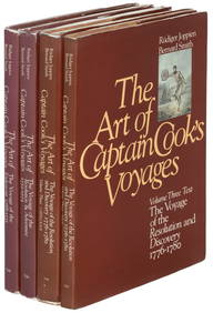
Cook (Captain James) The Three VoyagesCook (Captain James) The Three Voyages,7 vol., folding engraved map, portrait and 24 aquatint plates, occasional foxing, contemporary half calf over marbled boards, spines gilt, slight scuffinSee Sold Price
SoldCook (Captain James) The Three VoyagesCook (Captain James) The Three Voyages,7 vol., folding engraved map, portrait and 24 aquatint plates, occasional foxing, contemporary half calf over marbled boards, spines gilt, slight scuffinSee Sold Price
Sold(Captain James) The Three Voyages, 7 vol., folding-. Cook (Captain James) The Three Voyages, 7 vol., folding engraved map, portrait and 24 aquatint plates, spotting, original boards, uncut, some unopened, a few covers becoming loose, spines wSee Sold Price
THE WORLD. 'Shewing the voyages of Captain Cook'. TALLIS/RAPKIN 1851 old mapCAPTION PRINTED BELOW PICTURE: 'The World on Mercator's Projection shewing the voyages of Captain Cook around the World' The track's of Cook's first, second and third voyages are shown, along with datSee Sold Price
THE WORLD. 'Shewing the voyages of Captain Cook'. TALLIS/RAPKIN 1851 old mapCAPTION PRINTED BELOW PICTURE: 'The World on Mercator's Projection shewing the voyages of Captain Cook around the World' The track's of Cook's first, second and third voyages are shown, along with datSee Sold Price
THE WORLD. 'Shewing the voyages of Captain Cook'. TALLIS/RAPKIN 1849 old mapTITLE/CONTENT OF MAP: 'The World on Mercator's Projection shewing the voyages of Captain Cook around the World' The track's of Cook's first, second and third voyages are shown, along with dates. DATESee Sold Price
Sold[Map] The World on Mercator's Projection Shewing the[Map] Tallis, J. and J. Rapkin. The World on Mercators Projection Shewing the Voyages of Captain Cook Round the World. [London, 1851]. Hand colored with a decorative border and vignettes showing the 3See Sold Price
SoldMaps, Wilkinson, Sidney Hall, Africa(Lot of 2) Framed maps, Wilkinson, ''A New Mercator's Charts, drawn from the Latest Discoveries,'' London, 1800, map of the World in Mercator' projection, showing the tracks of Captain Cook (1776-1779See Sold Price
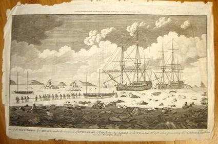
ALEXANDER HOGG ca1790 Engraving Captain Mulgrave Ships Ice Bound Cpt CookLuis Porretta Fine Arts4.3(10)See Sold PriceMar 02, 2024
Carey, pub. 1796 - A Chart of the West IndiesTrillium Antique Prints & Rare Books4.5(32)See Sold PriceFeb 24, 2024
Carey, pub. 1796 - Map of the State of MarylandTrillium Antique Prints & Rare Books4.5(32)See Sold PriceFeb 24, 2024
Carey, pub. 1796 - Map of GeorgiaTrillium Antique Prints & Rare Books4.5(32)See Sold PriceFeb 24, 2024
Carey, pub. 1796 - Map of The State of South CarolinaTrillium Antique Prints & Rare Books4.5(32)See Sold PriceFeb 24, 2024
Carey, pub. 1796 - Map of KentuckyTrillium Antique Prints & Rare Books4.5(32)See Sold PriceFeb 24, 2024
Carey, pub. 1796 - Map of the Tennassee State formerly part of North Carolina (Tennessee)Trillium Antique Prints & Rare Books4.5(32)See Sold PriceFeb 24, 2024
1704 DESCRIPTION OF ALL THE SEATS OF THE PRESENT WARS OF EUROPE antique w/ MAPSJasper524.5(9.9k)See Sold PriceFeb 27, 2024
AFRICA. Shooting a Leopard eating Antelope (Field Sports- Edward Orme) 1814Jasper524.5(9.9k)See Sold PriceFeb 28, 2024
AFRICA. Lions waiting for Prey (Field Sports- Edward Orme) 1814 old printJasper524.5(9.9k)See Sold PriceFeb 28, 2024
SOUTH AFRICA. Shooting an African Buffalo. Top hat. (Edward Orme) 1814 printJasper524.5(9.9k)See Sold PriceFeb 28, 2024
Blackie (Pub) 1882 Folio Map. World on Mercators ProjectionAlbion Auctions4.6(341)See Sold PriceMar 01, 2024
Book Of North American Birds by The Readers DigestRapid Estate Liquidators and Auction Gallery4.5(1.1k)See Sold PriceFeb 27, 2024
Coca Cola Wrapping Paper Gift Bags Banners ClothRapid Estate Liquidators and Auction Gallery4.5(1.1k)See Sold PriceFeb 29, 2024


![[Map] The World on Mercator's Projection Shewing the (1 of 1)](https://p1.liveauctioneers.com/928/150426/75971118_1_x.jpg?height=282&quality=70&version=1568819120)