ATLAS of ANTIENT GEOGRAPHY by SAMUEL BUTLER 1843John McInnis Auctioneers,LLC4.6(504)See Sold PriceFeb 24, 2024
18TH C. ANTIQUE MAP: FRENCH & INDIAN WAR, FRAMEDThomaston Place Auction Galleries4.4(389)See Sold PriceFeb 24, 2024
Rand McNally Railroad Map Cabinet w/ 21 Railroad MapsRail & Road Auctions4.6(165)See Sold PriceMar 08, 2024
Keith Haring - Ink on New York Map, Best Buddies, Inscribed, Signed, and DatedSapphire Auction Gallery4.1(67)See Sold PriceMar 02, 2024
LATE 17TH C. FRENCH MAP OF THE NEW WORLD BY ALEXIS-HUBERT JAILLOT (1632-1712)Thomaston Place Auction Galleries4.4(389)See Sold PriceFeb 24, 2024
Central Railroad of New Jersey Map of Sandy Hook Route-ca. 1903JM Hobby Supply and Railroad Artifact Auctions4.4(126)See Sold PriceFeb 24, 2024
Lot of Six Mixed Atlas Box Cars-HO Scale-New in BoxJM Hobby Supply and Railroad Artifact Auctions4.4(126)See Sold PriceFeb 25, 2024
Rand McNally/Santa Fe Railroad Map of Iowa-1912JM Hobby Supply and Railroad Artifact Auctions4.4(126)See Sold PriceFeb 24, 2024
NICOLAES VISSCHER (NETHERLANDS, 1618-1709) MAP OF THE NEW WORLDThomaston Place Auction Galleries4.4(389)See Sold PriceFeb 24, 2024
17TH C. WORLD MAP BY NICOLAES VISSCHER (NETHERLANDS, 1618-1709)Thomaston Place Auction Galleries4.4(389)See Sold PriceFeb 24, 2024
Lot of Six Mixed Atlas Cabooses-HO Scale-New in BoxJM Hobby Supply and Railroad Artifact Auctions4.4(126)See Sold PriceFeb 25, 2024
Sold6 maps: California, Pellacata, Dunkirk...[Africa/India/Baja California] 6 Maps. Tape to edges of sheets. ++ Map centered around Baja California, labeled “California." Includes the lower portion of the Rio Grande. James Burney, 1803. In marSee Sold Price
SoldUSA 1903 Lot of 6 State Maps. California, Utah, NevadaPlus Washington, Colorada and Arizona/New Mexico. Lithograph Maps Published 1903 by Adam & Charles Black, Edinburgh & London for "Encyclopaedia Brittannica" Tenth Edition. Centre fold as published. PaSee Sold Price
SoldSet of 6 United States West Coast maps of CaliforSet of 6 United States West Coast maps of California, published at Washington, D.C., U.S. Department of Commerce Environmental Science Services Administration Coast and Geodetic Survey, some with plotSee Sold Price
1874 Mitchell Map of California -- County Map of theTitle/Content of Map: 1874 Mitchell Map of California -- County Map of the State of California Cartographer: S. Mitchell Size: 21.2 x 14.6 in. An excellent large map of California with color coded couSee Sold Price
SoldFORBES, Alexander. California.... London, 1839.148. FORBES, Alexander. California: A History of Upper and Lower California.... London, 1839. 10 uncolored lithograph plates, folding lithographic map of California with 6 insets of ports. 8vo, originSee Sold Price
Sold1703 Scherer - World Map [California as an Island]Title: World Map [without title] "Map maker: Heinrich Scherer, Atlas Marianus" "Place and Year: Munich, 1703" "Dimensions: 23.6 x 35.5 cm (9.3 x 14 in)" "Technique: Copperplate engraving" "Coloring: USee Sold Price
Sold1690's North and South America Map California as ITwo Beautiful 17th Century map of North America and South America. Each about 8 x 6", Dated 1690, two truly historic beautifully detailed very early maps. One is titled "L'AMERIQUE Septentrionale." inSee Sold Price
Sold1690's North and South America Map California asTwo Beautiful 17th Century map of North America and South America. Each about 8 x 6", Dated 1690, two truly historic beautifully detailed very early maps. One is titled "L'AMERIQUE Septentrionale." inSee Sold Price
Sold1690's North and South America Map California asTwo Beautiful 17th Century map of North America and South America. Each about 8 x 6", Dated 1690, two truly historic beautifully detailed very early maps. One is titled "L'AMERIQUE Septentrionale." inSee Sold Price
SoldFowler and Moyer topographical map California Pa.Artist: Fowler, T.M., and James B. Moyer Title: California, Washington County, Pennsylvania Date: 1902 Medium: chromolithograph Dimensions: 10.2 x 18.6 inches Edition Number: Signature: Printed in plaSee Sold Price
Soldc. 1706-28 World Map: FRANCIS DRAKES VOYAGEHistoric MapsCalifornia is Depicted as an Island c. 1706-28, "F. DRAAKX SCHIP-VAART DOOR DE STRAAT EN ZUYD ZEE..." by Pieter Vander Aa, Leyden, Near Mint. This 6" x 9", handcolored map of theSee Sold Price
SoldMitchell: Map of California & Territories, 1854Map: Hand Colored Map Of California And The Territories Maker: Samuel Augustus Mitchell Date: 1854 Size: Approx. 6.5x8 inches Hand colored. From the 1854 Mitchell's School Atlas by Samuel Augustus MiSee Sold Price
Sold1938 R Taylor White Pictorial Map of CaliforniaTitle/Content of Map: 1938 R Taylor White Pictorial Map of California -- California Date Printed: 1938, Boston Cartographer: Ruth Taylor White Size: 11.6 x 8.5 in. This is Ruth Taylor White's charmingSee Sold Price
Sold1869 Mitchell Map of CaliforniaTitle/Content of Map: 1869 Mitchell Map of California -- County Map of the State of California Date Printed: 1869, Philadelphia Cartographer: S. Mitchell Size: 21.2 x 14.6 in. An excellent large map oSee Sold Price
Mitchell: Antique Map of California, 1878Title/Content of Map: 1878 Mitchell Map of California -- County Map of the State of California Date Printed: 1878, Philadelphia Cartographer: S. Mitchell Size: 21.2 x 14.6 in. An excellent large map oSee Sold Price
Mitchell: Antique County Map of California, 1878Title/Content of Map: 1878 Mitchell Map of California -- County Map of the State of California Date Printed: 1878, Philadelphia Cartographer: S. Mitchell Size: 21.2 x 14.6 in. An excellent large map oSee Sold Price
Mitchell: Antique Map of California, 1869Title/Content of Map: 1869 Mitchell Map of California -- County Map of the State of California Date Printed: 1869, Philadelphia Cartographer: S. Mitchell Size: 21.2 x 14.6 in. An excellent large map oSee Sold Price
Mitchell: Antique Map of California, 1874Title/Content of Map: 1874Mitchell Map of California -- County Map of the State of California Date Printed: 1874, Philadelphia Cartographer: S. Mitchell Size: 21.2 x 14.6 in. An excellent large map ofSee Sold Price
1876 Mitchell Map of California -- County Map of theTitle/Content of Map: 1876 Mitchell Map of California -- County Map of the State of California Date: 1876 Philadelphia Cartographer: S. Mitchell Size: 21.2 x 14.6 in. An excellent large map of CaliforSee Sold Price
Sold1874 Mitchell Map of California -- County Map of theTitle: 1874 Mitchell Map of California -- County Map of the State of California Cartographer: S. Mitchell Year / Place: 1874, Philadelphia Map Dimension (in.): 21.2 x 14.6 in. An excellent large map oSee Sold Price
SoldZachary Taylor - California and New Mexico 1850Taylor, Zachary Description:976 pp. Illustrated with 7 maps, 6 of them folding. 8¾x5¼, original half sheep & marbled boards, spine lettered in gilt. House Ex. Doc. 17, 31st Congress, 1st Session. ImSee Sold Price
Sold1690's North and South America Map of CaliforniaSubtitle: Description:Two Beautiful 17th Century map of North America and South America. Each about 8 x 6", Dated 1690, two truly historic beautifully detailed very early maps. One is titled "L'AMERIQSee Sold Price
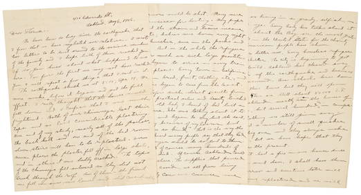
SoldZachary Taylor - California and New Mexico 1850Title: Message of the President of the United States, Communicating information...in relation to California and New Mexico. (caption title) Author: Taylor, Zachary Description: 952 pp. With 7 maps, 6See Sold Price
1876 Mitchell Map of California -- County Map of theTitle: 1876 Mitchell Map of California -- County Map of the State of California Cartographer: S. Mitchell Year/Place: 1876 Philadelphia Size: 21.2 x 14.6 in. Description: An excellent large map of CalSee Sold Price
Olympic by Schulz & Fischer Sterling Silver Ice Cream Spoon GW BC 6" CaliforniaMynt Auctions4.6(689)See Sold PriceFeb 24, 2024
VARIOUS ARTISTS [BRITISH TRAVEL GUIDES]. Group of 6 map booklets and flyers. 1930s.Swann Auction Galleries4.4(69)See Sold PriceFeb 29, 2024
Cleopatra by Schulz and Fischer Sterling Silver Regular Fork 6 3/4" CaliforniaBidhaus4.3(757)See Sold PriceMar 02, 2024
Francis McNally - Antique Map of California & MinnesotaProverde Auctions4.3(3)See Sold PriceFeb 28, 2024


![1703 Scherer - World Map [California as an Island] (1 of 2)](https://p1.liveauctioneers.com/5584/112867/57947644_1_x.jpg?height=282&quality=70&version=1511920104)


![VARIOUS ARTISTS [BRITISH TRAVEL GUIDES]. Group of 6 map booklets and flyers. 1930s. (1 of 2)](https://p1.liveauctioneers.com/199/319703/171640571_1_x.jpg?height=282&quality=70&version=1707943705)