SoldWilliam Darton, (10) antique mapsWilliam Darton, (10) antique maps, William Darton (British, 19th c.), "The Western Hemisphere or New World", "South America", etc., 12.75"h x 10.5"w (sheet), unframed Provenance: Property from a majorSee Sold Price
SoldMap, Americae Nova Tabula, Guiljelmo BlaeuwAn antique map, titled Americae Nova Tabula. Auct: Cartographer, Guiljelmo Blaeuw, published c.1640. Copperplate engraving of the Western Hemisphere with full color. Carte-figures, featuring ten smallSee Sold Price
SoldFour 17th-18th C. Maps: Desing, Manesson-MallettCollection of four 17th and 18th European maps, Item 1: P. A. Desings map of the western hemisphere. Hand colored copper engraving published in 1741. 6 3/8" H x 5 3/4" W. Items 2 and 3: Two Manesson-See Sold Price
SoldMap: Giuilielmo Blaeuw (1600-1699), "Americae NovaMap: Giuilielmo Blaeuw (1600-1699), "Americae Nova Tabula," c. 1622, copper plate engraving of the Western Hemisphere with full color, featuring ten small panels of native figures along the sides andSee Sold Price
Sold19TH C. F. LUCAS COLOR ENGRAVED MAP OF CONNECTICUTHand-colored engraving "Connecticut" map c. 1822, drawn and published by Fielding Lucas, Jr. of Baltimore (1781- 1854) and engraved by B.T. Welch. Dimensions: (Frame) H 16" x W 19.5" (Sight) H 10.5" xSee Sold Price
SoldCary: Antique Map of the Western Hemisphere, 1806Map: A New Map of America Cartographer: John Cary Place & Date: London / 1806 Size: 20 5/8" x 18 1/4" Condition: original color; light overall age toning; browning on upper margin around centerfold ThSee Sold Price
SoldN. C. Wyeth, Map of Discovery, Eastern & WesternTwo framed vintage prints / maps after N.C. Wyeth. "Map of Discovery, Eastern & Western Hemisphere". Signed and dated in the prints 1927. The images measure 15.5" x 17.75". Framed and matted under glaSee Sold Price
Sold19th c. Schoolgirl map of British IslesSchool girl map of the British Isles titled "Britain by C H." Title surrounded by a ring of roses. Hand colored ink and water color on paper. 11 5/8" H x 9" W. 19th Century. Provenance: Estate of SallSee Sold Price
SoldWater Color and Print Grouping Water color of fishermanWater color of fisherman in the bay. Good color, no foxing. Image measures approx 5"h x 21"w. Also a 19th C woodcut printed map of Rome.See Sold Price
Delahaye: Antique Chart of the Atlantic Ocean, 1750Map: untitled Atlantic chart Cartographer: Delahaye Place & Date: Paris / 1750 Size: 22 1/4" x 19 5/8" Condition: outline color in the Western Hemisphere, the rest in b&w; margins frayed; overall ageSee Sold Price
SoldFramed needlework on linen of the hemispheres titled ÒAFramed needlework on linen of the hemispheres titled ÒA Map of the World, probably late 19th c. 18.5h.x31.5"w."See Sold Price
SoldGin Wood Bottle Model, Art, 19thc JMD-1510919.5" tall, 6" square gin bottle that is an artisan's piece. Constructed of wood parts attached with crude square nails, this piece has had a very experienced quality artist paint nudes in color on twSee Sold Price
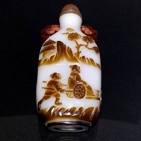
SoldFIVE-COLOR OVERLAY GLASS SNUFF BOTTLE五颜色叠加玻璃鼻烟壶FIVE-COLOR OVERLAY GLASS SNUFF BOTTLE Chinese Glass Snuff BottleChina, 18/19th C., 5 Colors Glass Snuff Bottle , in a flSee Sold Price
SoldWorld Map in Hemispheres 19th CMap: Mapemonde. (World map in hemispheres) Maker: Unknown Origin: French, 19th Century Medium: Original lithograph with hand coloring. Sheet Size: 6 1/4 x 9 inches No Reserve: This lot starts at $1 anSee Sold Price
SoldAmerican Western 19th C. Documents (5)1899 Receipt form, Deer Lodge County, Montana and Certificate of Tax Sale, same. Documents related to 154 acres of land held by Frank O'Hanlan. Printed historical information associated with the documSee Sold Price
SoldCHINESE TWO TONED JADE LIONS PENDANTThe jade of a white and ruby red tone carved as two fu lions playing with a silk ball, one to each side of the plaque matching two distinct tone colors. 19th C. L. 5.7cm (2 1/4 in.)See Sold Price
Sold3 RR LANTERN COLORED CAST/ETCHED GLOBESLOT (3) RAILROAD LANTERN COLORED CAST/ETCHED GLOBES INCL. NEW YORK, LAKE ERIE & WESTERN RAILROAD, 19TH C., H. 5 1/2" - 6"See Sold Price
SoldAMERICAN CARVED EAGLE WALL HANGINGlate 19th c., old color, 13.5”h; 39.5” wing spanSee Sold Price
SoldTRANQUILLO MOLLO ATLASTRANQUILLO MOLLO ATLAS; Thirty-four maps out of an original fifty-two include America, United Kingdom, Australia, etc., Vienna, late 18th/early 19th c.; Most maps with color; 15'' x 20''See Sold Price
SoldTallis, John (Pub) 1852 Map. Western HemisphereSteel Engraved Map with Original Outline Hand Color Published 1852-56 by John Tallis, London for "The Universal Pronouncing Dictionary" by Thomas Wright. Drawn & Engraved by John Rapkin. Centre fold aSee Sold Price
SoldTexas nach den Besten Quellen Map, 19th CMap: Texas nach den Besten Quellen Cartographer: Bibliographischen Instituts. / Radefeld Place & Date: Hildburghausen / 1849/1857 Size: 13 7/8" x 11 1/2" Condition: original outline color The scarce sSee Sold Price
SoldGrp: 5 Maps of Brazil Blaeu Bellin KitchinGroup of five 17th to 19th c. maps of South America and the Caribbean. Thomas Kitchin (1719-1784) map of the Caribbean, "A New Map of the Caribbee Islands in America 1761" London, 1761; Jacques-NicolaSee Sold Price
SoldGrp: 5 Maps of Brazil Blaeu Bellin KitchinGroup of five 17th to 19th c. maps of South America and the Caribbean. Thomas Kitchin (1719-1784) map of the Caribbean, "A New Map of the Caribbee Islands in America 1761" London, 1761; Jacques-NicolaSee Sold Price
Sold19th C color and ink on silk by a tang artist19th C color and ink on silk by a tang artist . H:17.5" W:24.5" comes with letter of authenticity.See Sold Price
19thC Tibetan or Mongolian Silk Thangka, 19" x 12.5"The Buddha Gallery4.4(29)See Sold PriceMar 13, 2024
19thc Colton Map, Comparitive Size of Lakes & IslandsConnoisseur Auctions3.9(335)See Sold PriceFeb 24, 2024
ANTIQUE CHINESE PEKING GLASS SNUFF BOTTLE PEOPLES PAGODA 19TH CNoble House Collection Gallery4.5(121)See Sold PriceFeb 28, 2024
Pair of 19th Century Temple Jars, Lidded, Chinoiserie Foo Dog Finials, 19th C.Jasper524.5(9.8k)See Sold PriceFeb 28, 2024
Early West Anatolian Fragment Anatolia 4 ft. 5 in. x 5 ft. 7 in.Bonhams4.1(315)See Sold PriceFeb 26, 2024
NORTH & WEST AFRICA. Gold Coast (Ghana) Slave Coast. Tribal names 1890 mapJasper524.5(9.8k)See Sold PriceFeb 28, 2024
Western Africa by Edward Weller. Early British/French settlements 1860 old mapJasper524.5(9.8k)See Sold PriceFeb 28, 2024
Western Africa by Edward Weller. Early British/French settlements 1859 old mapJasper524.5(9.8k)See Sold PriceFeb 28, 2024
19th C. Hermes Intaglio, Athena Cameo, Gold PendantArtemis Fine Arts4.8(1.4k)See Sold PriceFeb 26, 2024
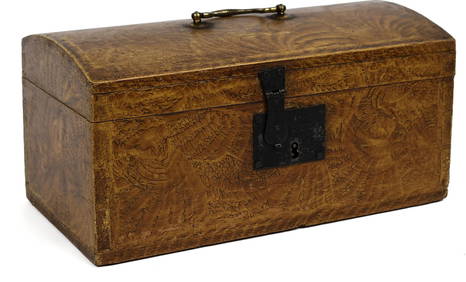
19TH C. AMERICAN SPONGE DECORATED MINIATURE BOX.William Smith Auctions4.6(146)See Sold PriceMar 06, 2024
19th C. European Figural of Virgin Mary Nursing JesusArtemis Fine Arts4.8(1.4k)See Sold PriceFeb 26, 2024
19th C Chinese Famille Verte and Iron Red Bowl.Clarke Auction Gallery4.5(551)See Sold PriceMar 10, 2024