Sold4 Maps incl: MAPPE-MONDE EN DEUX HEMISPHERES...[World/Maryland/Virginia] 4 Maps. ++ MAPPE-MONDE EN DEUX HEMISPHERES, L’ORIENTAL ET L’;OCCIDENTAL. [Paris]: Bonne, 1781. Recognizable as Alaska, with large inlet of water at south-center. Shows thSee Sold Price
SoldWorld map: ''Mappemonde en Deux Hemispheres,'' 18[World Map]. A. Brue. Mappemonde En Deux Hemispheres... Seconde Edition. Double-page engraved plate, Paris: 1830. Each hemisphere 10 1/4 in. Sheet 20 7/8 x 26 1/4 in. Color outline, embossed stamp lowSee Sold Price
1875 Migeon Map Mappe-Monde en Deux Hemispheres“Mappe-Monde en Deux Hemispheres”, engraved by Migeon and Sengteller, printed by Chez Lacoste. 1875. Measures 18.5 x 13.5. Please note that this lot has a confidential reserve. When you leave a biSee Sold Price
Malte-Brun: Antique Map of World in Hemispheres, 1846Title/Content of Map: 'Mappemonde en Deux Hémisphères' World, Twin Hemispheres. Mexican Texas. Date Printed: c1846 Image Size: Approx 28.0 x 47.5cm, 11 x 18.5 inches (Large); Please note that this iSee Sold Price
SoldMappemonde en Deux Hemispheres Conrad Malte-Brun 1846Antique Map 'Mappemonde en Deux Hemispheres' [World Map in Two Hemispheres] by Conrad Malte-Brun (1775 - 1826) | DATE: c. 1846 | SIZE: Map with borders: Approx. 16" H x 22" W (40.64 x 55.88cm); imageSee Sold Price
Malte-Brun: Antique Map of World, Twin Hemispheres 1846TITLE/CONTENT OF MAP: 'Mappemonde en Deux Hémisphères' Twin Hemispheres. Mexican Texas. DATE PRINTED: c1846 IMAGE SIZE: Approx 28.0 x 47.5cm, 11 x 18.5 inches (Large); Please note that this is a folSee Sold Price
WORLD. Mappemonde. Twin Hemispheres. Mexican Texas.TITLE/CONTENT OF MAP: 'Mappemonde en Deux Hémisphères' Date: c1846 IMAGE SIZE: Approx 28.0 x 47.5cm, 11 x 18.5 inches (Large); Please note that this is a folding map. TYPE: Antique engraved map withSee Sold Price
Antique Map of the World in Twin Hemispheres, 1880TITLE/CONTENT OF MAP: 'Mappemonde en deux Hémisphères; Ancien ou 1er. Continent; Nouveau ou 2me. Continent; Terms Géographiques et signes conventionnels; Golfe (Golfe de Gènes); Péninsule (MoréeSee Sold Price
WORLD. Mappemonde. Twin Hemispheres. Mexican Texas.TITLE/CONTENT OF MAP: 'Mappemonde en Deux Hémisphères' Date: c1846 IMAGE SIZE: Approx 28.0 x 47.5cm, 11 x 18.5 inches (Large); Please note that this is a folding map. TYPE: Antique engraved map withSee Sold Price
World Mappemonde Twin Hemispheres Malte-Brun C1846World Mappemonde Twin Hemispheres Mexican Texas Malte-brun C1846. Title/content of Map: 'mappemonde En Deux Hémisphères' This Map Is Folding Hence the Centrefold Line May Show on the Image Below datSee Sold Price
WORLD. Mappemonde. Twin Hemispheres. Mexican Texas.TITLE/CONTENT OF MAP: 'Mappemonde en Deux Hémisphères' DATE PRINTED: c1846 IMAGE SIZE: Approx 28.0 x 47.5cm, 11 x 18.5 inches (Large); Please note that this is a folding map. TYPE: Antique engravedSee Sold Price
Mappemonde en Deux Hemispheres World Map 2 HemispheresMappemonde en Deux Hemispheres\' | ARTIST: Conrad Malte-Brun | DATE: c. 1846 | SIZE: Map with borders: Approx. 16\" H x 22\" W (40.64 x 55.88cm); image only: Approx. 11\" H x 18.5\" W (28.0 x 47.5cm)See Sold Price
Mappemonde en Deux Hemispheres World Map 2 HemispheresTITLE: 'Mappemonde en Deux Hemispheres' | ARTIST: Conrad Malte-Brun | DATE: c. 1846 | SIZE: Map with borders: Approx. 16" H x 22" W (40.64 x 55.88cm); image only: Approx. 11" H x 18.5" W (28.0 x 47.5cSee Sold Price
SoldF.A. GARNIER TWIN HEMISPHERE WORLD MAP, 1860Map no. 13, titled 'Tableau Spheroidal de la Terre, Ou Mappemonde en Deux Hemispheres.' Inset maps below. Printed in Paris. Professionally matted and framed in archival material. 37.75 x 43 inches oveSee Sold Price
Sold[BRUÉ, ADRIEN HUBERT] A lot of 26 maps[BRUÉ, ADRIEN HUBERT] 26 maps. Approx. 39cm x 56.9cm (15.25" x 22.5") plate mark; 52.8cm x 66.5cm (20.75" x 26.25") sheet. Ca. 1820.Mappe-Monde En Deux Hemisphères ** Carte Générale Des Iles BritaSee Sold Price
SoldOversize world map on four sheets, 1821Heading: Author: Brué, Adrien Hubert Title: Mappe Monde en Deux Hemispheres Presentant l'Etat Actuel de la Geographie Place Published: Paris Publisher:Chez l'Auteur Date Published: 1821 <See Sold Price
Sold1821 H/C Engraved Map of N. America /Andre Hubert BruéAntique Early 19th Century Hand-colored Engraved Map of North America by Andre Hubert Brué (French, 1786-1832) Entitled MAPPE-MONDE EN DEUX HÉMISPHÈRES, Par A.H. Brué Geographe de J.A.R Monsieur ASee Sold Price
SoldMappe-Monde en Deux Hemispheres, Poirson/Fremin, 1821"Mappe-Monde en Deux Hemispheres" drawn by Jean Baptiste Poirson (1761-1831), published by A. R. Fremin (fl. c. 1810-c. 1860), 1821. Copper plate engraving depicting a double hemisphere world map, focSee Sold Price
1875 Mappe-Monde Hemisphere Map“Mappe-Monde en Deux Hemispheres”, printed at Paris 1875, by Migeon, Fine, central fold. Measures 19 x 13.5”. Please note that this lot has a confidential reserve. When you leave a bid in advancSee Sold Price
Sold1781, MAPPE-MONDE EN DEUX HEMISPHERES by BONNEHistoric Maps1781 Map of the World in Two Hemispheres, by Bonne 1781, MAPPE-MONDE EN DEUX HEMISPHERES, L'ORIENTAL ET L'OCCIDENTAL," by Charles M. R. Bonne, France, Choice Extremely Fine. TSee Sold Price
WORLD. Mappemonde. Twin Hemispheres. Mexican Texas.TITLE/CONTENT OF MAP: 'Mappemonde en Deux Hémisphères' DATE PRINTED: c1846 IMAGE SIZE: Approx 28.0 x 47.5cm, 11 x 18.5 inches (Large); Please note that this is a folding map. TYPE: Antique engraSee Sold Price
Cortambert: Antique Map of World in Hemispheres, 1880Mappemonde en deux Hémisphères; Ancien ou 1er. Continent; Nouveau ou 2me. Continent; Terms Géographiques et signes conventionnels; Golfe (Golfe de Gènes); Péninsule (Morée); Golfe de la Seine; OSee Sold Price
World Map in Two Hemispheres, Conrad Malte-Brun, c.1846TITLE: 'Mappemonde en Deux Hemispheres' | ARTIST: Conrad Malte-Brun | DATE: c. 1846 | SIZE: Map with borders: Approx. 16" H x 22" W (40.64 x 55.88cm); image only: Approx. 11" H x 18.5" W (28.0 x 47.5cSee Sold Price
SoldFrench world map Andriveau-GoujonFramed lithograph ''Mappemonde en deux Hemispheres,'' published by J. Andriveau-Goujon in 1843 in a French atlas, overall: 23''h x 29''w.See Sold Price
MARTINET / DE VRIES Catechism of Nature 4 Vol. Set c1788 Engravings Rare!Luis Porretta Fine Arts4.3(10)See Sold PriceMar 02, 2024
COVENS & MORTIER 1745 MAP OF THE GLOBEThomaston Place Auction Galleries4.4(393)See Sold PriceFeb 24, 2024
Table basse formant bar en bois laqué rouge. Années 1970. (en deux parties). H : 50 - L : 130 -Valoir Pousse-Cornet4.3(4)See Sold PriceFeb 24, 2024
S.A.I. MARIE N. DE RUSSIE / S.A.I. MARIE N. OF RUSSIAIEGOR Auctions4.2(135)See Sold PriceFeb 28, 2024
[MUSIC]. A group of 4 musical publications, incl. The Lover's Forget-Me-Not, and Songs ofFreeman's | Hindman4.4(1.6k)See Sold PriceFeb 27, 2024
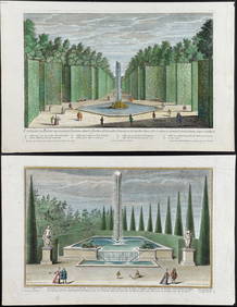
Demortain - 4 Fountain & Garden EngravingsTrillium Antique Prints & Rare Books4.5(32)See Sold PriceFeb 24, 2024
Map: An 18thC engraved and hand coloured map of North America and South America, titled DeClaydon Auctioneers Ltd4.3(125)See Sold PriceFeb 26, 2024
1738 BIBLE in DUTCH ILLUSTRATED w/ MAPS MASSIVE FOLIO in DUTCH antique BIBLIAJasper524.5(9.9k)See Sold PriceFeb 27, 2024
1730 BIBLE in DUTCH ILLUSTRATED w/ MAPS antique MASSIVE FOLIO BIBLIAJasper524.5(9.9k)See Sold PriceFeb 27, 2024
NORTH AFRICA. 'Biledulgerid', a former North African country. MALLET 1683 mapJasper524.5(9.9k)See Sold PriceFeb 28, 2024
Goode, George Brown 1884 Lot of 4 Natural History & Meteorology MapsAlbion Auctions4.7(341)See Sold PriceMar 01, 2024
Antique Pennsylvania Map Fragment incl Wellersburg and New CentervilleCordier Auctions & Appraisals4.4(1.5k)See Sold PriceMar 02, 2024
4 Presidential Prints incl Lincoln PortaritCordier Auctions & Appraisals4.4(1.5k)See Sold PriceMar 02, 2024


![[BRUÉ, ADRIEN HUBERT] A lot of 26 maps (1 of 1)](https://p1.liveauctioneers.com/1124/187577/94368850_1_x.jpg?height=282&quality=70&version=1607095126)


![[MUSIC]. A group of 4 musical publications, incl. The Lover's Forget-Me-Not, and Songs of (1 of 9)](https://p1.liveauctioneers.com/197/319238/171467978_1_x.jpg?height=282&quality=70&version=1707520367)