ATLAS of ANTIENT GEOGRAPHY by SAMUEL BUTLER 1843John McInnis Auctioneers,LLC4.5(505)See Sold PriceFeb 24, 2024
18TH C. ANTIQUE MAP: FRENCH & INDIAN WAR, FRAMEDThomaston Place Auction Galleries4.4(394)See Sold PriceFeb 24, 2024
Rand McNally Railroad Map Cabinet w/ 21 Railroad MapsRail & Road Auctions4.6(165)See Sold PriceMar 08, 2024
Keith Haring - Ink on New York Map, Best Buddies, Inscribed, Signed, and DatedSapphire Auction Gallery4.1(67)See Sold PriceMar 02, 2024
LATE 17TH C. FRENCH MAP OF THE NEW WORLD BY ALEXIS-HUBERT JAILLOT (1632-1712)Thomaston Place Auction Galleries4.4(394)See Sold PriceFeb 24, 2024
Central Railroad of New Jersey Map of Sandy Hook Route-ca. 1903JM Hobby Supply and Railroad Artifact Auctions4.4(127)See Sold PriceFeb 24, 2024
Lot of Six Mixed Atlas Box Cars-HO Scale-New in BoxJM Hobby Supply and Railroad Artifact Auctions4.4(127)See Sold PriceFeb 25, 2024
Rand McNally/Santa Fe Railroad Map of Iowa-1912JM Hobby Supply and Railroad Artifact Auctions4.4(127)See Sold PriceFeb 24, 2024
NICOLAES VISSCHER (NETHERLANDS, 1618-1709) MAP OF THE NEW WORLDThomaston Place Auction Galleries4.4(394)See Sold PriceFeb 24, 2024
17TH C. WORLD MAP BY NICOLAES VISSCHER (NETHERLANDS, 1618-1709)Thomaston Place Auction Galleries4.4(394)See Sold PriceFeb 24, 2024
Lot of Six Mixed Atlas Cabooses-HO Scale-New in BoxJM Hobby Supply and Railroad Artifact Auctions4.4(127)See Sold PriceFeb 25, 2024
SoldPennsylvania New Jersey & Delaware 1831 Map BookPennsylvania, New Jersey, and Delaware map book. Brown leather cover with gilt. 6" x 3-1/2" (separated at spine). Map 17" x 21". Published by S. Augustus Mitchell, 1831. Handcolored, splits at folds,See Sold Price
Sold(3) NEW JERSEY MAPS & (1) NEW YORK MAP, LATE 1800'SAll feature colored highlights, all originally removed from an atlas; paper is brittle; Includes: (1) "Atlas of New Jersey Counties of Camden, Salem and Gloucester"; engraved by E Busch, 320 Walnut StSee Sold Price
SoldLot of 2 Maps of Pennsylvania 1850 & 1875Lot of 2 Early Maps of Pennsylvania 1850 and 1875. 1.) 1850 A Map of The Canals and Rail Roads of Pennsylvania and New Jersey. Map Measures 28 1/4” X 21 3/4”. Is on a cardboard backing and wrappedSee Sold Price
SoldA New Map of Virginia Maryland...[Revised Description][Virginia/Maryland] A NEW MAP OF VIRGINIA MARYLAND AND THE IMPROVED PARTS OF PENNSYLVANIA AND NEW JERSEY. Engraved map, uncolored, 19 1/8 x 21 7/8 in., double-page. 2nd state: FirSee Sold Price
SoldCram's 1930 Double Sided Railway Map in Industrial Frame, New Jersey & PennsylvaniaCram's 1930 Double Sided Railway Map in Industrial Frame, New Jersey & Pennsylvania. Fantastic maps on hard board showing railways and census information are marked The George Cram Co, Indianapolis INSee Sold Price
Sold(2) DELEWARE MAPS & (1) NEW JERSEY MAP, C. 1860'SAll feature colored highlights; all originally removed from atlases; includes: (2) "Delaware City" and "Red Lion" maps, one features pencil writing, "Beer - 1868 - Red"; both indicate page "29" in topSee Sold Price
Sold1860 S. MITCHELL JR. NORTHEAST STATES COUNTY MAP1860 S. Augustus Mithcell Jr. County map of Pennsylvania, New Jersey, Maryland and Deleware. Map measures approx. 11 1/4" height x 13 3/4" width to sight..See Sold Price
SoldMitchell's County Map of Virginia and West Virginia(Philadelphia: Samuel Augustus Mitchell, Jr., 1880), the verso with maps of Maryland, Delaware, and New Jersey, presented in later, two-sided gilt frame. DOA 18 x 22 in. Additional high-resolution phSee Sold Price
Sold12 maps of northeastern states. Asher & Adams, et[United States: Mid-Atlantic]. 12 Maps. ++ 7 maps: Asher & Adams' (1) Pennsylvania And New Jersey, (2) New York And Part Of Ontario, (3) New Hampshre, Vermont, Massachusetts, Rhode Island, And ConnectSee Sold Price
Mitchell: Antique Map of Maryland Delaware New JerseyMap: County Map of Maryland and Delaware / County Map of New Jersey Cartographer: S. A. Mitchell Place & Date: Philadelphia / 1870 Size: 14" x 11 1/2" Condition: full color; light overall age toning TSee Sold Price
Antique Map of New JerseyCirca 1796 Antique Map, New Jersey, Approximate size: 8-3/8" x 6-1/4". Please note that this lot has a confidential reserve. When you leave a bid in advance of the auction, submit your maximum. JasperSee Sold Price
SoldThomas Kitchin, Maryland and Scotland maps(Scottish, 1718-1784)., "Map of Maryland with the Delaware counties and the southern part of New Jersey," hand colored map, circa 1750, 7 x 9 in. , framed and "Scotland," circa 1760, 7 1/2 x 9 in. , fSee Sold Price
Sold3 Asian maps, c. 1806[Asia]. 3 maps, double-page, outline color. Overall very good condition. ++ John Cary. A New Map Of Asia, From The Latest Authorities. Lon: 1806. 18 1/8 x 23 3/8 in. ++ Samuel Dunn. Asia, Divided IntoSee Sold Price
Mitchell: Maryland & Delaware / New JerseyMap: County Map of Maryland and Delaware / County Map of New Jersey Cartographer: S. A. Mitchell Place & Date: Philadelphia / 1870 Size: 14" x 11 1/2" Condition: full color; light overall age toning TSee Sold Price
SoldSebastian Munster, 3 woodcut maps [1552-1575].[Munster/Eastern Europe/Balkans]. 3 woodcut maps, each on double-sided leaf of French text. Each leaf 13 x 8 1/8. Titles derived from text headings or captions. (1) La Description De La Grece... IncluSee Sold Price
Mitchell: Maryland & Delaware / New JerseyTitle/Content of Map: Mitchell: Maryland & Delaware / New Jersey Date Printed: 1870, Philadelphia Cartographer: S. A. Mitchell Size: 14" x 11 1/2" Two well detailed and colored county maps, one of NewSee Sold Price
1837 Gordon Map of New Jersey -- New JerseyTitle/Content of Map: 1837 Gordon Map of New Jersey -- New Jersey Date Printed: 1,837 Cartographer: T Gordon Size: 14.3 x 11 in. A handsome map of the Garden State, with great deal of settlement and tSee Sold Price
Sold2 US maps- New Jersey & Kentucky2 State maps engraved by G. W. Boynton- ''New Jersey'' & ''Kentucky''- from ''A Universal Illustrated Atlas'', both with hand-coloring, 1842. 14 1/4 x 11 3/8'' ea.See Sold Price
SoldLarge Map of PennsylvaniaMap of Pennsylvania With map of New Jersey [and] Maryland Delaware and Baltimore County on versos Cartographer: George Franklin Cram Dated: Circa 1900See Sold Price
SoldSamuel Augustus Mitchell (1790-1868), "County Map ofSamuel Augustus Mitchell (1790-1868), "County Map of Pennsylvania, New Jersey, Maryland and Delaware," 1860, hand colored, H. -12 3/4 in., W. - 15 3/8 in.See Sold Price
SoldColton Large Antique Map of New JerseyColton's Larger Township Map of New Jersey. G.W. & C.B. Colton, New York, 1897. Separately issued, folds as issued. Sight 37" x 25 1/2", frame overall 40 3/4" x 28 1/2".See Sold Price
SoldManuscript Map of New Jersey and New Yorkcirca 1780, illustrating the trails and roads between the Delaware River and Hudson River, ink on laid paper, with crown watermark, 12-1/4 x 16 in.; unframedNote: The paths illustrated on this map folSee Sold Price
SoldBlaeu, Willem and Jan22. Blaeu, Willem and Jan.Huntingdonensis Comitatus; Huntington Shire. Double-page hand-coloured engraved map. 15-1/2 x 19-3/4 inches plus margins, in glass-fronted gilt and black wooden frame (worn aSee Sold Price
SoldLOTTER, TOBIAS CONRAD. Pennsylvania Nova Jersey et NovaLOTTER, TOBIAS CONRAD. Pennsylvania Nova Jersey et Nova York cum Regionibus ad Fluvium Delaware in America Sitis. Double-page engraved map of colonial Pennsylvania, New Jersey and New York with an elaSee Sold Price
Central Railroad of New Jersey Map of Sandy Hook Route-ca. 1903JM Hobby Supply and Railroad Artifact Auctions4.4(127)See Sold PriceFeb 24, 2024
Group of Ten Railroad Photographs, Maps, and Prints - New Jersey, Long Island, and New YorkRail & Road Auctions4.6(165)See Sold PriceMar 07, 2024
Georges Rouault (French, 1871-1958) - Perroquet (Projet Pour un Bestiaire); With Homme Debout versoFreeman's | Hindman4.5(158)See Sold PriceFeb 28, 2024
1772 GREEK BIBLE NEW TESTAMENT antique BIBLIA LATIN text MAP NOVUM TESTAMENTUMJasper524.5(9.9k)See Sold PriceFeb 27, 2024
Herman Moll A New Map of Ye North Parts of AmericaWillow Auction House4.5(292)See Sold PriceMar 14, 2024
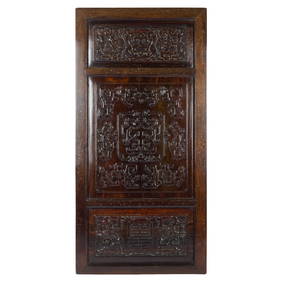
A Chinese carved zitan wood double-sided screen, 18th centuryOakridge Auction Gallery4.5(192)See Sold PriceMar 16, 2024
Antique Pennsylvania Map Fragment incl Wellersburg and New CentervilleCordier Auctions & Appraisals4.4(1.5k)See Sold PriceMar 02, 2024
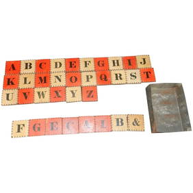
Antique Civil War Era Alphabet Block Set with Two Color Letter and Number BlocksJasper524.5(9.9k)See Sold PriceMar 07, 2024


![Sebastian Munster, 3 woodcut maps [1552-1575]. (1 of 6)](https://p1.liveauctioneers.com/179/17501/5894336_1_x.jpg?height=282&quality=70&version=1225486369)