ATLAS of ANTIENT GEOGRAPHY by SAMUEL BUTLER 1843John McInnis Auctioneers,LLC4.6(504)See Sold PriceFeb 24, 2024
18TH C. ANTIQUE MAP: FRENCH & INDIAN WAR, FRAMEDThomaston Place Auction Galleries4.4(389)See Sold PriceFeb 24, 2024
Rand McNally Railroad Map Cabinet w/ 21 Railroad MapsRail & Road Auctions4.6(165)See Sold PriceMar 08, 2024
Keith Haring - Ink on New York Map, Best Buddies, Inscribed, Signed, and DatedSapphire Auction Gallery4.1(67)See Sold PriceMar 02, 2024
LATE 17TH C. FRENCH MAP OF THE NEW WORLD BY ALEXIS-HUBERT JAILLOT (1632-1712)Thomaston Place Auction Galleries4.4(389)See Sold PriceFeb 24, 2024
Central Railroad of New Jersey Map of Sandy Hook Route-ca. 1903JM Hobby Supply and Railroad Artifact Auctions4.4(126)See Sold PriceFeb 24, 2024
Lot of Six Mixed Atlas Box Cars-HO Scale-New in BoxJM Hobby Supply and Railroad Artifact Auctions4.4(126)See Sold PriceFeb 25, 2024
Rand McNally/Santa Fe Railroad Map of Iowa-1912JM Hobby Supply and Railroad Artifact Auctions4.4(126)See Sold PriceFeb 24, 2024
NICOLAES VISSCHER (NETHERLANDS, 1618-1709) MAP OF THE NEW WORLDThomaston Place Auction Galleries4.4(389)See Sold PriceFeb 24, 2024
17TH C. WORLD MAP BY NICOLAES VISSCHER (NETHERLANDS, 1618-1709)Thomaston Place Auction Galleries4.4(389)See Sold PriceFeb 24, 2024
Lot of Six Mixed Atlas Cabooses-HO Scale-New in BoxJM Hobby Supply and Railroad Artifact Auctions4.4(126)See Sold PriceFeb 25, 2024
Sold(3) Antiquarian etched maps(3) Antiquarian etched maps, c/o "Scotia" from the book "L'Isole Piu Famose Del Mondo" by Tomaso Porcacchi (1575), "Asia" (hand-colored, 17th century), and "Ipswich" (18th century), largest 11-3/4" xSee Sold Price
(3) Antiquarian Map engravings(3) antiquarian Map engravings. Isle de Wight, The Smaller Islands of the British Ocean & Yorkshire. Framed. (Approx. 14.5" x 17" to 8" x 10.5").See Sold Price
Sold(3) Antiquarian Map engravings(3) antiquarian Map engravings. Isle de Wight, The Smaller Islands of the British Ocean & Yorkshire. Framed. (Approx. 14.5" x 17" to 8" x 10.5").See Sold Price
Sold(3) Antiquarian Map engravings(3) antiquarian Map engravings. The Invasions of England & Ireland, New Map of Bedfordshire & Sussex. (Approx. 22" x 17", 21" x 18.5" & 23" x 16.5").See Sold Price
SoldEgypt.- Burckhardt (John Lewis) Travels in NubiaEgypt.- Burckhardt (John Lewis) Travels in Nubia,second edition, etched portrait, 3 engraved maps, 2 folding, maps lightly foxed, bookplate of Charles Winn, Nostell Priory on front pastedown,See Sold Price
SoldIrwin (Eyles) Red SeaIrwin (Eyles) A Series of Adventures in the course of a Voyage up the Red Sea,first edition, half-title, engraved plan and 3 folding maps, 4 etched and sepia aquatint views on 2 plates, offsetSee Sold Price
Egypt.- Burckhardt (John Lewis) Travels in NubiaEgypt.- Burckhardt (John Lewis) Travels in Nubia,first edition, etched portrait frontispiece, 3 maps, including 2 folding, one with a small tape repair to verso, occasional foxing and browningSee Sold Price
Sold(3) Antiquarian Books,Washington, 1864 & New World,1857Collection of 1st edition antiquarian books. 19th century historic book on George Washington & 2 volumes on American New World history. Maps, colored lithographs, wood and steel engravings throughoutSee Sold Price
Sold(3) Antiquarian Books.(3) Antiquarian Books. The Descriphon of Greece by Pausanias. London for R. Faudler, 1794, full leather binding. (Volume 1: Front cover loose, complete with illustration and maps).See Sold Price
Sold*ANTIQUARIAN MAP"A Map: The Dark Shadow Over England and the 5 Great Solar Eclipses", by unknown artist printed for Robert Sayer of London in 1787, approximate plate size 12 3/8" x 12 3/8", frame 25" x 25".See Sold Price
Rennie (David Field) - Bhotan and the Story of theetched frontispiece, 3 plates and folding map, a little soiled and some occasional light spotting, bookplate to front pastedown, modern half calf, 8vo, 1866.See Sold Price
Sold[Dogs] Dandie Dinmont TerrierCook, Charles. THE DANDIE DINMONT TERRIER, ITS HISTORY AND CHARACTERISTICS. Edinburgh: David Douglas, 1885. 4to (10.25" x 7.25".) xiii, [3], 148 pp., 7 etched plates, 1 double-page map, and title vignSee Sold Price
SoldDECOUPAGE WASTE BASKETVintage Decoupage Decorated Waste Basket, with antiquarian map design to exterior, interior with wood grain textured finish, 14 3/4" high, 12 1/4" x 7 1/2". Small top edge crease.See Sold Price
-. Rennie (David Field) Bhotan and the Story of th-. Rennie (David Field) Bhotan and the Story of the Dooar War,etched frontispiece, 3 plates and folding map, a little soiled and some occasional light spotting, bookplate to front pastedown, mSee Sold Price
Rennie (David Field) - Bhotan and the Story of theetched frontispiece, 3 plates and folding map, a little soiled and some occasional light spotting, bookplate to front pastedown, modern half calf, 8vo, 1866.See Sold Price
SoldCHINESE SILVER COMPACT GEOA Chinese silver compact having hand etched map of China near the East China Sea. Cover has chased calligraphy symbol. Measures 4" diameter x 3/8" depth (10.1cm x 0.9cm). Total weight of 6.5ozt.See Sold Price
SoldFOLDING TRAY TABLE SET WITH STANDSet of Four Contemporary Wooden Tray Tables with Stand, tables with melamine tops, each decorated with a different antiquarian map design, stand with top handle, 30 1/2" high, 19 3/4" x 9 1/2", each tSee Sold Price
Etched Crystal 3" GlobeEtched Crystal 3" Globe This etched crystal globe features a 3D map of the world with meridian lines, on a quality crystal sphere with no known damage. This is a perfect decor item for your office desSee Sold Price
Etched Crystal 3" GlobeEtched Crystal 3" Globe This etched crystal globe features a 3D map of the world with meridian lines, on a quality crystal sphere with no known damage. This is a perfect decor item for your office desSee Sold Price
Rennie (David Field) Bhotan and the Story of the DRennie (David Field) Bhotan and the Story of the Dooar War,etched frontispiece, 3 plates and folding map, a little soiled and some occasional light spotting, bookplate to front pastedown, modeSee Sold Price
Sold***UNFRAMED ANTIQUARIAN ENGRAVED MAP***UNFRAMED ANTIQUARIAN ENGRAVED MAP| With later hand coloring, depicting English counties, engraved by Johann Blaeu, approximate size of engraved area 15 3/4" x 19 3/4", total sheet size 20 1/2" x 23See Sold Price
Sold*ANTIQUARIAN ENGRAVED MAPCartographer Johann Baptist Homann from ca. 1729, 2-piece map with handcoloring, approximate total work size 24" x 19 3/4", frame 25" x 21 1/2". Provenance: From the Estate of Franz Altschuler.See Sold Price
Sold***UNFRAMED ANTIQUARIAN ENGRAVED MAP| Depicting***UNFRAMED ANTIQUARIAN ENGRAVED MAP| Depicting Britain and it's Isles, engraved by Petrus (Peter Calavert), approximate size of engraved area 15 3/8" x 20 1/4", total sheet size 17 1/2" x 20 3/4".See Sold Price
Sold***UNFRAMED ANTIQUARIAN ENGRAVED MAP***UNFRAMED ANTIQUARIAN ENGRAVED MAP| With later hand coloring, "Britain Antique", produced by Robert Sayer & Bennett, published circa 1775, approximate size of engraved area 21 3/4" x 20 1/2", totalSee Sold Price
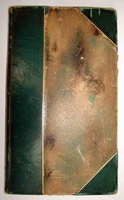
ROBERT BROWNING Rare 1902 LE "Pippa Passes" Calf Binding 1st EdLuis Porretta Fine Arts4.3(10)See Sold PriceMar 02, 2024
DAVID ROBERTS - Holy Land / Syria / Egypt etc. 3 x Folio Volumes 1849 Very RareLuis Porretta Fine Arts4.3(10)See Sold PriceMar 02, 2024
OFFER VAN ABRAHAM Book Of Genesis in Engravings c1700 Amsterdam Very rare!Luis Porretta Fine Arts4.3(10)See Sold PriceMar 02, 2024
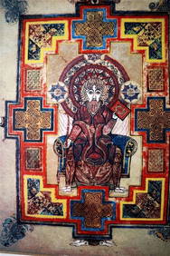
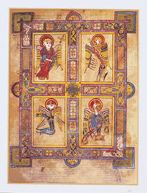
THE BOOK OF KELLS 3 x Limited Edition Serigraph Hand Made Prints Celtic ArtLuis Porretta Fine Arts4.3(10)See Sold PriceMar 02, 2024
THE BOOK OF KELLS 3 x Limited Edition 30 Color Serigraph Prints Celtic ArtLuis Porretta Fine Arts4.3(10)See Sold PriceMar 02, 2024
FRANK MARMINGTON c1910 National Gallery Canada Signed Engraving London St. Pauls 20" x 16"Luis Porretta Fine Arts4.3(10)See Sold PriceMar 02, 2024
VENET / DEBUCOURT (1755-1832) Set 3 x Aquatint Engraved Hunting Scenes 23" x 16"Luis Porretta Fine Arts4.3(10)See Sold PriceMar 02, 2024
HENRY ALKEN The Quorn Hunt Original Aquatint ca1840 Equestrian FramedLuis Porretta Fine Arts4.3(10)See Sold PriceMar 02, 2024
FRANCIS CALCRAFT TURNER Bachelors Hall Plate 3 ca1835 Original Colored LithoLuis Porretta Fine Arts4.3(10)See Sold PriceMar 02, 2024
DUNLEVIE c1856 Map Counties Of Gaspe & Bonaventure Quebec Canada SCARCE! #1Luis Porretta Fine Arts4.3(10)See Sold PriceMar 02, 2024
O. K. SHENK Limited Edition Print "Song Of Surf" Canadian Listed Artist (54/375)Luis Porretta Fine Arts4.3(10)See Sold PriceMar 02, 2024
Joseph Martin Kronheim Pair Early Color Glamor Prints c1850Luis Porretta Fine Arts4.3(10)See Sold PriceMar 02, 2024
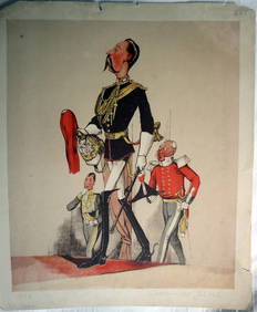
JOSEPH MARTIN KRONHEIM - "Captain Of The Blues" Early Colore Printing MilitaryLuis Porretta Fine Arts4.3(10)See Sold PriceMar 02, 2024
1938 American Armies and Battlefields by the American Battle Monuments CommissionNorth American Artifact Auctions4.6(184)See Sold PriceApr 20, 2024
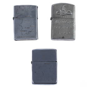
WWII Korea & Vietnam Era Silver Lighters 3pc LOTHill Auction Gallery 4.7(1k)See Sold PriceFeb 28, 2024
Willem Blaeu, Etc. 17th C. Antiquarian Maps, 2Auctions at Showplace4.6(731)See Sold PriceMar 17, 2024
Chatelain - 3 Maps of the British Isles (England, Ireland, Scotland)Trillium Antique Prints & Rare Books4.5(30)See Sold PriceFeb 24, 2024
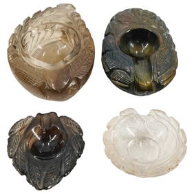
(4 Pc) Collection Of Miniature Individual Etched Glass AshtraysAkiba Galleries4.7(1.8k)See Sold PriceFeb 29, 2024
Set of 3 Maps - Netherlands - Belgien - Switzerland - J. BarlowProverde Auctions4.3(3)See Sold PriceFeb 28, 2024
Set of 3 Etched Glass ItemsRapid Estate Liquidators and Auction Gallery4.5(1.1k)See Sold PriceFeb 27, 2024


![[Dogs] Dandie Dinmont Terrier (1 of 6)](https://p1.liveauctioneers.com/3532/163584/82609376_1_x.jpg?height=282&quality=70&version=1583732116)