Sold20th C. U.S. Geological Survey MapsGrouping of 74 early 20th C. U.S. Geological Survey maps of Pennsylvania, New Jersey, New York, Connecticut, Rhode Island, Massachusetts.See Sold Price
265 Topographical Maps, assorted contour maps, U.265 Topographical Maps, assorted contour maps, U.S. Geological Survey, early 20th century, 16 1/2 x 20 in. each.See Sold Price
SoldNantucket Map, c. 1890Two U.S. geological survey topographical chart maps framed and matted together, showing Nantucket Tuckernuck and Muskeget,c.1890, Overall, 35” x 45”See Sold Price
Map of Public Surveys in California to Accompany ReportReserve Reduced! Title: Map of Public Surveys in California to Accompany Report of Surveyor General Publication Date: 1856 Cartographer: John C. Hays Publisher: U.S. Geological Survey Size (inches): HSee Sold Price
Land Classification Map Part of Southern Colorado 1878Map: Land Classification Map of Part of Southern Colorado Maker: U.S. Geological Survey, George Wheeler Publishing: Washington DC 1878 Size: 15 x 19.3 inches "Atlas sheet No. 62 (C) U.S. Geological suSee Sold Price
SoldLarge colored map of Shasta Co. CA 1912Heading: (California - Shasta County) Author: Wiegel, C. R. Title: Map of the County of Shasta California. Compiled from U.S. geological and U.S. land surveys, official and private surveys, etc. by C.See Sold Price
SoldUS Geological Survey Map of the United StatesVery large book of US maps, from the whole country. All color topographical maps, featuring quadrant sections. This book measures 28"x19", and has railroads indicated on the maps. These maps are detaiSee Sold Price
1958 US Geological Survey Map of Yosemite Valley -- MapTitle/Content of Map: 1958 US Geological Survey Map of Yosemite Valley -- Map of Yosemite Valley, Yosemite National Park, California, Mariposa County Date: 1558, Washington DC Cartographer: US GeologiSee Sold Price
SoldCATALOG OF US GEOLOGICAL SURVEY MAPS OF MAINE"Railroad Station" Binding of (187) Maps of Maine published between roughly 1928-1956, indexed by town at front, in black hinged hardcover with tabulation. 22 1/2" x 19". Generally good condition, somSee Sold Price
CATALOG OF US GEOLOGICAL SURVEY MAPS OF MAINE"Railroad Station" Binding of (187) Maps of Maine published between roughly 1928-1956, indexed by town at front, in black hinged hardcover with tabulation. 22 1/2" x 19". Generally good condition, somSee Sold Price
1958 US Geological Survey Map of Yosemite Valley -- MapTitle/Content of Map: 1958 US Geological Survey Map of Yosemite Valley -- Map of Yosemite Valley, Yosemite National Park, California, Mariposa County Date: 1558, Washington DC Cartographer: US GeologiSee Sold Price
Sold1938 U.S. Geological Survey Map of Oahu Hawaii"Geologic and Topographic Map of the Island of Hawaii. Showing well, springs, tunnels, shafts, proposed Kalihi-Waiahole tunnel, specimen localities and structure sections". Inset map of Honolulu, explSee Sold Price
Sold1958 US Geological Survey Map of Yosemite Valley -- MapTitle: 1958 US Geological Survey Map of Yosemite Valley -- Map of Yosemite Valley, Yosemite National Park, California, Mariposa County Cartographer: US Geological Survey Year/Place: 1558, Washington DSee Sold Price
Sold1938 U.S. Geological Survey Map of Oahu Hawaii"Geologic and Topographic Map of the Island of Hawaii. Showing well, springs, tunnels, shafts, proposed Kalihi-Waiahole tunnel, specimen localities and structure sections". Inset map of Honolulu, explSee Sold Price
SoldHUNDREDS Nautical, Geology & World Geography MapsAn historical estate collection consisting of hundreds of individual maps and charts, produced by and for various sources. Includes original U.S. Geological Survey maps, National Geographic Society woSee Sold Price
SoldGROUPING OF FRAMED MAPSIncluding mostly maps of Connecticut, also including a pair of US geological survey maps. Also including vintage J. H. Colton & Co. map of Connecticut. Also included is a reproduction of 1785 map of tSee Sold Price
SoldANTIQUE LINED MA NY VT TACONIC QUADRANGLE MAPdepartment of interior US geological survey map. has been lined and cut . current measurement 17 3/4" by 13". map shows some highlighted travel routeSee Sold Price
Map Of The United StatesU.S. Geological Survey/Map, Mcgee, W. J., 1884, Folio – 17.25 H X 28.25 W Inches, "exhibiting The Present Status Of Knowledge Relating To The Areal Distribution Of Geologic Groups (preliminary CompiSee Sold Price
30 Geological Survey Mars Maps30 U.S. Geological Survey Maps of Mars prepared for NASA in 1981. This spectacular collection contains both maps and photo mosaics of the southeast part of the red planet. Each map is approximately 30See Sold Price
SoldState of Connecticut Framed Map1893 U.S. Geological survey Map reprinted in 1927. laid down under glass. good condition overall. Total measurement: 47" x 58"See Sold Price
SoldUS GEOLOGICAL MAP ST. HELENA SOUND-SAVANNAH RIVERLARGE FRAMED US GEOLOGICAL SURVEY MAP ST. HELENA SOUND-SAVANNAH RIVERSee Sold Price
SoldUS GEOLOGICAL MAP CHARLESTON HARBOR APPROACHESLARGE US GEOLOGICAL SURVEY MAP CHARLESTON HARBOR APPROACHESSee Sold Price
SoldSet of 3 U.S. Geological Survey Copper Map PlatesRare Vintage Set of Three United States Geological Survey (USGS) Copper Map Plates, each of the three engraved plates illustrating a topographical map of Holston Valley, the tri-city region of KingspoSee Sold Price
SoldSet of 3 U.S. Geological Survey Copper Map PlatesRare Antique Set of Three United States Geological Survey (USGS) Copper Map Plates, each of the three engraved plates illustrating a topographical map of Continental, Ohio, 4100 N latitude and 8415 WSee Sold Price
DODIE THAYER (US, 20TH C.) MAJOLICA TUREENThomaston Place Auction Galleries4.4(393)See Sold PriceFeb 25, 2024
Carole Scott (US 20th C) Hand Painted Porcelain Plaque of Birds, SignedTaylor & Harris4.7(161)See Sold PriceMar 10, 2024
Three American Military Style Knives, 20th c., M3- L.- Blade- 6 5/8 in., Overall- 11 1/2 in.;Crescent City Auction Gallery4.3(231)See Sold PriceMar 01, 2024
Pair Quince Quaintance (American 20th c ) Signed Beach Themed ArtAbsolute Auction Gallery4.5(58)See Sold PriceFeb 28, 2024
Nottingham.- Ordnance Survey Office (publisher) Collection 8 geological maps on the environs ofForum Auctions4.3(53)See Sold PriceFeb 29, 2024
INDIA WITHIN THE GANGES SUSAN GOLE ILLUSTRATED MAPS EARLY CARTOGRAPHYJasper524.5(9.9k)See Sold PriceFeb 27, 2024
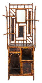
Aesthetic Movement Faux Bamboo Etagere, 20th CAuctions at Showplace4.6(740)See Sold PriceApr 07, 2024
Virginia and West Virginia Topography MapsRapid Estate Liquidators and Auction Gallery4.5(1.1k)See Sold PriceFeb 28, 2024