SoldEastern Russia (1758) & western Russia (1750).[Russia]. [Russia]. 2 double-page engraved maps, hand-colored outline, by Robert De Vaugondy. ++ Partie Occidentale De L'Empire Russie, Ou se trouve distinguee la Russie Europeenne. La Partie AsiatiquSee Sold Price
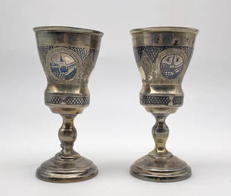
Sold2 maps of Russia: Vaugondy, 1750 + [1757-1758].[Russia & Asia]. 2 engraved double-page maps, outline hand-coloring, very good condition overall, both by Robert de Vaugondy. ++ Partie Occidentale De L'Empire De Russie. Paris: 1750. 18 x 23 1/4 in.See Sold Price
Russian Coins from Various PropertiesRussia, Elizabeth (1741-62), Five Kopecks (2), 1758, 1762, no mintmark (Brekke 122, 130), 2 Kopecks (2), 1757, 1758 (Brekke 91, 98), Kopeck, 1755, St Petersburg (Brekke 48), Dengæ (3), 1748, 1750,See Sold Price
Sold2 Kopeks lot, 1757 & 1758, Ekaterinburg, Copper.Country: RUSSIA 2 Kopeks lot, 1757 & 1758, Ekaterinburg, Copper. FVF, please inspect!See Sold Price
Parte Orientale l'Empire Russie en Asie Siberia Russia Asia. VAUGONDY 1750 mapTITLE OF MAP (NOT PRINTED ON THE PAGE):'Partie Orientale de l'Empire de Russie en Asie, où se trouvent les Provinces de Jakuckskoy, Nerckzinskoy, Selinginskoy, Ilimskoy, Krasnojarskoy, Narimskoy,See Sold Price
SoldDe Vaugondy, 2 maps of Italy, 1750[Italy]. Robert de Vaugondy. 2 double-page engraved maps. ++ Partie Septentrionale Du Royaume De Naples. ++ Partie Meridinale Du Royaume De Naples: Ou se trouvent la Calabre et L'Isle et Royaume de SiSee Sold Price
Bellin: Arctic Coasts of European Russia (2 maps)Title/Content of Map: Bellin: Arctic Coasts of European Russia (2 maps) Date Printed: 1757/1760, Paris Cartographer: Bellin Size: (1) 9 1/2" x 7 3/8"; (2) 12" x 8" Two maps by Bellin of the Arctic coaSee Sold Price
Bellin: Arctic Coasts of European Russia (2 maps)Title/Content of Map: Bellin: Arctic Coasts of European Russia (2 maps) Date Printed: 1757/1760, Paris Cartographer: Jacques Nicolas Bellin Size: (1) 9 1/2" x 7 3/8"; (2) 12" x 8" Two maps by Bellin oSee Sold Price
Bellin: Arctic Coasts of European Russia (2 maps)Title/Content of Map: Bellin: Arctic Coasts of European Russia (2 maps) Date Printed: 1757/1760, Paris Cartographer: Bellin Size: 9 1/2" x 7 3/8" (1); 12" x 8" (2) Two maps by Bellin of the Arctic coaSee Sold Price
Bellin: Arctic Coasts of European Russia (2 maps)Title/Content of Map: Bellin: Arctic Coasts of European Russia (2 maps) Date Printed: 1757/1760, Paris Cartographer: Bellin Size: 9 1/2" x 7 3/8" (1); 12" x 8" (2) Two maps by Bellin of the Arctic coaSee Sold Price
Bellin: Arctic Coasts of European Russia (2 maps)Title/Content of Map: Bellin: Arctic Coasts of European Russia (2 maps) Date Printed: 1757/1760, Paris Cartographer: Bellin Size: (1) 9 1/2" x 7 3/8"; (2) 12" x 8" Two maps by Bellin of the Arctic coaSee Sold Price
2 Maps incl: LA JUDEE OU TERRE SAINTE. 1750.[Middle East/Israel] 2 Maps. ++ LA JUDEE OU TERRE SAINTE, divisee en ses douze Tribus. Robert [de Vaugondy], 1750. Large inset: Carte de la Terre de Canaan. Orig hand-colored outline, scale uncolored.See Sold Price
Parte Orientale l'Empire Russie en Asie Russia Siberia Asia. VAUGONDY 1750 mapTITLE OF MAP (NOT PRINTED ON THE PAGE):'Partie Orientale de l'Empire de Russie en Asie, où se trouvent les Provinces de Jakuckskoy, Nerckzinskoy, Selinginskoy, Ilimskoy, Krasnojarskoy, Narimskoy,See Sold Price
Parte Occidentale l'Empire Russie… Russia Siberia Asia. VAUGONDY 1750 mapTITLE OF MAP (NOT PRINTED ON THE PAGE):'Partie Occidentale de L'Empire de Russie, où se trouve distinguée la Russie Europeenne, divisée par ses Gouvernemens ou Provinces de Dwinskoy, OlSee Sold Price
LARGE 18TH C MAP OF RUSSIAA FINE 18TH CENTURY MAP OF RUSSIA, 1750, ROBERT DE VAUGONDY. Partie Occidentale DE L'EMPIRE DE RUSSIE A finely engraved map with large title cartouche upper left dated 1750, original hand-colorinSee Sold Price
Bellin: Arctic Coasts of European Russia (2 maps)Title/Content of Map: Bellin: Arctic Coasts of European Russia (2 maps) Date Printed: Paris/1757/1760 Cartographer: Bellin Size: 9 1/2" x 7 3/8" (1); 12" x 8" (2) Two maps by Bellin of the Arctic coasSee Sold Price
Sold4 Dbl-page Maps: 2 Israel + ARRAGONIA REGNUM + 1 other.[Israel/Mideast/France] 4 Maps. Double-page. ++ LA JUDEE OU TERRE SAINTE. Robert [de Vaugondy], 1750. Large inset: Carte de la Terre de Canaan. Orig hand-colored outline, scale uncolored. 19” x 23��See Sold Price
Bellin: Arctic Coasts of European Russia (2 maps)Map Title: 1. Carte des Pais Habites par les Samojedes et Ostiacs 2. Carte du Detroit de Waeigats ou de Nassau Cartographer: Bellin Place / Date: Paris / 1757/1760 Size: 9 1/2" x 7 3/8" (1); 12" x 8"See Sold Price
Bellin: Arctic Coasts of European Russia (2 maps)Map Title: 1. Carte des Pais Habites par les Samojedes et Ostiacs 2. Carte du Detroit de Waeigats ou de Nassau Cartographer: Bellin Place/Date: Paris / 1757/1760 Size: 9 1/2" x 7 3/8" (1); 12" x 8" (2See Sold Price
Bellin: Antique Maps of European & Asian Russia, 1757Map: 1. Carte de la Siberie et des Pays Voisins 2. Suite de la Carte de la Siberie et le Pays de Kamtschatka Cartographer: Bellin Place & Date: Paris / 1757/1760 Size: 17 3/4" x 11 1/2 (1); 10 1/8" xSee Sold Price
Bellin: Antique Maps of Russia in Europe & Asia, 1757Map: 1. Carte de la Siberie et des Pays Voisins 2. Suite de la Carte de la Siberie et le Pays de Kamtschatka Cartographer: Bellin Place & Date: Paris / 1757/1760 Size: 17 3/4" x 11 1/2 (1); 10 1/8" xSee Sold Price
SoldMap of Spain, Robert de VaugondyHispania Antiqua map of Spain. Robert de Vaugondy, 1750. [Sight: 19 1/4" x 22 1/2"; Frame: 25 1/2" H x 29" W]. Frame missing glass. Creases and water damage.See Sold Price
SoldMap of Spain, Robert de VaugondyHispania Antiqua map of Spain. Robert de Vaugondy, 1750. [Sight: 19 1/4" x 22 1/2"; Frame: 25 1/2" H x 29" W]. Frame missing glass. Creases and water damage.See Sold Price
Vaugondy: Antique Map of European Russia, 1757Map: Partie Meridionale De La Russie Europeenne Publication Date: 1757 Authors: LES AUTEURS ET BOUDET, ROBERT DE VAUGONDY, DIDIER (1723-1786) Publisher: LES AUTEURS ET BOUDET Size: Elephant Folio �See Sold Price
Grand Trunk Railroad Across the Continent Through Canada Book-1917JM Hobby Supply and Railroad Artifact Auctions4.4(126)See Sold PriceFeb 24, 2024
Johann Homann Hand-Colored Map Engraving, c. 1730Auctions at Showplace4.5(726)See Sold PriceMar 17, 2024
Willem Blaeu, Etc. 17th C. Antiquarian Maps, 2Auctions at Showplace4.5(726)See Sold PriceMar 17, 2024
1816 MAP SOUTHERN PART OF RUSSIA or MUSCOVY in EUROPE copper engraving ANTIQUEJasper524.5(9.8k)See Sold PriceFeb 27, 2024
1816 MAP NORTHERN PART OF RUSSIA or MUSCOVY in EUROPE copper engraving ANTIQUEJasper524.5(9.8k)See Sold PriceFeb 27, 2024
1758 MAP PARTIE DE LA MER GLACIALE contenants La Nouvelle Zemble RUSSIA antiqueJasper524.5(9.8k)See Sold PriceFeb 27, 2024
1750 Bowen Map of Bermuda and St. Kitts -- A New & Accurate Map of Bermudas or Sommer's Islands...Jasper524.5(9.8k)See Sold PriceFeb 27, 2024
Buffon, Vaugody & Bell 1785 America - Map of the New ContinentAlbion Auctions4.6(336)See Sold PriceMar 01, 2024
THE ANTIQUE ILLUSTRATED BOOK "1856 ARCTIC EXPLORATIONS: SECOND GIRNEL EXPEDITION 2" BY E. KANENY Elizabeth 4.3(84)See Sold PriceMar 03, 2024
Robert de Vaugondy - Map of Canada - Mer de l' Ouest or Sea of the West and a Northwest PassageProverde Auctions4.3(3)See Sold PriceFeb 28, 2024
![2 maps of Russia: Vaugondy, 1750 + [1757-1758]. First Image](https://p1.liveauctioneers.com/179/15522/5074180_1_x.jpg?height=282&quality=95&version=1206672512&width=282)

![2 maps of Russia: Vaugondy, 1750 + [1757-1758]. First Image](https://p1.liveauctioneers.com/179/15522/5074180_1_x.jpg?height=282&quality=1&version=1206672512&width=282)
![2 maps of Russia: Vaugondy, 1750 + [1757-1758]. (1 of 2)](https://p1.liveauctioneers.com/179/15522/5074180_1_x.jpg?height=282&quality=70&version=1206672512)