ATLAS of ANTIENT GEOGRAPHY by SAMUEL BUTLER 1843John McInnis Auctioneers,LLC4.5(505)See Sold PriceFeb 24, 2024
18TH C. ANTIQUE MAP: FRENCH & INDIAN WAR, FRAMEDThomaston Place Auction Galleries4.4(393)See Sold PriceFeb 24, 2024
Rand McNally Railroad Map Cabinet w/ 21 Railroad MapsRail & Road Auctions4.6(165)See Sold PriceMar 08, 2024
Keith Haring - Ink on New York Map, Best Buddies, Inscribed, Signed, and DatedSapphire Auction Gallery4(67)See Sold PriceMar 02, 2024
LATE 17TH C. FRENCH MAP OF THE NEW WORLD BY ALEXIS-HUBERT JAILLOT (1632-1712)Thomaston Place Auction Galleries4.4(393)See Sold PriceFeb 24, 2024
Central Railroad of New Jersey Map of Sandy Hook Route-ca. 1903JM Hobby Supply and Railroad Artifact Auctions4.4(127)See Sold PriceFeb 24, 2024
Lot of Six Mixed Atlas Box Cars-HO Scale-New in BoxJM Hobby Supply and Railroad Artifact Auctions4.4(127)See Sold PriceFeb 25, 2024
Rand McNally/Santa Fe Railroad Map of Iowa-1912JM Hobby Supply and Railroad Artifact Auctions4.4(127)See Sold PriceFeb 24, 2024
NICOLAES VISSCHER (NETHERLANDS, 1618-1709) MAP OF THE NEW WORLDThomaston Place Auction Galleries4.4(393)See Sold PriceFeb 24, 2024
17TH C. WORLD MAP BY NICOLAES VISSCHER (NETHERLANDS, 1618-1709)Thomaston Place Auction Galleries4.4(393)See Sold PriceFeb 24, 2024
Lot of Six Mixed Atlas Cabooses-HO Scale-New in BoxJM Hobby Supply and Railroad Artifact Auctions4.4(127)See Sold PriceFeb 25, 2024
Sold(2) 19th Century Colored Maps of NH & VT19TH CENTURY ATLAS BOOK PLATE OF NH AND VT- AUGUSTUS MITCHELL JR. 1862- 15 1/2" X 12 1/2"- TONING, FOXING AND IMPERFECTIONSSee Sold Price
Sold19th Century Colored Map of NH & VT19TH CENTURY ATLAS BOOK PLATE MAP OF NEW HAMPSHIRE AND VERMONT- JOHNSON'S NH AND VT BY JOHNSON AND WARD- 26 1/2" X 17 3/4"- TONING, FOXING, CREASES, SMALL LOSSES TO EDGES AND IMPERFECTIONSSee Sold Price
Sold19th Century Colored Map of Maine, NH & VT19TH CENTURY ATLAS BOOK PLATE OF NH AND VT FRONT MAINE ON REVERSE- GRAYS ATLAS 17 1/4" X 14 1/2"- TONING, SPOTTING, STAIN ON EDGE, AND IMPERFECTIONSSee Sold Price
SoldLOT OF (2) FRAMED COLORED MAPS, 19TH CENTURYOne is Mexico Overall framed- 21" x 26", 22 3/4" x 27"See Sold Price
Sold(2) Late 19th c. maps of Ireland, unframedTwo late 19th century colored maps of Ireland, comprising a map of Ireland printed for The Century Atlas, circa 1897, 16"h x 11"w, unframed, and a map of Ireland printed for The Society for the DiffusSee Sold Price
SoldLOT OF EARLY 19TH CENTURY HAND COLORED MAPSEleven hand colored maps published by J. Mawman, May 1819. Includes Africa, Germany, England, India, etc. 10 1/4" x 8 1/2"See Sold Price
SoldGroup of six 19th century hand colored engraved maps toGroup of six 19th century hand colored engraved maps to include New Jersey, Wisconsin, Florida, Eastern United States, Maryland and Michigan. sight size: 14" x 11 1/2" to 11 1/2" x 14".See Sold Price
SoldTopographical Map of Monadnock Mountain19TH CENTURY COLORED BOOK PLATE MAP- MONADNOCK MOUNTAIN PUBLISHED BY APPALACHIAN MOUNTAIN CLUB 1891- 11" X 8 1/2"- CREASES, SMALL TEARS AND IMPERFECTIONSSee Sold Price
SoldPhelps' Map of the United States, 1834Phelps’ Map of the United States from the Best Authorities. H. Phelps (fl. mid-19th century). Hand-colored Lithographed map. New York: H. Phelps, 1834. 30 x 39 1/2 inches sheet, 34 3/4 x 44 1/2 inchSee Sold Price
SoldHand colored maps, 19th century, Planisphere, Worl(lot of 2) Framed hand colored maps, ''Planisphere,'' pl. 93 from ''Atlas Illustre,'' c. 1854, and ''The World,'' 1851, engraved by S. Hall, published by A and C Black, Edinburgh, largest overall: 22'See Sold Price
Sold2 19th Century MapsDESCRIPTION: Two 19th century maps. Includes: 1) Asher & Adams map of Florida with colored counties. Tears, abrasions, toning, spotting, split and hinged on reverse. Sealed under plastic against a foaSee Sold Price
SoldTwo 19/20th C. Colored Hondius Astrological MapsTwo late 19th/early 20th Century hand-colored astrological maps (Henricus Hondius), 16 1/2" x 19" and 23 1/2" x 25 1/2", note watermark.See Sold Price
SoldTwo Scandinavian mapsTwo 19th century Scandinavian Maps, hand colored lithographs. Entitled "Denmark" and "Sweden and Norway" by J. Harrison, Philadelphia. Some toning. Images 9 1/2 x 11 1/4", framed 11 1/2 x 14 1/2" overSee Sold Price
SoldSeven W. & A. K. Johnston 19th Century MapsAll hand colored, mid-19th century maps including: 1. Turkey in Europe; 25 3/4"W, 21 1/4"H; 2. Turkey in Asia (shows Cyprus); 25 3/4"W, 21 1/4"H; 3. Van Diemen's Land or Tasmania; 21 1/4"W, 25 3/4"H;See Sold Price
SoldSet of four hand colored engraved maps, state of Ohio,Set of four hand colored engraved maps, state of Ohio, Virginia, Maryland and Delaware, early 19th century. sight size: 16 1/2" x 9 1/2" to 15" x 19 1/4".See Sold Price
SoldEARLY HAND COLORED MAP OF FLORENZ/FIERENZE. LATE18TH/EALY 19TH CENTURY. IN ARCHIVAL FRAME AND GLAZED WITH UV GLASS. SIGHT SIZE 19 1/2" X 22 1/2" OVERALL WITH FRAME 24" X 27" EXCELLENT CONDITION.See Sold Price
Hand Colored Map of Hampshire by Robert MordenExposed area measures approx. 14"h x 16 1/2"w. It is printed on laid paper and has hand colored borders. Item may date to late 18th/early 19th century.See Sold Price
SoldTwo Framed Hand-colored Engraved Maps, 19th/20thTwo Framed Hand-colored Engraved Maps, 19th/20th Century, Including a map of Morea olim Peloponnesus by Gerardus Mercator and of Deventer by Johannes Blaeu. Largest framed dimensions: h: 21 1/2 x w: 2See Sold Price
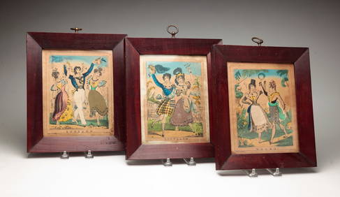
Sold(3) Antiquarian Books,Washington, 1864 & New World,1857Collection of 1st edition antiquarian books. 19th century historic book on George Washington & 2 volumes on American New World history. Maps, colored lithographs, wood and steel engravings throughoutSee Sold Price
Sold19th century Maps of Asia and Europe(lot of 2) Hand-colored copper engraved maps, "Carte de l'Asie," 1829 and "Carte des etats de l'Europe," 1829, for Herisson Geographe, published in Paris chez Jean, rue St. Jean de Beauvais No. 10, ovSee Sold Price
Sold19th Century Map of North AmericaVictor Levasseur (French, 1800-1870) Amérique Septentrionale Steel-engraved map, hand-colored in outline, with large hand-colored pictorial vignette border by Raimond Bonheaur. 12 1/2" Tall 18" widSee Sold Price
SoldTwo 19th Century Southern Atlas Mapsincluding Amer. Sep. Partie des Etats Unis by Vandermaelen, 1825, from Vandermaelen's Atlas Universal, hand-colored in outline, a map of the Carolinas and Georgia, 21 x 27-1/2 in.,ÂSee Sold Price
7 Engraved and Hand-Colored MapsLot of seven maps, engraved and hand-colored, by S. Augustus Mitchell, Pierre Jean Bonpare, William and Joan Blaeu, etc., two unframed, circa 17th, 18th and 19th centuries, 14 3/4"h x 19 1/2"w (view),See Sold Price
SoldFive Unframed 18th and 19th Century Mapsincluding Kentucky by Joseph T. Scott, 1795, 6-1/2 x 8-1/4 in.; County Map of Virginia and North Carolina by S. Augustus Mitchell, 1860, hand-colored, 12-1/2 x 15-1/4 in.; Battle-Field inSee Sold Price
19th Century Pennsylvanian Chalk Ware DogStefek's Auctioneers & Appraisers4.6(113)See Sold PriceFeb 28, 2024
Mitchell - Map of the City of Washington (Washington, DC)Trillium Antique Prints & Rare Books4.5(32)See Sold PriceFeb 24, 2024
HAND COLORED EMBOSSED PAPER PICTURE.Amelia Jeffers, Auctioneers & Appraisers4.5(120)See Sold PriceMar 08, 2024
THREE HAND COLORED AND ADORNED PRINTS.Amelia Jeffers, Auctioneers & Appraisers4.5(120)See Sold PriceMar 08, 2024
2 PIECES 19C ENGLISH COLORED ENGRAVINGS SIGNED WITH ORIGINAL HANCARVED FRAMESBidhaus4.3(762)See Sold PriceFeb 28, 2024
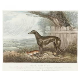
after Sydney R. Wombill (English, Late 19th/Early 20th century), Miss GlendyneLeland Little4.5(701)See Sold PriceFeb 29, 2024
Two Hand-Colored 19th Century Maps of New Orleans and Louisiana, Larger- H.- 12 1/2 in., W.- 15 1/2Crescent City Auction Gallery4.3(231)See Sold PriceMar 08, 2024
Duplex Double Brass and Colored Glass Student LampGray's Auctioneers4.5(187)See Sold PriceMar 06, 2024
ANTIQUE ILLUSTRATED HANDBOOK OF GEOGRAPHY AND TRAVEL IN ASIA, VOLUME 2, 1896NY Elizabeth 4.2(86)See Sold PriceMar 03, 2024
THE ANTIQUE ILLUSTRATED BOOK "1856 ARCTIC EXPLORATIONS: SECOND GIRNEL EXPEDITION 2" BY E. KANENY Elizabeth 4.2(86)See Sold PriceMar 03, 2024
Rare 19thc Colton Map, Argentine Republic, Chile, Uruguay, PataguayConnoisseur Auctions3.9(336)See Sold PriceMar 16, 2024
A Chinese cloisonne 'flower pot'-style decoration, 19th centuryOakridge Auction Gallery4.5(192)See Sold PriceMar 16, 2024