ATLAS of ANTIENT GEOGRAPHY by SAMUEL BUTLER 1843John McInnis Auctioneers,LLC4.6(502)See Sold PriceFeb 24, 2024
18TH C. ANTIQUE MAP: FRENCH & INDIAN WAR, FRAMEDThomaston Place Auction Galleries4.4(386)See Sold PriceFeb 24, 2024
Rand McNally Railroad Map Cabinet w/ 21 Railroad MapsRail & Road Auctions4.6(165)See Sold PriceMar 08, 2024
Keith Haring - Ink on New York Map, Best Buddies, Inscribed, Signed, and DatedSapphire Auction Gallery4(67)See Sold PriceMar 02, 2024
LATE 17TH C. FRENCH MAP OF THE NEW WORLD BY ALEXIS-HUBERT JAILLOT (1632-1712)Thomaston Place Auction Galleries4.4(386)See Sold PriceFeb 24, 2024
Central Railroad of New Jersey Map of Sandy Hook Route-ca. 1903JM Hobby Supply and Railroad Artifact Auctions4.4(126)See Sold PriceFeb 24, 2024
Lot of Six Mixed Atlas Box Cars-HO Scale-New in BoxJM Hobby Supply and Railroad Artifact Auctions4.4(126)See Sold PriceFeb 25, 2024
Rand McNally/Santa Fe Railroad Map of Iowa-1912JM Hobby Supply and Railroad Artifact Auctions4.4(126)See Sold PriceFeb 24, 2024
NICOLAES VISSCHER (NETHERLANDS, 1618-1709) MAP OF THE NEW WORLDThomaston Place Auction Galleries4.4(386)See Sold PriceFeb 24, 2024
17TH C. WORLD MAP BY NICOLAES VISSCHER (NETHERLANDS, 1618-1709)Thomaston Place Auction Galleries4.4(386)See Sold PriceFeb 24, 2024
Lot of Six Mixed Atlas Cabooses-HO Scale-New in BoxJM Hobby Supply and Railroad Artifact Auctions4.4(126)See Sold PriceFeb 25, 2024
Sold(2) 18th c. maps of roads in IrelandPair of maps from the 'Maps of the Road of Ireland, Surveyed 1777' by George Taylor & Andrew Skinner printed in 1778, the first depicting plate 176 'From Cork to Macroom & Kenmare Town,' the second deSee Sold Price
SoldMAP18TH C MAP OF HIBERNIAE (IRELAND). MINOR FOXING; STAINS; POSSIBLE GLUED DOWN. 21 INCHES X 23 1/2 INCHESSee Sold Price
Sold(2) Maps of the roads in Ireland c. 1778Pair of maps from the 'Maps of the Road of Ireland, Surveyed 1777' by George Taylor & Andrew Skinner printed in 1778, the first depicting plate 56 'From Dublin to Sligo by Old Castle,' the second depiSee Sold Price
Sold(2) Maps of the roads in Ireland c. 1778Pair of maps from the 'Maps of the Road of Ireland, Surveyed 1777' by George Taylor & Andrew Skinner printed in 1778, the first depicting plate 140 'Road from Wexford to New-Ross & Waterford,' the secSee Sold Price
SoldEARLY MAPS OF ENGLAND, IRELAND, & SCOTLANDEARLY MAPS OF ENGLAND, IRELAND, & SCOTLAND 17TH-18TH C. Comprising thirteen maps of various countries, including a 1675 John Ogilby map, entitled "The Road from London to Kingslyn," image size 17 incSee Sold Price
Sold(2) 18TH C. MAPSNetherlands. Dimensions: (Frame) H 32.25" x W 36", (Sight) H 22.5" x W 27" Condition: Wear consistent with age and handling. Toning, marks, and creases.See Sold Price
Sold[2] 18th C. Maps by D'Anville del Sig. Rollin[2] 18th C. Maps by D'Anville del Sig. Rollin. One of Romana, one of La Spagna. size: 12.5x9.5, 9.75x13.5See Sold Price
2 18TH C. MAPS OF CAP COOK'S VOYAGES, S. AMERICATwo maps of Captin Cook's voyages in South America comprising, "Kaart van het Zuidlijk Eind van Amerika" circa 1800, hand colored etching on paper depicting map of the southern part of South America,See Sold Price
Sold(4) Framed Antiques Prints(2) Depicting the Boston State and Custom House and (2) (18th c.) Maps of England. 6 x 8 inches and smaller Condition: GoodSee Sold Price
Sold48) 2-18THC. MAPS: VIEW OF PART OF ITALY, 18 X 22 ½" &48) 2-18THC. MAPS: VIEW OF PART OF ITALY, 18 X 22 ½" & OTHER FRANCE, 21 X 17"See Sold Price
Sold(2) 18TH C ENGRAVED MAPS - 'Hollandia Comitatus' by(2) 18TH C ENGRAVED MAPS - 'Hollandia Comitatus' by Willem Janszoon Blaeu (1571-1638), Amsterdam, circa 1635. The upper right corner inset with map of the isles Texel, Vlieland and Terschelling; PLUSSee Sold Price
(2) 18TH C ENGRAVED MAPS - 'Hollandia Comitatus' by(2) 18TH C ENGRAVED MAPS - 'Hollandia Comitatus' by Willem Janszoon Blaeu (1571-1638), Amsterdam, circa 1635. The upper right corner inset with map of the isles Texel, Vlieland and Terschelling; PLUSSee Sold Price
Sold2) FRENCH 18TH C MAPS JEMMAPES, SARDINIA & CORSICA(lot of 2) Antique French maps on paper, including: (1) "Bataille de Jemmapes le 6 9bre 1792" (Battle of Jemappes 6 November 1792), sight: approx 10.25"h, 15.25"w, overall: approx 12.5"h, 17.5"w, (1)See Sold Price
2 18th C. European Maps, Bowen & BuchhandlungTwo (2) 18th C. European Maps, including Bowen & Buchhandlung. 1st item: "Plan der Action bey Sandershausen" Map, published by Raspischen Buchhandlung , Nuremberg, circa 1760. Copper plate engraving wSee Sold Price
2 18th C. European Maps, Bowen & Buchhandlung1st item: "Plan der Action bey Sandershausen" Map, published by Raspischen Buchhandlung , Nuremberg, circa 1760. Copper plate engraving with hand coloring of Sandershausen with a schematic view of theSee Sold Price
2 18th C. European Maps, Bowen & Buchhandlung1st item:"Plan der Action bey Sandershausen" Map, published by Raspischen Buchhandlung , Nuremberg, circa 1760. Copper plate engraving with hand coloring of Sandershausen with a schematic view of theSee Sold Price
Sold(2) 18TH C ENGRAVED MAPS - "Neue Welt-Karte welche auf(2) 18TH C ENGRAVED MAPS - "Neue Welt-Karte welche auf zwoo Kugelflaechen die Haupt Theile der Erde . . . enthält". Homann Erben, Nürnberg. 1784. 19" x 22 3/4", vertical center fold; PLUS "EuropSee Sold Price
2 18TH C. BONNE MAPS OF THE SOUTH ATLANTIC ISLANDSTwo hand colored maps of the South Atlantic Islands, comprising Rigobert Bonne (French 1727-1794) "Isles Maidenland, de Hawkins, et le Detroit De Fakland...", circa 1787, etching on paper showing CommSee Sold Price
Sold2 18th C. European Maps, Bowen & BuchhandlungTwo (2) 18th C. European Maps, including Bowen & Buchhandlung. 1st item: "Plan der Action bey Sandershausen" Map, published by Raspischen Buchhandlung , Nuremberg, circa 1760. Copper plate engraving wSee Sold Price
SoldJ.B. Homann, 18th c. map of IrelandJ.B. Homann, 18th c. map of Ireland, Johann Baptist Homann (German,1664-1724), "Hiberniae Regnum tam in Praecipuas Ultoniae, Connaciae, Laceniae et Momoniae quam in Minores", c. 1720, 24"h x 20.5"w (sSee Sold Price
Early 18thc Engraved Maps, Road to LondonOriginal early 18th century engravings, Emanuel Bowen ( 1714 - 1767 ) "Map of the Road from London to Dover in Kent". 7 1/4" X 9 3/4" along with "Map of the Road from London to Hith." 7 1/4" X 4 3/4".See Sold Price
Early 18thc Engraved Maps, Road to LondonOriginal early 18th century engravings, Emanuel Bowen ( 1714 - 1767 ) "Map of the Road from London to Dover in Kent". 7 1/4" X 9 3/4" along with "Map of the Road from London to Hith." 7 1/4" X 4 3/4".See Sold Price
Early 18thc Engraved Maps, Road to LondonOriginal early 18th century engravings, Emanuel Bowen ( 1714 - 1767 ) "Map of the Road from London to Dover in Kent". 7 1/4" X 9 3/4" along with "Map of the Road from London to Hith." 7 1/4" X 4 3/4".See Sold Price
SoldEarly 18thc Engraved Maps, Road to LondonOriginal early 18th century engravings, Emanuel Bowen ( 1714 - 1767 ) "Map of the Road from London to Dover in Kent". 7 1/4" X 9 3/4" along with "Map of the Road from London to Hith." 7 1/4" X 4 3/4".See Sold Price
EARLY 18TH C. MAP OF ITALY, FRAMEDThomaston Place Auction Galleries4.4(386)See Sold PriceFeb 24, 2024
18TH C. ANTIQUE MAP: FRENCH & INDIAN WAR, FRAMEDThomaston Place Auction Galleries4.4(386)See Sold PriceFeb 24, 2024
17TH C. ENGLISH LINEAR MAP BY OGILBY, FRAMEDThomaston Place Auction Galleries4.4(386)See Sold PriceFeb 24, 2024
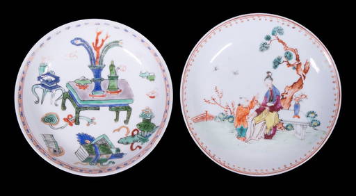
CHINESE KANGXI PERIOD PORCELAIN SAUCERSThomaston Place Auction Galleries4.4(386)See Sold PriceFeb 24, 2024
CHINESE NANKING CARGO CUP & SAUCERThomaston Place Auction Galleries4.4(386)See Sold PriceFeb 24, 2024
PAIR (18th c) OF FLINTLOCK DUELING PISTOLSJohn McInnis Auctioneers,LLC4.6(502)See Sold PriceFeb 24, 2024
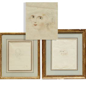
DR. FJ HOLBEN PAINTED TRADE SIGN SIGNED RJ WERSYJohn McInnis Auctioneers,LLC4.6(502)See Sold PriceFeb 25, 2024
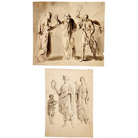
2 Pieces 18th C Cherub Terracotta Sculptures putti terra cotta cherubs on marble plinth, dated 1735Neely Auction4.6(224)See Sold PriceFeb 25, 2024
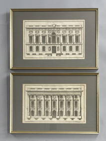
2 Framed 18th C. Parisian Architectural PrintsEpic Auctions and Estate Sales4.6(204)See Sold PriceMar 02, 2024
Fine Chinese Blue and White Silk Embroidered Gauze Textile, 18th C.Material Culture4.6(765)See Sold PriceFeb 29, 2024
Willem Blaeu, Etc. 17th C. Antiquarian Maps, 2Auctions at Showplace4.5(726)See Sold PriceMar 17, 2024
18Th C. Continental 2 Door Wardrobe Cupboard Hand CarvedRalph Fontaine Heritage Auctions Inc.4.7(235)See Sold PriceFeb 25, 2024
Two (2) Antique 18th C. Copper Engraved Framed Maps - America & EuropeMagnusson Art Group4.5(46)See Sold PriceMar 14, 2024
Map: An 18thC engraved and hand coloured map of Northamptonshire, with description ofClaydon Auctioneers Ltd4.3(125)See Sold PriceFeb 26, 2024
Map: An 18thC engraved and hand coloured map of North America and South America, titled DeClaydon Auctioneers Ltd4.3(125)See Sold PriceFeb 26, 2024
Map: An 18thC engraved map of Bedfordshire titled An Accurate Map of the County of Bedford DividedClaydon Auctioneers Ltd4.3(125)See Sold PriceFeb 26, 2024
1758 MAP PARTIE DE LA MER GLACIALE contenants La Nouvelle Zemble RUSSIA antiqueJasper524.5(9.8k)See Sold PriceFeb 27, 2024
ANTIQUE ROMAN ARMORIAL VELLUM BINDING, 1744, ILLUSTRATED WITH AN ANTIQUE MAP BY FLORUSNY Elizabeth 4.3(84)See Sold PriceMar 03, 2024
THE WHOLE CHRONICLE OF POLYBIUS ANCIENT IN ENGLISH, 1756NY Elizabeth 4.3(84)See Sold PriceMar 03, 2024


![[2] 18th C. Maps by D'Anville del Sig. Rollin (1 of 13)](https://p1.liveauctioneers.com/3627/179840/92339963_1_x.jpg?height=282&quality=70&version=1604662439)