Sold1st map showing Jedediah Smith's routeHeading: Author: Brué, Adrien Hubert Title: Nouvelle Carte du Mexique, Et D'une Partie des Provinces Unies De L'Amerique Centrale, Dediée á l'Acadamie Royale des Sciences de l'Institute de FranceSee Sold Price
SoldRare 1850 German Emigration MapRare 1850 German Emigration Map Showing Routes to California & Oregon103. [MAP]. SMITH, J[ohn] Calvin & H[enry] S[chenck]. Tanner (after). Neueste Eisenbahn-Kanal-U. Post-Karte f&uSee Sold Price
SoldJedediah Smith by Morgan 1953 1STJedediah Smith and Opening the West by Dale Morgan. 1953 stated first edition with dust jacket unclipped. The Bobbs-Merrill Co., Indianapolis and New York. 458 pp. Illustrated. Pictorial map on endsheSee Sold Price
Dixie Line L & N Louisville & Nashville R.R. Supt.Title: Dixie Line L & N Louisville & Nashville R.R. Supt. Comm. Publication Date: c1945 Cartographer: SMITH, L.E. Publisher: L & N RR Size: 39 X 30 Additional Information: Blueprint route map showingSee Sold Price
SoldNashville Battlefields and TN MapTwo Tennessee related maps. 1st item: A NEW MAP OF TENNESSEE WITH ITS ROADS AND DISTANCES FROM PLACE TO PLACE ALONG THE STAGE AND STEAM BOAT ROUTES by H.P. Tanner, dated 1841, showing counties, canalsSee Sold Price
Smith: Map of Asia [verso] South Central Europe, 1894Map: 1894 Smith Map of Asia [verso] South Central Europe -- Map of Asia Showing its Geopolitical Divisions, and also the Various Routes of Travel between London & India, China & Japan &c. [verso] AustSee Sold Price
SoldSmith: Antique Map of Asia, 1894Map: 1894 Smith Map of Asia [verso] South Central Europe -- Map of Asia Showing its Geopolitical Divisions, and also the Various Routes of Travel between London & India, China & Japan &c. [verso] AustSee Sold Price
Smith: Map of Asia [verso] South Central Europe, 1894Map: 1894 Smith Map of Asia [verso] South Central Europe -- Map of Asia Showing its Geopolitical Divisions, and also the Various Routes of Travel between London & India, China & Japan &c. [verso] AustSee Sold Price
SoldPostal map of New Mexico 1901Heading: (New Mexico) Author: Title: Post Route Map of the Territory of New Mexico: Showing post offices with the intermediate distances and mail routes in operation on the 1st of June 190. Also railSee Sold Price
Road Map Showing Route of the Pacific Highway and OtherTitle: Road Map Showing Route of the Pacific Highway and Other Chief Roads of California Publication Date: 1926 Cartographer: ANONYMOUS Publisher: PACIFIC HIGHWAY ASSOCIATION OF CALIFORNIA Size: 17.25See Sold Price
SoldVan der Aa map showing route to British coloniesTitle: 't Noorder Gedeelte van Virginie door Bartholomeus Gosnol en Martin Pringe uyt Engeland Bevaaren Author: Van der Aa, Pieter Description: Copper-engraved map. 15x23 cm. (6x9").North Atlantic andSee Sold Price
SoldMap Showing Routes of the Pacific Coast SteamshipReserve Reduced! Title/Content of Map: Map Showing Routes of the Pacific Coast Steamship Company. Date: 1887-02-01 Cartographer: RAND, MCNALLY & CO. Publisher: PACIFIC COAST STEAMSHIP CO. Size: 26.75See Sold Price
SoldMen Under The Sea – Frank Meier 1948Men Under The Sea by Frank Meier. Dell Adventure softcover, 1948, 144 pages. Some creasing and wear to cover. Map showing route of Fleetwing Expedition on back.See Sold Price
Sold4 Maps of South During Civil WarDESCRIPTION: Four maps of the south during the Civil War. Includes "Map Showing Route of Marches of the Army of General W.T. Sherman from Atlanta, GA to Goldsboro, N.C.", "Map Illustrating the Siege oSee Sold Price
SoldThe Granville Inn and Golf CourseHeading: (Granville Golf Course) Author: Title: Road Map Showing Route to The Granville Inn and Golf Course Place Published: Granville, OH Publisher:The Granville Inn and Golf Course Date PublisSee Sold Price
1897 Rand McNally Map of Pacific Northwest -- MapTitle/Content of Map: 1897 Rand McNally Map of Pacific Northwest -- Map Showing Routes of the Pacific Coast Steamship Company Cartographer: Rand McNally Year/Place: 1897, Chicago Size: 27 X 12.6 in. TSee Sold Price
Sold1900 California Railroad MapCalifornia. Railroad map centered roughly at Sacramento. Engraved date 1900.Steel. 4 x 4 inches. Railroad map showing routes from Oakland to Oroville, California with shorter routes connecting SacrameSee Sold Price
1897 Rand McNally Map of Pacific Northwest -- MapTitle: 1897 Rand McNally Map of Pacific Northwest -- Map Showing Routes of the Pacific Coast Steamship Company Cartographer: Rand McNally Year / Place: 1897, Chicago Map Dimension (in.): 27 X 12.6 in.See Sold Price
1897 Rand McNally Map of Pacific Northwest -- MapTitle: 1897 Rand McNally Map of Pacific Northwest -- Map Showing Routes of the Pacific Coast Steamship Company Cartographer: Rand McNally Year/Place: 1897, Chicago Map Dimensions (in.): 27 X 12.6 in.See Sold Price
1897 Rand McNally Map of Pacific Northwest -- MapTitle/Content of Map: 1897 Rand McNally Map of Pacific Northwest -- Map Showing Routes of the Pacific Coast Steamship Company Cartographer: Rand McNally Year/Place: 1897, Chicago Size: 27 X 12.6 in. TSee Sold Price
Map Showing the Route of the Ohio & Pennsylvania Rail -Publication Date: 1849 Title: Map Showing the Route of the Ohio & Pennsylvania Rail - Road Cartographer: ROBERTS, SOLOMON W. Publisher: OHIO & PENNSYLVANIA R.R. Height: 9.3 Width: 15 "to connect PittsSee Sold Price
Map Showing the Route of the Ohio & Pennsylvania Rail -Title/Content of Map: Map Showing the Route of the Ohio & Pennsylvania Rail - Road Date Printed: 1849 Cartographer: ROBERTS, SOLOMON W. Material/Medium: OHIO & PENNSYLVANIA R.R. Size: 9.3X15 "to conneSee Sold Price
Map Showing the Route to the Mountain and Sea SideTitle/Content of Map: Map Showing the Route to the Mountain and Sea Side Resorts Chesapeake and Ohio Route Date: 1900 Cartographer: THE MATTHEWS NORTHRUP CO. Publisher: THE MATTHEWS NORTHRUP CO. Size:See Sold Price
SoldWorld map showing trade routes to the Indies, 1674Heading: Author: Du Val, Pierre Title: Carte Universelle du Commerce, c'est a dire Carte Hidrographique, ou sont Exactement Decrites, les Costes des 4 Parties du Monde... Place Published: Paris PubliSee Sold Price
Lake Superior and Mississippi River RR 1869 Seven Percent Bonds Book/Report-1869JM Hobby Supply and Railroad Artifact Auctions4.4(126)See Sold PriceFeb 24, 2024
Ohio and Pennsylvania RR 1st Annual Report-1849JM Hobby Supply and Railroad Artifact Auctions4.4(126)See Sold PriceFeb 24, 2024
Union Pacific RR Map of the United States-1926JM Hobby Supply and Railroad Artifact Auctions4.4(126)See Sold PriceFeb 24, 2024
Union Pacific RR Across The Continent West From Omaha, NE Book-April 2, 1868JM Hobby Supply and Railroad Artifact Auctions4.4(126)See Sold PriceFeb 24, 2024
Autobiography Mark Rutherford Dissenting Minister 1st ed 1881 Scarce CalfLuis Porretta Fine Arts4.3(10)See Sold PriceMar 02, 2024
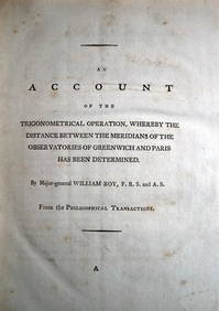
WILLIAM ROY Rare Navigation Book c1797 Trigonometry Between Paris & GreenwichLuis Porretta Fine Arts4.3(10)See Sold PriceMar 02, 2024
HENSHAW 40 x Drawings by Godfrey Miller 1962 First Edition Scarce!Luis Porretta Fine Arts4.3(10)See Sold PriceMar 02, 2024
MARGARET LAURENCE A Jest Of God 1966 1st First Edition Dust Wrapper Near Fine!Luis Porretta Fine Arts4.3(10)See Sold PriceMar 02, 2024
Group of New York Central Railroad Paper - Rule Books, Employee Timetables, Stationary, Log Books,Rail & Road Auctions4.6(165)See Sold PriceMar 07, 2024
Four White Pass & Yukon Route Playing Card DecksRail & Road Auctions4.6(165)See Sold PriceMar 08, 2024
WEST AFRICA Explorers' routes Senegal Ashanti. Mountains of Kong. SDUK 1857 mapJasper524.5(9.8k)See Sold PriceFeb 28, 2024
WEST AFRICA explorers' routes. Beaufort Gray Park Dochard Caillie. SDUK 1874 mapJasper524.5(9.8k)See Sold PriceFeb 28, 2024
WEST AFRICA I Explorers' routes Senegal Ashanti Ivory Gold Coast. SDUK 1851 mapJasper524.5(9.8k)See Sold PriceFeb 28, 2024
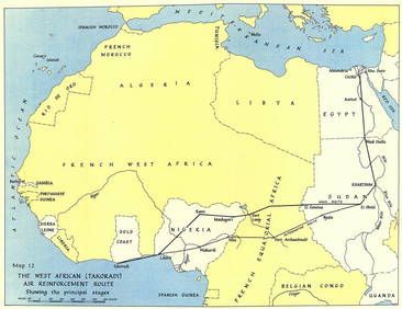
West Africa WW2 Nigeria Sudan Egypt. Takoradi air reinforcement route 1954 mapJasper524.5(9.8k)See Sold PriceFeb 28, 2024
WEST AFRICA showing early explorers' routes & Mountains of Kong. SDUK 1844 mapJasper524.5(9.8k)See Sold PriceFeb 28, 2024


![Smith: Map of Asia [verso] South Central Europe, 1894 (1 of 2)](https://p1.liveauctioneers.com/5584/103242/52831702_1_x.jpg?height=282&quality=70&version=1493321322)

![Smith: Map of Asia [verso] South Central Europe, 1894 (1 of 2)](https://p1.liveauctioneers.com/5584/105261/53910610_1_x.jpg?height=282&quality=70&version=1497542970)