Sold19th century dictionary with various maps and colo19th century dictionary with various maps and coloured illustrationsSee Sold Price
Sold19th century dictionary with various maps19th century dictionary with various maps and coloured illustrationsSee Sold Price
Soldmap book19th century Barclays dictionary with various maps and colured illustrationsSee Sold Price
Thirty-three prints of maps-19th century-variLot #0614: Thirty-three prints of maps 19th century various countries including several maps of "The Upper Territories of the United States" 14 1/4" x 11 1/2" through 12 3/4" x 15" Est 700-1,000See Sold Price
Sold[CANADA & NORTH AMERICA] A collection of 13 maps[CANADA & NORTH AMERICA] A collection of 13 engraved maps. Early 19th century. Various dimensions (approx. 30 x 25 cm). Various conditions. Includes: Northern Hemisphere, Illman & Pilbrow. New York. *See Sold Price
Sold25-19th century maps of the United StatesTitle: Lot of various 19th century maps of North America or the United States Author: ** Description: Includes approximately 20 maps of various sizes and of different regions within the North America.See Sold Price
Sold9 Maps: Africa, 1700's - 1800's.[Africa]. 9 Maps. Various sizes, 18th – 19th century. Condition varies, mostly very good, some light toning, foxing, and dampstain. Few with outline color. ++ H. Liebaux. Carte De L’Afrique PropreSee Sold Price
Sold8 maps of Russia and Asia, c1746-1800[Asia]. 8 Maps. 18th - early 19th century. Various sizes, all folio, largely in very good condition. ++ Robert de Vaugondy. 2 maps: ''L'Asie'' and ''Siberie Ou Russie Asiatique, Tartarie Chinoise, PaySee Sold Price
SoldThree 19th Century Maps of Asia, various sizes, eachThree 19th Century Maps of Asiaeach a colour outlined lithograph showing the continent from Africa to the Pacific, and from the East Indies to the ArcticJohn Pinkerton (1758-1826)ASIA, from Pinkerton'See Sold Price
SoldVarious. 28 maps of Africa. c.19th century.[Africa] 28 maps. Various maps of Africa mostly 19th century. (1) Lapie. “Afrique Ancienne.” 1812. (2) Johnston. “Egypt and Arabia Petraea.” c.1850. (3) Harrison. “EgyptSee Sold Price
SoldHand-Colored 19th Century United States Maps(Lot of 34) Assorted hand-colored 19th century United States maps, (4) Various San Francisco historical business documents, (19) Assorted prints from publications depicting history and geography of thSee Sold Price
COLLECTION OF NINE MAPS Various origins, 16th to 19thCOLLECTION OF NINE MAPS Various origins, 16th to 19th century. Engravings, coloured, on paper; partly verso with latin text. Sheet size min. ca. 19 x 25 cm / max. 56,5 x 65 cm. Part. spotty, brownish,See Sold Price
José Toral (1874 - 1935) - El Sitio de ManilaManila: Imprenta Litografia Partier, 1898 This scarce Manila imprint contains 4 rarely seen maps of various parts of 19th century Manila.See Sold Price
Sold19th Century English School. "Comitatus Rotelandiae,19th Century English School. "Comitatus Rotelandiae, Tabula Nova & Aucta", Map, Unframed, 11.25" x 14.25", and Six other various Maps of the UK, Seven (7).See Sold Price
SoldA Collection og Mainly 19th Century Maps of CentralVarious maps including some part maps x7See Sold Price
Sold19th Century English School. "North Africa/ South19th Century English School. "North Africa/ South Africa", Map, Drawn and Engraved for Thomson's New General Atlas 1815, Unframed, 23" x 20.25", and Ten other various Maps, Eleven, (11)See Sold Price
SoldVarious. 41 maps of Europe. c.19th century.[Europe] 41 maps. Various maps of Europe and the countries therein, mostly 19th century. (1) “The Expedition of Hannibal.” (2) “Delineatio Urbis Nidrosiae vulgo Dronheem.” 1658See Sold Price
SoldVarious. 16 maps of the Middle East. 17-19th cent.[Near/ Middle East] 16 maps. Various maps of the Near and Middle East, mostly 19th century. (1) [After Ptolemy] “Tabula Asiae V.” c. 17th century. Weller, Edward. (2) “The Isthmus ofSee Sold Price
SoldMAPS: Group of 10 maps of Australia, 19th & 20thMAPS: Group of 10 maps of Australia, 19th & 20th century. Various sizes.See Sold Price
Sold14 maps of Asia/Pacific Islands. c.19th century.[Asia] 14 maps. Various maps of Asia and the Pacific Islands mostly 19th century. (1) Vosgien. “Asie avec le Nouvelles Dimensions.” c.1810. (2) Thompson, John. “Map of the Islands inSee Sold Price
Sold[Map Miscellany]. About 35 Maps. Various countrie[Map Miscellany]. About 35 Maps. Various countries; cities, regions. Mostly 19th century; excised from various editions. Some in tatters. Sold on floor only. This is a live auction at our physical aucSee Sold Price
SoldASSORTED PRESSED GLASS INDIVIDUAL OPEN SALTS, LOT OF 36ASSORTED PRESSED GLASS INDIVIDUAL OPEN SALTS, LOT OF 36, colorless, including Atlas and Fostoria American. 19th/20th century. Various sizes.Most undamaged, some with normal chipping/wear.Provenance: FSee Sold Price
Sold24 misc. Maps on Europe/World. 18th-19th century.[Various] 24 maps. Miscellaneous group of 24 18th-19th century maps depicting Europe and the World. Measurements range from approximately 10” x 7 3/4” to 21 1/4” x 15 5/8”. A fSee Sold Price
SoldA mixed group of 19th century and early 20th centuA mixed group of 19th century and early 20th century maps,including various country and world maps, engravings, lithographs, v.s., foxing, some tears, 19th and early 20th century(173)See Sold Price
Illustrated Sabbath Cloth - Holy Sites of Eretz IsraelLevy Auction House4.3(11)See Sold PriceFeb 27, 2024
1849 Mitchell School ATLAS 24 MAPS America Holy Land France Africa Egypt AsiaSchilb Antiquarian Rare Books4.8(428)See Sold PriceMar 31, 2024
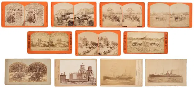
[EPHEMERA]. A Group of Various Ephemera. [V.p., ca. 19th - ...Potter & Potter Auctions4.6(545)See Sold PriceMar 07, 2024
A COLLECTION OF VARIOUS 19TH CENTURY PEARLWARE ITEMSHutchinson Scott Auctioneers4.4(42)See Sold PriceFeb 28, 2024
A 19TH CENTURY HAND COLOURED MAP OF ORKNEY AND SHETLANDHutchinson Scott Auctioneers4.4(42)See Sold PriceFeb 28, 2024
Mitchell - Map of the City of Washington (Washington, DC)Trillium Antique Prints & Rare Books4.5(32)See Sold PriceFeb 24, 2024
Nottingham.- Ordnance Survey Office (publisher) Collection 8 geological maps on the environs ofForum Auctions4.3(53)See Sold PriceFeb 29, 2024
Johnson's Africa. Colonies & tribes. Liberia Nile Delta Cape Colony 1866 mapJasper524.5(9.9k)See Sold PriceFeb 28, 2024
West Africa. Sahara caravan routes. Tribes Kingdoms Empires. LIZARS 1842 mapJasper524.5(9.9k)See Sold PriceFeb 28, 2024
Afrique Ancienne. Ancient North Africa. MALTE-BRUN c1871 old antique map chartJasper524.5(9.9k)See Sold PriceFeb 28, 2024
Two Hand-Colored 19th Century Maps of New Orleans and Louisiana, Larger- H.- 12 1/2 in., W.- 15 1/2Crescent City Auction Gallery4.3(231)See Sold PriceMar 08, 2024
Ernst Ewald (1842-1916) - Set of 12 Prints - Ceiling of a vestibule in a commercial house, Germany -Proverde Auctions4.3(3)See Sold PriceFeb 28, 2024
Joseph Williamson Ludlow (1840 - 1916) - Set of 2 Bird Prints - Aylesbury Ducks - Toulouse GeeseProverde Auctions4.3(3)See Sold PriceFeb 28, 2024
Joseph Williamson Ludlow (1840 - 1916) - Set of 2 Bird Prints - White-faced black Spanish - WhiteProverde Auctions4.3(3)See Sold PriceFeb 28, 2024


![[CANADA & NORTH AMERICA] A collection of 13 maps (1 of 2)](https://p1.liveauctioneers.com/1124/187577/94368854_1_x.jpg?height=282&quality=70&version=1607095126)


![[EPHEMERA]. A Group of Various Ephemera. [V.p., ca. 19th - ... (1 of 1)](https://p1.liveauctioneers.com/928/318880/171361562_1_x.jpg?height=282&quality=70&version=1707501302)