Sold9 Maps: Africa, 1700's - 1800's.[Africa]. 9 Maps. Various sizes, 18th – 19th century. Condition varies, mostly very good, some light toning, foxing, and dampstain. Few with outline color. ++ H. Liebaux. Carte De L’Afrique PropreSee Sold Price
Sold24 misc. Maps on Europe/World. 18th-19th century.[Various] 24 maps. Miscellaneous group of 24 18th-19th century maps depicting Europe and the World. Measurements range from approximately 10” x 7 3/4” to 21 1/4” x 15 5/8”. A fSee Sold Price
SoldPair Antique 19th Century Atlases, Bound MapsPair Antique 19th Century Atlases. ‘Mitchell’s New General Atlas Containing Maps of Various Countries of the World, Plans of Cities, Etc.’ published by S. Augustus Mitchell, Jr. c 1860. ‘AtlasSee Sold Price
SoldPair Antique 19th Century Atlases, Bound MapsPair Antique 19th Century Atlases. ‘Mitchell’s New General Atlas Containing Maps of Various Countries of the World, Plans of Cities, Etc.’ published by S. Augustus Mitchell, Jr. c 1860. ‘AtlasSee Sold Price
Sold19 Geography textbooks from the 19th centuryHeading: (Atlases) Author: Title: Nineteen Geography textbooks from the 19th century Place Published: [Various places] Publisher: Date Published: [Mostly 1800's] Description:See Sold Price
SoldGrp: 54 Maps of the World 18th and 19th c.Group of 54 maps of various regions of the world, dating from the 18th and 19th century. Foldable Map of Navarre on paper attached to linen, Tomás López de Vargas Machuca (1730-1802) "Map of theSee Sold Price
SoldChina Missions, late 19th century, a small box ofChina Missions, late 19th century, a small box of various China Missionary items and ephemera, including a tissue paper map, passport to Rev. A W Nightingale expiring 1880, signed 'Bullock', printed sSee Sold Price
SoldBox of atlases and other itemsHeading: (Atlases) Author: Title: Group of partial and disbound atlases, atlas maps, pictorial weeklies, etc. Place Published: Various places Publisher: Date Published: 19th century to 1901<See Sold Price
SoldCollection of 19th Century mapsVarious engravers and publishers including Augustus Mitchell A.J. Johnson New York, Taintor Bros & Merrill are a few. See photos for details. Fair to good condition as shown. Also a great 1832 by BaldSee Sold Price
SoldMap and Print AssortmentMap and Print Assortment Approximately (12) pounds of 17th-19th century engravings, etchings and mezzotints, some hand-colored, by various artists including Phillipe de la Rue, Edward Rooker, and AdriSee Sold Price
SoldLarge Collection of 19th Century MapsVarious makers, engravers and publishers. See photos for details. Fair to good condition as shown. George CRAM, Johnsons Georgia and Alabama, Johnsons and Ward NEW YORK, J.H. Colton South Carolina andSee Sold Price
SoldLot of thirty Ojime. Japan. 19th century. VariousLot of thirty Ojime. Japan. 19th century. Various materials and subject matters. All items in session one were collected by William H. Smith (1853-1923)See Sold Price
SoldEarly 19th Century Map of LouisianaEarly 19th Century Map of Louisiana(Baltimore: F. Lucas, 1817), engraving with outline color, depicts adjacent areas in Mississippi, Alabama, Florida, Texas and Arkansas (being labeled "Missouri"). PrSee Sold Price
Sold19th century maps(lot of 4) 19th century maps of different sections of Paris, overall (framed/each): 21.5"h x 27.25"wSee Sold Price
SoldEarly 19th Century Map of Ontario and Yates County byEarly 19th Century Map of Ontario and Yates County by David H. Burr Sight 17 x 16 in. The estate of Dr. Seymour Ira Schwartz, Rochester, New York.See Sold Price
SoldEleven (11) 19th Century MapsIncluding Map of the State of Arkansasby TAINTOR BROS & MERRILL, Map of Wisconsin by Geo. F Cram, Johnson's NEW BRUNSWICK Nova Scotia, NEWFOUNDLAND and Prince Edward P. By Johnson and Ward Washington,See Sold Price
Sold(2) 19TH CENTURY MAPS OF MARYLAND, VIRGINIA, ETC.Includes: (1) "Map of Virginia and Maryland - Constructed from the Latest Authorities", dated 1825; published by A. Finley, Phila. 1824; engraved by J. H Young; Drawn by D H. Vance; exhibits the whiteSee Sold Price
Sold(4) 19th Century Map Engravings.(4) 19th C. map engravings. A New and Accurate map of Europe. Drawn from the best Authorities, assisted by the most approved Charts and Maps and adjusted by Astronomical Observations by Eman Bowen;See Sold Price
Sold19th Century Map - A Plan of the Town, New HavenMap of plan of New Haven. Paper in linen. 19th century. Map opening size : H 7-3/4", W 6"; frame size: H 14", W 12". Excellent condition. Professionally framed. Collection of Laura Mitler. Please refeSee Sold Price
SoldTHREE 19TH CENTURY MAPS OF UTAHIncludes two 'by order of the honorable the Secretary of War,' and assisted by G.K. Gilbert, A.R. Marvine, E.E. Howell, and based on expeditions of 1872 and 1873. Both with sight sizes of approximatelSee Sold Price
SoldWall Maps. Two rolled 19th century maps mounted onWall Maps. Two rolled 19th century maps mounted on linen, for instructional use, one of the United States, and the other of Worcester County, some cracking and discoloration.See Sold Price
SoldLot of 12 Early 19th Century MapsMostly by Jeffery's. Depicting the East Indies, Germany and surround, Asia, Africa, "Turky in Asia" , Italy and surround, Spain & Portugal, early North America, France, South America, Europe, and HungSee Sold Price
Sold19TH CENTURY MAPS OF ENGLAND, PRUSSIAN, AND AUSTRIAN19TH CENTURY MAPS INCLUDING ENGLAND BY GALLS AND IGLIS, PRUSSIAN DOMINIONS, AND AUSTRIAN EMPIRES ALONG WITH A COLLECTION OF SLAVIC CURRENCY INCLUDING CZECH KORUNA AND HUNGARIAN FORINTS OF DIFFERENT DOSee Sold Price
SoldFRAMED LATE 19TH CENTURY MAP OF FLORIDAA photo print of the state of Florida published by George F. Cram of Chicago, Ilinois. Dates from between 1885 and 1905, as it includes the Florida East Coast Railway to Miami, but not the Overseas RaSee Sold Price
Illustrated Sabbath Cloth - Holy Sites of Eretz IsraelLevy Auction House4.3(11)See Sold PriceFeb 27, 2024
1849 Mitchell School ATLAS 24 MAPS America Holy Land France Africa Egypt AsiaSchilb Antiquarian Rare Books4.8(428)See Sold PriceMar 31, 2024
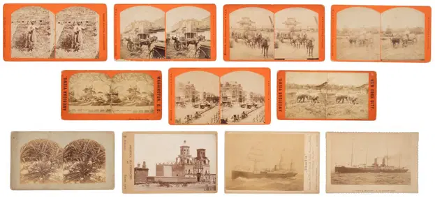
[EPHEMERA]. A Group of Various Ephemera. [V.p., ca. 19th - ...Potter & Potter Auctions4.6(545)See Sold PriceMar 07, 2024
A COLLECTION OF VARIOUS 19TH CENTURY PEARLWARE ITEMSHutchinson Scott Auctioneers4.4(42)See Sold PriceFeb 28, 2024
A 19TH CENTURY HAND COLOURED MAP OF ORKNEY AND SHETLANDHutchinson Scott Auctioneers4.4(42)See Sold PriceFeb 28, 2024
Mitchell - Map of the City of Washington (Washington, DC)Trillium Antique Prints & Rare Books4.5(32)See Sold PriceFeb 24, 2024
Nottingham.- Ordnance Survey Office (publisher) Collection 8 geological maps on the environs ofForum Auctions4.3(53)See Sold PriceFeb 29, 2024
Johnson's Africa. Colonies & tribes. Liberia Nile Delta Cape Colony 1866 mapJasper524.5(9.9k)See Sold PriceFeb 28, 2024
West Africa. Sahara caravan routes. Tribes Kingdoms Empires. LIZARS 1842 mapJasper524.5(9.9k)See Sold PriceFeb 28, 2024
Afrique Ancienne. Ancient North Africa. MALTE-BRUN c1871 old antique map chartJasper524.5(9.9k)See Sold PriceFeb 28, 2024
Two Hand-Colored 19th Century Maps of New Orleans and Louisiana, Larger- H.- 12 1/2 in., W.- 15 1/2Crescent City Auction Gallery4.3(231)See Sold PriceMar 08, 2024
Ernst Ewald (1842-1916) - Set of 12 Prints - Ceiling of a vestibule in a commercial house, Germany -Proverde Auctions4.3(3)See Sold PriceFeb 28, 2024
Joseph Williamson Ludlow (1840 - 1916) - Set of 2 Bird Prints - Aylesbury Ducks - Toulouse GeeseProverde Auctions4.3(3)See Sold PriceFeb 28, 2024
Joseph Williamson Ludlow (1840 - 1916) - Set of 2 Bird Prints - White-faced black Spanish - WhiteProverde Auctions4.3(3)See Sold PriceFeb 28, 2024


![[EPHEMERA]. A Group of Various Ephemera. [V.p., ca. 19th - ... (1 of 1)](https://p1.liveauctioneers.com/928/318880/171361562_1_x.jpg?height=282&quality=70&version=1707501302)