Sold(19th c.) Map of Saigon River of Don-Nai"Map of River of Don-Nai from Cape St. James to the City of Saigon" by M. Dayot with 1820 additions by John White USN. 17 x 23 inches. Condition: Folds, small tear mostly to edges, foxingSee Sold Price
19th C Weller Map of River Thames19th Century “The River Thames from Its Source to the Sea”, by Edward Weller. Handcolored outlining. Very Good, measures 25.5 x 19”. Very Good, light tatter. Central fold as issued.See Sold Price
Sold19th C Virginia coastal map of York River.19th C Virginia coastal map of York River. 23 1/2" x 19 1/2".See Sold Price
SoldNorman Tuttle, Hudson River NY mapNorman Tuttle, Hudson River NY map, Norman Tuttle (British, 19th c.) , "Willard's New Map of the Hudson River", c. 1844, pub. Joseph Willard, Kennedy Galleries label verso, 28.5"h x 10.75"w (sight), 3See Sold Price
Sold"General View of the Mississippi River from Cairo,"General View of the Mississippi River from Cairo, Illinois, to the Mouth of the River," Harper's Weekly map, 19th c., framed, H.- 14 1/8 in., W.- 9 1/8 in.See Sold Price
COURSE OF THE RIVER MOLE 19TH C. HAND-COLORED MAPDated 1848. Dimensions: (Frame) H 15" x W 22", (Sight) H 9.5" x W 16.5" Condition: Toning to mat. Crease down center from folding. Light wear to frame.See Sold Price
Sold19th c. Map19th c. map "MAP OF THE HEAD WATERS of the RIVERS/SUSQUEHANNA & DELAWARE/Embracing the EARLY Patents on the South Side of the MOHAWK RIVER/From the Original, drawn about the Year 1790 by Simeon De WitSee Sold Price
Sold19th C. Map. Lt. Cooke's RoadSketch. Lt. Cooke's March and Wagon Road. Part of the March and Wagon Road of Lt. Col. Cooke from Santa Fe to The Pacific Ocean 1846-1847. From a point on the Grande River. 13"H. x 24"W.See Sold Price
SoldJohnson's 19th c. Map of the Vicinity of RichmondHand colored. Full Title: ohnson's Map of the Vicinity of Richmond, Peninsular Campaign in Virginia. Showing also the interesting localities along the James, Chickahominiy and York Rivers. . . ConsideSee Sold Price
Late 19thc Map of Abyssinia, EthiopiaThis detailed map was originally published in Rand, McNally & Co.s Universal Atlas of The World. This colorful map is copyright 1895. This map shows cities and towns, lakes and rivers, and the existinSee Sold Price
SoldThree Southern Regional WorksA Group of Three Southern Regional Works, including two 19th c. maps of Florida; one a survey map for a proposed canal between Espiritu Santo Bay and the St. John's and Ocklawaha rivers, published bySee Sold Price
SoldLot of 4 Russian Books, 19th C. Bible, MapsLot of four likely Russian books with what look like Cyrillic lettering. Includes a Bible and a book of that appears to be about seafaring with a large fold-out river map.Dimensions range from 9.75 inSee Sold Price
Early 19th C Handcolored Map Holy LandHandcolored map of the Holy Land showing territories of the tribes of Israel to the river Jordan. Beautiful circa 1812. Measures 9 x 11.5".See Sold Price
Sold"A New Map of the River Mississippi from the Sea to"A New Map of the River Mississippi from the Sea to Bayougoulas", 19th c., for the London Magazine, framed, H.- 7 5/8 in., W.- 9 7/8 in.See Sold Price
Map of Savannah River Blunt NYMap of Savannah river plate 12th edition of Hunts Coast Pilot, Blunt , NY early 19th c - some foxing and folds as shown -about 9 x 16 . Can be washed and cleaned.See Sold Price
Sold19thc Hand-colored Harper's Weekly Engravings, St.Pair of 1861 Harper's Weekly pages with hand-colored maps & engravings of river boats, The Mississippi River, St Louis & Jefferson City. Four hand-colored engravings total between 2 pages dated July 6See Sold Price
19thc Hand-colored Harper's Weekly Engravings, St.Pair of 1861 Harper's Weekly pages with hand-colored maps & engravings of river boats, The Mississippi River, Â St Louis & Jefferson City. Four hand-colored engravings total between 2 pages dated JuSee Sold Price
SoldPrint LotLot including 19th c. "Cooper House...Cooperstown N.Y." print (sight 19" x 23") and early map of Susquehanna River (sight 15 1/2" x 19").See Sold Price
SoldA Framed 19th C. Harper's Weekly PageA Framed 19th C. Harper's Weekly Page, pages 40 and 41 from the January 18, 1862 issue, featuring a map of the James River near Richmond, Virginia, as well as a print of the city of Richmond, VirginiaSee Sold Price
SoldEuropean Maps, 18th & 19th C. (2)European Maps, 18th & 19th C. (2)Dimensions: 1 is 9" x 13 1/2"; 1 is 12 3/4" x 7"Condition: GoodProvenance: Westchester Co., estateSee Sold Price
SoldTwo Maps of Florida, published by AckermanTwo Maps of Florida , 19th c., one a survey map for a proposed canal between Espiritu Santo Bay and the St. John's and Ocklawaha rivers, published by Ackerman, New York, NY; together with another survSee Sold Price
SoldGray's New Map of Louisiana, 19th c., handcolored, withGray's New Map of Louisiana, 19th c., handcolored, with insets of the City of New Orleans and the Passes of the Mississippi River, presented in an ebonized frame with a gilt liner, H.- 17 1/4 in., W.-See Sold Price
Sold19th C. New Rail Road & County Map of N. CarolinaPublished 1878-1883 probably by George F. Cram; depicts cities, towns, rivers and railroads; inset continuation "Western Part of N. Carolina."; 11 1/2"W, 9"H--Private collection, Spartanburg, South CaSee Sold Price
SoldTraditional Map with Inscription, Korea, 19th C.Ink and color on paper Korea, 19th century Zodiac with designations such as city, mountain and river names Presumably based on the Chinese work ‘classic of mountains and seas’ (Shanhaijing), the oSee Sold Price
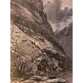
19thc North Carolina Engraving, Farm On The French Broad RiverConnoisseur Auctions4(333)See Sold PriceMar 02, 2024
ENGLISH SCHOOL 19TH C. SUSPENSION BRIDGE OIL ON CANVASOmnia Auctions4.7(324)See Sold PriceFeb 26, 2024
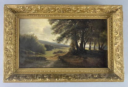
Hudson River School Signed 19th C. Oil PaintingEpic Auctions and Estate Sales4.6(204)See Sold PriceMar 02, 2024
Late 19Th C. French Fine Gilt Rectangular BoxWorld of Antiques, Inc.3.9(74)See Sold PriceFeb 29, 2024
Map: A 19thC engraved and hand coloured map of Buckingham titled A New Map of BuckinghamshireClaydon Auctioneers Ltd4.3(125)See Sold PriceFeb 26, 2024
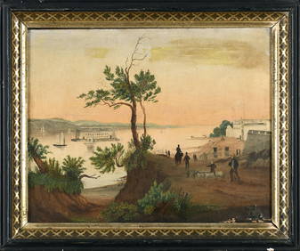
MID 19THC. HUDSON RIVER SCHOOL LANDSCAPE 10 1/2" X 17 1/2"Carlsen Gallery, Inc.4.6(163)See Sold PriceMar 03, 2024
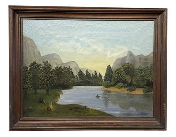
O/C "ALLEGANY INDIANS ALONG THE GENESEE RIVER" 19THC. AMERICAN SCHOOL PRIMITIVE (18" X 24")Carlsen Gallery, Inc.4.6(163)See Sold PriceMar 03, 2024
Rare 19thc Colton Map, Argentine Republic, Chile, Uruguay, PataguayConnoisseur Auctions4(333)See Sold PriceMar 16, 2024