ATLAS of ANTIENT GEOGRAPHY by SAMUEL BUTLER 1843John McInnis Auctioneers,LLC4.5(505)See Sold PriceFeb 24, 2024
18TH C. ANTIQUE MAP: FRENCH & INDIAN WAR, FRAMEDThomaston Place Auction Galleries4.4(393)See Sold PriceFeb 24, 2024
Rand McNally Railroad Map Cabinet w/ 21 Railroad MapsRail & Road Auctions4.6(165)See Sold PriceMar 08, 2024
Keith Haring - Ink on New York Map, Best Buddies, Inscribed, Signed, and DatedSapphire Auction Gallery4.1(67)See Sold PriceMar 02, 2024
LATE 17TH C. FRENCH MAP OF THE NEW WORLD BY ALEXIS-HUBERT JAILLOT (1632-1712)Thomaston Place Auction Galleries4.4(393)See Sold PriceFeb 24, 2024
Central Railroad of New Jersey Map of Sandy Hook Route-ca. 1903JM Hobby Supply and Railroad Artifact Auctions4.4(127)See Sold PriceFeb 24, 2024
Lot of Six Mixed Atlas Box Cars-HO Scale-New in BoxJM Hobby Supply and Railroad Artifact Auctions4.4(127)See Sold PriceFeb 25, 2024
Rand McNally/Santa Fe Railroad Map of Iowa-1912JM Hobby Supply and Railroad Artifact Auctions4.4(127)See Sold PriceFeb 24, 2024
NICOLAES VISSCHER (NETHERLANDS, 1618-1709) MAP OF THE NEW WORLDThomaston Place Auction Galleries4.4(393)See Sold PriceFeb 24, 2024
17TH C. WORLD MAP BY NICOLAES VISSCHER (NETHERLANDS, 1618-1709)Thomaston Place Auction Galleries4.4(393)See Sold PriceFeb 24, 2024
Lot of Six Mixed Atlas Cabooses-HO Scale-New in BoxJM Hobby Supply and Railroad Artifact Auctions4.4(127)See Sold PriceFeb 25, 2024
(2) 19th C. Handcolored Litho Maps of CanadaTwo (2) 19th Century handcolored lithograph maps, including: Johnson's "Upper Canada, Lower Canada, and New Brunswick", circa 1865, 26 1/2" x 18", some toning; "Provinces of Ontario and Quebec, DominiSee Sold Price
Sold(3) Assorted 19th C. Engraving and Litho MapsThree (3) maps, including: circa 1838 hand-colored copper plate engraving, "Ohio", publisher T.G. Bradford, 16 1/4" x 13 1/4", unframed, small edge tears; circa 1855 lithograph, "Colton, Virginia & WeSee Sold Price
SoldMAP:MID 19th C. DOUBLE HEMISPHERE MAP, LITHOArtist: J.H. Brightly, Title: A New Map of the World on the Globular Projection, Pub: Thomas Cowperthwait and Co., Date: 1850, Medium: HC Lithograph, Paper size: 13 1/4 x 17 1/4, Inscribed: PublisherSee Sold Price
19/20th C. Litho Map, Railroads of MA, 1893Late 19th/early 20th Century lithographed map, "Map of the Railroads of the State of Massachusetts 1893" by Geo. H. Walker & Co., Lith., Boston, 27 1/2" x 35 3/4". Some light toning; fold lines.See Sold Price
Staub Map of New OrleansSTAUB News Dealer, New Orleans (Late 19th Century). Map of the City of New Orleans. Lithographed Map by M.F. Dunn & Bros Steam Litho. New Orleans, c. 1884.12 1/4" x 18 3/4" sheet, 21 1/2" x 28" framedSee Sold Price
Sold19th c. MapC. 1828 Geologic profile map from Atlantic to Lake Erie. Stephen Van Relsselaer and Amos Eaton. Includes (4) steel engraved views. Older tape and newer scotch tape seperation repairs at some folds. 8"See Sold Price
Sold19TH C MAP OF FRANCE BEFORE THE REVOLUTIONAntique Map of France before the Revolution divided into Military Governments engraved for J. Bradley's Elements of Geography. Professionally framed and triple matte, silk mat. In frame 17 1/2"x16"x1"See Sold Price
Sold19th c. Map New York City19th c. "Map Of New York And Its Vicinity, New York 1863". Published by S.D. Tildern. 63 1/2" x 63 1/2". Some damage.See Sold Price
Sold19th C. Map of North & South CarolinaEach county individually hand colored; unframed; 14 1/2"W, 12"H; small tears to margins well outside border and map, toningSee Sold Price
Sold19th c. Map of Virginia and Maryland2 19th c. maps of US states 1). Map of Virginia and Maryland with a plan of Washington and Georgetown. 2). Map of Kentucky and Tennessee- both copper engravings, published in London in 1831 by Isaac TSee Sold Price
SoldLate 19th C. Map of Turkish EmpireLate 19th century map of the Turkish Empire, by H. Moll, 26" h x 40" w (view), 28" h x 43" w (frame). Provenance: From a Florida estate.See Sold Price
Sold19TH C. MAP OF MASSACHUSETTS, CONNECTICUT ANDPUBLISHED BY SUMNER & CO. 1833 MAP IS 19" X 15". BOOK IS 3" X 5"See Sold Price
SoldMaris Pacifici , 19th C map of the Pacific region ,Maris Pacifici , 19th C map of the Pacific region , after Ortelius Abrahamus. PROVENANCE: Francis de Sales McHugh Collection. 13 x 19in. (33 x 48cm)See Sold Price
Sold19th C Map Of New York & Vicinity Beers, Ellis &19th century Map Of New York & Vicinity Beers, Ellis & Soule. Measures 32" x 30". Has a few crinkles here and there, overall nice.See Sold Price
Soldlate 19th c litho puzzle block setlate 19th c litho puzzle block set with 5 chromolithographed sheets (one sheet missing), sliding top w/ color litho label, 13" x 9 1/2" x 2 1/2"See Sold Price
Sold(2) Late 19th c. maps of Ireland, unframedTwo late 19th century colored maps of Ireland, comprising a map of Ireland printed for The Century Atlas, circa 1897, 16"h x 11"w, unframed, and a map of Ireland printed for The Society for the DiffusSee Sold Price
Sold19TH C. LITHO TIN ADVERTISING TRAY FOR CHRISTIANFEIGENSPAN BREWERIES, NEWARK, NJ, 13 1/4"D, MINIMAL LOSS TO SURFACE, C. 1910See Sold Price
19th C Map of HindoostanMap: Hindoostan (India) Date: 19th century Map Size: 10 x 12 inches Frame Size: 18 x 20 inches Hindoostan (or Hindustan) is a common geographic term for the northern/northwestern Indian subcontinent.See Sold Price
SoldTWO 19TH C. LITHO TIN TEA BOXES, ONE MARKEDJONSTON BROS. 11 1/2" H, 7 1/2" X 7 1/2"See Sold Price
SoldLg Framed early 19th c. Map of the WorldLg Framed early 19th c. Map of the World, "Mappe Monde", Indication des trois voyages du Capitaine Cook, French 1816 in floral gilt 32" x 46" frame Condition; was folded, some wear along fold lines frSee Sold Price
UNFRAMED 19TH C. MAP OF IRELANDHand Colored Engraving, maker unknown, unframed, 17" x 14" sheet, 12" x 9 1/2" image, shrinkwrapped. Toned, margin indentation, edge tears and bends (would mat out).See Sold Price
SoldLOT OF 6 19TH C MAPS POLYCHROMED CELESTIAL C.1880A grouping of six nineteenth Century maps to include a nicely polychromed celestial map having cherub surround circa 1880. Ht: 24" Width: 27" Depth: 1"See Sold Price
19TH C GERMAN OIL PAINTING BY EMIL ZSCHIMMER C 1872Antique Arena Inc.4.5(878)See Sold PriceFeb 24, 2024
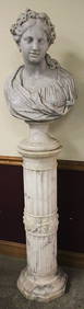
Magnificent 19Th C. Hand Carved Marble Bust And PedestalRalph Fontaine Heritage Auctions Inc.4.7(236)See Sold PriceFeb 25, 2024
Map: A 19thC engraved and hand coloured map of Buckingham titled A New Map of BuckinghamshireClaydon Auctioneers Ltd4.3(125)See Sold PriceFeb 26, 2024
1722 POMPONII MELA De Situ Orbis ARMORIAL VELLUM BINDING antiqueJasper524.5(9.9k)See Sold PriceFeb 27, 2024
1816 MAP SOUTHERN PART OF RUSSIA or MUSCOVY in EUROPE copper engraving ANTIQUEJasper524.5(9.9k)See Sold PriceFeb 27, 2024
1744 ROMAN HISTORY ARMORIAL VELLUM BINDING ILLUSTRATED w/ MAP antique by FLORUSJasper524.5(9.9k)See Sold PriceFeb 27, 2024
1816 MAP NORTHERN PART OF RUSSIA or MUSCOVY in EUROPE copper engraving ANTIQUEJasper524.5(9.9k)See Sold PriceFeb 27, 2024
1758 MAP PARTIE DE LA MER GLACIALE contenants La Nouvelle Zemble RUSSIA antiqueJasper524.5(9.9k)See Sold PriceFeb 27, 2024
1749 MAP CARTE DE LA TARTARIE ORIENTALE RUSSIA & CHINA antique EASTERN TARTARYJasper524.5(9.9k)See Sold PriceFeb 27, 2024
1675 ELZEVIER JULIUS CAESAR antique ILLUSTRATED w/ MAPS ROMAN HISTORYJasper524.5(9.9k)See Sold PriceFeb 27, 2024
1704 DESCRIPTION OF ALL THE SEATS OF THE PRESENT WARS OF EUROPE antique w/ MAPSJasper524.5(9.9k)See Sold PriceFeb 27, 2024
Rare 19thc Colton Map, Argentine Republic, Chile, Uruguay, PataguayConnoisseur Auctions3.9(336)See Sold PriceMar 16, 2024