ATLAS of ANTIENT GEOGRAPHY by SAMUEL BUTLER 1843John McInnis Auctioneers,LLC4.5(505)See Sold PriceFeb 24, 2024
18TH C. ANTIQUE MAP: FRENCH & INDIAN WAR, FRAMEDThomaston Place Auction Galleries4.4(393)See Sold PriceFeb 24, 2024
Rand McNally Railroad Map Cabinet w/ 21 Railroad MapsRail & Road Auctions4.6(165)See Sold PriceMar 08, 2024
Keith Haring - Ink on New York Map, Best Buddies, Inscribed, Signed, and DatedSapphire Auction Gallery4(67)See Sold PriceMar 02, 2024
LATE 17TH C. FRENCH MAP OF THE NEW WORLD BY ALEXIS-HUBERT JAILLOT (1632-1712)Thomaston Place Auction Galleries4.4(393)See Sold PriceFeb 24, 2024
Central Railroad of New Jersey Map of Sandy Hook Route-ca. 1903JM Hobby Supply and Railroad Artifact Auctions4.4(127)See Sold PriceFeb 24, 2024
Lot of Six Mixed Atlas Box Cars-HO Scale-New in BoxJM Hobby Supply and Railroad Artifact Auctions4.4(127)See Sold PriceFeb 25, 2024
Rand McNally/Santa Fe Railroad Map of Iowa-1912JM Hobby Supply and Railroad Artifact Auctions4.4(127)See Sold PriceFeb 24, 2024
NICOLAES VISSCHER (NETHERLANDS, 1618-1709) MAP OF THE NEW WORLDThomaston Place Auction Galleries4.4(393)See Sold PriceFeb 24, 2024
17TH C. WORLD MAP BY NICOLAES VISSCHER (NETHERLANDS, 1618-1709)Thomaston Place Auction Galleries4.4(393)See Sold PriceFeb 24, 2024
Lot of Six Mixed Atlas Cabooses-HO Scale-New in BoxJM Hobby Supply and Railroad Artifact Auctions4.4(127)See Sold PriceFeb 25, 2024
Sold19th c Books, Maps, and PrintsCa 1852 Samuel Goodrich "Peter Parley's Cabinet Library" (17 vols), leather, 6 3/4" x 4 1/4", sold with 1896 MacDowell Woodland Sketches as well as two Handcolored 19th c Lithographs, two 1902 NationaSee Sold Price
SoldK. De Vries, Trompe L'oeil paintingK. De Vries, Trompe L'oeil painting, K. De Vries (Dutch, 19th c.), Maps, prints and book plates, Trompe L'oeil, ink and watercolor on paper, signed and dated "K. De Vries - 18 Jaar - 2nd Ondering (181See Sold Price
SoldLot of ephemera, 19th C. prints, map, Captain NorLot of ephemera, 19th C. prints, map, Captain Norton's orderly book (1898), cdv of black woman. 20th C postcards, photo of JFK, Gene Autry signed Sing Cowboy, Sammy Davis Jr. autograph, British peopleSee Sold Price
SoldThree 19th C. Maps & Two 19th C. Prints**Originally Listed At $100** Europe, Ireland and Germany, ca. 19th century CE. A collection of printed materials: two printed German maps, one print of an older engraved map, and two prints of engravSee Sold Price
Sold3 19th c. American Map BooksThree 19th century American books. 1ST ITEM: 2 Volume set of The History and Topography of the United States, edited by John Howard Hinton, published London by Simpkin & Marshall &Thomas Waddle, PhilaSee Sold Price
Sold6 UNFRAMED PIECES2 19th C. land prints, 2 19th C. maps, Indiana and Ohio, largest approximately 17 3/8" x 28", "Center Church" print, signed Robert E. Esbensen, numbered 10/23, approximate mat size 20" x 16", and prinSee Sold Price
SoldLot of 4 Russian Books, 19th C. Bible, MapsLot of four likely Russian books with what look like Cyrillic lettering. Includes a Bible and a book of that appears to be about seafaring with a large fold-out river map.Dimensions range from 9.75 inSee Sold Price
SoldGERMAN STYLE STILL LIFE20th c. Copy of a 19th c. German Still Life with books, sculpture, prints, ewers and a ginger jar, oil on mahogany panel, initialed "NP" lower right, in black and gold carved frame, OS: 15 3/4" x 17 3See Sold Price
SoldAntique Japanese Wood block print book, 40 pages. 19thAntique Japanese Wood block print book, 40 pages. 19th C. 14" x 9 1/2" wideSee Sold Price
SoldAntique Japanese Wood block print book, 40 pages. 19thAntique Japanese Wood block print book, 40 pages. 19th C. 14" x 9 1/2" wideSee Sold Price
Sold7 19thc School Atlas or Geography map books.A group of 7 American 19th c school atlas or geography books including Mitchell's School Atlas 1839 complete, partial 1829 school atlas, 1854 Smith's Atlas of Modern and ancient geography, 1855 CornelSee Sold Price
SoldLARGE LOT OF (19th c) EPHEMERA(2)Sawyer hand colored photographs of Lake Winnipesaukee, 1794 Copy of 1777 Portsmouth letter, Lloyd Reynolds prints, The Slave's Friend, (19th c) Prints, 1873 Illustrated, maps, pencil drawings, adveSee Sold Price
SoldAntique Copper Engraving Map Asia M Suetter 19th CMap of Asia, colored copper Engraving by M Suetter, circa late 1800s. Originally purchased from Old Maps & Prints Co, Bangkok, for 4,000 baht. Framed in black and gold toned frame, wear and paint lossSee Sold Price
SoldTwo 19th C. Books on World Travel and HistoryIncludes Travels and Adventures of the Most Celebrated Travelers in all Parts of the World by Henry Howe dated 1860 and The Earth Girdled by T. DeWitt Talmadge dated 1896. See photos for condition andSee Sold Price
Sold18th-19th C. Botanical and Nautical printsincludes 4 Botanical plates 1790's by W. Curtis a 19th C. Map of France, Mitchell, 1847. Battle of Trafalgar, October 21st 1805, from 'The Naval Achievements of Great Britain' by James Jenkins, engravSee Sold Price
Sold6 PCS, 18TH & 19TH C MEDICAL BOOKS, LEATHERBOUNDCollection of medical volumes comprising Smith and Horner "Anatomical Atlas - Illustrative of the Structure of the Human Body" -1845, Thomas Dobson "The Elements of Medicine or a Translation of the ElSee Sold Price
SoldGroup of Books and Map of Erie & Nia. Co.Geographical Encyclopedia of Chautaqua County 1891, 1908 Map of Erie and Niagara County by Scarborough Co., Early to Mid 19th C .Autograph Book, Plus other books -See Sold Price
Sold19th c VT books, registers, imprints19th c VT books, registers, & imprints, including Hemenway, Windham Co w/ map,See Sold Price
SoldTWO 19TH C. TRAVEL BOOKS, TO INCLUDEMITCHELLS TRAVEL GUIDE, WITH MAP 1836, TOGETHER WITH POCKET GAZETTEER OR TRAVELER'S GUIDE THROUGH NORTH AMERICAN AND THE WEST INDIES BY BISHOP DAVENPORT BALTIMORE, CUSHING & SONS 1838See Sold Price
SoldJapanese Katsushika Hokusai 19thC. Woodblock BooksKatsushika Hokusai (Japanese,1760-1849). Two Japanese books of woodblock prints from the Hokusai Manga (Ni-hen) series. Dated 1814,1815, and 1843. Assorted illustrations of Japanese culture, lifestyleSee Sold Price
SoldBook of 19thC Japanese Woodblock Prints.Book of 19thC Japanese Woodblock Prints Including 28 Woodblocks. All Signed. Condition: Generally Good Condition. The Book Jacket Needs Attention. Dimensions: 14.75" x 10.5". Provenance: From a Long ISee Sold Price
SoldAntique Hand Colored George Brookshaw Peaches PrintAntique hand colored George Brookshaw peaches print published June 1804. This print was featured in his esteemed "Pomona Brittanica" one of the highest-regarded 19thC. flower books. Approx. image H: 1See Sold Price
Sold18th- 19th c Leather Bound Books18th- early 19th c leather bound books, including Laws, papers, 1749 Prideaux Old & New Testament with fold-out mapsSee Sold Price
Sold19th c. leather bound books incl. Lincoln bioslot of 19th c. leather and cloth bound books including Lincoln biographies, 1845 The Veterinary Surgeon with pull out maps, Francis Parkman The Oregon Trail, New Hampshire Churches, Eulogy of Daniel WSee Sold Price
HONEST JOHN OLIVER by James Morton 1st Edition Inscribed by Author ScarceLuis Porretta Fine Arts4.3(10)See Sold PriceMar 02, 2024
CHARLES KINGSLEY ILLUSTRATIONS BY H.C.SELOUS OF HEREWARD THE WAKE (ART UNION OF LONDON)Luis Porretta Fine Arts4.3(10)See Sold PriceMar 02, 2024
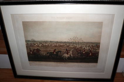
HENRY ALKEN / LEWIS Original 1835 Hand Colored Engraving Quorn Hunt DrawingLuis Porretta Fine Arts4.3(10)See Sold PriceMar 02, 2024
OGILVY & BOWEN c1736 Original Map of Oxfordshire Berkshire Etc.Luis Porretta Fine Arts4.3(10)See Sold PriceMar 02, 2024
Catherwood - General View of Uxmal, Taken from the Archway of Las Monjas, Looking SouthTrillium Antique Prints & Rare Books4.5(32)See Sold PriceFeb 24, 2024
D'Entrecasteaux - Australia: Coasts of Van Diemen's Land (New Holland). 9Trillium Antique Prints & Rare Books4.5(32)See Sold PriceFeb 24, 2024
D'Entrecasteaux - Tasmania, Australia: Map of the Northern Portion of Recherche Bay. 5Trillium Antique Prints & Rare Books4.5(32)See Sold PriceFeb 24, 2024
D'Entrecasteaux - Australia: Chart of Van Diemen's Land (New Holland). 3Trillium Antique Prints & Rare Books4.5(32)See Sold PriceFeb 24, 2024
D'Entrecasteaux - Map of Australia (New Holland), New Zealand, and southern Asia and surroundingTrillium Antique Prints & Rare Books4.5(32)See Sold PriceFeb 24, 2024
Mitchell - Map of the City of Washington (Washington, DC)Trillium Antique Prints & Rare Books4.5(32)See Sold PriceFeb 24, 2024
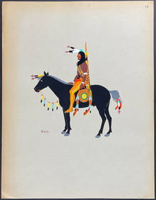
Kiowa Indian Art - Mopope: Kiowa Warrior on HorsebackTrillium Antique Prints & Rare Books4.5(32)See Sold PriceFeb 24, 2024
Kiowa Indian Art - Mopope: Kiowa Warrior and wifeTrillium Antique Prints & Rare Books4.5(32)See Sold PriceFeb 24, 2024
Donovan's The Natural History of British Shells - 5 Volumes in 3 Books with 180 EngravingsTrillium Antique Prints & Rare Books4.5(32)See Sold PriceFeb 24, 2024
Map: A 19thC engraved and hand coloured map of South America. Published by the Society for theClaydon Auctioneers Ltd4.3(125)See Sold PriceFeb 26, 2024
Map: A 19thC engraved and hand coloured map of St. Petersburg / Sanktpeterburga by W. B. Clarke.Claydon Auctioneers Ltd4.3(125)See Sold PriceFeb 26, 2024
Map: A 19thC engraved map titled Gloucestershire from the Best Authorities, after John Cary. Approx.Claydon Auctioneers Ltd4.3(125)See Sold PriceFeb 26, 2024
Map: A 19thC engraved and hand coloured map of Buckingham titled A New Map of BuckinghamshireClaydon Auctioneers Ltd4.3(125)See Sold PriceFeb 26, 2024
Map: A 19thC engraved map of West Riding, titled A Map of the North Part of the West Riding ofClaydon Auctioneers Ltd4.3(125)See Sold PriceFeb 26, 2024