ATLAS of ANTIENT GEOGRAPHY by SAMUEL BUTLER 1843John McInnis Auctioneers,LLC4.5(505)See Sold PriceFeb 24, 2024
18TH C. ANTIQUE MAP: FRENCH & INDIAN WAR, FRAMEDThomaston Place Auction Galleries4.4(393)See Sold PriceFeb 24, 2024
Rand McNally Railroad Map Cabinet w/ 21 Railroad MapsRail & Road Auctions4.6(165)See Sold PriceMar 08, 2024
Keith Haring - Ink on New York Map, Best Buddies, Inscribed, Signed, and DatedSapphire Auction Gallery4.1(67)See Sold PriceMar 02, 2024
LATE 17TH C. FRENCH MAP OF THE NEW WORLD BY ALEXIS-HUBERT JAILLOT (1632-1712)Thomaston Place Auction Galleries4.4(393)See Sold PriceFeb 24, 2024
Central Railroad of New Jersey Map of Sandy Hook Route-ca. 1903JM Hobby Supply and Railroad Artifact Auctions4.4(127)See Sold PriceFeb 24, 2024
Lot of Six Mixed Atlas Box Cars-HO Scale-New in BoxJM Hobby Supply and Railroad Artifact Auctions4.4(127)See Sold PriceFeb 25, 2024
Rand McNally/Santa Fe Railroad Map of Iowa-1912JM Hobby Supply and Railroad Artifact Auctions4.4(127)See Sold PriceFeb 24, 2024
NICOLAES VISSCHER (NETHERLANDS, 1618-1709) MAP OF THE NEW WORLDThomaston Place Auction Galleries4.4(393)See Sold PriceFeb 24, 2024
17TH C. WORLD MAP BY NICOLAES VISSCHER (NETHERLANDS, 1618-1709)Thomaston Place Auction Galleries4.4(393)See Sold PriceFeb 24, 2024
Lot of Six Mixed Atlas Cabooses-HO Scale-New in BoxJM Hobby Supply and Railroad Artifact Auctions4.4(127)See Sold PriceFeb 25, 2024
1947 World Route Map of US Flag Airlines --Title/Content of Map: 1947 World Route Map of US Flag Airlines -- International Air Routes of U.S. Flag Carriers as of April, 1947 Date: 1947 Cartographer: Anonymous Size: 10.9 x 21 in. This fascinatiSee Sold Price
Sold1947 World Route Map of US Flag Airlines --Title/Content of Map: 1947 World Route Map of US Flag Airlines -- International Air Routes of U.S. Flag Carriers as of April, 1947 Date: 1947 Cartographer: Anonymous Size: 10.9 x 21 in. This fascinatiSee Sold Price
1947 World Route Map of US Flag Airlines --Title/Content of Map: 1947 World Route Map of US Flag Airlines -- International Air Routes of U.S. Flag Carriers as of April, 1947 Date: 1947 Cartographer: Anonymous Size: 10.9 x 21 in. This fascinatiSee Sold Price
1947 World Route Map of US Flag Airlines --Title/Content of Map: 1947 World Route Map of US Flag Airlines -- International Air Routes of U.S. Flag Carriers as of April, 1947 Date: 1947 Cartographer: Anonymous Size: 10.9 x 21 in. This fascinatiSee Sold Price
MAPS - US & Canada. Trans-Canada Air LinesUnited States & Canada. Trans-Canada Air Lines, [Lot of 3] TCA Air Route Maps [and] Trans-Canada Air Lines Air Canada [and] Route Map Vancouver to Amsterdam, 1950-60 (circa). Printed Color. This lot iSee Sold Price
SoldAir France. Airlines System World Map.Boucher, Lucien (French, 1889-1971). Air France. Airlines System World Map. Paris: Perceval, 1947. Color offset map of the worldwide service routes of Air France on a dark brown background. 24 ¾See Sold Price
SoldPoster LUCIEN BOUCHER. LUCIEN BOUCHER AIR FRANLUCIEN BOUCHER. AIR FRANCE. 1947. 23 3/4x38 1/4 inches. Perceval, Paris. Condition A-: vertical folds in image. World map in brown, black, green, red, and blue showing the routes of the airliSee Sold Price
SoldTravel Poster Sabena Belgian World Airlines Route MapOriginal vintage travel advertising poster - Sabena - Belgian World Airlines - World map showing the flying routes served by Sabena to Europe, North America, Africa and Asia. The Societé Anonyme BeSee Sold Price
1940s American Airlines US Route Map -- AmericanTitle: 1940s American Airlines US Route Map -- American Airlines System Map Cartographer: American Airlines (General Drafting Co.) Year/Place: 1940s c. Size: 24 X 32 in. Description: Ths is an attractSee Sold Price
1940s American Airlines US Route Map -- AmericanTitle/Content of Map: 1940s American Airlines US Route Map -- American Airlines System Map Cartographer: American Airlines (General Drafting Co.) Year/Place: 1940s c. Size: 24 X 32 in. Ths is an attraSee Sold Price
1940s American Airlines US Route Map -- AmericanTitle/Content of Map: 1940s American Airlines US Route Map -- American Airlines System Map Date: 1940s c. Cartographer: American Airlines (General Drafting Co.)Size: 24 X 32 in. Ths is an attractive fSee Sold Price
SoldAmerican Airlines Route Map World's Fair Line 1939American Airlines Route Map World's Fair Line 1939See Sold Price
SoldVintage Air France Airline Travel Routes World MapVintage Air France Airline Travel Routes World Map, by Lucien Boucher (French, 1889-1971) color offset, C.1948. Framed. Size: 19.5'' x 33.75'', 50 x 86 cm (sight); 24.5'' x 39'', 62 x 99 cm (frame).See Sold Price
SoldAdvertising Poster Air France Airline Planisphere RouteOriginal vintage illustrated planispere world route map issued by Air France, titled Reseau Aerien Mondial (Global Air Network), designed by Lucien Boucher. Continents and major cities are marked on tSee Sold Price
Two 1947 c. American Airlines and Western AirlinesTitle/Content of Map: Two 1947 c. American Airlines and Western Airlines Route Map Ads Date: c. 1947 Cartographer: American Airlines and Western Airlines Size: 14 X 10.3 in. and 10 X 6.8 in. These areSee Sold Price
Two 1947 c. American Airlines and Western AirlinesTitle/Content of Map: Two 1947 c. American Airlines and Western Airlines Route Map Ads Date: c. 1947 Cartographer: American Airlines and Western Airlines Size: 14 X 10.3 in. and 10 X 6.8 in. These areSee Sold Price
Two 1947 c. American Airlines and Western AirlinesTitle/Content of Map: Two 1947 c. American Airlines and Western Airlines Route Map Ads Date: c. 1947 Cartographer: American Airlines and Western Airlines Size: 14 X 10.3 in. and 10 X 6.8 in. These areSee Sold Price
Two 1947 c. American Airlines and Western AirlinesTitle: Two 1947 c. American Airlines and Western Airlines Route Map Ads Cartographer: American Airlines and Western Airlines Year / Place: c. 1947 Map Dimension (in.): 14 X 10.3 in. and 10 X 6.8 in. TSee Sold Price
Mexican National Railway & Texas Mexican RailwayTitle: La Golondrina Author: [Mexican National Railway and Texas Mexican Railway] Description: 4 pp. Color front cover illustration with Mexican and U.S. Flag. Back cover with map of the routes of theSee Sold Price
Mexican National Railway & Texas Mexican RailwayTitle: La Golondrina Author: [Mexican National Railway and Texas Mexican Railway] Description: 4 pp. Color front cover illustration with Mexican and U.S. Flag. Back cover with map of the routes of theSee Sold Price
Travel Poster Sabena Airline Route Map AfricaOriginal vintage Sabena travel advertising poster featuring a map of Europe and Africa designed by Dohet C Pub showing the airline's routes around the world marking the continents, countries, cities aSee Sold Price
Travel Poster Air France Airline Route Map PlanisphereOriginal vintage travel advertising Air France world map displaying all the flights routes operated by the French airline. Year of printing: 1976, country of printing: France, designer: Unknown, dimenSee Sold Price
Sold11 Vintage MapsDelta airlines system route map, Sinclair salutes the New York’s world fair 1964/65, Jacksonville Florida master street map by Walter Benjamin, 2 street map of Jacksonville, Southeastern BicentSee Sold Price
SoldBURLINGTON ROUTE RAILROAD 'MAP OF THE WEST' DATED 1947A Burlington Route railroad map of the western U.S. copyright dated 1947 lower left, signed Poole Brothers. Width approximately 62 inches. We happily provide seamless in-house packing and shipping serSee Sold Price
Central Railroad of New Jersey Map of Sandy Hook Route-ca. 1903JM Hobby Supply and Railroad Artifact Auctions4.4(127)See Sold PriceFeb 24, 2024
Vintage Estate World Maps II Signed & Framed Art PrintMannys Jewelry4.6(335)See Sold PriceMar 03, 2024
16 Country Flag World US PinsRapid Estate Liquidators and Auction Gallery4.5(1.1k)See Sold PriceMar 01, 2024
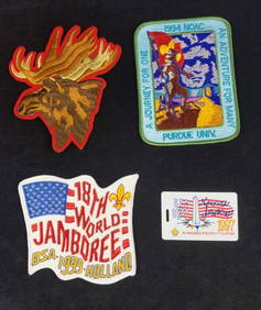
Three Large Boy Scout jamboree Badges And ID CardRapid Estate Liquidators and Auction Gallery4.5(1.1k)See Sold PriceMar 02, 2024