1936 Composite Data Map CT River Basin1936 Composite Data Map of the Connecticut River Drainage Basin, New England Regional Planning Commission, top right corner lost, tear along top edge, minor losses lower right edge, 86" x 35 1/2"See Sold Price
SoldTwo Maps: The Missouri River Basin and MassachusetTwo Maps: The Missouri River Basin and Massachusetts, a "Map to illustrate the route of Prince Maximilian of Wied in the interior of North America From Boston to the Upper Missouri in 1832, 33, & 34,"See Sold Price
1640 Blaeu Map of River Plata Basin to Peru -- Paraguay, o Prov. de Rio de la Plata cum RegionibusTitle: 1640 Blaeu Map of River Plata Basin to Peru -- Paraguay, o Prov. de Rio de la Plata cum Regionibus Adiacentibus Tucuman et Sta. Cruz de la Sierra Cartographer: W Blaeu Year / Place: 1640, AmsteSee Sold Price
Ansel Adams, Moon & Clouds Kern River Basin, 1936Photographer: Ansel Adams (American, 1902 - 1984) - Internationally renowned American photographer. One of the most influential artists in photographic history. Title: Moon & Clouds Kern River Basin DSee Sold Price
Chanlaire/Mentelle: Antique Map of Tagus River valleyTITLE/CONTENT OF MAP: '[Tagus River valley basin in Portugal and Spain]' Central Spain and Portugal. Madrid. Toledo. Lisbon. Tagus River DATE PRINTED: c1810 IMAGE SIZE: Approx 37.5 x 79.0cm, 14.75 x 3See Sold Price
Bellin: Map of Paraguay / Paraná River Basin, 1756Carte du Paraguay et des Pays voisins Bellin's highly detailed and superbly engraved map of the Parana River basin, encompassing modern-day Paraguay and Uruguay and parts of Argentina, Brazil, Chile,See Sold Price
Sold1870 Johnson Maps of Ocean Currents, River Basins andTitle/Content of Map: 1870 Johnson Maps of Ocean Currents, River Basins and Air Temperatures -- Johnson's Ocean Currents and the Great River Basins of the World [on sheet with] Johnson's World ShowingSee Sold Price
Sold1870 Johnson Maps of Ocean Currents, River Basins andTitle: 1870 Johnson Maps of Ocean Currents, River Basins and Air Temperatures -- Johnson's Ocean Currents and the Great River Basins of the World [on sheet with] Johnson's World Showing the DistributiSee Sold Price
SoldSouth America.- Jansson (Jan) Paraguay, o Prov. de RioSouth America.- Jansson (Jan) Paraguay, o Prov. de Rio de la Plata cum Regionibus Adiacentibus Tucuman et Sta. Cruz de la Sierra, map of the Paraguay River basin and the Peru-Chilean coast with Lake TSee Sold Price
Rogue River Drainage Basin Oregon Land Use Map andThis is a Water Resources Dept. land use map of the Rogue River Basin dated 1978. Printed in color by the WRD in 130000 scale. Originally taken in 1974 by U-2 spy plane photos and colorized. Updated iSee Sold Price
SoldWall map of Yolo and American River Basins 1895Heading: (California - Yolo Basin & American Basin) Author: Title: Yolo Basin, Upper Portion [with] Yolo Basin, Lower Portion [with] American Basin Place Published: [Sacramento, Calif.?] Publisher:CaSee Sold Price
Wall map of Yolo and American River Basins 1895Title: Yolo Basin, Upper Portion [with] Yolo Basin, Lower Portion [with] American Basin Author: ** Description: Wall map, with the three maps together, backed with linen, wooden rollers. 140x92 cm. (5See Sold Price
Sold70) THE SIGHT LIGHT CORP. MODERNE FLOOR LAMP W/SW70) THE SIGHT LIGHT CORP. MODERNE FLOOR LAMP W/SWING ARM, PAINT DECORATED, MKD. DEEP RIVER, CT. CANADIAN PATENT 1936, US PAT # 2058139, H. 39 1/2", DIA. TOP 12", DIA. BASE 11"See Sold Price
Arid Regions and Closed River Basins of Asia. Sketch map 1885 old antiqueTITLE/CONTENT OF MAP: 'Arid Regions and Closed Basins of Asia' DATE PRINTED: 1885 IMAGE SIZE: Approx 12.0 x 12.0cm, 4.75 x 4.75 inches (Small) TYPE: Antique engraved sketch map CONDITION: Good; suitabSee Sold Price
SoldSALING (ATTR) (AMERICAN) Farmington River OilPAUL SALING (ATTRIBUTION TO) (AMERICAN (Hartford, CT) 1876-1936), "Farmington River Landscape", oil on board, 12 x 16 in (30.5 x 40.6 cm). This piece comes from a collection of Saling's work.See Sold Price
SoldMaps, San Francisco Bay Area, 1800s(Lot of 16) Assorted San Francisco Bay Area maps, including: ''Sacramento, Eel and Russian River Basins, Water Resources,'' 1960, ''Southern California Electrical Supply,'' 1923, and ''Forest Map of TSee Sold Price
Aral-Caspian Basin old rivers Turkmenistan Uzbekistan Kazakhstan Sketch map 1885TITLE/CONTENT OF MAP: 'Old River Beds of the Aralo-Caspian Basin' DATE PRINTED: 1885 IMAGE SIZE: Approx 10.5 x 11.5cm, 4.25 x 4.5 inches (Small) TYPE: Antique engraved sketch map, scale: 1:13,900,000See Sold Price
Loose brilliant 1.01 ct River(D)/vvs2Loose brilliant 1.01 ct River(D)/vvs2 , proportion middle, symmetry good, polish very good, with DPL-expertiseSee Sold Price
SoldBellin: Plan of Malacca City/Tonkin River Basin ChartMap: Plan de la Ville et Forteresse de Malaca [and on the same sheet] Carte du Cours de la Riviere de Tunquin [Tonkin] Depuis Cacho jusqu'a la Mer Cartographer: Bellin Place & Date: Paris / 1750/1760See Sold Price
SoldRailroad through Yuba River basin.Heading: (California - Yuba River) Author: Barrows, J.W. Title: Project map of portions of Sierra and Placer Counties, focused on the three forks of the Yuba River Place Published: Grass Valley, Cal.See Sold Price
SoldHydro-electric development in Truckee River basinHeading: (California - Lake Tahoe) Author: United States Forest Survey Title: Map of the Drainage Basin of Truckee River, California and Nevada, showing hydro-electric developments Place Published: WaSee Sold Price
Bellin: Paraguay / Paraná River BasinMap Title: Carte du Paraguay et des Pays voisins Cartographer: Bellin Place & Date: Paris / 1756/1760 Size: 12 1/8" x 8 1/8" Condition: b&w; a few light stains; margins extended with contemporary papeSee Sold Price
Partie de la Russie #17 Ural River Russia Kazakhstan. VANDERMAELEN 1827 mapTITLE/CONTENT OF MAP: 'Europe - Partie de la Russie - No 17' The Ural River basin, and the border region between straddling southern Russia and Kazakhstan DATE PRINTED: 1827 IMAGE SIZE: Approx 71.0 xSee Sold Price
Europe. Russie #17 Ural River Southern Russia Kazakhstan. VANDERMAELEN 1827 mapTITLE/CONTENT OF MAP: 'Europe - Partie de la Russie - No 17' The Ural River basin, and the border region between straddling southern Russia and Kazakhstan DATE PRINTED: 1827 IMAGE SIZE: Approx 50.0 xSee Sold Price
Lake Superior and Mississippi River RR 1869 Seven Percent Bonds Book/Report-1869JM Hobby Supply and Railroad Artifact Auctions4.4(126)See Sold PriceFeb 24, 2024
1892 Adams and Bowles New Road Map of the State of New YorkJM Hobby Supply and Railroad Artifact Auctions4.4(126)See Sold PriceFeb 24, 2024
Crams Map of North Dakota-Complete Railroad System and County Map-1907JM Hobby Supply and Railroad Artifact Auctions4.4(126)See Sold PriceFeb 24, 2024
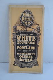
Maine Central RR Through the White Mtns-Portland to the St Lawrence River Book-1901JM Hobby Supply and Railroad Artifact Auctions4.4(126)See Sold PriceFeb 24, 2024
Antique Chinese Hongshan Culture Jade Effigy Carving; Asian; Vintage; Hand-made; The HongshanHeartland Artifact Auctions Inc4.7(780)See Sold PriceMar 10, 2024
Antique Chinese Hongshan Culture Jade Effigy Carving; Asian; Vintage; Hand-made; The HongshanHeartland Artifact Auctions Inc4.7(780)See Sold PriceMar 10, 2024
Antique Chinese Hongshan Culture Jade Effigy Carving; Asian; Vintage; Hand-made; The HongshanHeartland Artifact Auctions Inc4.7(780)See Sold PriceMar 10, 2024
Antique Chinese Hongshan Culture Jade Effigy Carving; Asian; Vintage; Hand-made; The HongshanHeartland Artifact Auctions Inc4.7(780)See Sold PriceMar 10, 2024
Thirty Pieces of Lackawanna Railroad Ephemera - Chief Engineer Timebook, Map, Public Timetables,Rail & Road Auctions4.6(165)See Sold PriceMar 07, 2024
Takahashi (Hiroaki) Shotei, Japanese Woodblock Print, Sumida River in SnowHoch LTD.4.5(73)See Sold PriceFeb 25, 2024
WEST AFRICA Explorers' routes Senegal Ashanti. Mountains of Kong. SDUK 1857 mapJasper524.5(9.8k)See Sold PriceFeb 28, 2024
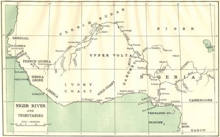
AFRICA. Niger River and Tributaries 1936 old vintage map plan chartJasper524.5(9.8k)See Sold PriceFeb 28, 2024
Goode, George Brown 1884 Lot of 4 Natural History & Meteorology MapsAlbion Auctions4.6(336)See Sold PriceMar 01, 2024
John Senex Map of Louisiana & Mississippi RiverWillow Auction House4.5(283)See Sold PriceMar 14, 2024
A strand of Russian/Eastern European blue glass trade beadsJohn Moran Auctioneers, Inc.4.7(453)See Sold PriceMar 12, 2024