ATLAS of ANTIENT GEOGRAPHY by SAMUEL BUTLER 1843John McInnis Auctioneers,LLC4.5(505)See Sold PriceFeb 24, 2024
18TH C. ANTIQUE MAP: FRENCH & INDIAN WAR, FRAMEDThomaston Place Auction Galleries4.4(393)See Sold PriceFeb 24, 2024
Rand McNally Railroad Map Cabinet w/ 21 Railroad MapsRail & Road Auctions4.6(165)See Sold PriceMar 08, 2024
Keith Haring - Ink on New York Map, Best Buddies, Inscribed, Signed, and DatedSapphire Auction Gallery4(67)See Sold PriceMar 02, 2024
LATE 17TH C. FRENCH MAP OF THE NEW WORLD BY ALEXIS-HUBERT JAILLOT (1632-1712)Thomaston Place Auction Galleries4.4(393)See Sold PriceFeb 24, 2024
Central Railroad of New Jersey Map of Sandy Hook Route-ca. 1903JM Hobby Supply and Railroad Artifact Auctions4.4(127)See Sold PriceFeb 24, 2024
Lot of Six Mixed Atlas Box Cars-HO Scale-New in BoxJM Hobby Supply and Railroad Artifact Auctions4.4(127)See Sold PriceFeb 25, 2024
Rand McNally/Santa Fe Railroad Map of Iowa-1912JM Hobby Supply and Railroad Artifact Auctions4.4(127)See Sold PriceFeb 24, 2024
NICOLAES VISSCHER (NETHERLANDS, 1618-1709) MAP OF THE NEW WORLDThomaston Place Auction Galleries4.4(393)See Sold PriceFeb 24, 2024
17TH C. WORLD MAP BY NICOLAES VISSCHER (NETHERLANDS, 1618-1709)Thomaston Place Auction Galleries4.4(393)See Sold PriceFeb 24, 2024
Lot of Six Mixed Atlas Cabooses-HO Scale-New in BoxJM Hobby Supply and Railroad Artifact Auctions4.4(127)See Sold PriceFeb 25, 2024
Sold1930 Map of the Brookfield Chicago Zoo --Official MapTitle/Content of Map: 1930 Map of the Brookfield Chicago Zoo --Official Map (of) Chicago Zoological Park Brookfield… Date: 1930 ca. Cartographer: Size: 13.3 x18 in. A wonderful folding pictorial mapSee Sold Price
1930 Map of the Brookfield Chicago Zoo --Official MapTitle/Content of Map: 1930 Map of the Brookfield Chicago Zoo --Official Map (of) Chicago Zoological Park Brookfield… Date: 1930 ca. Cartographer: Size: 13.3 x18 in. A wonderful folding pictorialSee Sold Price
1930 Map of the Brookfield Chicago Zoo --Official MapTitle/Content of Map: 1930 Map of the Brookfield Chicago Zoo --Official Map (of) Chicago Zoological Park Brookfield… Date: 1930 ca. Cartographer: Size: 13.3 x18 in. A wonderful folding pictorial mapSee Sold Price
1930 Map of the Brookfield Chicago Zoo --Official MapTitle/Content of Map: 1930 Map of the Brookfield Chicago Zoo --Official Map (of) Chicago Zoological Park Brookfield… Date: 1930 ca. Cartographer: Size: 13.3 x18 in. A wonderful folding pictorial mapSee Sold Price
SoldOfficial map Chicago Zoological Park Brookfield nearTitle/Content of Map: Official map Chicago Zoological Park Brookfield near Riverside Date: 1930 ca. Cartographer: Size: 13.25X18 Color pictorial plan of the zoo grounds. Plan of the Chicago Zoo GroundSee Sold Price
Vintage Map Print - America - Map of The Brookfield Zoo Map Shortly - ChicagoA decorative early map of the Brookfield Zoo. The zoo extends to much the same size that it does today, though it is much less densely built up. The map is designed in an attractive pictorial style, wSee Sold Price
SoldEphemera Road Maps Lot of 4Chicago Motor Club A.A.A. (2) 1924 Chicago and Vicinity, (1) 1930's Chicago and Vicinity, (1) 1933 Official North Central Road MapSee Sold Price
SoldCTA ‘L’ Train Route Map Sign.CTA ‘L’ Train Route Map Sign. [Chicago], 2002. Official CTA hard plastic sign showing the orange, green, red, blue, brown, purple, and yellow lines, with a detail of the Loop. 24 x 18”. Minor suSee Sold Price
SoldOfficial Road Map of Illinois. Chicago: Warner & Beers,Official Road Map of Illinois. Chicago: Warner & Beers, N.d. Plate 11. 25 3/4 x 23 3/4 in. Matted and framed. Property from a Corporate Art CollectionSee Sold Price
12 inches TERRESTRIAL LIBRARY GLOBE LATE 1930 REPLOGLE12 inches TERRESTRIAL LIBRARY GLOBE LATE 1930 REPLOGLE unique base This 12 inches globe was made by the American maker Replogle, one of the Chicago map maker emerging in the early 20th.century . The wSee Sold Price
SoldOfficial Railroad Map of Illinois.Official Railroad Map of Illinois. Chicago: Warner, Higgins, & Beers, (1871). Lithograph outlined in color, plate 11 from the Atlas of White Co. and the State of Illinois. Framed and matted, sight 17See Sold Price
SoldVintage Wolds Fair Pamphlets, Maps and BookletsVintage Wolds Fair Pamphlets, Maps and Booklets spanning the 1930's - 1960's.Includes: Official Detailed Map 1961, Fun at the Fair Money booklet cover, "Man in the 5th Dimesion with Billy Graham PavilSee Sold Price
SoldCHICAGO 1892 OFFICIAL WORLDS FAIR GUIDE MAP ANDChicago 1892 Official World's Fair Guide, Map, and Directory Piece is 7 3/4" x 5 1/4" All items Located in in Hollywood Florida Warehouse For Shipping Call today for quote they have item numbers and PSee Sold Price
SoldRare 1931 Map of Philippine HighwaysHeading: (Philippines - Motor Highways) Author: Title: Philippine Motor Highways Official Road Map, 1931 Place Published: Manila, P.I. Publisher:E .M. Bachrach Date Published: 1930 DesSee Sold Price
Sold(6) ROAD MAPS, NEW YORK, MID-EAST & CHICAGO, VIRGINIAIncludes: (1) Road Map & Historical Guide "New Jersey" - Sunoco, includes NY City, Rand McNally; (1) Official AAA Maps of Main Highways, "….showing Routes to Bear Mountain Bridge", (1) New York CitySee Sold Price
SoldEarly Los Angeles Map Collection [135820]Lot of 11, most different. Included: City & Harbor of Los Angeles, 1921; Special Sightseeing Map of Los Angeles & Vicinity, 1930; Official Transportation and City Map of Los Angeles, Cal and Suburbs,See Sold Price
Official Highway Survey Map of the United StatesTitle: Official Highway Survey Map of the United States Publication Date: 1930 ca. Cartographer: Publisher: NATIONAL MAP COMPANY Size: 42X65 showing Federal, State and Main Connecting Highways in theSee Sold Price
SoldCram's Map of the North Western StatesAnte-Fire Chicago Map 49. [MAP]. CRAM, Geo[rge] F[ranklin]. Cram’s Township & Rail Road Map of the North Western States [upper left] This Map is Engraved from Official Draughts of Each CountSee Sold Price
1930 Map of South CarolinaAuthor: McNally Title: 1930 Map of South Carolina Medium: Ink on Paper Dimensions: 14"X11.5" Description: Map of South Carolina dated 1930. Published in Chicago by the Rand McNally Company. Part of thSee Sold Price
1930 Map of South CarolinaAuthor: McNally Title: 1930 Map of South Carolina Medium: Ink on Paper Dimensions: 14"11.5" Map of South Carolina dated 1930. Published in Chicago by the Rand McNally Company. Part of the World AtlasSee Sold Price
1930 Map of North CarolinaAuthor: Mc Nally Title: 1930 Map of North Carolina Medium: Ink on Paper Dimensions: 14"X11" Map of North Carolina dated 1930. Published in Chicago by the Rand McNally Company. Part of the World AtlasSee Sold Price
SoldRand McNally Map of Indian and Ojlahoma Territories, 1892Rand McNally. Map of the Indian and Oklahoma Territories 1892 Compiled from the Official Records of the General Land Office and Other Sources. Chromolithographed map. Chicago: Rand McNally & Co. Map PSee Sold Price
SoldNew Official Map of the United States, Canada & MexicoRand, McNally & Co. Lithograph with original hand color. Chicago: Rand, McNally & Co., 1891. 32 1/4 x 43 1/4 inches. Rare and very large folding pocket map of the United States with a detailed inset oSee Sold Price
Sold1930 Map of North CarolinaAuthor: McNally Title: 1930 Map of North Carolina Medium: Ink on Paper Dimensions: 14"X11" Description: Map of North Carolina dated 1930. Published in Chicago by the Rand McNally Company. Part of theSee Sold Price
Cincinnati Hamilton and Dayton RR Map -USGC 1889JM Hobby Supply and Railroad Artifact Auctions4.4(127)See Sold PriceFeb 24, 2024
Official Railroad Map of Kansas-1907JM Hobby Supply and Railroad Artifact Auctions4.4(127)See Sold PriceFeb 24, 2024
Rand McNally/Santa Fe Railroad Map of Iowa-1912JM Hobby Supply and Railroad Artifact Auctions4.4(127)See Sold PriceFeb 24, 2024
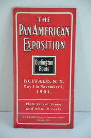
Chicago Burlington and Quincy RR Pan-American Exposition Flyer-1901JM Hobby Supply and Railroad Artifact Auctions4.4(127)See Sold PriceFeb 24, 2024
Chicago Milwaukee and St Paul RY Panama Pacific Exposition Brochure-1915JM Hobby Supply and Railroad Artifact Auctions4.4(127)See Sold PriceFeb 24, 2024
Vintage Full Color World Map LithographThe Benefit Shop Foundation Inc.4.3(2.9k)See Sold PriceFeb 28, 2024
Nova Totius Full Color Geographical World MapThe Benefit Shop Foundation Inc.4.3(2.9k)See Sold PriceFeb 28, 2024
Vintage County Map Of NY State Plate EngravingThe Benefit Shop Foundation Inc.4.3(2.9k)See Sold PriceFeb 28, 2024
Group of New York Central Railroad Paper - Rule Books, Employee Timetables, Stationary, Log Books,Rail & Road Auctions4.6(165)See Sold PriceMar 07, 2024
Pair of Early Railroad Maps - 1862 Pittsburgh, Ft. Wayne & Chicago Railway and 1873 PennsylvaniaRail & Road Auctions4.6(165)See Sold PriceMar 07, 2024
Group of Ten Railroad Photographs, Maps, and Prints - New Jersey, Long Island, and New YorkRail & Road Auctions4.6(165)See Sold PriceMar 07, 2024
Early 1990s Chicago Transit Authority Fiberglass Line MapRail & Road Auctions4.6(165)See Sold PriceMar 08, 2024
Rand McNally Railroad Map Cabinet w/ 21 Railroad MapsRail & Road Auctions4.6(165)See Sold PriceMar 08, 2024
[WORLD WAR II – OKINAWA]. Okinawa Shima Western Beaches Top...Potter & Potter Auctions4.6(545)See Sold PriceMar 07, 2024
[CHICAGO]. Rare Pre-Fire Illinois Map: “Blanchard’s Map of ...Potter & Potter Auctions4.6(545)See Sold PriceMar 07, 2024
Group of 12 Mold-O-Rama Plastic Mold SouvenirsMatthew Bullock Auctioneers4.7(1.8k)See Sold PriceFeb 24, 2024
Vintage 1930 Set of 27 Official Portraits of the Presidents by The Read Printing Company.Westside Traders Emporium4.5(34)See Sold PriceFeb 27, 2024
Herman Moll A New Map of Ye North Parts of AmericaWillow Auction House4.5(289)See Sold PriceMar 14, 2024
Vintage 1920s Rand McNally Auto Trails MapThe Benefit Shop Foundation Inc.4.3(2.9k)See Sold PriceMar 20, 2024


![Early Los Angeles Map Collection [135820] (1 of 1)](https://p1.liveauctioneers.com/2699/211814/108066471_1_x.jpg?height=282&quality=70&version=1626720358)


![[WORLD WAR II – OKINAWA]. Okinawa Shima Western Beaches Top... (1 of 1)](https://p1.liveauctioneers.com/928/318880/171361141_1_x.jpg?height=282&quality=70&version=1707501302)
![[CHICAGO]. Rare Pre-Fire Illinois Map: “Blanchard’s Map of ... (1 of 2)](https://p1.liveauctioneers.com/928/318880/171361260_1_x.jpg?height=282&quality=70&version=1707501302)


