ATLAS of ANTIENT GEOGRAPHY by SAMUEL BUTLER 1843John McInnis Auctioneers,LLC4.6(504)See Sold PriceFeb 24, 2024
18TH C. ANTIQUE MAP: FRENCH & INDIAN WAR, FRAMEDThomaston Place Auction Galleries4.4(389)See Sold PriceFeb 24, 2024
Rand McNally Railroad Map Cabinet w/ 21 Railroad MapsRail & Road Auctions4.6(165)See Sold PriceMar 08, 2024
Keith Haring - Ink on New York Map, Best Buddies, Inscribed, Signed, and DatedSapphire Auction Gallery4.1(67)See Sold PriceMar 02, 2024
LATE 17TH C. FRENCH MAP OF THE NEW WORLD BY ALEXIS-HUBERT JAILLOT (1632-1712)Thomaston Place Auction Galleries4.4(389)See Sold PriceFeb 24, 2024
Central Railroad of New Jersey Map of Sandy Hook Route-ca. 1903JM Hobby Supply and Railroad Artifact Auctions4.4(126)See Sold PriceFeb 24, 2024
Lot of Six Mixed Atlas Box Cars-HO Scale-New in BoxJM Hobby Supply and Railroad Artifact Auctions4.4(126)See Sold PriceFeb 25, 2024
Rand McNally/Santa Fe Railroad Map of Iowa-1912JM Hobby Supply and Railroad Artifact Auctions4.4(126)See Sold PriceFeb 24, 2024
NICOLAES VISSCHER (NETHERLANDS, 1618-1709) MAP OF THE NEW WORLDThomaston Place Auction Galleries4.4(389)See Sold PriceFeb 24, 2024
17TH C. WORLD MAP BY NICOLAES VISSCHER (NETHERLANDS, 1618-1709)Thomaston Place Auction Galleries4.4(389)See Sold PriceFeb 24, 2024
Lot of Six Mixed Atlas Cabooses-HO Scale-New in BoxJM Hobby Supply and Railroad Artifact Auctions4.4(126)See Sold PriceFeb 25, 2024
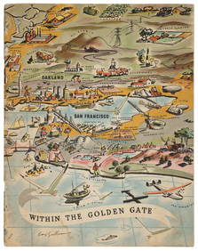
1910 McNally Map of San Francisco and California --Title/Content of Map: 1910 McNally Map of San Francisco and California -- Main portion of San Francisco [verso] California Date: 1910, Chicago Cartographer: Rand, McNally Size: 12.5 x 9.3 in. A very nSee Sold Price
Sold1910 McNally Map of San Francisco and California --Title/Content of Map: 1910 McNally Map of San Francisco and California -- Main portion of San Francisco [verso] California Date: 1910, Chicago Cartographer: Rand, McNallySize: 12.5 x 9.3 in. A very niSee Sold Price
1910 McNally Map of San Francisco and California --Title/Content of Map: 1910 McNally Map of San Francisco and California -- Main portion of San Francisco [verso] California Date: 1910, Chicago Cartographer: Rand, McNally Size: 12.5 x 9.3 in. A very nSee Sold Price
Rand McNally: Antique Map of San Francisco, CaliforniaTitle/Content of Map: 1910 McNally Map of San Francisco and California -- Main portion of San Francisco [verso]California Date Printed: 1910, Chicago Cartographer: Rand, McNally Size: 12.5 9.3 in. A vSee Sold Price
1895 Rand McNally Map of California & San FranciscoTitle/Content of Map: 1895 Rand McNally Map of California and [verso] San Francisco1895, Chicago Cartographer: Rand McNally Size: 11.4 x 9.4 in. An excellent map of California and on reverse, San FranSee Sold Price
1895 Rand McNally Map of California and [verso] SanTitle/Content of Map: 1895 Rand McNally Map of California and [verso] San Francisco -- California [verso] Map of the Main Portion of San Francisco Date: 1895, Chicago Cartographer: Rand McNally Size:See Sold Price
1895 Rand McNally Map of California and San FranciscoTitle/Content of Map: 1895 Rand McNally Map of California and [verso] San Francisco -- California [verso] Map of the Main Portion of San Francisco Date Printed: 1895, Chicago Cartographer: Rand McNallSee Sold Price
SoldMap of California, 1895Original map published from Indexed Atlas of the World by Rand McNally, 1895. Map features insets of San Francisco area & San Diego county. Unframed. Dimensions: 32" L x 25.5" WSee Sold Price
Rare map of LA county 1948Heading: (California - Los Angeles) Author: Title: Rand McNally Map of Los Angeles County: Section of complete map of California Place Published: San Francisco Publisher:Rand McNally and CompanySee Sold Price
Rand, McNally & Co.'S California (And) San FranciscoTitle/Content of Map: Rand, McNally & Co.'S California (And) San Francisco Cartographer: RAND, MCNALLY & CO. Date: 1901 Publisher: RAND, MCNALLY & CO. Size: 26.1Height - 19Width 7+ pages of statisticsSee Sold Price
SoldColor map of San Francisco 1911Heading: (California - San Francisco) Author: Title: Map of San Francisco and Vicinity Place Published: [n.p.] Publisher:Rand McNally & Co. Date Published: 1911 Description:See Sold Price
SoldVintage Pocket Maps (5)Group of five vintage pocket maps by Thomas Bros. and Rand McNally. Includes San Francisco ;California; China and Japan. If lot is absent of a condition report a condition report may be requested viaSee Sold Price
SoldMap of Bay Area ports and facilitiesHeading: (California - San Francisco Bay Area) Author: Rand, McNally & Co. Title: Ports and Facilities on San Francisco Bay, and Tributary Waters Place Published: San Francisco Publisher: Date PuSee Sold Price
Indexed Atlas of the World CaliforniaTitle: Indexed Atlas of the World California Publication Date: 1898 Cartographer: RAND, MCNALLY & CO. Publisher: RAND, MCNALLY & CO. Size: 26 x 19 Map with insets of Vicinity of San Francisco and coasSee Sold Price
Folding map of California & Nevada 1910Heading: (California & Nevada) Author: Weber, C.F. & Co. Title: Webers township and county map of California and Nevada compiled from the latest official data Place Published: San Francisco Publisher:See Sold Price
Folding map of California & Nevada 1910Heading: (California & Nevada) Author: Weber, C.F. & Co. Title: Webers township and county map of California and Nevada compiled from the latest official data Place Published: San Francisco Publisher:See Sold Price
SoldFolding map of California & Nevada 1910Heading: (California & Nevada) Author: Weber, C.F. & Co. Title: Webers township and county map of California and Nevada compiled from the latest official data Place Published: San Francisco Publisher:See Sold Price
SoldMap of California, 1899By Rand, McNally & Co., from Indexed Atlas Of The World. Chicago: 1899. Map features vignettes of Los Angeles, San Bernadino, Orange & San Diego Counties and seperate vignette of San Francisco area. DSee Sold Price
Map of California, 1899By Rand, McNally & Co., from Indexed Atlas Of The World. Chicago: 1899. Map features vignettes of Los Angeles, San Bernadino, Orange & San Diego Counties and seperate vignette of San Francisco area. DSee Sold Price
SoldSan Bruno land development mapHeading: (California - San Bruno) Author: Title: Belle Air Park, San Bruno, San Mateo Country Place Published: San Francisco Publisher:West Shore Realty Co. Date Published: c.1910 DescSee Sold Price
Map of California, 1899By Rand, McNally & Co., from Indexed Atlas Of The World. Chicago: 1899. Map features vignettes of Los Angeles, San Bernadino, Orange & San Diego Counties and seperate vignette of San Francisco area. DSee Sold Price
Subdividing Marin County, c.1910Heading: (California - Marin County) Author: Title: Tamalpais Valley Subdivision No. 1 for sale by Cranston, Belvel & Dwyer Place Published: [San Francisco] Publisher: Date Published: c.1910See Sold Price
SoldSubdividing Marin County, c.1910Heading: (California - Marin County) Author: Title: Tamalpais Valley Subdivision No. 1 for sale by Cranston, Belvel & Dwyer Place Published: [San Francisco] Publisher: Date Published: c.1910See Sold Price
Subdividing Marin County, c.1910Heading: (California - Marin County) Author: Title: Tamalpais Valley Subdivision No. 1 for sale by Cranston, Belvel & Dwyer Place Published: [San Francisco] Publisher: Date Published: c.1910See Sold Price
Chicago Milwaukee and St Paul RY Panama Pacific Exposition Brochure-1915JM Hobby Supply and Railroad Artifact Auctions4.4(126)See Sold PriceFeb 24, 2024
Mixed Group of Railroad Paper, Cross Sections, and Ephemera - Pennsylvania, Reading, Union Pacific,Rail & Road Auctions4.6(165)See Sold PriceMar 07, 2024
Strickler, Rare - San Francisco, CaliforniaTrillium Antique Prints & Rare Books4.5(30)See Sold PriceFeb 24, 2024


![1895 Rand McNally Map of California and [verso] San (1 of 2)](https://p1.liveauctioneers.com/5584/124256/63192766_1_x.jpg?height=282&quality=70&version=1530636078)