Sold18th Century Map of Macao, 1796,by George Nicol, being a map of the city and harbour of Macao, dated April 12th 1796. 86cm x 55cmSee Sold Price
SoldLate 18th Century Map of GeorgiaLate 18th Century Map of GeorgiaGeorgia from the latest Authorities (New York: J. Reid, 1796), copperplate engraving by Benjamin Tanner, no color, presented in mat, unframed. Plate 8.75 x 15.25 in.; SSee Sold Price
Sold18th century map of the United States,[An Accurate Map of the United States of America according to the Treaty of Peace of 1783], engraved by A. Anderson, published by Smith, Reid and Wayland, New York, circa 1796, image 14-1/2 x 18 in.,See Sold Price
SoldThree 18th century maps of KentuckyCyrus Harris, [A Map of the State of Kentucky and the Tennessee Government…], Boston, Thomas & Andrews, 1796, Indian and military boundaries delineated, image 7-3/4 x 11-3/8 in., [extensive foxing aSee Sold Price
SoldLate 18th Century Map of North CarolinaLate 18th Century Map of North CarolinaThe State of North Carolina from the best Authorities from the American Atlas (New York: John Reid, 1796), copperplate engraving by Benjamin Turner with hand-colSee Sold Price
SoldTwo Framed 18th c. Maps Maryland - DelawareTWO framed 18th century maps of Maryland & Delaware 1) Maryland and Delaware together: "J. Denison" c. 1796 at 8" high by 10" wide inside matting.2) "State of Maryland by Samuel Lewis" measuring 11.5"See Sold Price
SoldLate 18th Century American Map of Georgia Extending toLate 18th Century American Map of Georgia Extending to Mississippicopperplate engraving without color, likely published in Philadelphia, between Tennessee's admission to the Union in 1796 and MississiSee Sold Price
SoldTwo 18th Century Georgia MapsAmerican: "A Map of Georgia, also the Two Floridas, from the best Authorities", by Amos Doolittle, published in Jedidiah Morse's [American Universal Geography,] Thomas & Andrews, Boston, 1796, on laidSee Sold Price
Napoleon.- Anonymous (late 18th century) Manuscript mapNapoleon.- Anonymous (late 18th century) Manuscript map illustrating Napoleon's campaign across the Apennines, April 1796, showing the coast from Nice to Savona, part of the Piedmontese Apennine MountSee Sold Price
SoldJOHN REID (AMERICAN, 18TH/19TH CENTURY) MAP OF VIRGINIAJOHN REID (AMERICAN, 18TH/19TH CENTURY) MAP OF VIRGINIA, on laid paper, title in oval cartouche to upper left corner "the STATE of / VIRGINIA / from the best Authorities / 1796", above "Published by JSee Sold Price
SoldVarle Map of Philadelphia, 1796To the Citizens of Philadelphia this Plan of the City and its Environs... Charles P. Varle (18th century), Engraved by Robert Scot. Hand-colored engraving. Philadelphia: Varle, 1796. First State, SnydSee Sold Price
18th century North Carolina map,the State of North Carolina from the best Authorities, engraved by B. Tanner, published in John Reid's [American Atlas,] New York, 1796, engraving on laid paper, 14-1/2 x 19-1/2 in.; modern wood frameSee Sold Price
Sold1796 Geography MAPS English Travel Brookes Gazetteer1796 Geography MAPS English Travel Brookes Gazetteer Civil War Provenance Richard Brookes’ ‘General Gazetteer’ is an 18th-century encyclopedia-like work focusing on geography of the world. OrganSee Sold Price
SoldMap of City and Harbour of MacauA Plan of the City and Harbour of Macao" engraved by B. Baker, Islington 27" x 20 1/2" (sight) hand-colored engraved map 18th century framed- 32 1/2" x 40See Sold Price
Hand colored map, Tennessee,The State of Tennessee, includes Indian territory in central portion of state, probably late 18th century (Tennessee became a state in 1796), 12-3/4 x 21-1/4 in., laid down on 12-3/4 x 24 in. mat boarSee Sold Price
Sold3 Years Travels Through N. America, 179618th century account by Captain Jonathan Carver of the Provincial Troops in America. “Three Years Travels through the Interior Parts of North-America, for more than Five Thousand Miles, containing aSee Sold Price
Two early Tennessee mapsThe State of Tennessee, includes Indian territory in central portion of state, probably late 18th century (Tennessee became a state in 1796), 12-3/4 x 21-1/4 in., laid down on 12-3/4 x 24 in. mat boarSee Sold Price
Sold18th Century Map of the SoutheastLondon, 1747, [A New & Accurate Map of the Provinces of North & South Carolina, Georgia, & C.,] by Emanuel Bowen (1720-1767), noting towns, forts and Indian populations, "Country of the Charokees [sicSee Sold Price
Sold18th Century Map of the Eastern UnitedStates [Virginia Marylandia et Carolina, in America Septentrionali, Brittanorum industria excultae?], by Johann Baptist Homann, originally published in Homann's Atlas Novus, Nuremberg, Germany, 1714,See Sold Price
Sold18th century map of China, Sinarum Regio18th century map of China, Sinarum Regio 20 inches x 23 inchesSee Sold Price
Sold18th century MapAn 18th century Map of the US and Mexico. Hand colored engraving on paper, by Covens & Mortimer, Amsterdam, 1722 entitled "Tabula Geographica Mexicae Et Floridar & C". Some discoloration, center foldSee Sold Price
Sold18th Century Map of Carolina & BermudaMy Herman Moll. Very nicely detailed having some hand tinting. Full margins and not laid down. Good overall condition. Unframed. H7 1/2" W13 1/4"See Sold Price
SoldAn 18th Century Map of the Polish Empire, ExtendingHenri Abraham Chatelain (1684-1743), Paris 1712, title reads 'Carte De Pologne Avec La Chronologie Des Rois Et Des Ducs De Lithuanie, Ainsi Que Des Grands Maitres De L'Ordre Teutonique Les Evechez etSee Sold Price
SoldJefferys' 18th Century Map of Lake ChamplainA Survey of Lake Champlain, including Lake George, Crown Point and St. John... Thomas Jefferys (c. 1719 – 1771). Copperplate engraved map with handcolor in outline. London: Sayer & Bennett, 1776. 21See Sold Price
An early Dutch hand colored engraving map by Georg Balthasar Probst (1732-1801)Ostantix Auctions4.3(9)See Sold PriceFeb 27, 2024
18th Century Hess Germany Hand colored Engraved MapGlobal Auctions Company4.3(36)See Sold PriceMar 03, 2024
18th century MAP of ARMENIA GEORGIA NATOLIA BLACK SEA ASIA MINOR antiqueJasper524.5(9.7k)See Sold PriceFeb 27, 2024
World map.- Macrobius (Ambrosius Aurelius Theodosius) In somnium Scipionis, Libri II. Saturnaliorum,Forum Auctions4.3(52)See Sold PriceFeb 29, 2024
La Basse-Guinée… Loango, Congo, AngoIa & Benguela Southern Africa BONNE 1790 mapJasper524.5(9.7k)See Sold PriceFeb 28, 2024
États du Roi de Maroc… d’Alger, Tunis & Tripoli. North Africa. BONNE 1790 mapJasper524.5(9.7k)See Sold PriceFeb 28, 2024
Le Canal de Mosambique, l'Isle de Madagascar… Mozambique. Africa. BONNE 1788 mapJasper524.5(9.7k)See Sold PriceFeb 28, 2024
Royaumes, Etats et Pays de la Haute Guinée. Gulf of Guinea. BONNE 1788 old mapJasper524.5(9.7k)See Sold PriceFeb 28, 2024
La Nubia ed Abissinia. Red Sea Ethiopia Sudan Eritrea Arabia. ZATTA 1785 mapJasper524.5(9.7k)See Sold PriceFeb 28, 2024
Le Royaume d’Adel… Ajan & Zanguebar. Adal Ajuran. Kenya Tanzania. BONNE 1788 mapJasper524.5(9.7k)See Sold PriceFeb 28, 2024
Le Canal de Mosambique, l'Isle de Madagascar… Mozambique. Africa. BONNE 1790 mapJasper524.5(9.7k)See Sold PriceFeb 28, 2024
Partie Occidentale de l’Afrique. West Africa coast Canary islands BONNE 1788 mapJasper524.5(9.7k)See Sold PriceFeb 28, 2024
Le Royaume d’Adel… Ajan & Zanguebar. Adal Ajuran. Kenya Tanzania. BONNE 1790 mapJasper524.5(9.7k)See Sold PriceFeb 28, 2024
États du Roi de Maroc… d’Alger, Tunis & Tripoli. North Africa. BONNE 1788 mapJasper524.5(9.7k)See Sold PriceFeb 28, 2024
La Basse-Guinée… Loango, Congo, AngoIa & Benguela Southern Africa BONNE 1788 mapJasper524.5(9.7k)See Sold PriceFeb 28, 2024
Egypte, Nubie et Abissinie. Egypt, Nubia & Abyssinia. Sudan. BONNE 1788 mapJasper524.5(9.7k)See Sold PriceFeb 28, 2024
Late 18th century map of England and Wales sampler and two printsFellows4.3(159)See Sold PriceMar 05, 2024
1774: AN ANTIQUE ILLUSTRATED TWO-VOLUME HISTORY OF PERUVIAN DISCOVERY AND CONQUEST WITH MAPNY Elizabeth 4.3(83)See Sold PriceMar 03, 2024
TWO ANTIQUE VOLUMES OF EDWARD GIBSON'S MISCELLANEOUS WORKS IN ENGLISH FROM 1796NY Elizabeth 4.3(83)See Sold PriceMar 03, 2024
MEMORIA TECHNICA, OR, AN INNOVATIVE APPROACH TO MANUFACTURED MEMORY, 1796 WRITTEN BY R. GREYNY Elizabeth 4.3(83)See Sold PriceMar 03, 2024
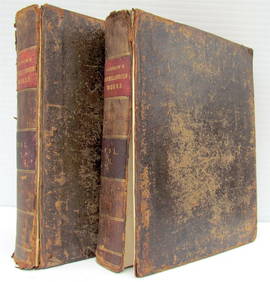
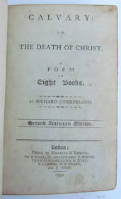
RICHARD CUMBERLANDS, "CAVALARY OR DEATH OF CHRIST," 1796, ANTIQUE AMERICAN POETRYNY Elizabeth 4.3(83)See Sold PriceMar 03, 2024