Sold18th C. Seutter Map of India including SE Asia.Approx 1740. Dimensions: 19.3" h x 23.5" image. Condition: Appears good, age appropriate, not examined outside frame.See Sold Price
Sold19th C. Map of Hindoostan (India) and SE AsiaMap of Hindoostan (India), and SE Asia, 1867, 18" x 26".See Sold Price
SoldSeutter, Hand Colored Map, Asia Minor, 18th C.German, circa 1770. "Natoliae olim Asiae Minoris Tabula per Matth. Seutterum"-circa 1770, hand colored copperplate cartographic engraving by Georg Matthäus Seutter (German, 1678-1757) published in AuSee Sold Price
SoldSeutter, Hand Colored Map, Central Asia, 18th C.German, circa 1770. "Imperi Magni Mogolis sive Indici Padschach"-circa 1740, hand colored copperplate cartographic engraving by Georg Matthäus Seutter (German, 1678-1757) published in Ausburg. A GermSee Sold Price
Sold18TH C BOUND BOOK OF MAPS MOSTLY OF EUROPE, TEXTIN LATIN, 42 PLATES INCLUDING PEROU, ASIA, JUDA, AFRICA, EUROPE, NORWEGE, SUEDE, GUALES, PROVINCES DE FRANCE, BAUIERE, ROYAUME DE BOHEME, WESTPHALIE, HOLLANDOIS, DE L'ITALIE, GRECIA, LES ISLES BRITANNSee Sold Price
SoldEngraved Maps, Lot of 3, 18th c.Lot of 3 engraved maps, including: *** AN ACCURATE MAP OF EUROPE. Emanuel Bowen, ca. 1747. Image 7.75" x 6". Hand-colored. Creasing and soiling. *** AN ACCURATE MAP OF ASIA. [Emanuel Bowen, ca. 1747.]See Sold Price
Sold(3) ANTIQUE MAPS, SPAIN, PORTUGAL, SAXONY, 18TH C.(lot of 3) Antique maps, including: (1) "Saxonie Inferioris Circulus...," c.1730, Georg Matthaus Seutter (German, 1678-1757), hand colored, approx 20.5"h, 23.75"w; (1) "La Catalogna Li Regni Di AragonSee Sold Price
SoldHomann Heirs, Charte van AsienHomann Heirs, Charte van Asien, Homann Heirs (18th c.), "Charte von Asien", c. 1793, hand-colored map of the continent including all of South East Asia and the northern tip of Australia, 20.5"h x 24.5See Sold Price
SoldSeutter, Hand Colored Map, Ottoman Empire, 18th C.German, circa 18th century. "Magni Turcarum Dominatoris Imperium per Europam, Asiam, et Africam se extendens Regiones tam proprias quam tributarias et clientelares ut et omnes Beglerbegatus sive PraefSee Sold Price
SoldGroup Six Framed Maps, 18th/19th CenturyGroup of six framed maps, 18th/19th C., including Chesapeake Bay, Louisiana, West India Isles and others. Framed, not examined out of frames. Sight size: largest 18 1/4" high, 20" wide; smallest: 9" hSee Sold Price
Sold185 19th-20th C. maps: Asia, Pacific, Europe[Asia/Europe]. About 186 Maps, including some 125 maps of countries in Asia and Pacific islands (Turkey, India, China, Japan, Philippines, Guam, and other locales), about 60 maps of Italy, Greece, HunSee Sold Price
SoldSeutter map of Southeast AsiaHeading: Author: Seutter, Matthew Title: India Orientalis cum Adjacentibus Insulis Nova Delineatione ob oculos posita Place Published: Augsburg Publisher: Date Published: [c.1745] DescSee Sold Price
SoldSeutter map of Southeast AsiaHeading: Author: Seutter, Matthew Title: India Orientalis cum Adjacentibus Insulis Nova Delineatione ob oculos posita Place Published: Augsburg Publisher: Date Published: [c.1745] DescSee Sold Price
Sold28 c. 1867 book plate maps28 c. 1867 book plate maps including California; Mexico; Chili; Africa; Brazil; India; Palestine; Asia; Texas. Stains; tears; creases. 15 1/4 inches x 12 1/4 inches.See Sold Price
SoldBleau, Magni Mogolis Imperium, c.mid-1600[India & Asia]. Bleau. Magni Mogolis Imperium. Double-page engraved map of the Mogol Empire between Persia and China, including portions of northern India. c.mid-1600s. 16 1/8 x 20 1/2 inches. Dutch tSee Sold Price
SoldFive Wonderful 18th Century Maps,c.1702-1793, including 'Asien,' by T.Mollo/Schmidt, 'India Orinetalis,' by S.C.M. George August, 'Carte Indes Orientales,' by Charles Henry Friso/Homann Erben and 'Charte von Asien,' by F.L. GuslefeldSee Sold Price
Miniature 19th C. Indo-Persian Paintings (on Camel Bone)Central Asia India/Persia, ca. 18th to 19th century CE. Three Indo-Persian miniature paintings, finely delineated with gouache and/or watercolor on camel bone, including two pendant scenes of a royalSee Sold Price
SoldHERMAN MOLL 18TH C. MAP OF ASIA.Engraved and hand colored “Map of Asia According to the Newest and Most Exact Observations”, London, C 1730: H. Moll (1654-1732), J. Bowles, T. Bowles, P. Overton, and J. King. Two joinedSee Sold Price
SoldGuillaume de L'isle 18th C. Map of Asia, NorthernAuthor: Guillaume de L'isle. Hand Colored Published in 1760 in de I'Isle/Pierre Mortier, Amsterdam "Carte de Tartarie Dressee sur les Relations deSee Sold Price
Soldde LaPorte: Antique Map of India & Southeast Asia, 1787Map: India into SE Asia by De Laporte Date Printed: 1787 Cartographer: Jospeph De Laporte Material/Medium: Paper Size: 9 1/2" x 7 1/2" Condition: Excellent Published in Paris. Copperplate engraved. GeSee Sold Price
2 18th C. European Maps, Bowen & BuchhandlungTwo (2) 18th C. European Maps, including Bowen & Buchhandlung. 1st item: "Plan der Action bey Sandershausen" Map, published by Raspischen Buchhandlung , Nuremberg, circa 1760. Copper plate engraving wSee Sold Price
Sold2 18th C. European Maps, Bowen & BuchhandlungTwo (2) 18th C. European Maps, including Bowen & Buchhandlung. 1st item: "Plan der Action bey Sandershausen" Map, published by Raspischen Buchhandlung , Nuremberg, circa 1760. Copper plate engraving wSee Sold Price
Sold18TH C HANDCOLORED MAP - EUROPA, ASIA & AFRICAMEASURES 20"T X 23"W - CORNER MOUNTED TO CARDBOARDSee Sold Price
EARLY WALL CLOCK WITH "EDMONDS LONDON" FUSEE MOVEMENTThomaston Place Auction Galleries4.4(393)See Sold PriceFeb 24, 2024
EARLY 18TH C. DUTCH CHART OF PACIFIC OCEAN BY FREDERIK DE WIT (1629-1706) WITH CALIFORNIA AS ANThomaston Place Auction Galleries4.4(393)See Sold PriceFeb 24, 2024
EARLY 18TH C. MAP OF ITALY, FRAMEDThomaston Place Auction Galleries4.4(393)See Sold PriceFeb 24, 2024
18TH C. ANTIQUE MAP: FRENCH & INDIAN WAR, FRAMEDThomaston Place Auction Galleries4.4(393)See Sold PriceFeb 24, 2024
EARLY INDIAN WOOD CARVING OF A HINDU DEITYThomaston Place Auction Galleries4.4(393)See Sold PriceFeb 24, 2024
18TH C. CHINESE FAMILLE ROSE PORCELAIN PLATESThomaston Place Auction Galleries4.4(393)See Sold PriceFeb 24, 2024
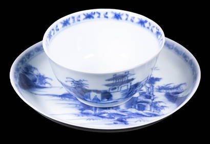
CHINESE NANKING CARGO CUP & SAUCERThomaston Place Auction Galleries4.4(393)See Sold PriceFeb 24, 2024
Two (2) Antique 18th C. Copper Engraved Framed Maps - America & EuropeMagnusson Art Group4.5(53)See Sold PriceMar 14, 2024
Tibetan Gilt Bronze Figure of Avalokiteshvara, Qianlong PeriodLion and Unicorn4.8(1.9k)See Sold PriceMar 12, 2024
18TH C. QUEEN ANNE CHEST ON CHEST, PORTSMOUTH, NH.William Smith Auctions4.6(147)See Sold PriceMar 06, 2024
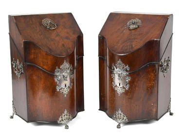
EXCEPTIONAL PR OF 18TH C. GEORGIAN KNIFE BOXES.William Smith Auctions4.6(147)See Sold PriceMar 06, 2024
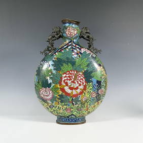
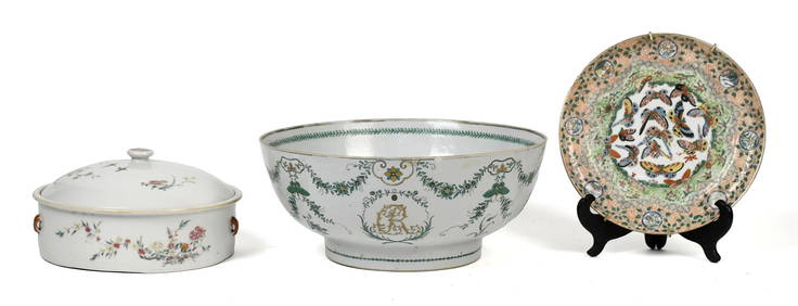
THREE PIECES OF EARLY CHINESE EXPORT PORCELAIN.William Smith Auctions4.6(147)See Sold PriceMar 06, 2024
PR 18TH C. CHINESE CARVED JADE & HARD STONE PANELS.William Smith Auctions4.6(147)See Sold PriceMar 06, 2024
Nepalese Gilt Bronze Figure of Indian Goddess DurgaLion and Unicorn4.8(1.9k)See Sold PriceMar 14, 2024
Near-Miniature 16th C. Thai Bronze Buddha (Lanna)Artemis Fine Arts4.8(1.4k)See Sold PriceFeb 26, 2024