ATLAS of ANTIENT GEOGRAPHY by SAMUEL BUTLER 1843John McInnis Auctioneers,LLC4.5(505)See Sold PriceFeb 24, 2024
18TH C. ANTIQUE MAP: FRENCH & INDIAN WAR, FRAMEDThomaston Place Auction Galleries4.4(393)See Sold PriceFeb 24, 2024
Rand McNally Railroad Map Cabinet w/ 21 Railroad MapsRail & Road Auctions4.6(165)See Sold PriceMar 08, 2024
Keith Haring - Ink on New York Map, Best Buddies, Inscribed, Signed, and DatedSapphire Auction Gallery4.1(67)See Sold PriceMar 02, 2024
LATE 17TH C. FRENCH MAP OF THE NEW WORLD BY ALEXIS-HUBERT JAILLOT (1632-1712)Thomaston Place Auction Galleries4.4(393)See Sold PriceFeb 24, 2024
Central Railroad of New Jersey Map of Sandy Hook Route-ca. 1903JM Hobby Supply and Railroad Artifact Auctions4.4(127)See Sold PriceFeb 24, 2024
Lot of Six Mixed Atlas Box Cars-HO Scale-New in BoxJM Hobby Supply and Railroad Artifact Auctions4.4(127)See Sold PriceFeb 25, 2024
Rand McNally/Santa Fe Railroad Map of Iowa-1912JM Hobby Supply and Railroad Artifact Auctions4.4(127)See Sold PriceFeb 24, 2024
NICOLAES VISSCHER (NETHERLANDS, 1618-1709) MAP OF THE NEW WORLDThomaston Place Auction Galleries4.4(393)See Sold PriceFeb 24, 2024
17TH C. WORLD MAP BY NICOLAES VISSCHER (NETHERLANDS, 1618-1709)Thomaston Place Auction Galleries4.4(393)See Sold PriceFeb 24, 2024
Lot of Six Mixed Atlas Cabooses-HO Scale-New in BoxJM Hobby Supply and Railroad Artifact Auctions4.4(127)See Sold PriceFeb 25, 2024
Sold18TH C. ALEX HOGG WORLD MAPHand colored map " New and Complete Mercator Chart of the World." With publication line. Dimensions: (Frame) H 12.75" x W 16.75" (Sight) H 8" x W 12" Condition: Age toning.See Sold Price
18th Century Engraving "A Man of the Island ofTanna and A Women of Island of Tanna", c.1790, from Ä Collection of Voyages Round The World", London, Alex Hogg,See Sold Price
Sold18th Century Engraving "A Man of the Ifland ofMallicolo and A Women of the Ifland of Mallicolo", c.1794, from Ä Collection of Voyages Round The World", London, Alex Hogg,See Sold Price
Sold18th Century Engraving "A View of Monuments inEaster Island", c.1790, from Ä Collection of Voyages Round The World", London, Alex Hogg, 23.5cm x 38.5cmSee Sold Price
18th Century Engraving "A View in the Island ofTanna" c.1794, from Ä Collection of Voyages Round The World", London, Alex Hogg, 24cm x 38cmSee Sold Price
18th Century Engraving "A Women of Easter Islandand A Man of Easter Island", c.1790, from Ä Collection of Voyages Round The World", London, Alex Hogg, 23cm x 38.5cmSee Sold Price
Sold18th Century Engraving "A Man of the Ifland ofMallicolo and A Women of the Ifland of Mallicolo", c.1794, from Ä Collection of Voyages Round The World", London, Alex Hogg,See Sold Price
Sold18th Century Engraving "A View in the Island ofTanna" c.1794, from Ä Collection of Voyages Round The World", London, Alex Hogg, 24cm x 38cmSee Sold Price
Sold18th Century Engraving "A Women of Easter Islandand A Man of Easter Island", c.1790, from Ä Collection of Voyages Round The World", London, Alex Hogg, 23cm x 38.5cmSee Sold Price
Sold18th Century Engraving "A Man of the Island ofTanna and A Women of Island of Tanna", c.1790, from Ä Collection of Voyages Round The World", London, Alex Hogg,See Sold Price
18th Century Engraving "A View of Monuments inEaster Island", c.1790, from Ä Collection of Voyages Round The World", London, Alex Hogg, 23.5cm x 38.5cmSee Sold Price
SoldHomann Heirs (German, 18th c.) World MapHomann Heirs (German, 18th c.) , "Planiglobii Terrestris Mappa Universalis...", double page, double hemisphere, world map, hand-colored copper engraving, 1746, with four hemispheric projections, two cSee Sold Price
Sold18th C Map Ancient World JerusalemEngraved plate showing maps of ancient world including inset of Judea and Samaria and one of Jerusalem. Early 18th century.Very Good, trimmed to plate lines, measures 7 x 5.5". Reserve: $20.00 ShippinSee Sold Price
Sold18th C. English Map of World18th century English map, depicting the world in the shape of Queen Victoria, 13 1/4" h x 27 1/4" w (view), 20 3/4" h x 15 1/4" w (frame). Provenance: from a Massachusetts estate.See Sold Price
Sold18th c. Map OBSERVATIONS SUR LES POINTS CARDINAUX. LIGNES, ET CIRCLES DE LA SPHÈDescription: 18th c. Hand-colored Engraved Double-page World Map Entitled OBSERVATIONS SUR LES POINTS CARDINAUX. LIGNES, ET CIRCLES DE LA SPHÈRE by Claude Buy de Mornas (17XX-1783), 1761 | One of 1See Sold Price
SoldLATE 18TH C. MAP OF THE WORLD"The World from the Discoveries & Observations made in the Latest Voyages & Travels", 1799, Mercator projection, drawn by Aaron Arrowsmith, engraved by J. Lodge, published by C. Cooke, hand colored enSee Sold Price
SoldFrench 18th C. Map of the WorldGROUP LOT OF 6 MAPS WITH FINE ORIGINAL COLOR Louis Brion de la Tour (c. 1743 – 1803) from Louis C. Desnos' Atlas General Engraved maps with hand color in full Paris, 1779 (1783) each approximately 2See Sold Price
Sold18th c. Map18th c. map of the world marked "A Chart of the World according to Mercators Projection shewing the latest discoveries of Captain Cook", 18th c. printing.See Sold Price
SoldNEEDLE WORK WORLD MAP SAMPLERNEEDLE WORK WORLD MAP SAMPLER, H 18", W 27":Silk on silk embroidery and print on silk. On stretcher, 18" x 25". Printed in ink. Late 18th c.See Sold Price
Sold18th C. Vol., Natural History, Display of Animal18th C. Volume, A New, Complete and Universal body or System of Natural History, Being a Grand and Accurate and extensive display of Animal Nature. Printed for Alex Hogg. Leather bound.See Sold Price
18th C. Vol., Natural History, Display of Animal18th C. Volume, A New, Complete and Universal body or System of Natural History, Being a Grand and Accurate and extensive display of Animal Nature. Printed for Alex Hogg. Leather bound.See Sold Price
Sold18th c. Map DIVERSITÉ DES OMBRES ET DIVERSE SITUATION DES HABITANS DE LA TERRE18th c. Antique French Hand-colored Engraved Double-page World Map Entitled DIVERSITÉ DES OMBRES ET DIVERSE SITUATION DES HABITANS DE LA TERRE by Claude Buy de Mornas (17XX-1783), 1761 | One of 17See Sold Price
SoldWALPOOLE (GEORGE AUGUSTUS) NEW BRITISH TRAVELLER;WALPOOLE (George Augustus) New British Traveller; Or, A Complete Modern Universal Display of Great-Britain and Ireland, London: for Alex Hogg c.1790, folio, plates and maps, full calf (upper board detSee Sold Price
Sold6 Antique 18th C Alexander Hogg English Prints.6 Antique 18thC Alexander Hogg English Prints. Beautifully Framed. Condition: All in Generally Good Condition.Dimensions: Sight-14" x 9". Frame-21" x 16". Provenance: From a Long Island, NY Home. PleaSee Sold Price
17TH C. WORLD MAP BY NICOLAES VISSCHER (NETHERLANDS, 1618-1709)Thomaston Place Auction Galleries4.4(393)See Sold PriceFeb 24, 2024
EARLY 18TH C. DUTCH CHART OF PACIFIC OCEAN BY FREDERIK DE WIT (1629-1706) WITH CALIFORNIA AS ANThomaston Place Auction Galleries4.4(393)See Sold PriceFeb 24, 2024
EARLY 18TH C. MAP OF ITALY, FRAMEDThomaston Place Auction Galleries4.4(393)See Sold PriceFeb 24, 2024
18TH C. ANTIQUE MAP: FRENCH & INDIAN WAR, FRAMEDThomaston Place Auction Galleries4.4(393)See Sold PriceFeb 24, 2024
Set Of 10 18Th C. Sevres Bleu Celeste Cabinet PlatesWorld of Antiques, Inc.3.9(74)See Sold PriceFeb 29, 2024
Two (2) Antique 18th C. Copper Engraved Framed Maps - America & EuropeMagnusson Art Group4.5(53)See Sold PriceMar 14, 2024
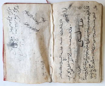
18th C. ARABIC MANUSCRIPT antique ISLAMIC MYSTICAL TREATISE on SPIRITUAL WORLDJasper524.5(9.9k)See Sold PriceFeb 27, 2024
World map.- Macrobius (Ambrosius Aurelius Theodosius) In somnium Scipionis, Libri II. Saturnaliorum,Forum Auctions4.3(53)See Sold PriceFeb 29, 2024
3 Vintage The World Lithographs, By JanssonThe Benefit Shop Foundation Inc.4.3(2.9k)See Sold PriceMar 13, 2024
18th C. Francois N Martinet Colored Engraving of BirdsArtemis Fine Arts4.8(1.4k)See Sold PriceFeb 26, 2024