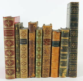
Sold24 misc. Maps on Europe/World. 18th-19th century.[Various] 24 maps. Miscellaneous group of 24 18th-19th century maps depicting Europe and the World. Measurements range from approximately 10” x 7 3/4” to 21 1/4” x 15 5/8”. A fSee Sold Price
SoldAntique Maps(lot of 2) Continental School (18th/19th century), Map of Mediterranean, from "La Geographie Sacree," 1716 and "Planisphere Physique," a map of the Southern Hempishere, engraved by Desbruslins, hand-cSee Sold Price
SoldCOLLECTION OF 18TH AND 19TH CENTURY MAPS.COLLECTION OF 18TH AND 19TH CENTURY MAPS. Comprised of fifteen maps varying from world maps, Asia, Africa, South America, and others. All engravings, some hand colored Largest: 11.5" x 19"See Sold Price
SoldGrp: 6 Maps of Italy 18th-19th c.Group of 18th and 19th century maps of Italy. This group includes one map of Italy, Sardinia, Corsica, and Sicily by Carolo Allard; one map of Sicily by Jan Jansson (1588-1664) with an insert detailinSee Sold Price
SoldGrp: 5 Maps of Sicily Italy 18th/19th c. JaillotGroup of five 18th and 19th century maps of Sicily. Includes Hubert Jaillot , "La Sicile divisee en ses trois Provinces ou Valees, scavoir Valle Demona, Valle Di Noto, et Valle Di Mazara;" and GuillauSee Sold Price
SoldGrp: Assorted Maps of EuropeLarge group of assorted 18th and 19th century maps of Europe. Includes two overall maps of Europe, one map of England and Wales, one map of Scotland, one map of France, one map of Greece, two maps ofSee Sold Price
SoldFIVE 18TH CENTURY MAPS OF THE AMERICASFIVE 18TH CENTURY MAPS OF THE AMERICAS. Comprising five early maps of the Americas including a 1756 Homann Heirs map entitled "America Septentrionalis a Domino D'anville." The map displays color throSee Sold Price
SoldGrp: 54 Maps of the World 18th and 19th c.Group of 54 maps of various regions of the world, dating from the 18th and 19th century. Foldable Map of Navarre on paper attached to linen, Tomás López de Vargas Machuca (1730-1802) "Map of theSee Sold Price
SoldAntique Engraved and Tinted Maplate 18th/early 19th century. Latin map of the Mediterranean by Jannes Jansjonius. framed: H21 1/4" W25 1/2" Private Collection of Dr. Charles Webb, Campobello, South Carolina.See Sold Price
SoldSix 18th and Early 19th Century Nautical Mapsall shrink-wrapped behind mats, titled as follows: Harbour on the Coast of Chili (1770); Port of Permambuco (1816); Chart of New Zealand (1817); Chart of the Intertropical & West Coasts of AustraliaSee Sold Price
Sold18TH CENTURY EDITION SANSON MAP OF THE AMERICAS18TH CENTURY EDITION SANSON MAP OF THE AMERICAS Nicolas Sanson (1600–1667). French cartographer. This hand tinted map engraving is taken from an 18th century atlas after the original 17th century maSee Sold Price
Sold9 Maps: Africa, 1700's - 1800's.[Africa]. 9 Maps. Various sizes, 18th – 19th century. Condition varies, mostly very good, some light toning, foxing, and dampstain. Few with outline color. ++ H. Liebaux. Carte De L’Afrique PropreSee Sold Price
SoldA Group of Antique Prints and Maps18th and 19th centuries, subjects include animals, French maps, architecture, classical and anthropological. Dimensions: From 9 1/2" x 8 1/2" to 14" x 10".See Sold Price
SoldFramed 19th Century Ink on Paper Calligraphic StuFramed 19th Century Ink on Paper Calligraphic Study "Names" and Three Framed 18th/19th Century Needleworks, a silk needlework panel A Map of England & Wales, a sampler, and a "Martha Mcalley, born 177See Sold Price
SoldThirty 18th & 19th Century Leatherbound Books30 total books, poetry and satire, including: 1. Jonathan Swift, MISCELLANIES, Volumes I-XI, London, 1751; brown leather with gilt floral borders, five raised bands, gilt lettering and decoration; 4 1See Sold Price
SoldAN ANTIQUE MAP, "Carte particulière de Isthmus, ouAN ANTIQUE MAP, "Carte particulière de Isthmus, ou Darien, qui comprend le Golfe de Panama & c., Cartegene et les isles aux environs," AMSTERDAM, 18TH/19TH CENTURY, hand colored engraving, a fragSee Sold Price
SoldEarly Map of Georgia, John Payne, Circa 1810John Payne (American, 18th/19th century), "Georgia from the latest Authorities 1810"-1810/11. An early American engraved map of the Southern United States by mapmaker John Payne (American, 18th/19th cSee Sold Price
SoldTobias Conrad Lotter 19th C. Israel Holy Land MapTobias Conrad Lotter (German, 1717-1777). A 19th Century map of the Holy Land in its twelve tribal divisions, based on the work of Lotter, one of the best known 18th century German mapmakers. MeasuresSee Sold Price
Sold1843 Folding Color German World Maps Europe Americas1843 Folding Color German World Maps Europe Americas Geography Austria RARE Three 19th-century world maps published in Vienna in 1843! Published for use in Austrian high schools, this atlas includes fSee Sold Price
SoldLarge New Jersey Archive - 18th and 19th CenturyLarge grouping of New Jersey related land documents, manuscript survey maps, receipts, letters, and miscellaneous documents dating from the early 18th century to the mid 19th century. Family names incSee Sold Price
SoldASSORTED FRENCH MAPS, LOT OF THREEASSORTED FRENCH MAPS, LOT OF THREE, each hand colored, one with page text on verso. Modern frames. 18th and 19th century. Largest 21" x 24" sight. Provenance: Property of a prominent Long Island estatSee Sold Price
SoldFRAMES AND GLAZED EARLY MAP OF SICILY, PROBABLYLATE 18TH, EARLY 19TH CENTURY. BY PHILLIP C LUVERIO. "SICILIAE ANTIQUAE DESCRIPTIO" (OR "THE ANCIENT DESCRIPTION OF SICILY"). INCLUDES THE LATITUDE, LONGITUDE, AND A MAP KEY. SIGHT SIZE 10 1/2" X 12",See Sold Price
SoldColton’s Map of the World - 1855Nice example of Colton's Map of the World from the first edition of Colton’s Atlas of the World. Shows the routes of numerous 18th and 19th Century explorers, including Cook, Furneaux, Vancouver, thSee Sold Price
SoldFIVE MAPS: VIEWS OF DANZIG AND POLAND German andFIVE MAPS: VIEWS OF DANZIG AND POLAND German and England, i.a. Johann Baptist Homann, James Wyld, 18th and 19th century Engraving and lithograph, coloured, on different papers. Visible sitze 50 x 59 cSee Sold Price
A LARGE BLUE AND WHITE 'PLAYING DISCIPLES' BOTTLE VASE, CHINA, 18th - 19th CENTURYGalerie Zacke 4.4(50)See Sold PriceMar 01, 2024
A THANGKA OF CHATURBHUJA AVALOKITESHVARA, TIBET, 18TH - 19TH CENTURYGalerie Zacke 4.4(50)See Sold PriceMar 01, 2024
AN IMPERIAL YELLOW GROUND 'DRAGON' SILK GAUZE PANEL, CHINA, 18TH - 19TH CENTURYGalerie Zacke 4.4(50)See Sold PriceMar 01, 2024
Retablo on Copper, Ecstasy of St. Teresa.Turner Auctions + Appraisals4.3(311)See Sold PriceFeb 24, 2024
The education of the Virgin, 18th - 19th centuriesTemplum Fine Art Auctions4.3(8)See Sold PriceFeb 28, 2024
The education of the Virgin, 18th - 19th centuries, signed Salazar, 20th centuryTemplum Fine Art Auctions4.3(8)See Sold PriceFeb 28, 2024
Spanish colonial tabletop cabinet in mother-of-pearl shell, 18th - 19th centuryTemplum Fine Art Auctions4.3(8)See Sold PriceFeb 28, 2024
Madrid or Mallorcan school from the late 18th - 19th centuries, Still life of fruits and sweetsTemplum Fine Art Auctions4.3(8)See Sold PriceFeb 28, 2024
Chinese 18th & 19th Century Export PorcelainJudd's Auction Gallery, Inc. 4.6(164)See Sold PriceFeb 25, 2024
1758 MAP PARTIE DE LA MER GLACIALE contenants La Nouvelle Zemble RUSSIA antiqueJasper524.5(9.8k)See Sold PriceFeb 27, 2024
18th century MAP of ARMENIA GEORGIA NATOLIA BLACK SEA ASIA MINOR antiqueJasper524.5(9.8k)See Sold PriceFeb 27, 2024
Brass Chart Map Glass Magnifying Desk Lens Magnifier w BoxJasper524.5(9.8k)See Sold PriceFeb 27, 2024
RUSSIAN orthodox icon NECK CROSSES LOT of 10 antique 18th - 19th centuryJasper524.5(9.8k)See Sold PriceFeb 27, 2024
Two Hand-Colored 19th Century Maps of New Orleans and Louisiana, Larger- H.- 12 1/2 in., W.- 15 1/2Crescent City Auction Gallery4.3(229)See Sold PriceMar 08, 2024
Late 18th century map of England and Wales sampler and two printsFellows4.3(159)See Sold PriceMar 05, 2024
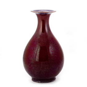
A LARGE CHINESE SANG-DE-BOEUF PEAR-SHAPED VASE, YUHUCHUNPING, 18TH/ 19TH CENTURYElstob Auctioneers4.3(56)See Sold PriceFeb 25, 2024
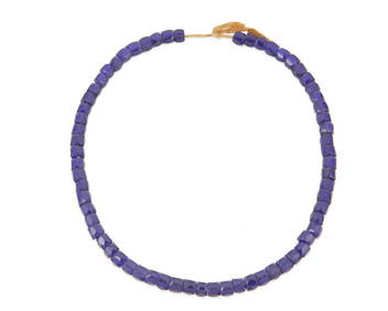
A strand of Russian/Eastern European blue glass trade beadsJohn Moran Auctioneers, Inc.4.7(453)See Sold PriceMar 12, 2024