ATLAS of ANTIENT GEOGRAPHY by SAMUEL BUTLER 1843John McInnis Auctioneers,LLC4.6(502)See Sold PriceFeb 24, 2024
18TH C. ANTIQUE MAP: FRENCH & INDIAN WAR, FRAMEDThomaston Place Auction Galleries4.4(386)See Sold PriceFeb 24, 2024
Rand McNally Railroad Map Cabinet w/ 21 Railroad MapsRail & Road Auctions4.6(165)See Sold PriceMar 08, 2024
Keith Haring - Ink on New York Map, Best Buddies, Inscribed, Signed, and DatedSapphire Auction Gallery4(67)See Sold PriceMar 02, 2024
LATE 17TH C. FRENCH MAP OF THE NEW WORLD BY ALEXIS-HUBERT JAILLOT (1632-1712)Thomaston Place Auction Galleries4.4(386)See Sold PriceFeb 24, 2024
Central Railroad of New Jersey Map of Sandy Hook Route-ca. 1903JM Hobby Supply and Railroad Artifact Auctions4.4(126)See Sold PriceFeb 24, 2024
Lot of Six Mixed Atlas Box Cars-HO Scale-New in BoxJM Hobby Supply and Railroad Artifact Auctions4.4(126)See Sold PriceFeb 25, 2024
Rand McNally/Santa Fe Railroad Map of Iowa-1912JM Hobby Supply and Railroad Artifact Auctions4.4(126)See Sold PriceFeb 24, 2024
NICOLAES VISSCHER (NETHERLANDS, 1618-1709) MAP OF THE NEW WORLDThomaston Place Auction Galleries4.4(386)See Sold PriceFeb 24, 2024
17TH C. WORLD MAP BY NICOLAES VISSCHER (NETHERLANDS, 1618-1709)Thomaston Place Auction Galleries4.4(386)See Sold PriceFeb 24, 2024
Lot of Six Mixed Atlas Cabooses-HO Scale-New in BoxJM Hobby Supply and Railroad Artifact Auctions4.4(126)See Sold PriceFeb 25, 2024
Sold1899 Jones Map U.S. Indian Reservations"Map showing Indian Reservations within the limits of the United States compiled under the direction of the Hon. W. A. Jones Commissioner of Indian Affairs 1899". Includes inset maps of Alaska, CalifoSee Sold Price
Sold1899 W A Jones Map of US Indian Reservations"A Map Showing Indian Resevations Within the Limits of the United States Compiled Under the Direction of the Hon. W. A. Jones Commissioner of Indian Affairs 1899". The Norris Peters Company, WashintonSee Sold Price
Sold1899 Map of Indian Reservations in the US -- MapTitle/Content of Map: 1899 Map of Indian Reservations in the US -- Map Showing Indian Reservations within the Limits of the United States Compiled under the Direction of W. A. Jones Comissioner of IndSee Sold Price
Sold1897 Map of Indian Reservations in the US -- MapReserve Reduced! Title/Content of Map: 1897 Map of Indian Reservations in the US -- Map Showing Indian Reservations within the Limits of the United States Compiled under the Direction of W. A. Jones CSee Sold Price
Sold1896 Map of Indian Reservations in the US -- MapTitle/Content of Map: 1896 Map of Indian Reservations in the US -- Map Showing Indian Reservations within the Limits of the United States Compiled under the Direction of the Hon. D. M. Browning ComissSee Sold Price
Sold1885 Map of Indian Reservations in the US -- MapReserve Reduced! Title/Content of Map: 1885 Map of Indian Reservations in the US -- Map Showing Indian Reservations within the Limits of the United States Compiled under the Direction of the Hon. JohnSee Sold Price
Sold1915 Department of Interior US Indian ReservationsFeatured in this lot is this 1915, Department of Interior U.S. Indian Reservations map. The map shows Indian Reservations as of the year 1915 and shows those areas in orange. The map also shows the DeSee Sold Price
Sold1902 map of Indian ReservationsHeading: (United States - Indian Reservations) Author: Title: Map Showing Indian Reservations Within the Limits of the United States, Compiled Under the Direction of Hon. W.A. Jones, Commissioner ofSee Sold Price
SoldOklahoma, Indian Terr., Indian Res, N.M.T. MapsProposed state of Oklahoma. General Land Office map 1906; Progress of survey and subdivision, Idnian Territory 1896; map showing Indian Reservations within the limits of the US - 1889; and map of theSee Sold Price
SoldMap: Territory of Arizona, 1899Territory of Arizona, 1899, Shows 9 Indian Reservations, Military, much more, good condition & contentSee Sold Price
Gila River Indian Reservation and Casa Grande ValleyPublication Date: 1918 Title: Gila River Indian Reservation and Casa Grande Valley Arizona Cartographer: SAN CARLOS IRRIGATION PROJECT Publisher: U.S. CONGRESS "Compiled from maps furnished by the IndSee Sold Price
Map of Gila River Indian Reservations and CASA GrandeU.S. Bureau of Indian Affairs. Gila River Indian Reservation and CASA Grande Valley, Arizona. Washington, DC. Six mile scaleDimensions: 20" X 35"Note: Map No. 2, San Carlos Irrigation Project; House DSee Sold Price
SoldMap of Gila River Indian Reservations and CASA GrandeU.S. Bureau of Indian Affairs. Gila River Indian Reservation and CASA Grande Valley, Arizona. Washington, DC. Six mile scaleDimensions: 20" X 35"Note: Map No. 2, San Carlos Irrigation Project; House DSee Sold Price
Map of Gila River Indian Reservations and CASA GrandeU.S. Bureau of Indian Affairs. Gila River Indian Reservation and CASA Grande Valley, Arizona. Washington, DC. Six mile scaleDimensions: 20" X 35"Note: Map No. 2, San Carlos Irrigation Project; House DSee Sold Price
Map of Gila River Indian Reservations and CASA GrandeU.S. Bureau of Indian Affairs. Gila River Indian Reservation and CASA Grande Valley, Arizona. Washington, DC. Six mile scaleDimensions: 20" X 35"Note: Map No. 2, San Carlos Irrigation Project; House DSee Sold Price
Map of Gila River Indian Reservations and CASA GrandeU.S. Bureau of Indian Affairs. Gila River Indian Reservation and CASA Grande Valley, Arizona. Washington, DC. Six mile scaleDimensions: 20" X 35"Note: Map No. 2, San Carlos Irrigation Project; House DSee Sold Price
Gila River Indian Reservation and Casa Grande ValleyTitle: Gila River Indian Reservation and Casa Grande Valley Arizona Publication Date: 1918 Cartographer: SAN CARLOS IRRIGATION PROJECT Publisher: U.S. CONGRESS Brief Description: "Compiled from maps fSee Sold Price
Sold1889 Indian Reservation Map of the United StatesThis is a RARE 1889 map of Indian reservations in the United States. With the Indian Removal Act of 1830, the U.S. Government began moving Native American populations to secluded tracts of land. FromSee Sold Price
Sold1891 Indian Reservation Map of the United StatesThis is a RARE 1891 map of Indian reservations in the United States. With the Indian Removal Act of 1830, the U.S. Government began moving Native American populations to secluded tracts of land. FromSee Sold Price
SoldNative American/Western U.S. Expedition Ephemera1st item: "Map Showing the Location of the Indian Reservations Within the Limits of the United States and Territories" compiled from the Official and other Authentic Sources, under the Direction of thSee Sold Price
Sold1921 Department of the Interior Idaho MapThis is an original Department of the Interior map of the State of Idaho. The map shows National Forest land, Indian Reservations, Game Preserves, Military Reservations, National Parks and U.S. ReclamSee Sold Price
SoldU.S. Indian Service Southwestern Badges Ephemerac1900 - Lot of 11. 1) Badge- 1906. Opening of the Shoshone Indian Reservation Lander, WY. 2) Badge- 1904 Opening of the Rosebud Reservation. 3) Badge- 1900, Phoenix, AZ. 4) Badge- 1899, Indian & CSee Sold Price
Sold"Sioux Indian Reservation" ...report... President"Sioux Indian Reservation" - ...report to relate to the proposed division of the great Sioux Reservation and recommending certain legislation. U.S. President Benjamin J. Harrison, 1890, Washington DC:See Sold Price
Cincinnati Hamilton and Dayton RR Map -USGC 1889JM Hobby Supply and Railroad Artifact Auctions4.4(126)See Sold PriceFeb 24, 2024
Rand McNally Railroad Map of Washington-1906JM Hobby Supply and Railroad Artifact Auctions4.4(126)See Sold PriceFeb 24, 2024
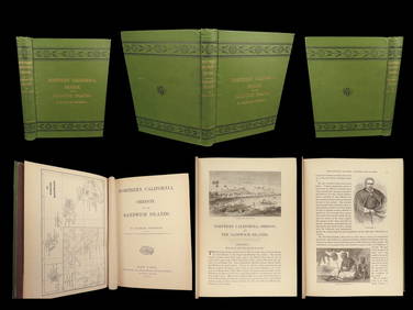
1874 HAWAII 1ed Northern California Oregon Pacific Island Travel Puget RedwoodsSchilb Antiquarian Rare Books4.8(421)See Sold PriceMar 10, 2024
18TH C. ANTIQUE MAP: FRENCH & INDIAN WAR, FRAMEDThomaston Place Auction Galleries4.4(386)See Sold PriceFeb 24, 2024
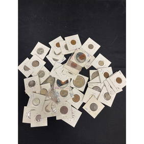
Collection of 61 Foreign and American CoinsPremier Auction Galleries4.3(329)See Sold PriceMar 09, 2024
MATTHEWS c1856 Map Of Upper Canada Ontario Indian Land Agency Divisions Scarce!Luis Porretta Fine Arts4.3(10)See Sold PriceMar 02, 2024
Karl Bodmer - A Young Mandan Indian. 24Trillium Antique Prints & Rare Books4.5(30)See Sold PriceFeb 24, 2024
Karl Bodmer - Assinboin Indians. 32Trillium Antique Prints & Rare Books4.5(30)See Sold PriceFeb 24, 2024
An Indian hardwood and glass elephant form tableAndrew Jones Auctions4.7(206)See Sold PriceFeb 28, 2024
Hist. of Indian wars of the Far West - Massacres of the MountainsJasper524.5(9.8k)See Sold PriceFeb 27, 2024