ATLAS of ANTIENT GEOGRAPHY by SAMUEL BUTLER 1843John McInnis Auctioneers,LLC4.5(505)See Sold PriceFeb 25, 2024
18TH C. ANTIQUE MAP: FRENCH & INDIAN WAR, FRAMEDThomaston Place Auction Galleries4.4(393)See Sold PriceFeb 24, 2024
Rand McNally Railroad Map Cabinet w/ 21 Railroad MapsRail & Road Auctions4.6(165)See Sold PriceMar 08, 2024
Keith Haring - Ink on New York Map, Best Buddies, Inscribed, Signed, and DatedSapphire Auction Gallery4(67)See Sold PriceMar 02, 2024
LATE 17TH C. FRENCH MAP OF THE NEW WORLD BY ALEXIS-HUBERT JAILLOT (1632-1712)Thomaston Place Auction Galleries4.4(393)See Sold PriceFeb 24, 2024
Central Railroad of New Jersey Map of Sandy Hook Route-ca. 1903JM Hobby Supply and Railroad Artifact Auctions4.4(127)See Sold PriceFeb 24, 2024
Lot of Six Mixed Atlas Box Cars-HO Scale-New in BoxJM Hobby Supply and Railroad Artifact Auctions4.4(127)See Sold PriceFeb 25, 2024
Rand McNally/Santa Fe Railroad Map of Iowa-1912JM Hobby Supply and Railroad Artifact Auctions4.4(127)See Sold PriceFeb 24, 2024
NICOLAES VISSCHER (NETHERLANDS, 1618-1709) MAP OF THE NEW WORLDThomaston Place Auction Galleries4.4(393)See Sold PriceFeb 24, 2024
17TH C. WORLD MAP BY NICOLAES VISSCHER (NETHERLANDS, 1618-1709)Thomaston Place Auction Galleries4.4(393)See Sold PriceFeb 24, 2024
Lot of Six Mixed Atlas Cabooses-HO Scale-New in BoxJM Hobby Supply and Railroad Artifact Auctions4.4(127)See Sold PriceFeb 25, 2024
1890 c. Cram Map of Austria-Hungary [verso] Germany --Title: 1890 c. Cram Map of Austria-Hungary [verso] Germany -- Austria [verso] Germany Cartographer: G Cram Year/Place: 1890 c., Chicago Dimensions: 12.5 X 19.8 in. Description: This is a nice map of ASee Sold Price
Sold1883 c. Cram Map of Austria-Hungary -- Austria-HungaryTitle: 1883 c. Cram Map of Austria-Hungary -- Austria-Hungary Cartographer: G Cram Year / Place: 1883 c., Chicago Map Dimension (in.): 8.3 X 11 in. This is a nice map of Austro-Hungarian Empire. It exSee Sold Price
Sold1883 c. Cram Map of Austria-Hungary -- Austria-HungaryTitle/Content of Map: 1883 c. Cram Map of Austria-Hungary -- Austria-Hungary Cartographer: G Cram Year/Place: 1883 c., Chicago Size: 8.3 X 11 in. This is a nice map of Austro-Hungarian Empire. It exisSee Sold Price
1883 c. Cram Map of Austria-Hungary -- Austria-HungaryTitle/Content of Map: 1883 c. Cram Map of Austria-Hungary -- Austria-Hungary Cartographer: G Cram Year/Place: 1883 c., Chicago Size: 8.3 X 11 in. Description: This is a nice map of Austro-Hungarian EmSee Sold Price
189 c. Cram Map of New Hampshire [verso] AdirondacksTitle/Content of Map: 189 c. Cram Map of New Hampshire [verso] Adirondacks and White Mountain -- New Hampshire [verso] Adirondack Mts. and White Mountains Cartographer: G Cram Year/Place: 1890 c., ChiSee Sold Price
189 c. Cram Map of New Hampshire [verso] AdirondacksTitle: 189 c. Cram Map of New Hampshire [verso] Adirondacks and White Mountain -- New Hampshire [verso] Adirondack Mts. and White Mountains Cartographer: G Cram Year / Place: 1890 c., Chicago Map DimeSee Sold Price
SoldWWII Europe escape map: a double sided silk map ( as seWWII Europe escape map: a double sided silk map ( as sewn to the interior of uniform to assist POW escape) of France and verso Germany and Austria including Switzerland, Hungary, Poland etc, with roadSee Sold Price
Sold17th C Fine Engraved Arms of Ferdinand III17th Century beautiful heraldic arms of Ferdinand III of Hungary, Bohemia, Austria, and Germany. Very Good, mounting traces on verso, measures 6.5 x 5.5". Please note that this lot has a confidentialSee Sold Price
Germany (Deutschland) IV Austrian Dominions I Bohemia,Title: Germany (Deutschland) IV Austrian Dominions I Bohemia, Moravia, Austria, Styria, Illyria, Croatia, Sclavonia And Western Hungary. Publication Date: 1852 Cartographer: WALKER, J. & C. LIPSKY/FALSee Sold Price
1910 Rand McNally Map of Austria-Hungary [verso] GermanTitle: 1910 Rand McNally Map of Austria-Hungary [verso] German Empire -- Austria-Hungary [verso] German Empire Cartographer: Rand McNally Year / Place: 1910, Chicago Map Dimension (in.): 9.2 X 13 in.See Sold Price
1910 Rand McNally Map of Austria-Hungary [verso] German Empire -- Austria-Hungary [verso] GermanTitle: 1910 Rand McNally Map of Austria-Hungary [verso] German Empire -- Austria-Hungary [verso] German Empire Cartographer: Rand McNally Year / Place: 1910, Chicago Map Dimension (in.): 9.2 X 13 in.See Sold Price
1890 Cram Map of Louisville verso Indianapolis --Title/Content of Map: 1890 Cram Map of Louisville verso Indianapolis -- Louisville verso Indianapolis Cartographer: G Cram Year/Place: 1890, Chicago Size: 9.6 X 12.8 in. A nice highly detailed map ofSee Sold Price
1890 Cram Map of Cincinnati verso New Orleans --Title/Content of Map: 1890 Cram Map of Cincinnati verso New Orleans -- Cincinnati verso New Orleans Date Printed: 1890, Chicago Cartographer: G Cram Size: 11.4 X 9.4 in. A nice highly detailed map ofSee Sold Price
1890 Cram Map of Louisville verso Indianapolis --Title/Content of Map: 1890 Cram Map of Louisville verso Indianapolis -- Louisville verso Indianapolis Date: 1890, Chicago Cartographer: G Cram Size: 9.6 X 12.8 in. A nice highly detailed map of LouisvSee Sold Price
1890 Cram Map of Louisville verso Indianapolis --Title/Content of Map: 1890 Cram Map of Louisville verso Indianapolis -- Louisville verso Indianapolis Date: 1890, Chicago Cartographer: G Cram Size: 9.6 X 12.8 in. A nice highly detailed map of LouisvSee Sold Price
1890 Cram Map of Louisville verso Indianapolis --Title/Content of Map: 1890 Cram Map of Louisville verso Indianapolis -- Louisville verso Indianapolis Date Printed: 1890, Chicago Cartographer: G Cram Size: 9.6 X 12.8 in. A nice highly detailed map oSee Sold Price
1890 Cram Map of Louisville verso Indianapolis --Reserve Reduced! Title/Content of Map: 1890 Cram Map of Louisville verso Indianapolis -- Louisville verso Indianapolis Date: 1890, Chicago Cartographer: G Cram Size: 9.6 X 12.8 in. A nice highly detaiSee Sold Price
1898 c. Cram Map of Superior WI, verso Omaha and SiouxTitle/Content of Map: 1898 c. Cram Map of Superior WI, verso Omaha and Sioux City -- City of Superior, Wis.; Verso: Omaha; Verso: Official map of Sioux City Date: 1898 c., Chicago Cartographer: G CramSee Sold Price
1898 c. Cram Map of Superior WI, verso Omaha and SiouxTitle/Content of Map: 1898 c. Cram Map of Superior WI, verso Omaha and Sioux City -- City of Superior, Wis.; Verso: Omaha; Verso: Official map of Sioux City Date: 1898 c., Chicago Cartographer: G CramSee Sold Price
1898 c. Cram Map of Superior WI, verso Omaha and SiouxTitle/Content of Map: 1898 c. Cram Map of Superior WI, verso Omaha and Sioux City -- City of Superior, Wis.; Verso: Omaha; Verso: Official map of Sioux City Date: 1898 c., Chicago Cartographer: G CramSee Sold Price
1898 c. Cram Map of Superior WI, verso Omaha and SiouxTitle/Content of Map: 1898 c. Cram Map of Superior WI, verso Omaha and Sioux City -- City of Superior, Wis.; Verso: Omaha; Verso: Official map of Sioux City Date Printed: 1898 c., Chicago CartographerSee Sold Price
1898 c. Cram Map of Superior WI, verso Omaha and SiouxTitle/Content of Map: 1898 c. Cram Map of Superior WI, verso Omaha and Sioux City -- City of Superior, Wis.; Verso: Omaha; Verso: Official map of Sioux City Date: 1898 c., Chicago Cartographer: G CramSee Sold Price
Ludwig Willroider (1845-1910), Bathers at the Lake,Oil on canvas Austria/Germany, c. 1890 Ludwig Willroider (1845-1910) - Austrian landscape painter of the Munich School Signed lower left Lw. Willroider With estate stamp Aus dem Nachlass Ludwig WillroSee Sold Price
Ludwig Willroider (1845-1910), Bathers at the Lake,Oil on canvas Austria/Germany, c. 1890 Ludwig Willroider (1845-1910) - Austrian landscape painter of the Munich School Signed lower left ‘Lw. Willroider’ With estate stamp ‘Aus dem Nachlass LudwSee Sold Price
Crams Township and Railroad Map of New York-1890JM Hobby Supply and Railroad Artifact Auctions4.4(127)See Sold PriceFeb 24, 2024
Wolgemut Nuremburg Chronicle WoodcutSchmidt's Antiques Inc. Since 19114.8(431)See Sold PriceMar 02, 2024
17TH C. WORLD MAP BY NICOLAES VISSCHER (NETHERLANDS, 1618-1709)Thomaston Place Auction Galleries4.4(393)See Sold PriceFeb 24, 2024
LATE 17TH C. FRENCH MAP OF THE NEW WORLD BY ALEXIS-HUBERT JAILLOT (1632-1712)Thomaston Place Auction Galleries4.4(393)See Sold PriceFeb 24, 2024
17TH C. ANTIQUE MAP SIEGE OF LA ROCHELLE, FRANCE, FRAMEDThomaston Place Auction Galleries4.4(393)See Sold PriceFeb 24, 2024
17TH C. MAP OF THE BERKSHIRES BY JOHN SPEED, FRAMEDThomaston Place Auction Galleries4.4(393)See Sold PriceFeb 24, 2024
18TH C. ANTIQUE MAP: FRENCH & INDIAN WAR, FRAMEDThomaston Place Auction Galleries4.4(393)See Sold PriceFeb 24, 2024
Large Collection of Various World Currency - CoinsPremier Auction Galleries4.4(331)See Sold PriceMar 09, 2024
Gunther Gumpert O/C Impasto Abstract PaintingHeritage Gallery Auctions4.4(60)See Sold PriceMar 10, 2024
Victor Vasarely (Hungarian/French, 1906-1997) - Composition Carrée ReliefFreeman's | Hindman4.5(158)See Sold PriceFeb 28, 2024
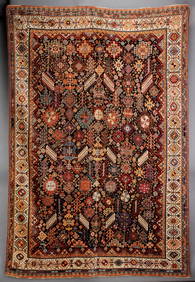
A FINE ANTIQUE SOUTHWEST PERSIAN QASHQUAI RUG C. 1890Soulis Auctions4.8(953)See Sold PriceFeb 24, 2024
American Eastlake Carved Walnut Overmantel Mirror, c. 1890, the roundel mounted crest over an archedCrescent City Auction Gallery4.3(231)See Sold PriceMar 01, 2024
Willem Blaeu, Etc. 17th C. Antiquarian Maps, 2Auctions at Showplace4.6(740)See Sold PriceMar 17, 2024
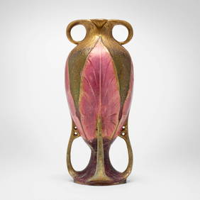
Riessner, Stellmacher & Kessel, Tall Amphora vaseToomey & Co. Auctioneers4.7(392)See Sold PriceFeb 29, 2024
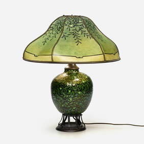
Max Laeuger, Table lamp base with mistletoeToomey & Co. Auctioneers4.7(392)See Sold PriceFeb 29, 2024
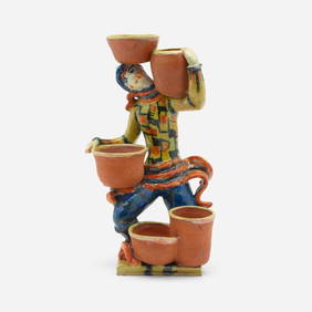
Gudrun Baudisch, Wiener Werkstatte, KakteentragerToomey & Co. Auctioneers4.7(392)See Sold PriceFeb 29, 2024
Wiener Werkstatte, Collection of accessoriesToomey & Co. Auctioneers4.7(392)See Sold PriceFeb 29, 2024
![1890 c. Cram Map of Austria-Hungary [verso] Germany -- First Image](https://p1.liveauctioneers.com/5584/204143/103498455_1_x.jpg?height=282&quality=95&version=1621369270&width=282)

![1890 c. Cram Map of Austria-Hungary [verso] Germany -- First Image](https://p1.liveauctioneers.com/5584/204143/103498455_1_x.jpg?height=282&quality=1&version=1621369270&width=282)


![1890 c. Cram Map of Austria-Hungary [verso] Germany -- (1 of 2)](https://p1.liveauctioneers.com/5584/189023/95114460_1_x.jpg?height=282&quality=70&version=1608680643)


![189 c. Cram Map of New Hampshire [verso] Adirondacks (1 of 2)](https://p1.liveauctioneers.com/5584/175972/88577587_1_x.jpg?height=282&quality=70&version=1597183226)
![189 c. Cram Map of New Hampshire [verso] Adirondacks (1 of 2)](https://p1.liveauctioneers.com/5584/211521/107852933_1_x.jpg?height=282&quality=70&version=1626815225)


![1910 Rand McNally Map of Austria-Hungary [verso] German (1 of 2)](https://p1.liveauctioneers.com/5584/192977/97276908_1_x.jpg?height=282&quality=70&version=1612304273)
![1910 Rand McNally Map of Austria-Hungary [verso] German Empire -- Austria-Hungary [verso] German (1 of 2)](https://p1.liveauctioneers.com/5584/267896/140124820_1_x.jpg?height=282&quality=70&version=1668549165)