ATLAS of ANTIENT GEOGRAPHY by SAMUEL BUTLER 1843John McInnis Auctioneers,LLC4.6(502)See Sold PriceFeb 24, 2024
18TH C. ANTIQUE MAP: FRENCH & INDIAN WAR, FRAMEDThomaston Place Auction Galleries4.4(386)See Sold PriceFeb 24, 2024
Rand McNally Railroad Map Cabinet w/ 21 Railroad MapsRail & Road Auctions4.6(165)See Sold PriceMar 08, 2024
Keith Haring - Ink on New York Map, Best Buddies, Inscribed, Signed, and DatedSapphire Auction Gallery4(67)See Sold PriceMar 02, 2024
LATE 17TH C. FRENCH MAP OF THE NEW WORLD BY ALEXIS-HUBERT JAILLOT (1632-1712)Thomaston Place Auction Galleries4.4(386)See Sold PriceFeb 24, 2024
Central Railroad of New Jersey Map of Sandy Hook Route-ca. 1903JM Hobby Supply and Railroad Artifact Auctions4.4(126)See Sold PriceFeb 24, 2024
Lot of Six Mixed Atlas Box Cars-HO Scale-New in BoxJM Hobby Supply and Railroad Artifact Auctions4.4(126)See Sold PriceFeb 25, 2024
Rand McNally/Santa Fe Railroad Map of Iowa-1912JM Hobby Supply and Railroad Artifact Auctions4.4(126)See Sold PriceFeb 24, 2024
NICOLAES VISSCHER (NETHERLANDS, 1618-1709) MAP OF THE NEW WORLDThomaston Place Auction Galleries4.4(386)See Sold PriceFeb 24, 2024
17TH C. WORLD MAP BY NICOLAES VISSCHER (NETHERLANDS, 1618-1709)Thomaston Place Auction Galleries4.4(386)See Sold PriceFeb 24, 2024
Lot of Six Mixed Atlas Cabooses-HO Scale-New in BoxJM Hobby Supply and Railroad Artifact Auctions4.4(126)See Sold PriceFeb 25, 2024
1889 Map of Washington TerritoryTitle: 1889 Map of Washington Territory Medium: Ink on Paper Dimensions: 14.5"X11" Description: Map of Washington state dated 1889. Engraved and published by Watson in Chicago. Map was published rightSee Sold Price
A report on Washington Territory, 1889 BookPublished by Seattle, Lake Shore & Eastern Railway. 6-1/2" x 9" hard cover with 242 pages. 10 illustrations and five maps, including two folding maps in the rear pocket.See Sold Price
SoldU.S. MAP WASHINGTON TERRITORY, ANSON HENRY, 1863"Map of Public Surveys, Washington Territory to accompany Report of Surv: Genl: 1863, Anson G. Henry, Surveyor General, Lith of J. Bien 24 Vesey St, NY", showing positions of Mt. Baker, Gold Mines, OlSee Sold Price
Cram's Washington (territory) MapCram's Washington (territory) Map, Washington (Territory) George F. Cram 1887 Map, 13.5 x 11 in Please note that this lot has a confidential reserve. When you leave a bid in advance of the auction, suSee Sold Price
NORTHERN PACIFIC AND PUGET SOUND SHORE RR CO1889. Washington Territory. Stock certificate1 share. Black/white. Litho. Star punch cancelled and Excellent.See Sold Price
NORTHERN PACIFIC AND PUGET SOUND SHORE RAILROAD CO1889. Washington Territory. Stock certificate1 share. Black/white. Litho. Star punch cancelled and Excellent.See Sold Price
NORTHERN PACIFIC & PUGET SOUND SHORE RAILROAD CO.1889. Washington Territory. Stock certificate1 share. Black/white. Litho. Star punch cancelled and Excellent.See Sold Price
Stock I/S To Samuel Wilkeson Jr.,1889, Washington Territory. Spokane & Palouse Railway Co Stock certificate for 1 Share. Black. Issued to S. Wilkeson, Jr. and signed by him on verso. Samuel Wilkeson Jr., took interest in the transconSee Sold Price
SoldCENTRAL WASHINGTON RAILROAD COMPANY1889, Washington Territory. Stock certificate for 1 share. Black. Blind embossed company seal. Punch cancelled. Very Fine. This item is encapsulated and accompanied by a PASS-CO Securities Pass.See Sold Price
SoldCASCADE MOUNTAIN COAL COMPANY1889, Washington Territory. Stock certificate for one share. Black/White. Litho. Crayon and star punch cancellations.See Sold Price
SoldThe Queen City Railway Co (of Seattle) (103238)Incorporates 1889 Washington Territory. #1, I.U, $1000, 1st Mortgage Sinking Fund 30 Year 5% Issued Gold Bearer Bond, issued July 1. 1889, signed Wm.Giliet President. GREEN, embossed gold corp. seal.See Sold Price
SoldThe Queen City Railway Co (of Seattle) (103239)Incorporates 1889 Washington Territory. #110 I.U, $1000, 1st Mortgage Sinking Fund 30 Year 5% Issued Gold Bearer Bond, issued July 1. 1889, signed Wm.Giliet President. GREEN, embossed gold corp. seal.See Sold Price
Central Washington Railroad Company1889, Washington Territory. Stock certificate for 1 share. Black. Lightly punch cancelled and Very Fine.See Sold Price
NORTHERN PACIFIC & PUGET SOUND SHORE RAILROAD CO.1889. Washington Territory. Stock certificate1 share. Black/white. Litho. Star punch cancelled and Excellent.See Sold Price
NORTHERN PACIFIC AND PUGET SOUND SHORE RAILROAD CO1889. Washington Territory. Stock certificate1 share. Black/white. Litho. Star punch cancelled and Excellent.See Sold Price
SoldWhite, Charles A, Map of Washington Territory West ofWhite, Charles A, Map of Washington Territory West of the Cascade Mountains. New York: G.W. & C.B. Colton & Co., 1870. Lithographed map on four sheets, 123 x 167 cm, hand-colored. (Some creasing.) OriSee Sold Price
SoldMap of Washington Territory west of Cascade Mountains,Map of Washington Territory west of Cascade Mountains, comp. by Charles A. White. NY: 1870Statue miles 4 to One (1) inch.Dimensions: 30 1/2" X 20 1/2" and 30 1/4" X 15" in Two (2) sections (maps)Inv.3See Sold Price
SoldGLO Map of Washington Territory, ca 1860-61**Originally Listed At $100** Map of a Part of Washington Territory to Accompany the Report of the Surveyor General 1860-61. A very collectible early survey map of the Washington Territory that was coSee Sold Price
SoldMap of Washington Territory, 1859Map: 1859 Washington Territory Map -- Map of a Part of Washington Territory to Accompany the report of the Surveyor General Cartographer: US State Surveys (J Tilton) Year / Place: 1859 Washington MapSee Sold Price
SoldPocket map of Washington Territory 1878Heading: Author: Habersham, Robert A. Title: J.K. Gill & Cos. Map of Washington Ter. Portland Ogn. 1878. Showing all surveys made previous to January 1st 1878. Compiled by Robt. A. Habersham Civil EnSee Sold Price
SoldMap of Washington Territory 1879Title: Washington Territory Author: U.S. State Surveys Description: Color lithographed map. Compiled by C. Roeser from the official records of the General Land Office. Lithographed by Julius Bien. 56xSee Sold Price
1883 Map of Washington TerritoryAuthor: Cram Title: 1883 Map of Washington Territory Medium: Ink on Paper Dimensions: 13.5"X11" Map of Washington territory dated 1883. Engraved and published by George Cram in Chicago. Color coded foSee Sold Price
1889 Map of Washington StateAuthor: Watson Title: 1889 Map of Washington State Medium: Ink on Paper Dimensions: 14.5"X11" Map of Washington state dated 1889. Engraved and published by Watson in Chicago. Map was published right aSee Sold Price
GLO Map of Washington Territory, ca 1860-61**Originally Listed At $100** Map of a Part of Washington Territory to Accompany the Report of the Surveyor General 1860-61. A very collectible early survey map of the Washington Territory that was coSee Sold Price
Cincinnati Hamilton and Dayton RR Map -USGC 1889JM Hobby Supply and Railroad Artifact Auctions4.4(126)See Sold PriceFeb 24, 2024
Northern Pacific RR Washington and Northern Idaho Map Folder-1941JM Hobby Supply and Railroad Artifact Auctions4.4(126)See Sold PriceFeb 24, 2024
Rand McNally Railroad Map of Washington-1906JM Hobby Supply and Railroad Artifact Auctions4.4(126)See Sold PriceFeb 24, 2024
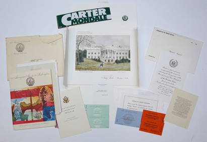
1977 INAUGURATION of PRESIDENT JIMMY CARTERJohn McInnis Auctioneers,LLC4.6(502)See Sold PriceFeb 25, 2024
Mitchell - Map of the City of Washington (Washington, DC)Trillium Antique Prints & Rare Books4.5(30)See Sold PriceFeb 24, 2024
North & West Africa. Dahomey. Gold Coast. Military Territory. THE TIMES 1922 mapJasper524.5(9.8k)See Sold PriceFeb 28, 2024
CENTRAL AFRICA. International African Association (Congo) Gabon Angola 1889 mapJasper524.5(9.8k)See Sold PriceFeb 28, 2024
Two Hand-Colored 19th Century Maps of New Orleans and Louisiana, Larger- H.- 12 1/2 in., W.- 15 1/2Crescent City Auction Gallery4.3(229)See Sold PriceMar 08, 2024
Goode, George Brown 1884 Lot of 4 Natural History & Meteorology MapsAlbion Auctions4.6(336)See Sold PriceMar 01, 2024
Perry, Matthew C. 1856 Large Map. Shah Bay, Lew Chew I. JapanAlbion Auctions4.6(336)See Sold PriceMar 01, 2024
Francis McNally - Antique Map of Washington, Oregon, Idaho, Nevada, Utah & ArizonaProverde Auctions4.3(3)See Sold PriceFeb 28, 2024
Robert H Labberton - Map of The Territory of the Present United States - The territory of theProverde Auctions4.3(3)See Sold PriceFeb 28, 2024
[Spokane, Washington State] Maps, Pins & More (8)Grant Zahajko Auctions, LLC4.8(1k)See Sold PriceMar 06, 2024
C.1888 Tacoma Boudoir Card Waterfront by RutterGrant Zahajko Auctions, LLC4.8(1k)See Sold PriceMar 06, 2024
[Washington Territory, Lumber] Letterhead (7)Grant Zahajko Auctions, LLC4.8(1k)See Sold PriceMar 06, 2024
The Kingdom of Dalmatia Territories Map, 1700Antiques Online Auctions4.6(407)See Sold PriceMar 14, 2024
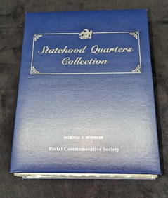
Statehood Quarters Collection Postal Commemorative Society Volume 2Rapid Estate Liquidators and Auction Gallery4.5(1.1k)See Sold PriceMar 03, 2024


![[Spokane, Washington State] Maps, Pins & More (8) (1 of 5)](https://p1.liveauctioneers.com/5755/320282/172114031_1_x.jpg?height=282&quality=70&version=1708463029)

![[Washington Territory, Lumber] Letterhead (7) (1 of 5)](https://p1.liveauctioneers.com/5755/320282/172114106_1_x.jpg?height=282&quality=70&version=1708463029)