ATLAS of ANTIENT GEOGRAPHY by SAMUEL BUTLER 1843John McInnis Auctioneers,LLC4.5(505)See Sold PriceFeb 24, 2024
18TH C. ANTIQUE MAP: FRENCH & INDIAN WAR, FRAMEDThomaston Place Auction Galleries4.4(393)See Sold PriceFeb 24, 2024
Rand McNally Railroad Map Cabinet w/ 21 Railroad MapsRail & Road Auctions4.6(165)See Sold PriceMar 08, 2024
Keith Haring - Ink on New York Map, Best Buddies, Inscribed, Signed, and DatedSapphire Auction Gallery4(67)See Sold PriceMar 02, 2024
LATE 17TH C. FRENCH MAP OF THE NEW WORLD BY ALEXIS-HUBERT JAILLOT (1632-1712)Thomaston Place Auction Galleries4.4(393)See Sold PriceFeb 24, 2024
Central Railroad of New Jersey Map of Sandy Hook Route-ca. 1903JM Hobby Supply and Railroad Artifact Auctions4.4(127)See Sold PriceFeb 24, 2024
Lot of Six Mixed Atlas Box Cars-HO Scale-New in BoxJM Hobby Supply and Railroad Artifact Auctions4.4(127)See Sold PriceFeb 25, 2024
Rand McNally/Santa Fe Railroad Map of Iowa-1912JM Hobby Supply and Railroad Artifact Auctions4.4(127)See Sold PriceFeb 24, 2024
NICOLAES VISSCHER (NETHERLANDS, 1618-1709) MAP OF THE NEW WORLDThomaston Place Auction Galleries4.4(393)See Sold PriceFeb 24, 2024
17TH C. WORLD MAP BY NICOLAES VISSCHER (NETHERLANDS, 1618-1709)Thomaston Place Auction Galleries4.4(393)See Sold PriceFeb 24, 2024
Lot of Six Mixed Atlas Cabooses-HO Scale-New in BoxJM Hobby Supply and Railroad Artifact Auctions4.4(127)See Sold PriceFeb 25, 2024
1887 Warren Map of Northwest Midwest States -- Map ofTitle/Content of Map: 1887 Warren Map of Northwest Midwest States -- Map of the Central States West of the Mississippi River Date: 1887, Philadelphia Cartographer: D Warren Size: 10.6 X 8.8 in. This iSee Sold Price
1887 Warren Map of Central States -- Map of Nine of theTitle/Content of Map: 1887 Warren Map of Central States -- Map of Nine of the Central States Date: 1887, Philadelphia Cartographer: D Warren Size: 10.6 X 8.8 in. This is a nice map of the central statSee Sold Price
1887 Warren Map of Central States East of MissisippiTitle/Content of Map: 1887 Warren Map of Central States East of Missisippi River -- Map of the Central States East of the Mississippi River Date: 1887, Philadelphia Cartographer: D Warren Size: 10.6 XSee Sold Price
Sold1887 United States Map Puzzle McLoughlin BrothersA New Dissected Map Of The United States Puzzle. McLoughlin Bros. New York. Copyright 1887. 12 1/4" X 8 1/4" Missing Pieces.See Sold Price
Sold1887 Mitchell Map of the United States -- Map of theTitle/Content of Map: 1887 Mitchell Map of the United States -- Map of the United States, and Territories. Together with Canada &c Date: 1887, Philadelphia Cartographer: S Mitchell Size: 13.2 x 21.5 iSee Sold Price
Northwest United States Maps (120885)Four maps of the northwestern United States, including Montana and Washington. Maps measure 26"x 40", 30"x 40", 22"x 30" and 23"x 28". They were used for logging purposes. They appear to be in good coSee Sold Price
Northwest United States Maps (120885)Four maps of the northwestern United States, including Montana and Washington. Maps measure 26"x 40", 30"x 40", 22"x 30" and 23"x 28". They were used for logging purposes. They appear to be in good coSee Sold Price
1852 Mitchell Map of Midwest United States and KentuckyTitle/Content of Map: 1852 Mitchell Map of Midwest United States and Kentucky -- No. 14 Map of the Chief Part of the Western States including Western Virginia Date Printed: 1852 Philadelphia CartograpSee Sold Price
1852 Mitchell Map of Midwest United States and KentuckyTitle/Content of Map: 1852 Mitchell Map of Midwest United States and Kentucky -- No. 14 Map of the Chief Part of the Western States including Western Virginia Date Printed: 1852 Philadelphia CartograpSee Sold Price
Mitchell: Antique Map of Midwest United States, 1852Title/Content of Map: 1852 Mitchell Map of Midwest United States and Kentucky -- No. 14 Map of the Chief Part of the Western States including Western Virginia Date Printed: 1852 Philadelphia CartograpSee Sold Price
1852 Mitchell Map of Midwest United States and KentuckyTitle/Content of Map: 1852 Mitchell Map of Midwest United States and Kentucky -- No. 14 Map of the Chief Part of the Western States including Western Virginia Date: 1852 Philadelphia Cartographer: S MSee Sold Price
1852 Mitchell Map of Midwest United States and KentuckyReserve Reduced! Title/Content of Map: 1852 Mitchell Map of Midwest United States and Kentucky -- No. 14 Map of the Chief Part of the Western States including Western Virginia Date: 1852 PhiladelphiaSee Sold Price
1852 Mitchell Map of Midwest United States and KentuckyTitle: 1852 Mitchell Map of Midwest United States and Kentucky -- No. 14 Map of the Chief Part of the Western States including Western Virginia Date: 1852 Philadelphia Cartographer: S Mitchell / CowpeSee Sold Price
1852 Mitchell Map of Midwest United States and KentuckyTitle: 1852 Mitchell Map of Midwest United States and Kentucky -- No. 14 Map of the Chief Part of the Western States including Western Virginia Cartographer: S Mitchell / Cowperthwait & Co. Year / PlaSee Sold Price
1852 Mitchell Map of Midwest United States and KentuckyTitle/Content of Map: 1852 Mitchell Map of Midwest United States and Kentucky -- No. 14 Map of the Chief Part of the Western States including Western Virginia Cartographer: S Mitchell / Cowperthwait &See Sold Price
1852 Mitchell Map of Midwest United States andTitle/Content of Map: 1852 Mitchell Map of Midwest United States and Kentucky-- No. 14 Map of the Chief Part of the Western States including Western Virginia Date: 1852 Philadelphia Cartographer: S MiSee Sold Price
Warner Beers: Map of Mid Atlantic, Midwest, 1875Map: 1875 Warner Beers Map of Mid Atlantic and Midwest United States -- County Map of New York, New Jersey, Pennsylvinia, Ohio, Deleware, Maryland, Virginia, West Virginia Cartographer: Warner Beers YSee Sold Price
SoldBeers: Antique Map of Mid Atlantic Midwest US, 1875Title: 1875 Warner Beers Map of Mid Atlantic and Midwest United States -- County Map of New York, New Jersey, Pennsylvinia, Ohio, Deleware, Maryland, Virginia, West Virginia Cartographer: Warner BeersSee Sold Price
1875 Warner Beers MidAtlantic/Midwest United States Map1875 Warner Beers Map of Mid Atlantic and Midwest United States -- County Map of New York, New Jersey, Pennsylvinia, Ohio, Deleware, Maryland, Virginia, West Virginia Warner Beers 1875 Chicago 17 X 14See Sold Price
Sold1887 Mitchell Railroad Map of the United States --Title: 1887 Mitchell Railroad Map of the United States -- Railroad Map of the United States, Showing the through Lines of Communication from the Atlantic to the Pacific. Together with the Various SteaSee Sold Price
1887 Mitchell Railroad Map of the United States --Title: 1887 Mitchell Railroad Map of the United States -- Railroad Map of the United States, Showing the through Lines of Communication from the Atlantic to the Pacific. Together with the Various SteaSee Sold Price
1887 Mitchell Railroad Map of the United States --Title/Content of Map: 1887 Mitchell Railroad Map of the United States -- Railroad Map of the United States, Showing the through Lines of Communication from the Atlantic to the Pacific. Together with tSee Sold Price
1892 Adams and Bowles New Road Map of the State of New YorkJM Hobby Supply and Railroad Artifact Auctions4.4(127)See Sold PriceFeb 24, 2024
American Express/New York Central Railroad Map of the United States-1934JM Hobby Supply and Railroad Artifact Auctions4.4(127)See Sold PriceFeb 24, 2024
Crams Railroad Map of New York-1881JM Hobby Supply and Railroad Artifact Auctions4.4(127)See Sold PriceFeb 24, 2024
Crams Township and Railroad Map of New York-1890JM Hobby Supply and Railroad Artifact Auctions4.4(127)See Sold PriceFeb 24, 2024
Crams Township and Railroad Map of Pennsylvania-1898JM Hobby Supply and Railroad Artifact Auctions4.4(127)See Sold PriceFeb 24, 2024
Rand McNally Railroad Map of Washington-1906JM Hobby Supply and Railroad Artifact Auctions4.4(127)See Sold PriceFeb 24, 2024
Union Pacific RR Map of the United States-1926JM Hobby Supply and Railroad Artifact Auctions4.4(127)See Sold PriceFeb 24, 2024
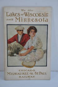
Chicago Milwaukee and St Paul RY To the Lakes of Wisconsin and Minnesota Book-1909JM Hobby Supply and Railroad Artifact Auctions4.4(127)See Sold PriceFeb 24, 2024
Vintage County Map Of NY State Plate EngravingThe Benefit Shop Foundation Inc.4.3(2.9k)See Sold PriceFeb 28, 2024
Arrowsmith & Lewis - Map of the United StatesTrillium Antique Prints & Rare Books4.5(32)See Sold PriceFeb 24, 2024
Putnam - First Map of the State of Ohio by Rufus PutnamTrillium Antique Prints & Rare Books4.5(32)See Sold PriceFeb 24, 2024
Carey, pub. 1796 - Map of the State of MarylandTrillium Antique Prints & Rare Books4.5(32)See Sold PriceFeb 24, 2024
Carey, pub. 1796 - Map of The State of South CarolinaTrillium Antique Prints & Rare Books4.5(32)See Sold PriceFeb 24, 2024
Carey, pub. 1796 - Map of the Tennassee State formerly part of North Carolina (Tennessee)Trillium Antique Prints & Rare Books4.5(32)See Sold PriceFeb 24, 2024
Cooke, George 1801 Antique Map. United States of AmericaAlbion Auctions4.6(341)See Sold PriceMar 01, 2024
Robert de Vaugondy - Map of Canada - Mer de l' Ouest or Sea of the West and a Northwest PassageProverde Auctions4.3(3)See Sold PriceFeb 28, 2024
[Spokane, Washington State] Maps, Pins & More (8)Grant Zahajko Auctions, LLC4.7(1k)See Sold PriceMar 06, 2024
Map of United States of North America, 1785Antiques Online Auctions4.6(415)See Sold PriceMar 14, 2024
Vintage 1920s Rand McNally Auto Trails MapThe Benefit Shop Foundation Inc.4.3(2.9k)See Sold PriceMar 20, 2024


![[Spokane, Washington State] Maps, Pins & More (8) (1 of 5)](https://p1.liveauctioneers.com/5755/320282/172114031_1_x.jpg?height=282&quality=70&version=1708463029)


