Sold1880 BOUND ATLAS OF BARNSTABLE COUNTY, PUBLISHEDBY GEO. H WALKER, 81 MILK ST, BOSTON, 18 1/2" X 15". 81 NUMBERED PAGES AND 2 PAGES OF ADVERTISING IN REAR. THERE ARE SOME WATER STAINS ON PAGES, MOSTLY ON ENDS AND SIDES. THE SPINE IS SPLIT AND BOARDSSee Sold Price
SoldBOUND 1880 ATLAS OF BARNSTABLE COUNTY BYGEORGE WALKER & CO., BOSTON; 18 1/2" X 15"; 6 PAGES HAVE MINOR CHIPPING INTO TOP EDGES; MINOR FOXING AND STAINING; CORNERS OF EXTERIOR BOARDS AND SPINE SHOW WEAR; INSIDE COVER DAMAGEDSee Sold Price
SoldBOUND ATLAS OF BARNSTABLE COUNTY BY WALKER LITHO.AND PUBLISHING CO., BOSTON, CA 1910 (UNDATED). EMBOSSED CLOTH BOARDS. LEATHER SPINE IS SPLIT. HAS TOWNS AND VILLAGES OF BARNSTABLE CO. 49 PAGES MARKED WITH LEATHER TABS. SOME TABS ARE DETACHED AND MISSee Sold Price
SoldBOUND ATLAS OF PLYMOUTH COUNTY 1879 PUBLISHEDBY GEORGE WALKER & CO., BOSTON; 92 PAGES WITH 5 PAGES OF ADS IN THE REAR; 18" X 15"; HAS ORIGINAL CLOTH BINDING WITH GILDED LETTERING; SPINE IS BROKEN AND THE FRONT IS DETACHED; FRONT PAGE HAS BEEN FOSee Sold Price
Map of Cape Cod - Barnstable Village, MAMaps of Cape Cod - Barnstable Village, MA. Bacon Farm Grist Mill, Huckins Creek S.B Phinney, Coggins Pond, Atlas of Barnstable County 1880: Plate 36. Publisher: George H. Walker, 1880. Size of OriginaSee Sold Price
Sold19TH C. BOUND ATLAS; MAPS OF TOWNS Atlas of Plymouth19TH C. BOUND ATLAS; MAPS OF TOWNS Atlas of Plymouth County, Massachusetts, 1879, published by George H. Walker & Co., Boston, Mass., 92 pgs; along with four pages of lists of Manufacturers and MerchaSee Sold Price
Sold1879 BOUND ATLAS OF PLYMOUTH COUNTYAtlas of Plymouth County, Massachusetts, 1879, published by George H. Walker & Co., Boston, Mass. Rough condition covers and detached, Missing some front pages. Loose first 10 pages. Hand coloredmaps.See Sold Price
SoldATLAS PLATE OF BARNSTABLE COUNTY, MASSACHUSETTS "NewATLAS PLATE OF BARNSTABLE COUNTY, MASSACHUSETTS Dated 1880 "New Map of Barnstable County 1880 Prepared Expressly for this Atlas". Depicts the towns of Cape Cod, colored blue, green, yellow and pink. 1See Sold Price
SoldAtlas of Bucks County, Pennsylvania. Published: 1891, E.P. Noll, Philadelphia. Leather bound. Color maps.See Sold Price
SoldVol. 3 Plat Book of Cuyahoga County OhioVolume 3 Plat Book of Cuyahoga County Ohio, published by G. M. Hopkins Co., Philadelphia, 1920, all 5 maps are present, Atlas Folio, hard bound covered in creme cloth, poor condition: staining and papSee Sold Price
Real Estate Atlas of Cuyahoga County Ohio, 7th ed.7th Edition Real Estate Atlas of Cuyahoga County Ohio, Aerial / Map Volume West, published in 1972, missing pg. 68 Aerial / Map, Real Estate Atlas bound in plastic binder, edges of pages are paper tonSee Sold Price
Atlas of Cattaraugus County New York''Atlas of Cattaraugus County New York'', compiled and published by D. G. Beers & Co., New York, 1869, 98 pp, Folio (12 3/4 x 15 5/8''), hard bound in paper cover and cloth spine (repaired), wear andSee Sold Price
Atlas of Cattaraugus County New York''Atlas of Cattaraugus County New York'', compiled and published by D. G. Beers & Co., New York, 1869, 98 pp, Folio (12 3/4 x 15 5/8''), hard bound in paper cover and cloth spine (repaired), wear andSee Sold Price
REAL ESTATE ATLAS OF CAMDEN COUNTY NJ 15TH ED 1981Published 1981. Real estate atlas of Camden County, New Jersey. Large and heavy bound atlas. 17" X 11 3/4" $40 - $80 Please contact us for high resolution images of this lot. SSee Sold Price
SoldATLAS OF CAMDEN COUNTY NJ 15TH ED 1981Published 1981. Real estate atlas of Camden County, New Jersey. Large and heavy bound atlas. 17" X 11 3/4" $40 - $80 Please contact us for high resolution images of this lot. SSee Sold Price
Cape Cod Map, Barnstable county 1880Cape Cod Map, Barnstable county 1880. Barnstable County map from 1888.. Title: Map of Cape Cod (1888). Medium: Print. Size: 16 X 23 in. Framed.See Sold Price
SoldAtlas of Westchester County New York Joseph R BienAtlas of Westchester County New York Joseph R Bien. Two bound folios containing maps of Westchester County New York prepared under the direction of Joseph R Bien, published in 1893. Each folio measureSee Sold Price
Sold1876 Atlas of York County, PennsylvaniaDESCRIPTION: Atlas of York County, Pennsylvania. From actual surveys by and under the direction of Beach Nichols. Published by Pomeroy, Whitmans & Co. of Philadelphia, 1876. Hardcover bound in fabricSee Sold Price
Sold"MAP OF THE COUNTIES OF BARNSTABLE, DUKES AND"MAP OF THE COUNTIES OF BARNSTABLE, DUKES AND NANTUCKET, MASSACHUSETTS."Dated 1858Survey by Henry F. Walling. Published by D.R. Smith & Co., Boston. Linen backed.62" x 60.5".See Sold Price
3 REAL ESTATE ATLASES OF BROWARD COUNTY FLORIDA,3 REAL ESTATE ATLASES OF BROWARD COUNTY FLORIDA, INCLUDES AERIAL PLAT VOLUME 3 DATED 1986, AERIAL METES AND BOUNDS 1980, AND AERIAL VOLUME 4 DATED 1986, PUBLISHED BY REAL ESTATE DATA INC. VERY GOOD COSee Sold Price
3 REAL ESTATE ATLASES OF BROWARD COUNTY FLORIDA,3 REAL ESTATE ATLASES OF BROWARD COUNTY FLORIDA, INCLUDES AERIAL PLAT VOLUME 3 DATED 1986, AERIAL METES AND BOUNDS 1980, AND AERIAL VOLUME 4 DATED 1986, PUBLISHED BY REAL ESTATE DATA INC. VERY GOOD COSee Sold Price
3 REAL ESTATE ATLASES OF BROWARD COUNTY FLORIDA,3 REAL ESTATE ATLASES OF BROWARD COUNTY FLORIDA, INCLUDES AERIAL PLAT VOLUME 3 DATED 1986, AERIAL METES AND BOUNDS 1980, AND AERIAL VOLUME 4 DATED 1986, PUBLISHED BY REAL ESTATE DATA INC. VERY GOOD COSee Sold Price
3 REAL ESTATE ATLASES OF BROWARD COUNTY FLORIDA,3 REAL ESTATE ATLASES OF BROWARD COUNTY FLORIDA, INCLUDES AERIAL PLAT VOLUME 3 DATED 1986, AERIAL METES AND BOUNDS 1980, AND AERIAL VOLUME 4 DATED 1986, PUBLISHED BY REAL ESTATE DATA INC. VERY GOOD COSee Sold Price
SoldFacsmilie of Thompson & West 1880 History of SacramentoHeading: (Sacramento County) Author: Title: History of Sacarmento County California with Illustrations Descriptive of its Scenery Place Published: Berkeley, California Publisher:Howell-North DatSee Sold Price
Rand McNally & Co's New Ideal State and County Survey and Atlas 1911North American Artifact Auctions4.6(184)See Sold PriceApr 20, 2024
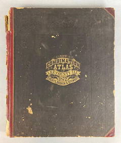
1872 New Combination Atlas of Lee County Illinois BookMatthew Bullock Auctioneers4.7(1.8k)See Sold PriceFeb 24, 2024
Battle of the Nile: Disposition of the English & French Fleets, at the Commencement of the Action,Trillium Antique Prints & Rare Books4.5(30)See Sold PriceFeb 24, 2024
Putnam - First Map of the State of Ohio by Rufus PutnamTrillium Antique Prints & Rare Books4.5(30)See Sold PriceFeb 24, 2024
Carey, pub. 1796 - A Chart of the West IndiesTrillium Antique Prints & Rare Books4.5(30)See Sold PriceFeb 24, 2024
Carey, pub. 1796 - Map of the State of MarylandTrillium Antique Prints & Rare Books4.5(30)See Sold PriceFeb 24, 2024
Carey, pub. 1796 - Map of GeorgiaTrillium Antique Prints & Rare Books4.5(30)See Sold PriceFeb 24, 2024
Carey, pub. 1796 - Map of The State of South CarolinaTrillium Antique Prints & Rare Books4.5(30)See Sold PriceFeb 24, 2024
Carey, pub. 1796 - Map of KentuckyTrillium Antique Prints & Rare Books4.5(30)See Sold PriceFeb 24, 2024
Carey, pub. 1796 - Map of the Tennassee State formerly part of North Carolina (Tennessee)Trillium Antique Prints & Rare Books4.5(30)See Sold PriceFeb 24, 2024
De Jode, Rare, pub. 1593 - Map of the Czech Republic or Kingdom of Bohemia (Chorographia insignisTrillium Antique Prints & Rare Books4.5(30)See Sold PriceFeb 24, 2024
De Jode, Rare, pub. 1593 - Map of the Middle East, Eastern Asia (Primae Partis Asiae accurataTrillium Antique Prints & Rare Books4.5(30)See Sold PriceFeb 24, 2024
Egill Jacobsen and Asger Jorn books with 6 lithographsConcept Art Gallery4.7(509)See Sold PriceMar 06, 2024
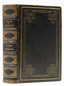
Bookbinding.- Binding.- Zaehnsdorf (Joseph W.) The Art of Bookbinding, first edition, George Bell &Forum Auctions4.3(53)See Sold PriceFeb 29, 2024