Sold1876 NAUTICAL CHART, CUTTYHUNK TO BLOCK ISLANDBY C.P. PATTERSON, 39" X 28 1/2", WATER DAMAGE LOWER LEFT CORNER AND TWO 1" TEARS TO RIGHT MARGIN.See Sold Price
SoldLOT OF SEVEN ROLL UP CHARTS, TO INCLUDE: 1)"CUTTYHUNK TO BLOCK ISLAND, INCLUDING NARRAGANSETT BAY, 1876", 41 1/2" X 30", SHOWS LIGHT FOCING, MINOR CHIPPING TO EDGE, AND ONE 2" TEARS ON THE TOP BORDER. 2) ROLL UP CHART OF THE FALKLAND ISLANDS,See Sold Price
SoldLand Ho! Antique Block Island Sound, RI USCGDescription: Ahoy! Antique U.S. Coast Guard nautical chart of Block Island Sound and Approaches. Numbered C. & G. S. 1211; published 1968. Material: paper. Measurement: approximate 36" x 41" (INCHES).See Sold Price
Land Ho! Antique Block Island Sound, RI USCGDescription: Ahoy! Antique U.S. Coast Guard nautical chart of Block Island Sound and Approaches. Earlier publication than lot previously described. Numbered C. & G. S. 1211; published 1963. Material:See Sold Price
Land Ho! Antique Block Island Sound, RI USCGDescription: Ahoy! Antique U.S. Coast Guard nautical chart of Block Island Sound and Approaches. Earlier publication than lot previously described. Numbered C. & G. S. 1211; published 1963. Material:See Sold Price
SoldEarly 20th C. Chart of Cuttyhunk to Block IslandOriginal 1904 chart showing the waters of Cuttyhunk to Block Island including Narragansett Bay. Published by the coast and geodetic survey. Showing the shoreline from Providence to Rocky Point, RhodeSee Sold Price
Sold1885 Chart of Narraganset BayU.S. Coast and geodetic survey chart titled Cuttyhunk to Block Island including Narraganset Bay, this being a 1891 edition. Heavily stained. Framed in black. 31” x 42”. Also included with this lotSee Sold Price
SoldNautical Map / Sea Chart, #362 Block Island Sound andDescription: Nautical Map / Sea Chart, United States East Coast, New York, Long Island, Block Island Sound and Gardiner's Bay, 6th edition, Feb 10/69; Shipping: $20; different rate to California, AlasSee Sold Price
Coast Chart No. 113. Cuttyhunk to Block Island Including Narragansett Bay...Publication Date: 1890-04-01 Title: Coast Chart No. 113. Cuttyhunk to Block Island Including Narragansett Bay... Cartographer: U.S. COAST & GEODETIC SURVEY Publisher: U.S.C. & G.S. Height: 37.5 Width:See Sold Price
Nautical Map / Sea Chart, #362 Block Island Sound andDescription: Nautical Map / Sea Chart, United States East Coast New York - Long Island Block Island Sound and Gardiners Bay 2nd edition oct 15th/62 edition, stamped knutson marine center inc. mill damSee Sold Price
Nautical Map / Sea Chart, #269 Block IslandDescription: Nautical Map / Sea Chart, United States East Coast, Rhode Island - Block Island, 1st edition july 7 /52 ; revised 6/25/56, stamped "huntington hardware corp agents for U.S coast & geodetiSee Sold Price
Coast Chart No. 113. Cuttyhunk to Block IslandTitle: Coast Chart No. 113. Cuttyhunk to Block Island Including Narragansett Bay... Publication Date: 1890-04-01 Cartographer: U.S. COAST & GEODETIC SURVEY Publisher: U.S.C. & G.S. Description: LargeSee Sold Price
Nautical Map / Sea Chart, #362 Block Island Sound andDescription: Nautical Map / Sea Chart, United States East Coast, New York, Long Island, Block Island Sound and Gardiner's Bay, 6th edition, Feb 10/69; Shipping: $20; different rate to California, AlasSee Sold Price
Nautical Map / Sea Chart, #362 Block Island Sound andDescription: Nautical Map / Sea Chart, United States East Coast, New York, Long Island, Block Island Sound and Gardiner's Bay, 6th edition, Feb 10/69; Shipping: $20; different rate to California, AlasSee Sold Price
Nautical Map / Sea Chart, #362 Block Island Sound andDescription: Nautical Map / Sea Chart, United States East Coast, New York, Long Island, Block Island Sound and Gardiner's Bay, 6th edition, Feb 10/69; Shipping: $20; different rate to California, AlasSee Sold Price
Nautical Map / Sea Chart, #362 Block Island Sound andDescription: Nautical Map / Sea Chart, United States East Coast, New York, Long Island, Block Island Sound and Gardiner's Bay, 6th edition, Feb 10/69; Shipping: $20; different rate to California, AlasSee Sold Price
Nautical Map / Sea Chart, #362 Block Island Sound andDescription: Nautical Map / Sea Chart, United States East Coast, New York, Long Island, Block Island Sound and Gardiner's Bay, 6th edition, Feb 10/69; Shipping: $20; different rate to California, AlasSee Sold Price
Nautical Map / Sea Chart, #362 Block Island Sound andDescription: Nautical Map / Sea Chart, United States East Coast New York - Long Island Block Island Sound and Gardiners Bay 2nd edition oct 15th/62 edition, stamped knutson marine center inc. mill damSee Sold Price
Nautical Map / Sea Chart, #362 Block Island Sound andDescription: Nautical Map / Sea Chart, United States East Coast, New York, Long Island, Block Island Sound and Gardiner's Bay, 6th edition, Feb 10/69; Shipping: $20; different rate to California, AlasSee Sold Price
Large Official Captain's Chart Centering On NewportU.S. Coast Survey. Coast Chart No. 113. Cuttyhunk to Block Island Including Narragansett Bay... Lithographed map. U.S. Coast and Geodetic Survey, 1890. 37 ½" x 27" sheet. Large official sea chart wSee Sold Price
Collection of 10 Nautical ChartsCollection of 10 nautical charts, to include: Point Judith and Block Island, 25" h x 45" w; Narragansett Bay, 47" h x 35" w; Long Island Sound, 30" h x 45" w; Delaware Bay, 39 x 33 1/2 "; Quoddy RoadsSee Sold Price
Sold1866 NAUTICAL CHART, COAST OF THE UNITED STATES,MONOMOY AND NANTUCKET SHOALS TO BLOCK ISLAND, A.D. BACHE, 40" LONG, 29" WIDE. EXCELLENT CONDITION, OLD HAND WRITTEN REMARKS ON EDGE.See Sold Price
5 Stephen Robin Artist Painted BlocksB.S. Slosberg, Inc. Auctioneers4.5(381)See Sold PriceFeb 27, 2024
LATE 18TH C. VERY LARGE CHART OF NORTHEAST CANADA BY DES BARRES (1721-1824), 1780, FRAMEDThomaston Place Auction Galleries4.4(393)See Sold PriceFeb 24, 2024
EARLY 18TH C. DUTCH CHART OF PACIFIC OCEAN BY FREDERIK DE WIT (1629-1706) WITH CALIFORNIA AS ANThomaston Place Auction Galleries4.4(393)See Sold PriceFeb 24, 2024
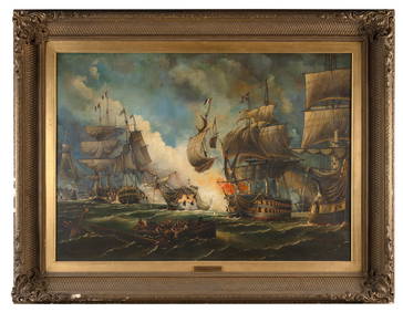
WILLIAM GRIFFIN (United Kingdom, 19th Century), "Battle of the Glorious 1st June"., Oil on canvas,Eldred's4.7(419)See Sold PriceFeb 27, 2024
CHART "LONG ISLAND SOUND FROM NEW YORK TO MONTOCK POINT ..." New York, 1830 21" x 77" sight. FramedEldred's4.7(419)See Sold PriceFeb 27, 2024
CHART "SOUTHERN COAST OF LONG ISLAND FROM MONTAUK POINT TO EAST HAMPTON" Circa 1877 11.25" x 22.75"Eldred's4.7(419)See Sold PriceFeb 27, 2024
Iron Mountain Of Long Island Sound Litho J GleasonThe Benefit Shop Foundation Inc.4.3(2.9k)See Sold PriceMar 06, 2024
[CIGARETTE CARDS]. A Complete Set of 50 “Light-House Series...Potter & Potter Auctions4.6(545)See Sold PriceMar 07, 2024
1764 Bellin Map of Lesser Antilles Northern Portion -- Petites Antilles ou Isles du Vent 3e. Partie.Jasper524.5(9.9k)See Sold PriceFeb 27, 2024
West Indies. South Coast of Jamaica from Port Royal to Pedro Bluff.Jasper524.5(9.9k)See Sold PriceFeb 27, 2024
West Indies Windward Lesser Antilles. Martinique (Belonging to France)Jasper524.5(9.9k)See Sold PriceFeb 27, 2024
Windward Islands and Spanish Main from the Latest Surveys 1860Jasper524.5(9.9k)See Sold PriceFeb 27, 2024
AFRICA. Pre 'Scramble for Africa'. BARTHOLOMEW 1876 old antique map plan chartJasper524.5(9.9k)See Sold PriceFeb 28, 2024
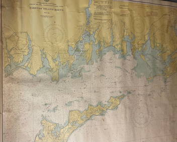
CHART: UNITED STATES - EAST COAST/ RHODE ISLAND - CONNECTICUT - NEW YORK/ Fishers IslandChurchill Galleries3.7(217)See Sold PriceFeb 26, 2024
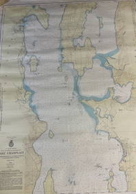
CHART: U.S LAKE SURVEYS/ LAKE CHAMPLAIN/ CUMBERLAND HEAD, NY and SAVAGE ISLAND, VT. TO FOUR BROTHERSChurchill Galleries3.7(217)See Sold PriceFeb 26, 2024
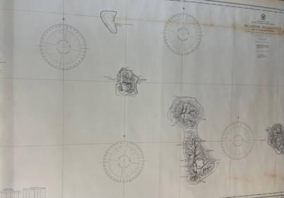
CHART: South Pacific Ocean / SOCIETY ISLANDS - WESTERN GROUP/ HUAHINE TO MAUPITI With theChurchill Galleries3.7(217)See Sold PriceFeb 26, 2024
1876 INTERNATIONAL EXHIBITION PACKAGE TICKET PHILADELPHIAConverse Auctions4.5(466)See Sold PriceMar 01, 2024
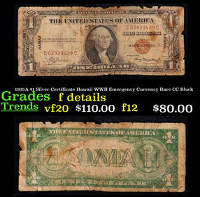
1935A $1 Silver Certificate Hawaii WWII Emergency Currency Rare CC Block Grades f+Key Date Coins4.4(1.4k)See Sold PriceFeb 28, 2024


![[CIGARETTE CARDS]. A Complete Set of 50 “Light-House Series... (1 of 1)](https://p1.liveauctioneers.com/928/318880/171361500_1_x.jpg?height=282&quality=70&version=1707501302)