ATLAS of ANTIENT GEOGRAPHY by SAMUEL BUTLER 1843John McInnis Auctioneers,LLC4.5(505)See Sold PriceFeb 24, 2024
18TH C. ANTIQUE MAP: FRENCH & INDIAN WAR, FRAMEDThomaston Place Auction Galleries4.4(393)See Sold PriceFeb 24, 2024
Rand McNally Railroad Map Cabinet w/ 21 Railroad MapsRail & Road Auctions4.6(165)See Sold PriceMar 08, 2024
Keith Haring - Ink on New York Map, Best Buddies, Inscribed, Signed, and DatedSapphire Auction Gallery4.1(67)See Sold PriceMar 02, 2024
LATE 17TH C. FRENCH MAP OF THE NEW WORLD BY ALEXIS-HUBERT JAILLOT (1632-1712)Thomaston Place Auction Galleries4.4(393)See Sold PriceFeb 24, 2024
Central Railroad of New Jersey Map of Sandy Hook Route-ca. 1903JM Hobby Supply and Railroad Artifact Auctions4.4(127)See Sold PriceFeb 24, 2024
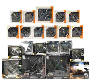
Lot of Six Mixed Atlas Box Cars-HO Scale-New in BoxJM Hobby Supply and Railroad Artifact Auctions4.4(127)See Sold PriceFeb 25, 2024
Rand McNally/Santa Fe Railroad Map of Iowa-1912JM Hobby Supply and Railroad Artifact Auctions4.4(127)See Sold PriceFeb 24, 2024
NICOLAES VISSCHER (NETHERLANDS, 1618-1709) MAP OF THE NEW WORLDThomaston Place Auction Galleries4.4(393)See Sold PriceFeb 24, 2024
17TH C. WORLD MAP BY NICOLAES VISSCHER (NETHERLANDS, 1618-1709)Thomaston Place Auction Galleries4.4(393)See Sold PriceFeb 24, 2024
Lot of Six Mixed Atlas Cabooses-HO Scale-New in BoxJM Hobby Supply and Railroad Artifact Auctions4.4(127)See Sold PriceFeb 25, 2024
1869 Mitchell Map of US Midwest -- XIV Ohio, Kentucky,Title: 1869 Mitchell Map of US Midwest -- XIV Ohio, Kentucky, Indiana, Illinois, Iowa and Missouri [verso] XV Michigan and Wisconsin Cartographer: S Mithchell Year / Place: 1869, Philadelphia Map DimeSee Sold Price
1869 Mitchell Map of US Midwest -- XIV Ohio, Kentucky,Title: 1869 Mitchell Map of US Midwest -- XIV Ohio, Kentucky, Indiana, Illinois, Iowa and Missouri [verso] XV Michigan and Wisconsin Cartographer: S Mithchell Year / Place: 1869, Philadelphia Map DimeSee Sold Price
1869 Mitchell Map of US Midwest -- XIV Ohio, Kentucky, Indiana, Illinois, Iowa and Missouri [verso]Title: 1869 Mitchell Map of US Midwest -- XIV Ohio, Kentucky, Indiana, Illinois, Iowa and Missouri [verso] XV Michigan and Wisconsin Cartographer: S Mithchell Year / Place: 1869, Philadelphia Map DimeSee Sold Price
1869 Mitchell Map of US Midwest -- XIV Ohio, Kentucky,Title/Content of Map: 1869 Mitchell Map of US Midwest -- XIV Ohio, Kentucky, Indiana, Illinois, Iowa and Missouri [verso] XV Michigan and Wisconsin Cartographer: S Mithchell Year/Place: 1869, PhiladelSee Sold Price
SoldMeyer: Antique Map of the U.S. Midwest, 1852Map: Die Staaten von Missouri, Illinois, Indiana, Ohio, Kentucky & Tennessee Cartographer: Bibliographischen Instituts. Place & Date: Hildburghausen / 1852 Size: 7 5/8" x 10 3/4" Condition: original cSee Sold Price
1869 Mitchell Map of US [verso] Maine, New Hamshire andTitle/Content of Map: 1869 Mitchell Map of US [verso] Maine, New Hamshire and Vermont -- VII Map of the United States [verso] VIII Maine, New Hamshire and Vermont Cartographer: S Mithchell Year/Place:See Sold Price
1869 Mitchell Map of US [verso] Maine, New Hamshire andTitle: 1869 Mitchell Map of US [verso] Maine, New Hamshire and Vermont -- VII Map of the United States [verso] VIII Maine, New Hamshire and Vermont Cartographer: S Mithchell Year / Place: 1869, PhiladSee Sold Price
1869 Mitchell Map of US [verso] Maine, New Hamshire andTitle: 1869 Mitchell Map of US [verso] Maine, New Hamshire and Vermont -- VII Map of the United States [verso] VIII Maine, New Hamshire and Vermont Cartographer: S Mithchell Year / Place: 1869, PhiladSee Sold Price
Sold1869 Mitchell Map of Western US [verso] Mexico andTitle: 1869 Mitchell Map of Western US [verso] Mexico and Central America -- XIX California, Oregon, Idaho, Utah, Nevada, Arizona and Washington [verso] XX Mexico and Central America Cartographer: S MSee Sold Price
1869 Mitchell Map of Western US [verso] Mexico andTitle/Content of Map: 1869 Mitchell Map of Western US [verso] Mexico and Central America -- XIX California, Oregon, Idaho, Utah, Nevada, Arizona and Washington [verso] XX Mexico and Central America CaSee Sold Price
1852 Mitchell Map of Midwest United States and KentuckyTitle/Content of Map: 1852 Mitchell Map of Midwest United States and Kentucky -- No. 14 Map of the Chief Part of the Western States including Western Virginia Date Printed: 1852 Philadelphia CartograpSee Sold Price
1852 Mitchell Map of Midwest United States and KentuckyTitle/Content of Map: 1852 Mitchell Map of Midwest United States and Kentucky -- No. 14 Map of the Chief Part of the Western States including Western Virginia Date Printed: 1852 Philadelphia CartograpSee Sold Price
1853 Colton Map of the US Midwest -- Guide through Ohio, Michigan, Indiana, Illinois, Missouri,Title: 1853 Colton Map of the US Midwest -- Guide through Ohio, Michigan, Indiana, Illinois, Missouri, Wisconsin & Iowa. Showing the Township Lines of the United States Surveys … Cartographer: JSee Sold Price
1852 Mitchell Map of Midwest United States and KentuckyTitle/Content of Map: 1852 Mitchell Map of Midwest United States and Kentucky -- No. 14 Map of the Chief Part of the Western States including Western Virginia Date: 1852 Philadelphia Cartographer: S MSee Sold Price
1852 Mitchell Map of Midwest United States and KentuckyReserve Reduced! Title/Content of Map: 1852 Mitchell Map of Midwest United States and Kentucky -- No. 14 Map of the Chief Part of the Western States including Western Virginia Date: 1852 PhiladelphiaSee Sold Price
1891 Mitchell Map of Ohio, Michigan, Indiana and Kentucky -- Map of Ohio, Michigan, Indiana andTitle: 1891 Mitchell Map of Ohio, Michigan, Indiana and Kentucky -- Map of Ohio, Michigan, Indiana and Kentucky Cartographer: S Mitchell Year / Place: 1891, Philadelphia Map Dimension (in.): 10.6 X 8.See Sold Price
1852 Mitchell Map of Midwest United States and KentuckyTitle: 1852 Mitchell Map of Midwest United States and Kentucky -- No. 14 Map of the Chief Part of the Western States including Western Virginia Date: 1852 Philadelphia Cartographer: S Mitchell / CowpeSee Sold Price
1852 Mitchell Map of Midwest United States and KentuckyTitle: 1852 Mitchell Map of Midwest United States and Kentucky -- No. 14 Map of the Chief Part of the Western States including Western Virginia Cartographer: S Mitchell / Cowperthwait & Co. Year / PlaSee Sold Price
1852 Mitchell Map of Midwest United States and KentuckyTitle/Content of Map: 1852 Mitchell Map of Midwest United States and Kentucky -- No. 14 Map of the Chief Part of the Western States including Western Virginia Cartographer: S Mitchell / Cowperthwait &See Sold Price
1853 Colton Map of the US Midwest -- Guide throughTitle: 1853 Colton Map of the US Midwest -- Guide through Ohio, Michigan, Indiana, Illinois, Missouri, Wisconsin & Iowa. Showing the Township Lines of the United States Surveys … Cartographer: J ColSee Sold Price
1853 Colton Map of the US Midwest -- Guide throughTitle/Content of Map: 1853 Colton Map of the US Midwest -- Guide through Ohio, Michigan, Indiana, Illinois, Missouri, Wisconsin & Iowa.Showing the Township Lines of the United States Surveys … Date:See Sold Price
1853 Colton Map of the US Midwest -- Guide throughTitle: 1853 Colton Map of the US Midwest -- Guide through Ohio, Michigan, Indiana, Illinois, Missouri, Wisconsin & Iowa. Showing the Township Lines of the United States Surveys … Cartographer: J ColSee Sold Price
1853 Colton Map of the US Midwest -- Guide throughTitle/Content of Map: 1853 Colton Map of the US Midwest -- Guide through Ohio, Michigan, Indiana, Illinois, Missouri, Wisconsin & Iowa. Showing the Township Lines of the United States Surveys … CartSee Sold Price
1853 Colton Map of the US Midwest -- Guide throughTitle/Content of Map: 1853 Colton Map of the US Midwest -- Guide through Ohio, Michigan, Indiana, Illinois, Missouri, Wisconsin & Iowa.Showing the Township Lines of the United States Surveys … Date:See Sold Price
Central Railroad of New Jersey Map of Sandy Hook Route-ca. 1903JM Hobby Supply and Railroad Artifact Auctions4.4(127)See Sold PriceFeb 24, 2024
Hammonds Map of Kentucky and Tennessee Railroads-1910JM Hobby Supply and Railroad Artifact Auctions4.4(127)See Sold PriceFeb 24, 2024
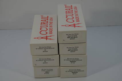
Seven Mixed Accurail/5th Ave Car Shops Midwest RR Freight Cars-HO Scale-New in BoxJM Hobby Supply and Railroad Artifact Auctions4.4(127)See Sold PriceFeb 25, 2024
FLYING A TOURING SERVICE U.S. ROAD MAPS TIN WALL DISPLAY.Dan Morphy Auctions4.2(1.3k)See Sold PriceFeb 25, 2024
Early 1900's Railway Service Map, Illinois, Ohio, Indiana, Kentucky, TennesseeConnoisseur Auctions3.9(336)See Sold PriceFeb 24, 2024
1963 J.F.K. for US PRESIDENT RE-ELECTION MATERIALJohn McInnis Auctioneers,LLC4.5(505)See Sold PriceFeb 25, 2024
Civil War Map, Positions of the Army of the Ohio Front oh Dalton GA Dated 1864 34"L x 24"TSwisher Bros. Auction LLC4.4(255)See Sold PriceFeb 24, 2024
Civil War Map, Positions of the 16th Army Corps Dated 1864 34"L x 24"TSwisher Bros. Auction LLC4.4(255)See Sold PriceFeb 24, 2024
4 3/16" Decatur. Bloomfield Chert. Partain and Putty COA'sTony Putty Artifacts4.7(404)See Sold PriceMar 09, 2024
[POLITICS - RECONSTRUCTION]. The Cincinnati Commercial. Speeches of the Campaign of 1866 in theFreeman's | Hindman4.4(1.6k)See Sold PriceFeb 27, 2024
[VIETNAM]. A group of approx. 120 photographs assembled by African American soldier Vernon CliftonFreeman's | Hindman4.4(1.6k)See Sold PriceFeb 27, 2024
Putnam - First Map of the State of Ohio by Rufus PutnamTrillium Antique Prints & Rare Books4.5(32)See Sold PriceFeb 24, 2024
Carey, pub. 1796 - Map of KentuckyTrillium Antique Prints & Rare Books4.5(32)See Sold PriceFeb 24, 2024
ATTRIBUTED TO DIXIE SELDEN (1871-1936) "COASTAL SCENE".Amelia Jeffers, Auctioneers & Appraisers4.5(120)See Sold PriceMar 07, 2024
Twenty-one boxed die-cast scale models of mainly WWII aircraft by Unimax and Ixo, ((21))Bonhams4(320)See Sold PriceMar 01, 2024
Francis McNally - Antique Map of Ohio, Indiana & KentuckyProverde Auctions4.3(3)See Sold PriceFeb 28, 2024


![1869 Mitchell Map of US Midwest -- XIV Ohio, Kentucky, Indiana, Illinois, Iowa and Missouri [verso] (1 of 2)](https://p1.liveauctioneers.com/5584/274166/143946233_1_x.jpg?height=282&quality=70&version=1673389176)


![1869 Mitchell Map of US [verso] Maine, New Hamshire and (1 of 2)](https://p1.liveauctioneers.com/5584/179983/90569379_1_x.jpg?height=282&quality=70&version=1601417445)
![1869 Mitchell Map of US [verso] Maine, New Hamshire and (1 of 2)](https://p1.liveauctioneers.com/5584/195879/98794792_1_x.jpg?height=282&quality=70&version=1614724478)
![1869 Mitchell Map of US [verso] Maine, New Hamshire and (1 of 2)](https://p1.liveauctioneers.com/5584/190355/95871752_1_x.jpg?height=282&quality=70&version=1609884614)
![1869 Mitchell Map of Western US [verso] Mexico and (1 of 2)](https://p1.liveauctioneers.com/5584/188299/94765046_1_x.jpg?height=282&quality=70&version=1608072723)
![1869 Mitchell Map of Western US [verso] Mexico and (1 of 2)](https://p1.liveauctioneers.com/5584/179019/90118111_1_x.jpg?height=282&quality=70&version=1600206230)


![[POLITICS - RECONSTRUCTION]. The Cincinnati Commercial. Speeches of the Campaign of 1866 in the (1 of 11)](https://p1.liveauctioneers.com/197/319238/171468091_1_x.jpg?height=282&quality=70&version=1707520367)
![[VIETNAM]. A group of approx. 120 photographs assembled by African American soldier Vernon Clifton (1 of 6)](https://p1.liveauctioneers.com/197/319238/171468143_1_x.jpg?height=282&quality=70&version=1707520367)