ATLAS of ANTIENT GEOGRAPHY by SAMUEL BUTLER 1843John McInnis Auctioneers,LLC4.5(505)See Sold PriceFeb 24, 2024
18TH C. ANTIQUE MAP: FRENCH & INDIAN WAR, FRAMEDThomaston Place Auction Galleries4.4(394)See Sold PriceFeb 24, 2024
Rand McNally Railroad Map Cabinet w/ 21 Railroad MapsRail & Road Auctions4.6(165)See Sold PriceMar 08, 2024
Keith Haring - Ink on New York Map, Best Buddies, Inscribed, Signed, and DatedSapphire Auction Gallery4.1(67)See Sold PriceMar 02, 2024
LATE 17TH C. FRENCH MAP OF THE NEW WORLD BY ALEXIS-HUBERT JAILLOT (1632-1712)Thomaston Place Auction Galleries4.4(394)See Sold PriceFeb 24, 2024
Central Railroad of New Jersey Map of Sandy Hook Route-ca. 1903JM Hobby Supply and Railroad Artifact Auctions4.4(127)See Sold PriceFeb 24, 2024
Lot of Six Mixed Atlas Box Cars-HO Scale-New in BoxJM Hobby Supply and Railroad Artifact Auctions4.4(127)See Sold PriceFeb 25, 2024
Rand McNally/Santa Fe Railroad Map of Iowa-1912JM Hobby Supply and Railroad Artifact Auctions4.4(127)See Sold PriceFeb 24, 2024
NICOLAES VISSCHER (NETHERLANDS, 1618-1709) MAP OF THE NEW WORLDThomaston Place Auction Galleries4.4(394)See Sold PriceFeb 24, 2024
17TH C. WORLD MAP BY NICOLAES VISSCHER (NETHERLANDS, 1618-1709)Thomaston Place Auction Galleries4.4(394)See Sold PriceFeb 24, 2024
Lot of Six Mixed Atlas Cabooses-HO Scale-New in BoxJM Hobby Supply and Railroad Artifact Auctions4.4(127)See Sold PriceFeb 25, 2024
Sold1869 Mitchell Map of the Carribean [verso] SouthTitle: 1869 Mitchell Map of the Carribean [verso] South America -- XXI Map of the West Indies [verso] XXIV South America Cartographer: S Mithchell Year / Place: 1869, Philadelphia Map Dimension (in.):See Sold Price
1869 Mitchell Map of the Carribean [verso] SouthTitle/Content of Map: 1869 Mitchell Map of the Carribean [verso] South America -- XXI Map of the West Indies [verso] XXIV South America Cartographer: S Mithchell Year/Place: 1869, Philadelphia Size: 1See Sold Price
1869 Mitchell Map of the Northern and [verso] WesternTitle/Content of Map: 1869 Mitchell Map of the Northern and [verso] Western Portions of South America -- XXV Venezuela, United States of Columbia and Ecuador [verso] XXVII Peru and Bolivia CartographeSee Sold Price
1869 Mitchell Map of the Northern and [verso] WesternTitle: 1869 Mitchell Map of the Northern and [verso] Western Portions of South America -- XXV Venezuela, United States of Columbia and Ecuador [verso] XXVII Peru and Bolivia Cartographer: S MithchellSee Sold Price
1869 Mitchell Map of South America's Southern ConeTitle: 1869 Mitchell Map of South America's Southern Cone [verso] Europe -- XXIX Europe [verso] XXVIII Chili, Papraguay, the Argentine Confederation, and Uruguay Cartographer: S Mithchell Year / PlaceSee Sold Price
Sold1869 Mitchell Map of Africa [verso] Oceania -- XLTitle: 1869 Mitchell Map of Africa [verso] Oceania -- XL Africa [verso] XLIII Oceania Including Malaysia, Australia and Polynesia Cartographer: S Mithchell Year / Place: 1869, Philadelphia Map DimensiSee Sold Price
1869 Mitchell Map of US [verso] Maine, New Hamshire andTitle/Content of Map: 1869 Mitchell Map of US [verso] Maine, New Hamshire and Vermont -- VII Map of the United States [verso] VIII Maine, New Hamshire and Vermont Cartographer: S Mithchell Year/Place:See Sold Price
1869 Mitchell Map of US [verso] Maine, New Hamshire andTitle: 1869 Mitchell Map of US [verso] Maine, New Hamshire and Vermont -- VII Map of the United States [verso] VIII Maine, New Hamshire and Vermont Cartographer: S Mithchell Year / Place: 1869, PhiladSee Sold Price
1869 Mitchell Map of Western [verso] Eastern Hemispheres -- The Western Hemisphere Map No. 1…Title: 1869 Mitchell Map of Western [verso] Eastern Hemispheres -- The Western Hemisphere Map No. 1… [verso] The Eastern Hemisphere Map No. 2… Cartographer: S Mithchell Year / Place: 1869,See Sold Price
1869 Mitchell Map of Western [verso] EasternTitle/Content of Map: 1869 Mitchell Map of Western [verso] Eastern Hemispheres -- The Western Hemisphere Map No. 1… [verso] The Eastern Hemisphere Map No. 2… Cartographer: S Mithchell Year/Place:See Sold Price
1869 Mitchell Map of Western [verso] EasternTitle: 1869 Mitchell Map of Western [verso] Eastern Hemispheres -- The Western Hemisphere Map No. 1… [verso] The Eastern Hemisphere Map No. 2… Cartographer: S Mithchell Year / Place: 1869, PhiladeSee Sold Price
1869 Mitchell Map of Western [verso] EasternTitle: 1869 Mitchell Map of Western [verso] Eastern Hemispheres -- The Western Hemisphere Map No. 1… [verso] The Eastern Hemisphere Map No. 2… Cartographer: S Mithchell Year / Place: 1869, PhiladeSee Sold Price
1869 Mitchell Map of US [verso] Maine, New Hamshire andTitle: 1869 Mitchell Map of US [verso] Maine, New Hamshire and Vermont -- VII Map of the United States [verso] VIII Maine, New Hamshire and Vermont Cartographer: S Mithchell Year / Place: 1869, PhiladSee Sold Price
Sold1869 Mitchell Map of Western US [verso] Mexico andTitle: 1869 Mitchell Map of Western US [verso] Mexico and Central America -- XIX California, Oregon, Idaho, Utah, Nevada, Arizona and Washington [verso] XX Mexico and Central America Cartographer: S MSee Sold Price
1869 Mitchell Map of North America [verso] Eastern Canada -- III Map of North America [verso] IVTitle: 1869 Mitchell Map of North America [verso] Eastern Canada -- III Map of North America [verso] IV Dominion of Canada Cartographer: S Mithchell Year / Place: 1869, Philadelphia Map Dimension (in.See Sold Price
1869 Mitchell Map of North America [verso] EasternTitle: 1869 Mitchell Map of North America [verso] Eastern Canada -- III Map of North America [verso] IV Dominion of Canada Cartographer: S Mithchell Year / Place: 1869, Philadelphia Map Dimension (in.See Sold Price
1869 Mitchell Map of North America [verso] EasternTitle/Content of Map: 1869 Mitchell Map of North America [verso] Eastern Canada -- III Map of North America [verso] IV Dominion of Canada Cartographer: S Mithchell Year/Place: 1869, Philadelphia Size:See Sold Price
1869 Mitchell Map of Western US [verso] Mexico andTitle/Content of Map: 1869 Mitchell Map of Western US [verso] Mexico and Central America -- XIX California, Oregon, Idaho, Utah, Nevada, Arizona and Washington [verso] XX Mexico and Central America CaSee Sold Price
1869 Mitchell Map of North America [verso] EasternTitle: 1869 Mitchell Map of North America [verso] Eastern Canada -- III Map of North America [verso] IV Dominion of Canada Cartographer: S Mithchell Year / Place: 1869, Philadelphia Map Dimension (in.See Sold Price
Sold1876 Mitchell Map of the Caribbean and [verso] SouthTitle/Content of Map: 1876 Mitchell Map of the Caribbean and [verso] South America -- XXI Map of the West Indies [verso] XXIV South America Date: 1876, PhiladelphiaCartographer: S Mitchell Size: 8 X 1See Sold Price
1876 Mitchell Map of the Caribbean and [verso] SouthTitle/Content of Map: 1876 Mitchell Map of the Caribbean and [verso] South America -- XXI Map of the West Indies [verso] XXIV South America Date: 1876, Philadelphia Cartographer: S Mitchell Size: 8 XSee Sold Price
1876 Mitchell Map of the Caribbean and [verso] SouthTitle/Content of Map: 1876 Mitchell Map of the Caribbean and [verso] South America -- XXI Map of the West Indies [verso] XXIV South America Date: 1876, Philadelphia Cartographer: S Mitchell Size: 8 XSee Sold Price
1876 Mitchell Map of the Caribbean and [verso] SouthTitle: 1876 Mitchell Map of the Caribbean and [verso] South America -- XXI Map of the West Indies [verso] XXIV South America Date: 1876, Philadelphia Cartographer: S Mitchell Size: 8 X 10.8 in. AdditiSee Sold Price
1869 Mitchell Map of Great Britain, Ireland [verso]Title/Content of Map: 1869 Mitchell Map of Great Britain, Ireland [verso] Scandinavia-- XXX Great Britain and Ireland [verso] XXXI The Western Part of Russia with Denmark Sweden & Norway Cartographer:See Sold Price
Lake Superior and Mississippi River RR 1869 Seven Percent Bonds Book/Report-1869JM Hobby Supply and Railroad Artifact Auctions4.4(127)See Sold PriceFeb 24, 2024
Michigan Southern and Northern Indiana RR 14th Annual Report-February 28, 1869JM Hobby Supply and Railroad Artifact Auctions4.4(127)See Sold PriceFeb 24, 2024
John Lynas Gray (UK,1869-1933) watercolor painting antiqueBroward Auction Gallery4.7(300)See Sold PriceMar 17, 2024
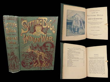
1891 Sitting Bull 1st ed Life Native American Sioux Indians DAKOTA Ghost DanceSchilb Antiquarian Rare Books4.8(431)See Sold PriceMar 10, 2024
17TH C. MAP OF THE BERKSHIRES BY JOHN SPEED, FRAMEDThomaston Place Auction Galleries4.4(394)See Sold PriceFeb 24, 2024
Tony Cardella (French,1898-1976) oil paintingBroward Auction Gallery4.7(300)See Sold PriceApr 14, 2024
Jean Hugo (French, 1894–1984) - Les Sorcières, WarwickFreeman's | Hindman4.5(158)See Sold PriceFeb 28, 2024
Catherwood - General View of Uxmal, Taken from the Archway of Las Monjas, Looking SouthTrillium Antique Prints & Rare Books4.5(33)See Sold PriceFeb 24, 2024
Carey, pub. 1796 - Map of the Tennassee State formerly part of North Carolina (Tennessee)Trillium Antique Prints & Rare Books4.5(33)See Sold PriceFeb 24, 2024
1822 MAP of NORTH & SOUTH AMERICA GEOGRAPHICAL STATISTICAL HISTORICAL antiqueJasper524.5(9.9k)See Sold PriceFeb 27, 2024
Eva Bouzard-Hui "You Need Wheels..." Mixed MediaAuctions at Showplace4.6(744)See Sold PriceFeb 13, 2025


![1869 Mitchell Map of the Carribean [verso] South First Image](https://p1.liveauctioneers.com/5584/194427/98040491_1_x.jpg?height=282&quality=95&version=1613575397&width=282)

![1869 Mitchell Map of the Carribean [verso] South First Image](https://p1.liveauctioneers.com/5584/194427/98040491_1_x.jpg?height=282&quality=1&version=1613575397&width=282)


![1869 Mitchell Map of the Carribean [verso] South (1 of 2)](https://p1.liveauctioneers.com/5584/194427/98040491_1_x.jpg?height=282&quality=70&version=1613575397)
![1869 Mitchell Map of the Carribean [verso] South (1 of 2)](https://p1.liveauctioneers.com/5584/179019/90118212_1_x.jpg?height=282&quality=70&version=1600206230)
![1869 Mitchell Map of the Northern and [verso] Western (1 of 2)](https://p1.liveauctioneers.com/5584/179019/90117893_1_x.jpg?height=282&quality=70&version=1600206230)
![1869 Mitchell Map of the Northern and [verso] Western (1 of 2)](https://p1.liveauctioneers.com/5584/194427/98040333_1_x.jpg?height=282&quality=70&version=1613575397)

![1869 Mitchell Map of Africa [verso] Oceania -- XL (1 of 2)](https://p1.liveauctioneers.com/5584/195879/98794856_1_x.jpg?height=282&quality=70&version=1614724478)
![1869 Mitchell Map of US [verso] Maine, New Hamshire and (1 of 2)](https://p1.liveauctioneers.com/5584/179983/90569379_1_x.jpg?height=282&quality=70&version=1601417445)
![1869 Mitchell Map of US [verso] Maine, New Hamshire and (1 of 2)](https://p1.liveauctioneers.com/5584/195879/98794792_1_x.jpg?height=282&quality=70&version=1614724478)
![1869 Mitchell Map of Western [verso] Eastern Hemispheres -- The Western Hemisphere Map No. 1… (1 of 2)](https://p1.liveauctioneers.com/5584/275309/144584413_1_x.jpg?height=282&quality=70&version=1673994422)
![1869 Mitchell Map of Western [verso] Eastern (1 of 2)](https://p1.liveauctioneers.com/5584/179610/90398453_1_x.jpg?height=282&quality=70&version=1600808901)
![1869 Mitchell Map of Western [verso] Eastern (1 of 2)](https://p1.liveauctioneers.com/5584/187575/94368539_1_x.jpg?height=282&quality=70&version=1607465981)
![1869 Mitchell Map of Western [verso] Eastern (1 of 2)](https://p1.liveauctioneers.com/5584/195010/98380725_1_x.jpg?height=282&quality=70&version=1614121450)
![1869 Mitchell Map of US [verso] Maine, New Hamshire and (1 of 2)](https://p1.liveauctioneers.com/5584/190355/95871752_1_x.jpg?height=282&quality=70&version=1609884614)
![1869 Mitchell Map of Western US [verso] Mexico and (1 of 2)](https://p1.liveauctioneers.com/5584/188299/94765046_1_x.jpg?height=282&quality=70&version=1608072723)
![1869 Mitchell Map of North America [verso] Eastern Canada -- III Map of North America [verso] IV (1 of 2)](https://p1.liveauctioneers.com/5584/274166/143946195_1_x.jpg?height=282&quality=70&version=1673389176)
![1869 Mitchell Map of North America [verso] Eastern (1 of 2)](https://p1.liveauctioneers.com/5584/198775/100468071_1_x.jpg?height=282&quality=70&version=1617141175)
![1869 Mitchell Map of North America [verso] Eastern (1 of 2)](https://p1.liveauctioneers.com/5584/182355/91727447_1_x.jpg?height=282&quality=70&version=1603285541)
![1869 Mitchell Map of Western US [verso] Mexico and (1 of 2)](https://p1.liveauctioneers.com/5584/179019/90118111_1_x.jpg?height=282&quality=70&version=1600206230)
![1869 Mitchell Map of North America [verso] Eastern (1 of 2)](https://p1.liveauctioneers.com/5584/190355/95871739_1_x.jpg?height=282&quality=70&version=1609884614)
![1876 Mitchell Map of the Caribbean and [verso] South (1 of 2)](https://p1.liveauctioneers.com/5584/153142/77325878_1_x.jpg?height=282&quality=70&version=1572400045)
![1876 Mitchell Map of the Caribbean and [verso] South (1 of 2)](https://p1.liveauctioneers.com/5584/144578/73088309_1_x.jpg?height=282&quality=70&version=1561513819)
![1876 Mitchell Map of the Caribbean and [verso] South (1 of 2)](https://p1.liveauctioneers.com/5584/148048/74811425_1_x.jpg?height=282&quality=70&version=1566334427)
![1876 Mitchell Map of the Caribbean and [verso] South (1 of 1)](https://p1.liveauctioneers.com/5584/135585/68835913_1_x.jpg?height=282&quality=70&version=1549414967)
![1869 Mitchell Map of Great Britain, Ireland [verso] (1 of 2)](https://p1.liveauctioneers.com/5584/180928/91034067_1_x.jpg?height=282&quality=70&version=1602020174)