ATLAS of ANTIENT GEOGRAPHY by SAMUEL BUTLER 1843John McInnis Auctioneers,LLC4.6(502)See Sold PriceFeb 24, 2024
18TH C. ANTIQUE MAP: FRENCH & INDIAN WAR, FRAMEDThomaston Place Auction Galleries4.4(386)See Sold PriceFeb 24, 2024
Rand McNally Railroad Map Cabinet w/ 21 Railroad MapsRail & Road Auctions4.6(165)See Sold PriceMar 08, 2024
Keith Haring - Ink on New York Map, Best Buddies, Inscribed, Signed, and DatedSapphire Auction Gallery4(67)See Sold PriceMar 02, 2024
LATE 17TH C. FRENCH MAP OF THE NEW WORLD BY ALEXIS-HUBERT JAILLOT (1632-1712)Thomaston Place Auction Galleries4.4(386)See Sold PriceFeb 24, 2024
Central Railroad of New Jersey Map of Sandy Hook Route-ca. 1903JM Hobby Supply and Railroad Artifact Auctions4.4(126)See Sold PriceFeb 24, 2024
Lot of Six Mixed Atlas Box Cars-HO Scale-New in BoxJM Hobby Supply and Railroad Artifact Auctions4.4(126)See Sold PriceFeb 25, 2024
Rand McNally/Santa Fe Railroad Map of Iowa-1912JM Hobby Supply and Railroad Artifact Auctions4.4(126)See Sold PriceFeb 24, 2024
NICOLAES VISSCHER (NETHERLANDS, 1618-1709) MAP OF THE NEW WORLDThomaston Place Auction Galleries4.4(386)See Sold PriceFeb 24, 2024
17TH C. WORLD MAP BY NICOLAES VISSCHER (NETHERLANDS, 1618-1709)Thomaston Place Auction Galleries4.4(386)See Sold PriceFeb 24, 2024
Lot of Six Mixed Atlas Cabooses-HO Scale-New in BoxJM Hobby Supply and Railroad Artifact Auctions4.4(126)See Sold PriceFeb 25, 2024
Sold1867 Impressive Colorful Map of the New York AreaHistoric Maps Colorful Hand-colored 1867 Folding Map of New York 1867-Dated, Hand-colored Map, 40 MILES AROUND NEW YORK by H.H. Lloyd, Very Fine. Impressive Hand-colored Pocket Map measuring 29" x 27"See Sold Price
1867 Impressive Colorful Map of the New York AreaHistoric Maps Impressive Colorful 1867 Folding Map of New York 1867-Dated, Impressive Hand-colored Map, 40 MILES AROUND NEW YORK by H.H. Lloyd, Very Fine. Impressive Hand-colored Pocket Map measuringSee Sold Price
1867 Impressive Colorful Map of the New York AreaHistoric Maps Colorful Hand-colored 1867 Folding Map of New York 1867-Dated, Hand-colored Map, 40 MILES AROUND NEW YORK by H.H. Lloyd, Very Fine. Impressive Hand-colored Pocket Map measuring 29" x 27"See Sold Price
SoldLLOYD, H. H. 40 Miles Around New York. New York: H. H.LLOYD, H. H. 40 Miles Around New York. New York: H. H. Lloyd & Co., 1867. Hand-colored engraved pocket map of New York's metropolitan region, issued folding, now flat, visible area 29 1/2 x 27 1/2 in.See Sold Price
Mott, Edwin D (1894-1962). Map of the New York World’sMott, Edwin D (1894-1962). Map of the New York World’s Fair. 1939. Large and impressive panoramic bird’s-eye map of the fair grounds, with key to numbered amusement and exhibit areas; planes and hSee Sold Price
Vintage Map Print - America - Map of Manhattan - New York - David RumseyDavid Rumsey Historical Map Collection. Manhattan, New York. Publisher: Unique Media Inc. Part of a series of colorful, printed, watercolor, artistic, bird's eye maps of areas and cities of the UnitedSee Sold Price
SoldBeers Atlas of New York and Vicinityincluding Westchester and Fairfield County maps, as well as a large fold-out of the overall area measuring 31" x 28" 1867 estimate 750/1000 Shipping available within the Continental USA (excludes insuSee Sold Price
SoldAntique Map: New York & Area - EngravingPensylvania Nova Jersey et Nova York cum Regionibus Ad Fluvium Delaware In America Sitis, Nova Delinatione ob oculos posita...Tobias Conrad Lotter (1717 - 1777). Engraved map with hand-color in part.See Sold Price
1870 Hardy Map of New York City1870 Hardy Map of New York City -- Map of the City of New York, Showing its Political Divisions and Subdivisions November 1870. J. Hardy, 1870 New York City, This large colorful map of New York City��See Sold Price
SoldScrimshaw Powder Horn Flask, Map of New YorkScrimshaw Powder Horn Flask, Map of New York. Scrimshaw map of New York area. Unicorn, lion, and crown coat of arms. Small townscape. Wood plug at top. 5"h.See Sold Price
Sold1758 Dated American Revolution English New York Map1758 Dated American Revolution English New York Map Powder Horn. A pre-Revolutionary War example with scrimshaw map of New York area, owner's name: "IRA NIGH" and a date 1758. Of one solid bull horn wSee Sold Price
Sold2 unbound map vols: FIELD OPERATIONS... 1901,1906[United States/USDA] 2 USDA map volumes in slipcases: FIELD OPERATIONS OF THE BUREAU OF SOILS. 1901; 1906. 8vo. Orig cloth slipcases. ++ 1901: 28 (of 31) large, colorful folding maps: New York; New JeSee Sold Price
SoldDATED 1811 NEW YORK POWDER HORNFine old scrimshawed powder horn belonging to William Brummell dated 1811 - attributed early 20th century. It has scrimshaw maps of New York area with various lakes and military forts and large red-coSee Sold Price
F.W. Beers 1867 Map of Pawling, New YorkMap of the Town of Pawling, Dutchess Co. NY. No. 38 re-published in 1983 by Central Press, Millbrook. In black frame. Measures 20.5 W by 16.5 inches H. Property of a Civil War Homestead in Pawling, NYSee Sold Price
F.W. Beers 1867 Map of Pawling, New YorkMap of the Town of Pawling, Dutchess Co. NY. No. 38 re-published in 1983 by Central Press, Millbrook. In black frame. Measures 20.5 W by 16.5 inches H. Property of a Civil War Homestead in Pawling, NYSee Sold Price
1867 Mitchell Map of New York and Brooklyn -- New YorkTitle: 1867 Mitchell Map of New York and Brooklyn -- New York and Brooklyn Cartographer: S Mitchell Year / Place: 1867 Philadelphia Map Dimension (in.): 13.3 x 20.6 in. This is an excellent map of NewSee Sold Price
Sold1867 Coltons New York Pocket Atlas Folding MapHistoric Maps 1867 "New York" Map Pocket Atlas Book by Colton & Co 1867 Colton's New York Map Pocket Atlas, Hardcover Booklet, Published by G. W. & C. B. Colton & Co, Very Fine. This is an original coSee Sold Price
Sold1887 Mitchell Map of New York City -- New York andTitle/Content of Map: 1887 Mitchell Map of New York City -- New York and Brooklyn Date: 1887, Philadelphia Cartographer: SS Mitchell Size: 13.5 x 21.1 in. This fascinating map of New York City area coSee Sold Price
Sold1867 Colton's New York Pocket Atlas Folding MapHistoric Maps 1867 "New York" Map Pocket Atlas Book by Colton & Co 1867 Colton's New York Map Pocket Atlas, Hardcover Booklet, Published by G. W. & C. B. Colton & Co, Very Fine. This is an original coSee Sold Price
Sold1867 Map of Stuyvesant Property New YorkShowing Stuyvesant and adjoining properties from Third Avenue to the East River and from First Street to Fourteenth Street. BY C B Holmes, City Surveyor. 29 x 35 inches.Note: Removed from the SteinwaySee Sold Price
Vintage Map Print - America - Colorful Fun Map of Manhattan - New York CityTitle/Artist: Vintage Map Print - America - Colorful Fun Map of Manhattan - New York City Date/Period: 20th Century Material: Paper Dimensions: 61 cm x 91 cm Description: Colorful fun map of ManhattanSee Sold Price
Vintage Map Print - America - Colorful Fun Map of Manhattan - New York CityColorful fun map of Manhattan, bird's eye view. The map shows the districts and terrain of Manhattan. Manhattan is the historic core of New York City and one of its five boroughs. In addition to ManhaSee Sold Price
Sold1828 MAP of New York City Suburbs Railroads New Jersey EC Bridgman Color1828 MAP of New York City Suburbs Railroads New Jersey EC Bridgman Color An impressive, 19th-century map of New York City and its surrounding environs. This E.C. Bridgman map is a huge map folded intoSee Sold Price
Sold1867 Coltons New York Map Pocket Atlas BookHistoric Maps 1867 Colton's “New York” Map Pocket Atlas Book 1867 Colton's New York Map Pocket Atlas, Hardcover Booklet, Published by G. W. & C. B. Colton & Co, Very Fine. This is an original, colSee Sold Price
Crams Railroad Map of New York-1881JM Hobby Supply and Railroad Artifact Auctions4.4(126)See Sold PriceFeb 24, 2024
Crams Township and Railroad Map of New York-1890JM Hobby Supply and Railroad Artifact Auctions4.4(126)See Sold PriceFeb 24, 2024
New York Central RR The Adirondacks Brochure 1916-1917JM Hobby Supply and Railroad Artifact Auctions4.4(126)See Sold PriceFeb 24, 2024
18thC Tibetan Monk, Incredible Meditative Energy- Very Best QualityThe Buddha Gallery4.4(29)See Sold PriceMar 13, 2024
Anna Fisher Arts and Crafts Movement Still Life Impressionist Oil PaintingHess Fine Auctions4.5(197)See Sold PriceMar 02, 2024
1885 CIVIL WAR 1ed Famous Memoirs US Grant Sheridan Sherman 6v RARE LOT MapsSchilb Antiquarian Rare Books4.8(421)See Sold PriceMar 10, 2024
Vintage County Map Of NY State Plate EngravingThe Benefit Shop Foundation Inc.4.3(2.9k)See Sold PriceFeb 28, 2024
Pair of The Gateway to a Continent Books - Grand Central Zone and 1939 World's FairRail & Road Auctions4.6(165)See Sold PriceMar 07, 2024
1855 Map of New York & Erie Railroad and 1917 Trespassing On Railway Property Is A MisdemeanorRail & Road Auctions4.6(165)See Sold PriceMar 07, 2024
Group of Ten Railroad Photographs, Maps, and Prints - New Jersey, Long Island, and New YorkRail & Road Auctions4.6(165)See Sold PriceMar 07, 2024
Keith Haring - Ink on New York Map, Best Buddies, Inscribed, Signed, and DatedSapphire Auction Gallery4(67)See Sold PriceMar 02, 2024
1867 Map of the Railroads of The State of New YorkRail & Road Auctions4.6(165)See Sold PriceMar 08, 2024
Edward Fields Bespoke Designer 13' Area Rug CarpetHill Auction Gallery 4.7(1k)See Sold PriceFeb 28, 2024
1867 New York Silver Mining Company 1st MortgageDiamond Auctions LLC4.3(10)See Sold PriceFeb 29, 2024
The Newsday Magazine 1982 Marilyn Monroe AnniversaryRapid Estate Liquidators and Auction Gallery4.5(1.1k)See Sold PriceFeb 27, 2024
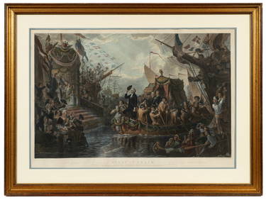
"First in Peace", Henry Breuckner & John McRae.Direct Auction Galleries 4.7(322)See Sold PriceFeb 24, 2024