ATLAS of ANTIENT GEOGRAPHY by SAMUEL BUTLER 1843John McInnis Auctioneers,LLC4.6(504)See Sold PriceFeb 24, 2024
18TH C. ANTIQUE MAP: FRENCH & INDIAN WAR, FRAMEDThomaston Place Auction Galleries4.4(389)See Sold PriceFeb 24, 2024
Rand McNally Railroad Map Cabinet w/ 21 Railroad MapsRail & Road Auctions4.6(165)See Sold PriceMar 08, 2024
Keith Haring - Ink on New York Map, Best Buddies, Inscribed, Signed, and DatedSapphire Auction Gallery4.1(67)See Sold PriceMar 02, 2024
LATE 17TH C. FRENCH MAP OF THE NEW WORLD BY ALEXIS-HUBERT JAILLOT (1632-1712)Thomaston Place Auction Galleries4.4(389)See Sold PriceFeb 24, 2024
Central Railroad of New Jersey Map of Sandy Hook Route-ca. 1903JM Hobby Supply and Railroad Artifact Auctions4.4(126)See Sold PriceFeb 24, 2024
Lot of Six Mixed Atlas Box Cars-HO Scale-New in BoxJM Hobby Supply and Railroad Artifact Auctions4.4(126)See Sold PriceFeb 25, 2024
Rand McNally/Santa Fe Railroad Map of Iowa-1912JM Hobby Supply and Railroad Artifact Auctions4.4(126)See Sold PriceFeb 24, 2024
NICOLAES VISSCHER (NETHERLANDS, 1618-1709) MAP OF THE NEW WORLDThomaston Place Auction Galleries4.4(389)See Sold PriceFeb 24, 2024
17TH C. WORLD MAP BY NICOLAES VISSCHER (NETHERLANDS, 1618-1709)Thomaston Place Auction Galleries4.4(389)See Sold PriceFeb 24, 2024
Lot of Six Mixed Atlas Cabooses-HO Scale-New in BoxJM Hobby Supply and Railroad Artifact Auctions4.4(126)See Sold PriceFeb 25, 2024
1865 Stulpnagel Map of Eastern United States --Title: 1865 Stulpnagel Map of Eastern United States -- Verein-Staaten von Nord-America mit Ausnahme Florida's und der Westlichen Territorien Date: 1865, Gotha Cartographer: F von Stulpnagel Size: 13.5See Sold Price
1865 Stulpnagel Map of Eastern United States --Title/Content of Map: 1865 Stulpnagel Map of Eastern United States -- Verein-Staaten von Nord-America mit Ausnahme Florida's und der Westlichen Territorien Cartographer: F von Stulpnagel Year/Place: 1See Sold Price
1865 Stulpnagel Map of Eastern United States --Title/Content of Map: 1865 Stulpnagel Map of Eastern United States -- Verein-Staaten von Nord-America mit Ausnahme Florida's und der Westlichen Territorien Date: 1865, Gotha Cartographer: F von StulpnSee Sold Price
1865 Stulpnagel Map of Eastern United States --Title/Content of Map: 1865 Stulpnagel Map of Eastern United States -- Verein-Staaten von Nord-America mit Ausnahme Florida's und der Westlichen Territorien Date: 1865, Gotha Cartographer: F von StulpnSee Sold Price
1865 Stulpnagel Map of Eastern United States --Title: 1865 Stulpnagel Map of Eastern United States -- Verein-Staaten von Nord-America mit Ausnahme Florida's und der Westlichen Territorien Cartographer: F von Stulpnagel Year / Place: 1865, Gotha MaSee Sold Price
1865 Stulpnagel Map of Eastern United States --Title: 1865 Stulpnagel Map of Eastern United States -- Verein-Staaten von Nord-America mit Ausnahme Florida's und der Westlichen Territorien Cartographer: F von Stulpnagel Year / Place: 1865, Gotha MaSee Sold Price
1865 Stulpnagel Map of Eastern United States --Title/Content of Map: 1865 Stulpnagel Map of Eastern United States -- Verein-Staaten von Nord-America mit Ausnahme Florida's und der Westlichen Territorien Date: 1865, Gotha Cartographer: F von StulpnSee Sold Price
1865 Stulpnagel Map of Eastern United States --Title: 1865 Stulpnagel Map of Eastern United States -- Verein-Staaten von Nord-America mit Ausnahme Florida's und der Westlichen Territorien Cartographer: F von Stulpnagel Year/Place: 1865, Gotha SizeSee Sold Price
MAP OF THE EASTERN UNITED STATES BY J. VON STULPNAGELHand-outlined lithograph map, 17' x 14 1/2', a depiction of the Eastern United States by J. von Stulpnagel, published 1847 in Gotha as part of 'Stieler's Hand-Atlas'. The map depicts the eastern UniteSee Sold Price
SoldAntique Map : Eastern United States - 1883Antique Map : Eastern United States - 1883. Hand-Tinted. Size : 13" x 11.25"See Sold Price
SoldGEORGIA & Southern Appalachia. Alabama Tennessee NC SCTITLE/CONTENT OF MAP: 'Eastern United States No 8' DATE PRINTED: 1883 IMAGE SIZE: Approx 44.0 x 35.5cm, 17.25 x 14 inches (Large); Please note that this is a folding map. TYPE: Antique colour atlas maSee Sold Price
NORTH & SOUTH CAROLINA COAST. Outer Banks. Sea Islands.TITLE/CONTENT OF MAP: 'Eastern United States No 3' DATE PRINTED: 1883 IMAGE SIZE: Approx 43.5 x 37.0cm, 17 x 14.5 inches (Large); Please note that this is a folding map. TYPE: Antique colour atlas mapSee Sold Price
US MIDWEST. Missouri Illinois Indiana Iowa Chicago.TITLE/CONTENT OF MAP: 'Eastern United States No 5' DATE PRINTED: 1883 IMAGE SIZE: Approx 36.0 x 41.0cm, 14.25 x 16.25 inches (Large); Please note that this is a folding map. TYPE: Antique colour atlasSee Sold Price
Stockdale: Antique Map of Eastern United States, 1798Title: 1798 Stockdale Map of Eastern United States -- Part of the United States of North America Cartographer: J. Stockdale Year / Place: 1798 London Map Dimensions: 18.4 x 16.2 in. Condition: Very GoSee Sold Price
Stockdale: Antique Map of Eastern United States, 1798Map: 1798 Stockdale Map of Eastern United States -- Part of the United States of North America Date Printed: 1798 London Cartographer: J. Stockdale Size: 18.4 x 16.2 in. Condition: Very Good. Issued fSee Sold Price
SoldWilliam Faden 1793 Map of Eastern United StatesThe United States of North American: with the British Territories and Those of Spain, according to the Treaty of 1784, Engraved by Wm Faden 1793. 25-3/4"h x 38"wSee Sold Price
Stockdale: Map of Eastern United States, 1798Map: 1798 Stockdale Map of Eastern United States -- Part of the United States of North America Cartographer: J. Stockdale Year / Place: 1798 London Map Dimensions: 18.4 x 16.2 in. Condition: Very GoodSee Sold Price
Sold1798 Stockdale Map of Eastern United StatesTitle/Content of Map: 1798 Stockdale Map of Eastern United States -- Part of the United States of North America Date Printed: 1798 London Cartographer: J. Stockdale Size: 18.4 x 16.2 in. This antiqueSee Sold Price
Marmocchi: Antique Map of Eastern United States, 1858Map: Stati Orientali della Unione Americana Cartographer: F.C. Marmocchi Place & Date: Milan / 1858 Size: 13 3/8" x 11" Condition: outline wash color; overall age toning An interesting and scarce 19thSee Sold Price
Soldc.1800 French Map of Eastern United States.From a Pelham Manor estate. Dimensions: 19" x 27." Condition: Laid down on cardboard, 1/2" margin at top, crease to the center.See Sold Price
Sold19th century colored map of Eastern United States19th century colored map of Eastern United States 17" X 19", in antique maple frameSee Sold Price
Sold1850 Map of Eastern United StatesMapsc. 1850s Map of the United States by Rapkin, Tallis & Co. c. 1850, Map of the “UNITED STATES”, Drawn and Engraved by J. Rapkin, Published by John Tallis & Company, London & New York, CSee Sold Price
SoldJohn Carey Map of Eastern United States From New1806, possible later hand-coloring. Presented in a black wooden frame. DOA 24.5 x 27.5 in.Additional high-resolution photos are available at LelandLittle.comSee Sold Price
SoldDetailed Map of Eastern United States.Lithographic map by noted cartographer S. Hall.See Sold Price
Small Tie-on Bannerstone, and Small Stone Pendant, found in the Eastern United StatesHeartland Artifact Auctions4.6(783)See Sold PriceMar 10, 2024
Wilson - Wood Thrush, Red-breasted Thrush or Robin, & Nuthatches. 2Trillium Antique Prints & Rare Books4.5(30)See Sold PriceFeb 24, 2024
Wilson - Grosbeak, Warbler, Siskin, & Flycatcher. 17Trillium Antique Prints & Rare Books4.5(30)See Sold PriceFeb 24, 2024
Wilson - Woodpeckers - Red-headed, Yellow-bellied, Hairy, & Downy. 9Trillium Antique Prints & Rare Books4.5(30)See Sold PriceFeb 24, 2024
Wilson - Cardinal Grosbeak & Red Tanager. 11Trillium Antique Prints & Rare Books4.5(30)See Sold PriceFeb 24, 2024
Wilson - Mottled Owl, Lark, Creeper, & Warbler. 19Trillium Antique Prints & Rare Books4.5(30)See Sold PriceFeb 24, 2024
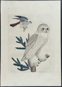
Wilson - Snow Owl (Snowy Owl) & Sparrow Hawk. 32Trillium Antique Prints & Rare Books4.5(30)See Sold PriceFeb 24, 2024
Wilson - Ivory-billed Woodpecker, Red-headed & Pileated Woodpeckers. 29Trillium Antique Prints & Rare Books4.5(30)See Sold PriceFeb 24, 2024
Wilson - Carolina Parrot & Flycatchers. 26Trillium Antique Prints & Rare Books4.5(30)See Sold PriceFeb 24, 2024
Stephen Koury Mourning Doves Original PaintingLegacy Auctions & Estate Sales4.6(72)See Sold PriceFeb 29, 2024
Martiros Manoukian LE Hand Signed SerigraphLegacy Auctions & Estate Sales4.6(72)See Sold PriceFeb 29, 2024
Martiros Hand Signed LE Mardi Gras Woman SerigraphLegacy Auctions & Estate Sales4.6(72)See Sold PriceFeb 29, 2024
Cooke, George 1801 Antique Map. United States of AmericaAlbion Auctions4.6(341)See Sold PriceMar 01, 2024
Blackie (Pub) 1882 Folio Map. United States of North AmericaAlbion Auctions4.6(341)See Sold PriceMar 01, 2024