ATLAS of ANTIENT GEOGRAPHY by SAMUEL BUTLER 1843John McInnis Auctioneers,LLC4.6(502)See Sold PriceFeb 24, 2024
18TH C. ANTIQUE MAP: FRENCH & INDIAN WAR, FRAMEDThomaston Place Auction Galleries4.4(386)See Sold PriceFeb 24, 2024
Rand McNally Railroad Map Cabinet w/ 21 Railroad MapsRail & Road Auctions4.6(165)See Sold PriceMar 08, 2024
Keith Haring - Ink on New York Map, Best Buddies, Inscribed, Signed, and DatedSapphire Auction Gallery4(67)See Sold PriceMar 02, 2024
LATE 17TH C. FRENCH MAP OF THE NEW WORLD BY ALEXIS-HUBERT JAILLOT (1632-1712)Thomaston Place Auction Galleries4.4(386)See Sold PriceFeb 24, 2024
Central Railroad of New Jersey Map of Sandy Hook Route-ca. 1903JM Hobby Supply and Railroad Artifact Auctions4.4(126)See Sold PriceFeb 24, 2024
Lot of Six Mixed Atlas Box Cars-HO Scale-New in BoxJM Hobby Supply and Railroad Artifact Auctions4.4(126)See Sold PriceFeb 25, 2024
Rand McNally/Santa Fe Railroad Map of Iowa-1912JM Hobby Supply and Railroad Artifact Auctions4.4(126)See Sold PriceFeb 24, 2024
NICOLAES VISSCHER (NETHERLANDS, 1618-1709) MAP OF THE NEW WORLDThomaston Place Auction Galleries4.4(386)See Sold PriceFeb 24, 2024
17TH C. WORLD MAP BY NICOLAES VISSCHER (NETHERLANDS, 1618-1709)Thomaston Place Auction Galleries4.4(386)See Sold PriceFeb 24, 2024
Lot of Six Mixed Atlas Cabooses-HO Scale-New in BoxJM Hobby Supply and Railroad Artifact Auctions4.4(126)See Sold PriceFeb 25, 2024
1864 Map of Pennsylvania and New JerseryAuthor: Johnson Title: 1864 Map of Pennsylvania and New Jersery Materials: Ink on Paper Dimensions: 25.5"X18" Description: Map of Pennsylvania and New Jersey dated 1864. Engraved by A.J. Johnson. PublSee Sold Price
1864 Johnson Map of Pennsylvania and New JerseyTitle/Content of Map: 1864 Johnson Map of Pennsylvania and New Jersey -- Johnson's Pennsylvania and New Jersey Date Printed: 1864, New York Cartographer: Johnson & Ward Size: 17.1 x 23.2 in. A nice, dSee Sold Price
Sold1864 Johnson Map of Pennsylvania and New Jersey --Title/Content of Map: 1864 Johnson Map of Pennsylvania and New Jersey -- Johnson's Pennsylvania and New Jersey Date: 1864, New York Cartographer: Johnson & Ward Size: 17.1 x 23.2 in. A nice, double paSee Sold Price
Sold1864 Johnsons Pennsylvania and New Jersey MapJohnson's Pennsylvania and New Jersey map, 1864 by A. J. Johnson, measures 18" x 26.5"See Sold Price
A Significant Railroad Map from 1864Heading: Author: Barnes, R.L Title: Railroad, Canal & County Map of Pennsylvania, New Jersey & Adjoining States Place Published: Philadelphia Publisher: Date Published: 1864 DescriptioSee Sold Price
SoldAntique maps, 19th centuryLot of two unframed antique maps, "West Indies" circa 1864 and "Pennsylvania & New Jersey" circa 1864 by A.J. Johnson, 18" x 26.5" eachSee Sold Price
Sold1 piece. Hand-Colored Lithographic Map. Johnson,1 piece. Hand-Colored Lithographic Map. Johnson, publisher. Johnson's Pennsylvania and New Jersey." New York, 1864. 17 1/2 x 24 1/2 inches; 445 x 622 mm. Some darkening & staining at lower corners. FrSee Sold Price
SoldCopy 1749 Map Pennsylvania, New Jersey, New YorkDESCRIPTION: Copy of 1749 Map of Pensilvania (sic), New Jersey, New-York and the Three Delaware Counties. Made by Lewis Evans. Colored borders, cities, townships, bodies of water, mountains labeled. DSee Sold Price
Barnes, R.L. Barnes railroad map Pennsylvania, NewBarnes, R.L. Barnes railroad, canal and county map of Pennsylvania, New Jersey and adjoining states, hand-col. Philadelphia: 1865Fifty mile scaleDimensions: 25" X 34 1/2"Inv.4See Sold Price
Barnes, R.L. Barnes railroad map Pennsylvania, NewBarnes, R.L. Barnes railroad, canal and county map of Pennsylvania, New Jersey and adjoining states, hand-col. Philadelphia: 1865Fifty mile scaleDimensions: 25" X 34 1/2"Inv.4See Sold Price
SoldJohnson: Antique Map of Pennsylvania & New Jersey, 1868Title/Content of Map: Pennsylvania & New Jersey by Johnson Date Printed: 1868 Cartographer: A.J. Johnson Material/Medium: Paper Size: 24" x 18" Hand colored steel engraved Map. From Johnson's New IlluSee Sold Price
SoldBradford: Antique Map of Pennsylvania & New Jersey 1835Title/Content of Map: Pennsylvania & New Jersey Date Printed: 1835 Cartographer: T.G. Bradford Material/Medium: Paper Size: 13" x 10" Condition: Excellent Hand colored outlines. Published in PhiladelpSee Sold Price
Pennsylvania & New JerseyTitle/Content of Map: Pennsylvania & New Jersey Date: 1866 Cartographer: by Johnson Size: 18x29” Provenance: New York. Double sheet map that split along the center fold fully. Needs reattaching. MinSee Sold Price
Pennsylvania & New Jersey.Title/Content of Map: Pennsylvania & New Jersey. Date 1866 Cartographer: Johnson Size: 18x29” Provenance: New York. Double sheet map that split along the center fold fully. Needs reattaching. MinorSee Sold Price
SoldAsher & Adams: Map of Pennsylvania & New Jersey, 1872Nicely colored Asher & Adams Pennsylvania and New Jersey. 1872. 15.75 x 22.75. Striking example of an Asher & Adams map which are often pale in hand coloring, or somewhat brittle. This one is nicely cSee Sold Price
SoldPocket Map of Pennsylvania, New Jersey and DelawarePocket map of the Map of Pennsylvania, New Jersey and Delaware, Constructed from the latest authorities. D.H. Vance del. J.H. Young Sc. Published by A. Finley Philada, 1825. Is inscribed on the insideSee Sold Price
Sold1864 Map of New York Railroads"Map of the Rail Roads of the State of New York prepared under the direction of William B Taylor...". S. H. Sweet , deputy state engineer and surveyor. Printed by C. Van Benthuysen, Albany. Printed wiSee Sold Price
SDUK: Antique Map of Pennsylvania, New Jersey, DC, 1844Title/Content of Map: 'NORTH AMERICA, SHEET VII., Pennsylvania, New Jersey, Maryland, Delaware, Columbia, Virginia' Date Printed: This map was originally published by Baldwin & Cradock in 1833; this dSee Sold Price
SoldFramed Vintage Map. McNally's. Pennsylvania, NewFramed Vintage Map. McNally's. Pennsylvania, New Jersey. Delaware and Maryland. Hand colored Wood Engraving. c 1860. -- Dimensions: Image Size: H: 9 inches: W: 11 inches ---See Sold Price
SoldEngraved and hand colored map of Pennsylvania, NewEngraved and hand colored map of Pennsylvania, New Jersey and New York by Matthew Seutterum, ca. 1740, 23'' x 19 3/4''.See Sold Price
SoldCa 1830 Pocket Map of Pennsylvania, New Jersey &Ca 1830 Pocket Map of Pennsylvania, New Jersey & Delaware-- Dimensions: ---See Sold Price
Pre-Revolutionary War era map of Pennsylvania, NewPensylvania Nova Jersey et Nova York cum Regionibus Ad Fluvium Delaware In America Sitis, Nova Delinatione ob oculos posita...Tobias Conrad Lotter (1717 - 1777). Engraved map with handcolor in part. ASee Sold Price
SoldHand-colored map of Pennsylvania, New Jersey, MarHand-colored map of Pennsylvania, New Jersey, Maryland and Delaware dated 1860, by Augustus Mitchell, Jr. 12.5"x15.5See Sold Price
AFTER William M Harnett (PA,NY,1842-1892) oil paintingBroward Auction Gallery4.8(277)See Sold PriceMar 10, 2024
Anthony Michael Autorino (PA,NJ,France,1937-2015) oil paintingBroward Auction Gallery4.8(277)See Sold PriceMar 31, 2024
Hal Singer (NY,PA,NJ,1919-2003) oil paintingBroward Auction Gallery4.8(277)See Sold PriceMar 31, 2024
Jon Henry 1916-90 O/C Painting Titled "Prism Series #11" 1989Rbfinearts4.4(571)See Sold PriceFeb 24, 2024
Jon Henry 1916-90 O/C Painting Titled "Prism Series #5" 1988Rbfinearts4.4(571)See Sold PriceFeb 24, 2024
Early Pennsylvania Railroad Literature - 1881 New York and Chicago Limited Timetable Brochure andRail & Road Auctions4.6(165)See Sold PriceMar 07, 2024
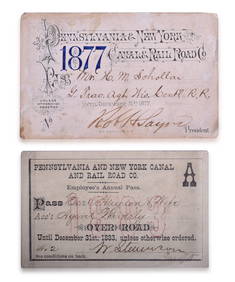
Pair of Pennsylvania & New York Canal & Railroad Co. Annual Passes - 1877 and 1883Rail & Road Auctions4.6(165)See Sold PriceMar 08, 2024
[SHEET MUSIC]. [PETROLEUM]. WATSON, J. J. American Petroleu...Potter & Potter Auctions4.6(539)See Sold PriceMar 07, 2024
[CIVIL WAR]. Partly printed discharge document for Private. Philip Pledger, Company B, 20th RegimentFreeman's | Hindman4.4(1.6k)See Sold PriceFeb 27, 2024
Keith Haring (Reading, Pennsylvania 1958 - 1990 New York) (after)Medusa Auctioneers4.3(6)See Sold PriceMar 04, 2024
1855 NOTES ON CENTRAL AMERICA by E. G. Squier antique w/ MAPSJasper524.5(9.8k)See Sold PriceFeb 27, 2024
1764 MAP OF COUNTRIES THIRTY MILES ROUND LONDON antique 12.5 by 15"Jasper524.5(9.8k)See Sold PriceFeb 27, 2024
Antique Pennsylvania Map Fragment incl Wellersburg and New CentervilleCordier Auctions4.4(1.5k)See Sold PriceMar 02, 2024


![[SHEET MUSIC]. [PETROLEUM]. WATSON, J. J. American Petroleu... (1 of 1)](https://p1.liveauctioneers.com/928/318880/171361187_1_x.jpg?height=282&quality=70&version=1707501302)
![[CIVIL WAR]. Partly printed discharge document for Private. Philip Pledger, Company B, 20th Regiment (1 of 2)](https://p1.liveauctioneers.com/197/319238/171468123_1_x.jpg?height=282&quality=70&version=1707520367)