ATLAS of ANTIENT GEOGRAPHY by SAMUEL BUTLER 1843John McInnis Auctioneers,LLC4.5(505)See Sold PriceFeb 24, 2024
18TH C. ANTIQUE MAP: FRENCH & INDIAN WAR, FRAMEDThomaston Place Auction Galleries4.4(393)See Sold PriceFeb 24, 2024
Rand McNally Railroad Map Cabinet w/ 21 Railroad MapsRail & Road Auctions4.6(165)See Sold PriceMar 08, 2024
Keith Haring - Ink on New York Map, Best Buddies, Inscribed, Signed, and DatedSapphire Auction Gallery4.1(67)See Sold PriceMar 02, 2024
LATE 17TH C. FRENCH MAP OF THE NEW WORLD BY ALEXIS-HUBERT JAILLOT (1632-1712)Thomaston Place Auction Galleries4.4(393)See Sold PriceFeb 24, 2024
Central Railroad of New Jersey Map of Sandy Hook Route-ca. 1903JM Hobby Supply and Railroad Artifact Auctions4.4(127)See Sold PriceFeb 24, 2024
Lot of Six Mixed Atlas Box Cars-HO Scale-New in BoxJM Hobby Supply and Railroad Artifact Auctions4.4(127)See Sold PriceFeb 25, 2024
Rand McNally/Santa Fe Railroad Map of Iowa-1912JM Hobby Supply and Railroad Artifact Auctions4.4(127)See Sold PriceFeb 24, 2024
NICOLAES VISSCHER (NETHERLANDS, 1618-1709) MAP OF THE NEW WORLDThomaston Place Auction Galleries4.4(393)See Sold PriceFeb 24, 2024
17TH C. WORLD MAP BY NICOLAES VISSCHER (NETHERLANDS, 1618-1709)Thomaston Place Auction Galleries4.4(393)See Sold PriceFeb 24, 2024
Lot of Six Mixed Atlas Cabooses-HO Scale-New in BoxJM Hobby Supply and Railroad Artifact Auctions4.4(127)See Sold PriceFeb 25, 2024
1864 Johnson Map of Evolving US West -- Johnson'sTitle: 1864 Johnson Map of Evolving US West -- Johnson's California, with Utah, Nevada, Colorado, New Mexico, and Arizona Cartographer: Johnson & Ward Year / Place: 1864, New York Map Dimension (in.):See Sold Price
1864 Johnson Map of US West -- Johnson's California, with Utah, Nevada, Colorado, New Mexico, andTitle: 1864 Johnson Map of US West -- Johnson's California, with Utah, Nevada, Colorado, New Mexico, and Arizona Cartographer: Johnson and Ward Year / Place: 1864, New York Map Dimension (in.): 16.9 XSee Sold Price
1863 Johnson Map of US West -- Johnson's California Territories of New Mexico Arizona ColoradoTitle: 1863 Johnson Map of US West -- Johnson's California Territories of New Mexico Arizona Colorado Nevada and Utah Cartographer: Johnson & Ward Year / Place: 1863, New York Map Dimension (in.): 17.See Sold Price
A.J. JohnsonArtist: A.J. Johnson, West Indies Map, 1864 A.J. Johnson Size: 18 3/8" x 22" West Indies Map, 1864See Sold Price
Solddated 1864 Johnson's hand colored map of the Westdated 1864 Johnson's hand colored map of the West Indies - 16"x23"See Sold Price
SoldMap of the West Indies, Johnson, NY, 1864, 21" X 1Map of the West Indies, Johnson, NY, 1864, 21" X 15"See Sold Price
1864 Johnson's Map of VA, DE, MA, & WV, A.J. Johnson NY19th century. A hand-colored American Civil War era map of Virginia, Delaware, Maryland, and West Virginia. Published by A.J. Johnson New York USA. Marked as page 47. Overall good condition; some broSee Sold Price
SoldTwo Maps by Johnson & Ward, "West Indies," 1864, handTwo Maps by Johnson & Ward, "West Indies," 1864, hand colored, H.- 17 7/8 in., W.- 26 1/2 in.; together with "South America," 1860, hand colored, H.- 26 1/2 in., W.- 18 1/4 in. (2 Pcs.)See Sold Price
SoldFRAMED JOHNSON'S WEST INDIES MAP1864 Map of the West Indies, from "Johnson's New Illustrated Family Atlas of the World", covers the bottom tip of Florida to the top of Venezuela, with inset of Bermuda, with remnants of original handSee Sold Price
SoldJohnson's Map of the West Indiescolored lithograph, (New York: A. J. Johnson, 1864). Presented in modern wooden frame. DOA 23.5 x 30 in.Additional high-resolution photos are available at LelandLittle.comSee Sold Price
SoldCivil War Era Map, Johnson's Virginia, Delaware,Civil War Era Map, Johnson's Virginia, Delaware, Maryland & West Virginia(New York: A. J. Johnson, 1864), steel engraving with color, this being one of the earlier maps showing the new state of West VSee Sold Price
Sold1863 Johnson’s Nebraska, Dakota, Colorado, Idaho Map1864 Johnson’s Nebraska, Dakota, Colorado, Idaho, Kansas. Johnson & Ward. Johnson and Ward's rare 1863 map of the territories of Idaho, Dakota, Nebraska, Colorado and Kansas. Extends west as far asSee Sold Price
Three Maps by Johnson & Ward, Two "Virginia, Delaware,Three Maps by Johnson & Ward, Two "Virginia, Delaware, Maryland, West Virginia," one "Virginia, Delaware and Maryland," 1864, hand colored, H.- 18 in., W.- 27 3/4 in. (3 Pcs.)See Sold Price
SoldJohnson's North America,'' c.1860-1867[North America]. Johnson's North America. Double-page map, including central America, Alaska, and most of Greenland. [Phila]: Johnson and Ward, c.1864-1867. West Virginia is shown as separate state, aSee Sold Price
Sold1864 Johnson Map of Dakota Territory and MinnesotaTitle/Content of Map: 1864 Johnson Map of Dakota Territory and Minnesota -- Johnson's Minnesota and Dakota Date Printed: 1864, New York Cartographer: Johnson & Ward Size: 12.5 x 15.6 in. This is an inSee Sold Price
Sold1864 Johnson Map of North and South Carolina --Title/Content of Map: 1864 Johnson Map of North and South Carolina -- Johnson's North and South Carolina Date: 1864, New York Cartographer: Johnson & WardSize: 17.3 x 24 in. An excellent, large, doublSee Sold Price
Sold1864 Johnson Map of Michigan and Wisconsin -- Johnson'sTitle/Content of Map: 1864 Johnson Map of Michigan and Wisconsin -- Johnson's Michigan and Wisconsin Cartographer: Johnson & Ward Year/Place: 1864, New York Size: 17 X 23 in. This is a large and highlSee Sold Price
Sold1864 Johnson Map of Texas -- Johnson's New Map of theTitle/Content of Map: 1864 Johnson Map of Texas -- Johnson's New Map of the State of Texas Date: 1864, New York Cartographer: Johnson & Ward Size: 16.7 X 24.5 in. This a double page, large, quite attrSee Sold Price
Sold1864 Johnson Map of the Roman Empire -- Johnson's RomanTitle/Content of Map: 1864 Johnson Map of the Roman Empire -- Johnson's Roman Empire, Imperium Romanorum Latissime Patens Date: 1864, New York Cartographer: Johnson & Ward Size: 13 X 20.7 in. This isSee Sold Price
Sold1864 Johnson Map of Maryland and Deleware -- Johnson'sTitle/Content of Map: 1864 Johnson Map of Maryland and Deleware -- Johnson's Deleware and Maryland Date: 1864, New York Cartographer: Johnson & Ward Size: 12.6 x 15.5 A very nice map of these two mid-See Sold Price
Sold1864 Johnson's Map of Ohio -- Johnson's OhioReserve Reduced! Title/Content of Map: 1864 Johnson's Map of Ohio -- Johnson's Ohio Date: 1864, New York Cartographer: A Johnson Size: 17 X 22.5 in. An excellent larger county map of Ohio; however, thSee Sold Price
Sold1864 Johnson Map of North and South Carolina --Title/Content of Map: 1864 Johnson Map of North and South Carolina -- Johnson's North and South Carolina Date Printed: 1864, New York Cartographer: Johnson & Ward Size: 17.3 x 24 in. An excellent, larSee Sold Price
Sold1864 Johnson Map of the United States -- Johnson'sTitle/Content of Map: 1864 Johnson Map of the United States -- Johnson's United States Date: 1864, New York Cartographer: A Johnson Size: 16.9 x 23.1 in. This is a large, highly detailed Civil War eraSee Sold Price
Sold1864 Johnson Map of the Roman Empire -- Johnson's Roman1864 Johnson Map of the Roman Empire -- Johnson's Roman Empire in the time of Christ and his Apostles, 19" X 25" on board and nicely wood framed, good condition, HANDLING/SHIPPING in house for this itSee Sold Price
Central Railroad of New Jersey Map of Sandy Hook Route-ca. 1903JM Hobby Supply and Railroad Artifact Auctions4.4(127)See Sold PriceFeb 24, 2024
FLYING A TOURING SERVICE U.S. ROAD MAPS TIN WALL DISPLAY.Dan Morphy Auctions4.2(1.3k)See Sold PriceFeb 25, 2024
The Johnson Johnson Yellowlegs Decoy by J. Taylor Johnson (1853-1929)Copley Fine Art Auctions4.5(40)See Sold PriceFeb 24, 2024
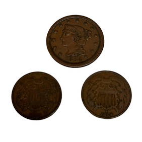
Two US 2 Cent Coins and 1854 Large One CentPremier Auction Galleries4.3(331)See Sold PriceMar 09, 2024
Turn of the Century Scrapbook W/ over 430 Tobacco CardsPast to Present Auctions4.3(7)See Sold PriceMar 02, 2024
US PRESIDENT LBJ & LADY BIRD JOHNSON AUTOGRAPHED PHOTOOmnia Auctions4.7(324)See Sold PriceFeb 26, 2024
[VIETNAM]. A group of approx. 120 photographs assembled by African American soldier Vernon CliftonFreeman's | Hindman4.4(1.6k)See Sold PriceFeb 27, 2024
[ADVERTISING]. Red Cross Cotton, From Start to Finish. New Brunswick, NJ: Johnson & Johnson, 1894.Freeman's | Hindman4.4(1.6k)See Sold PriceFeb 27, 2024
Audubon, Amsterdam Ed - Key West Dove. 167Trillium Antique Prints & Rare Books4.5(32)See Sold PriceFeb 24, 2024
R. Crumb (American, b. 1943) Robert Johnson, 1988Freeman's | Hindman4.4(1.6k)See Sold PriceMar 07, 2024
Map of Part of the West Indies, Etc., Showing the Exact Position Of The U.S. War Steamer SanJasper524.5(9.9k)See Sold PriceFeb 27, 2024
Johnson's Africa. Colonies & tribes. Liberia Nile Delta Cape Colony 1866 mapJasper524.5(9.9k)See Sold PriceFeb 28, 2024
West Coast U.S. Vintage Travel Maps, Brochures 46Grant Zahajko Auctions, LLC4.7(1k)See Sold PriceMar 06, 2024


![[VIETNAM]. A group of approx. 120 photographs assembled by African American soldier Vernon Clifton (1 of 6)](https://p1.liveauctioneers.com/197/319238/171468143_1_x.jpg?height=282&quality=70&version=1707520367)
![[ADVERTISING]. Red Cross Cotton, From Start to Finish. New Brunswick, NJ: Johnson & Johnson, 1894. (1 of 2)](https://p1.liveauctioneers.com/197/319238/171468146_1_x.jpg?height=282&quality=70&version=1707520367)